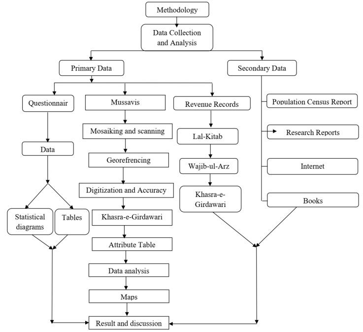
In this section, analysis has been performed with a main importance on land fragmentation and land use. The discussion is supported by statistical information that was gathered from both primary and secondary sources. Furthermore, the causes of land fragmentation and its impact on land use have been elaborated.
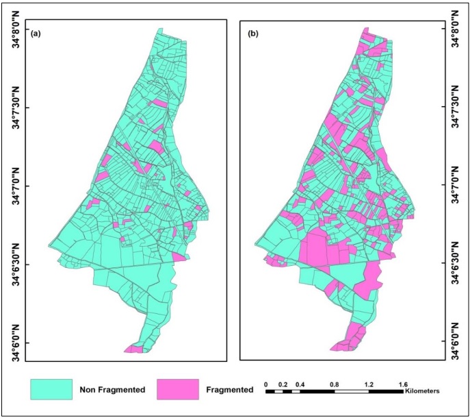
Figure 3:Land Fragmentations in Village Ghalji Kander Khel (a) 1990-91, (b) 2020-21
Land Fragmentation in Village Ghalji Kander Khel:
Analysis results showed that in Village Ghalji Kander Khel land fragmentation increased from 1990-91 to 2020-21. It was found from the analysis that in 1990-91, out of 819 plots, the number of fragmented plots is 38 spreading 260.5 kanal* (5.6%) represented in the color pink whereas the rest are non-fragmented plots and are represented in blue. In 2020-21 out of 819 plots, 156 plots were fragmented covering an area of 1093.1kanal or 23.9% which shows an increase in land fragmentation (Figure 3).
According to revenue records, in Ghalji kander khel during 1990-91, out of 819 plots, there were 38 fragmented plots which consistently increased to 156 plots in 2020-21. The field survey also confirmed that land fragmentation increased in 2020-21 and this increase is mainly because of the law of inheritance (Table 1; Figure 4).
Table 1:Land Fragmentation, Village Ghalji Kander Khel
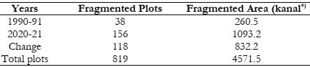
Source: Revenue Record of Village Ghalji Kander Khel for the agriculture census 1990-91 and 2020-21 *1 kanal =506 m2
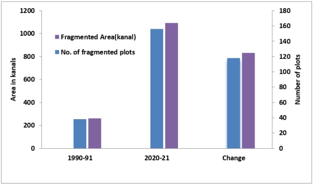
Figure 4:Village Ghalji Kander Khel, Land Fragmentation, 1990-91and 2020-21
Type of Land Fragmentation:
In the study area, there are two types of fragmentation namely cultivated fragmentation and cultivated/uncultivated fragmentation. In cultivated fragmentation, the land is divided into fragments that are used only for cultivation while in cultivated/uncultivated fragmentation the plot is divided into such fragments that one part of this land is used for cultivation while the other part is converted to uncultivated land.
The analysis reveals that in 1990-91 only 5% of land was cultivated fragmented land which increased to 72% in 2020-21. Fragmented cultivated/uncultivated land was 2% in 1990-91 which increased to 22% in 2020-21. From the field survey, it is revealed that 93% of the respondent replied that in 1990-91 their land was not fragmented while 94% replied that in 2020-21 their lands were fragmented (Figure 5).

Figure 5:Village Ghalji Kander Khel, the response of owners about the type of land fragmentation
Land Fragmentation in Village Mathra:
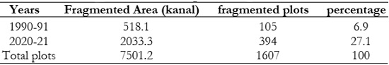
The situation in the sample study village between 1990–1991 and 2020–2020 shows that land fragmentation is properly common within the Village Mathra. Out of 1607 total plots, only 105 were fragmented in 1990–1991; these plots covered an area of 518.1 kanal (6.9%). Light pink represents plots with two fragments, dark pink represents plots with three fragments and Blue color represents plots that are not fragmented. Out of 1607 total plots, 394 were fragmented in 2020–2021, making up 2033.3 kanals (27.1% of the total area of the land), a rise of 21 percent in around 30 years (Figure 6).
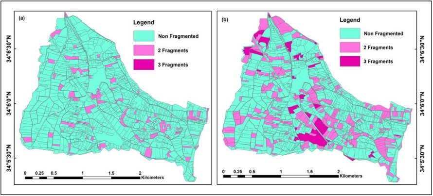
Figure 6:Village Mathra Land Fragmentation (a) 1990-91(b) 2020-21
The findings show the total area and plots from 1990–1991 to 2020–2021. Land fragmentation in 1990–1991 only affected 105 plots, or 5.9% of the total land, covering an area of 518.1 kanal. By 2020–2021, it had grown to 394 plots, or 27.1% of the entire land, covering an area of 2033.37kanal (Figure 7; Table 2).
Table 2:Village Mathra Land Fragmentation, 1990-91 and 2020-21
Source: Revenue Record of Village Mathra.
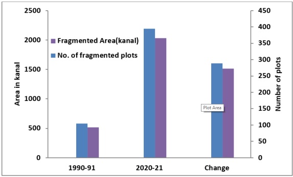
Figure 7:Village Mathra, Land Fragmentation in 1990-91and 2020-21
Type of Land Fragmentation:
The analysis reveals the type of land fragmentation in 1990-91 and 2020-21. In 1990-91 only 5% was cultivated fragmented land which increased to 24% in 2020-21. Fragmented cultivated/uncultivated land was 6% in 1990-91 which increased to 72% in 2020-21. It is analyzed from the field survey that 89% of the respondent replied that in 1990-91 their land was not fragmented while 96% replied that in 2020-21 their lands were fragmented(Figure 8)
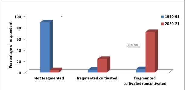
Figure 8:Village Mathra Type of Land Fragmentation, 1990-91and 2020-21
Causes of Land Fragmentation:
There are several reasons for land fragmentation, and they differ among countries [12]. However, the majority of scholars agreed that there are four key causes of agricultural fragmentation. The most well-known of these is known as the law of inheritance. According to inheritance law, the land must be divided among the possible heirs by specified legal proportions. Every sort of land is divided up and distributed among heirs because each piece of land has a different potential. Fragmentation is reduced when the farm's fertility remains constant. Another element that increases competition for land is population expansion. The land market is yet another factor that is considered to increase land fragmentation.
The field survey's findings indicate that the inheritance law is the primary cause of land fragmentation in the study area, followed by population growth, market values, economic woes, social issues, and government infrastructure (Figure 9).
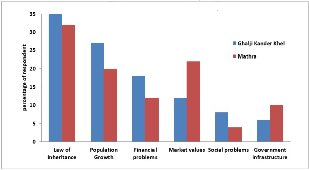
Figure 9:Causes of Land Fragmentation in selected Villages
Land Fragmentation Impact on Land Use:
The impacts of land fragmentation are examined in literature from several scientific disciplines, including agriculture, sociology, anthropology, geography, economics, and agricultural policy [18]. The basic idea is that fragmentation, which is fundamentally split in nature, has an influence on economies of scale and leads to conflicts. It is therefore thought to restrict agricultural development and production effectiveness [19][20]. Critics of land fragmentation, especially economists, authorities in charge of agricultural policy, and geographers, believe that small, asymmetrical plots limit the efficiency of agricultural output. As the distance between plots and farming grows, the cost of transportation, monitoring, and travel time rises.
Additionally, regular and irregular borders, as well as plot patchworks, result in a loss or waste of effective land area. These limits also increase the risk of neighbor disputes and conflicts, obstruct the mechanization of agriculture, and stop the development of drainage and irrigation systems. The cultivation of more significant crops, which typically need larger farms, is further restricted by tiny, dispersed farms, as is banks' willingness to provide farmers loans when they offer small pieces of land as security. This limits investment in agriculture's development, hence limiting economies of scale. Because of the expenses, which reduce farm productivity and farmer income, the economic advantages of increased agricultural productivity and decreased agricultural fragmentation are equal [21][22]. Another risk is that some areas farther from the source may not even farmed [23]. Green space shrinks as a result of land fragmentation. Trees have been cut down as human habitation has expanded. The environment becomes out of balance as a result of weather-related events such as earthquakes, floods, and storms. The effects are thought to be a large reduction in trees and an acceleration of soil erosion as a result of increased settlement and nuclear families [24].
Village Ghalji Kander Khel Land Use Pattern, 1990-91 to 2020-21:
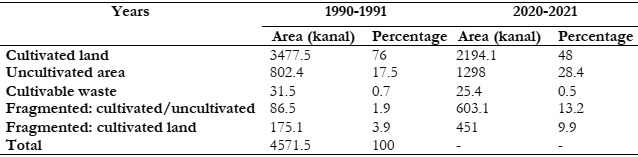
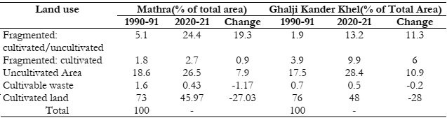
According to authorized revenue data, Ghalji Kander Khel has a total area cover of 4571.5 kanal. From 1990-91 to 2020-21, cultivated land (net sown and current fallow land) decreased from 3477.5 kanal (76%) to 2184.1 kanal (48%) shown in a light green color. Uncultivated land was approximately 802.40 kanal (17.5%) in 1990–1991 (shown in pink), and it climbed to 1298.1 kanal (28.4%) in 2020–2021 (shown in green). Uncultivated land includes the area under roads, graveyards, built environments, water bodies, and other similar uses. Fragmented cultivated/uncultivated covered an area of 86.5 kanal (1.9%) in 1990–1991 (shown in light sea green color), which extends over an area of 603.1kanal (13.2%) in 2020–21. The fragmented cultivated area was 175 kanal (3.9%) in 1990–1991 and expanded to 451.1 kanal (9.9%) in 2022–2021. Cultivable waste (due to factors such as being common land) was around 31.5 kanal (0.7%) in 1990–1991 (shown in yucca yellow), but it was put to other uses and dropped to 25.4 kanal (0.5%) in 2020–2021 (Figure 10).
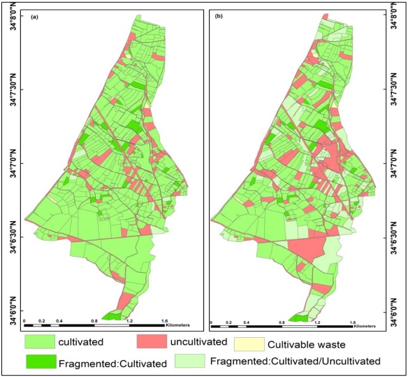
Figure 10:Village Ghalji Kander Khel, Land Use Analysis (a) 1990-91(b) 2020-21
The analysis shows that cultivable wasteland in Village Ghalji Kander Khel in 1990–1991 was around 31.5 kanal (0.7%) of the total land, which fell to 25.4 kanal (0.5%) in 2020-21. A decrease in the amount of cultivated land from 3477.5 kanal (76%) in 1990–1991 to 2194.1 kanal (48%) in 2020-21 will result in increased food security in the next years. On the other hand, uncultivated land expanded, rising from 802.4 kanal (17.5%) in 1990–1991 to 1298 kanal (28%) in 2020–21. The amount of fragmented cultivated land grew from 175.1 kanal (3.9%) in 1990–1991 to 451 kanal (9.9%) in 2020–21. Between 1990–1991 and 2020–2021, the amount of fragmented cultivated and uncultivated land proceeded from 86.5 kanal (1.9%) to 603.1 kanal (13.2%). According to the findings, both cultivated land and cultivable waste declined. From 1990–1991 to 2020–2021, there was an increase in uncultivated land, fragmented cultivated land, and fragmented cultivated/uncultivated land (Figure 11; Table 3).
Table 3:Village Ghalji Kander Khel, Temporal Analysis of Land Use
Source: Extracted from Revenue Record of Village Ghalji Kander Khel
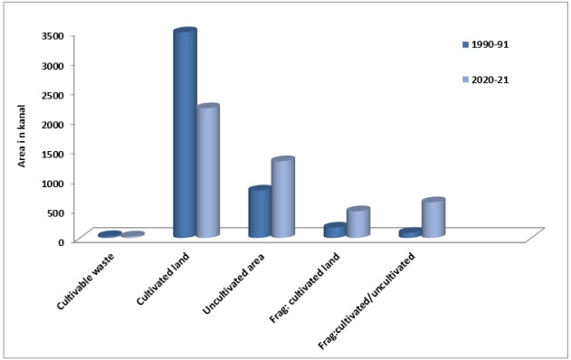
Figure 11:Village Ghalji Kander Khel, Temporal Analysis of Land Use
Village Ghalji Kander Khel Land Use Conversion, 1990-91 to 2020-21:
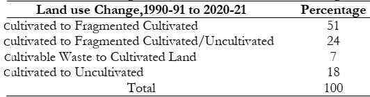
From the field survey, it is analyzed that 7% of respondents said there had been a change from cultivable waste to cultivated land; 18% said there had been a change from cultivated to uncultivated; 51% said there had been a change from cultivated to fragmented cultivated; and 24% said there had been a change from cultivated to fragmented cultivated/uncultivated. According to the data, most cultivated land is transferred to other land uses. Less cultivable wasteland is turned into cultivation (Table 4; Figure 12).
Table 4:Village Ghalji Kander Khel Land Use change
Source: Field Survey, October.2022
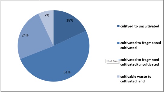
Figure 12:Village Ghalji Kander Khel, Land Use change, 1990-91 to 2020-21
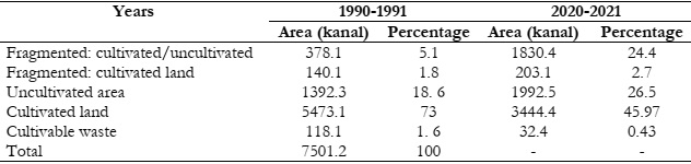
Village Mathra Land Use Pattern, 1990-91 to 2020-21:
According to authorized revenue data, the total area covered is 7501.2 kanal, of which 5473.2 kanal (73%) was cultivated (net sown and current fallow land) in 1990–1991; the proportion dropped to 3444.4 kanal (45.97%) in 2020–21. Due to circumstances such it being common land, the amount of cultivable waste is approximately 118.1 kanal (1.6%) in 1990–1991 (depicted in yucca yellow), which is put to other purposes and decreases to 32.4 kanal (0.43%) in 2020–2021. The uncultivated land, which is shown in pink color, increased from 1392.3 kanal (18.6%) in 1990–1991 to 1992.5 kanal (26.5%) in 2020–2021. Fragmented cultivated area grew to 203.1 kanal (2.7%) in 2020–21 from 140.1 kanal (1.8%) in 1990–91, which can be seen in dark green. Fragmented cultivated/uncultivated area in 1990–1991 was 378.1 kanal (5.1%) indicated in light sea green, but it rose to 1830.4 kanal (24.4%) in 2020–2021 (Figure 13).
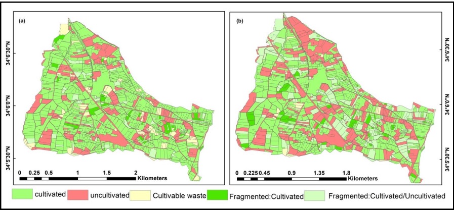
Figure 13:Temporal Analysis of Land Use in Village Mathra (a) 1990-91(b) 2020-21
It is revealed from the analysis that land use in Village Mathra was as; the proportion of fragmented cultivated and uncultivated land grew from 378.1 kanal (5.1%) in 1990–1991 to 1830.4 kanal (24.4%) in 2020–21. Fragmented cultivated land also grew from 140.1 kanal (1.8%) in 1990–1991 to 203.1 kanal (2.7%) in 2020–2021. Uncultivated land increased from 1392.3kanal (18.6%) in 1990-91 to 1992.5 kanal (26.5%) in 2020-21. The proportion of land that was cultivated declined from 5473.1 kanal (73%) in 1990–1991 to 3444.4 kanal (45.97%) in 2020–21. Cultivable waste land reduced from 118.1 kanal (1.6%) of the total area to 32.4 kanal (0.43 According to the study, both cultivated land and cultivable waste declined. From 1990–1991 to 2020–2021, there was an increase in uncultivated land, fragmented cultivated land, and fragmented cultivated/uncultivated land (Figure 14; Table 5).
Table 5:Village Mathra Temporal Analysis of Land Use
Source: Revenue Record of Village Mathra for the agriculture census 1990-91and 2020-21
Figure 14:Village Mathra Temporal Analysis of Land Use
Village Mathra Land Use change, 1990-91 to 2020-21:
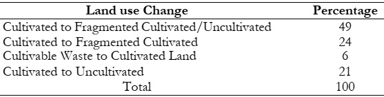
According to the research, the change in Village Mathra took place between 1990–1991 and 2020–21 and 49% of respondents responded change is from cultivated to fragmented cultivated/uncultivated, 24% of respondents responded change occurred from cultivated to fragmented cultivated, 6% of respondents, change occurred from cultivable waste to cultivated land and 21% of respondents responded change occurred from cultivated to uncultivated. The analysis shows that the majority of cultivated land is converted to other land uses. For example, more land is converted to uncultivated and fragmented cultivated/uncultivated, less land is converted to fragmented cultivated, and only a very small portion of land is converted from cultivable waste to cultivated land (Table 6; Figure 15).
Table 6:Village Mathra Land Use Change, 1990-91 to 2020-21
Source: Field Survey, October ,2022
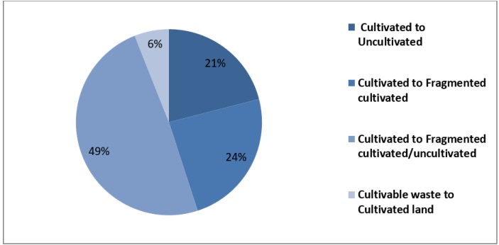
Figure 15:Land use Change 1990-91 to 2020-21 in Village Mathra
Village Ghalji Kander Khel and Village Mathra, Land Use Comparison 1990-91 and 2020-21:
It can be shown through a comparison of the two villages that overall cultivation has decreased in both. In Mathra, the cultivated area declined from 73% to 45.97%, while in Ghalji Kander Khel, it fell from 76% to 48%. The proportion of cultivable waste has dropped from 1.6% to 0.43% in Mathra and from 0.7% to 0.5% in Ghalji Kander Khel. The uncultivated land has grown in both villages from 18.6% to 26.5% in Mathra and from 17.5% to 28.4% in Ghalji Kander Khel. In both villages, the amount of fragmented land has increased; in Ghalji Kander Khel, the amount of fragmented cultivated land is greater (3.9% to 9.9%) than in Mathra (1.8% to 2.7%); meanwhile, the amount of fragmented cultivated/uncultivated land is greater in Mathra (5.1% to 24.2%) than in Ghalji Kander Khel (1.9% to 13.2%) (Figure 16).
According to the analysis, the change in cultivable waste, cultivated land, uncultivated land, fragmented cultivated land, and fragmented cultivated/uncultivated land is -0.2, -28, +10.9, +6, and +11.3 respectively in Ghalji Kander Khel, while in the village of Mathra, the conversion is -1.17, -27.03, +7.9, +0.9, and +19.3. According to the study, fragmented cultivation occurred mostly in the village of Ghalji Kander Khel, but in the village of Mathra, there was a greater proportion of fragmented cultivation/uncultivated land. Village Mathra is represented between 1990-1991 and 2020-21 on a bar graph, together with Village Ghalji Kander Khel (Figure 17, 18; Table 7).
Table 7:Comparative Analysis of Land Use in Sample Villages
Source: Revenue Record
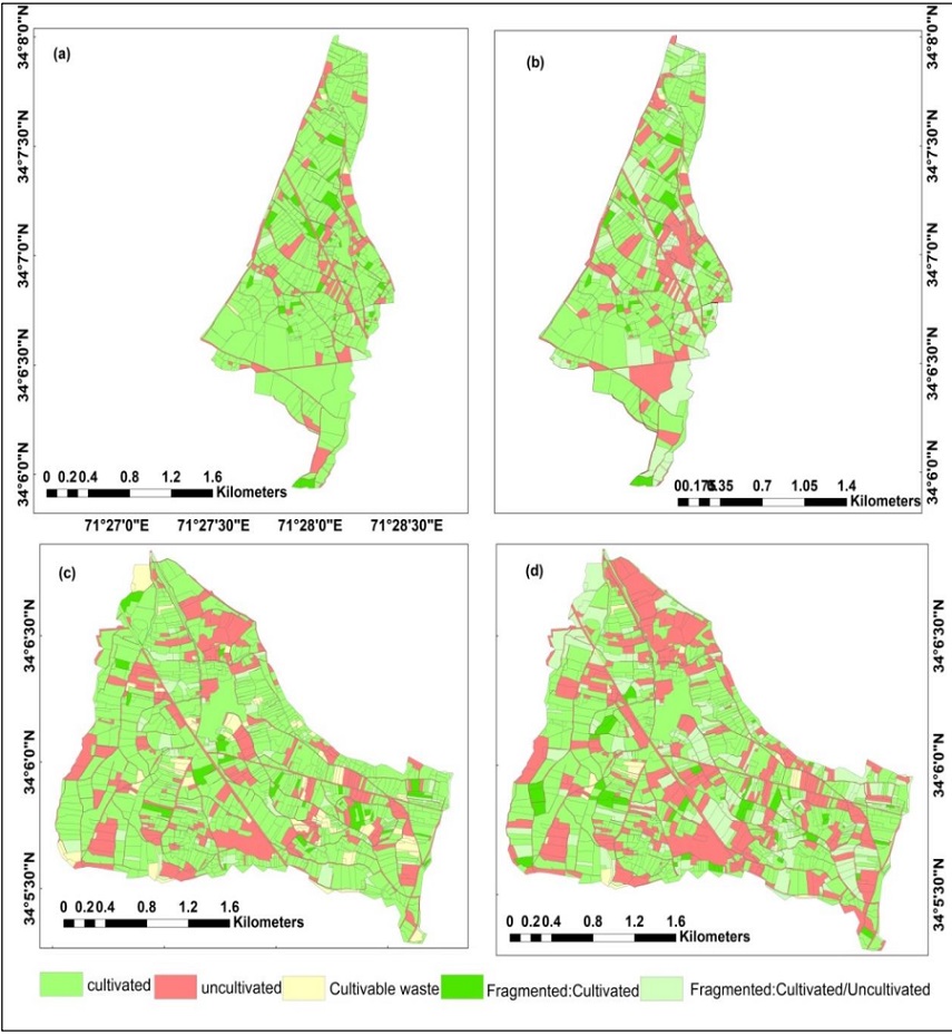
Figure 16:Land Use Analysis In Selected Villages,(a)Village Ghalji Kander Khel, 1990-91(b) Village Ghalji Kander Khel, 2020-21(c)Village Mathra, 1990-91(d)Village Mathra, 2020-21
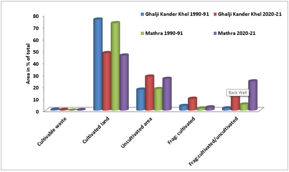
Figure 17:Land Use Analysis in selected Villages
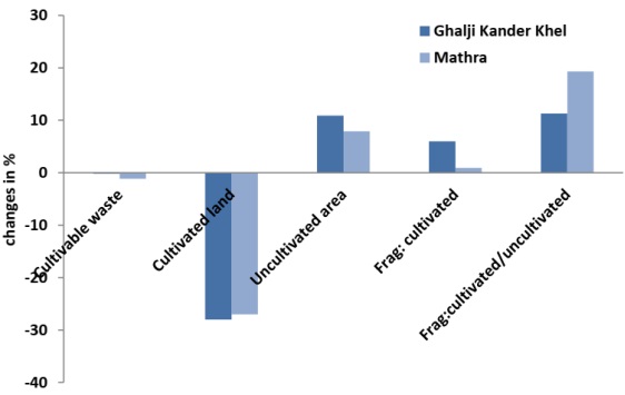
Figure 18:Land Use Analysis in selected Villages, 1990-91 and 2020-21
Conclusion
The case study of land fragmentation in the village of Mathra and Ghalji Kander Khel indicates that between 1990-1991 and 2020 -21 there was an increase in land fragmentation in both villages. In the research region, there is either fragmented cultivated land or fragmented cultivated/uncultivated land. There is fragmented cultivated land in the village Ghalji Kander Khel and fragmented cultivated/uncultivated land in the village Mathra. This is due to the fast development of Mathra commercial sectors that the land is fragmented into cultivated and uncultivated sections. The fragmentation process has historically been ongoing, and given the present operating environment, it is likely to continue absent appropriate actions to stop it.
The study found that the study area's land is fragmented due to several variables. The two main factors are population growth and inheritance. The number of owners grows along with the population, and according to the inheritance law, the land is to be divided between the inheritors. Because every sort of land must be shared among the heirs, each one only obtains a very little plot, which is likewise spread. Besides this, market values, financial problems, social problems, and government infrastructure were some other factors for rapid land fragmentation. The government should pay proper attention to land fragmentation reduction measurement.
Analysis also showed that in 1990–1991 agricultural land dominated in the selected villages. The built-up area started to grow with time. As the amount of cultivated land decreased, the built-up area of Ghalji Kander Khel and Mathra grew. The cultivable waste was reduced and used for other purposes. According to the report, the decline in cultivable land represents a serious threat to food security, while the uncultivated area has nearly doubled. According to the results of the field survey, the majority of respondents in Village Ghalji Kander Khel stated that their lands were cultivated in 1990–1991 yet their cultivated lands were decreasing and their uncultivated land was increasing by 2020–21.
Acknowledgment:
We acknowledge this work to our supervisors.
Conflict of interest:
The authors declare no conflict of interest for publishing.
Author’s Contribution:
All the authors contributed equally.
Project details:
Nil.
Reference
[1] T. Q. Tran and H. Van Vu, “Land fragmentation and household income: First evidence from rural Vietnam,” Land use policy, vol. 89, p. 104247, Dec. 2019, doi: 10.1016/J.LANDUSEPOL.2019.104247.
[2] T. van Dijk, “Scenarios of Central European land fragmentation,” Land use policy, vol. 20, no. 2, pp. 149–158, Apr. 2003, doi: 10.1016/S0264-8377(02)00082-0.
[3] Y. Jiang, Y. T. Tang, H. Long, and W. Deng, “Land consolidation: A comparative research between Europe and China,” Land use policy, vol. 112, p. 105790, Jan. 2022, doi: 10.1016/J.LANDUSEPOL.2021.105790.
[4] J. Liu et al., “Influential factors and classification of cultivated land fragmentation, and implications for future land consolidation: A case study of Jiangsu Province in eastern China,” Land use policy, vol. 88, p. 104185, Nov. 2019, doi: 10.1016/J.LANDUSEPOL.2019.104185.
[5] R. Kousar, M. S. A. Makhdum, R. Ullah, A. Saghir, S. Usman, and T. Sadaf, “Empirical investigation of impact of land fragmentation on crop productivity in Punjab, Pakistan,” Sarhad J. Agric., vol. 36, no. 1, pp. 217–223, 2020, doi: 10.17582/JOURNAL.SJA/2020/36.1.217.223.
[6] L. Latruffe and L. Piet, “Does land fragmentation affect farm performance? A case study from Brittany, France,” Agric. Syst., vol. 129, pp. 68–80, Jul. 2014, doi: 10.1016/J.AGSY.2014.05.005.
[7] O. L. Balogun and B. E. Akinyemi, “Land fragmentation effects on technical efficiency of cassava farmers in South-West geopolitical zone, Nigeria,” http://www.editorialmanager.com/cogentsocsci, vol. 3, no. 1, p. 1387983, Jan. 2017, doi: 10.1080/23311886.2017.1387983.
[8] R. S. de Groot, R. Alkemade, L. Braat, L. Hein, and L. Willemen, “Challenges in integrating the concept of ecosystem services and values in landscape planning, management and decision making,” Ecol. Complex., vol. 7, no. 3, pp. 260–272, Sep. 2010, doi: 10.1016/J.ECOCOM.2009.10.006.
[9] V. Gitz and A. Meybeck, “Risks, vulnerabilities and resilience in a context of climate change”.
[10] Y. Li, Z. Cao, H. Long, Y. Liu, and W. Li, “Dynamic analysis of ecological environment combined with land cover and NDVI changes and implications for sustainable urban–rural development: The case of Mu Us Sandy Land, China,” J. Clean. Prod., vol. 142, pp. 697–715, Jan. 2017, doi: 10.1016/J.JCLEPRO.2016.09.011.
[11] M. Sajid et al., “IMPACT OF LAND-USE CHANGE ON AGRICULTURAL PRODUCTION & ACCURACY ASSESSMENT THROUGH CONFUSION MATRIX,” Pak. J. Sci., vol. 74, no. 4, Jan. 2022, doi: 10.57041/PJS.V74I4.793.
[12] D. Demetriou, J. Stillwell, and L. See, “A new methodology for measuring land fragmentation,” Comput. Environ. Urban Syst., vol. 39, pp. 71–80, May 2013, doi: 10.1016/J.COMPENVURBSYS.2013.02.001.
[13] J. D. Sachs, G. Schmidt-Traub, M. Mazzucato, D. Messner, N. Nakicenovic, and J. Rockström, “Six Transformations to achieve the Sustainable Development Goals,” Nat. Sustain. 2019 29, vol. 2, no. 9, pp. 805–814, Aug. 2019, doi: 10.1038/s41893-019-0352-9.
[14] Y. Liu, F. Fang, and Y. Li, “Key issues of land use in China and implications for policy making,” Land use policy, vol. 40, pp. 6–12, Sep. 2014, doi: 10.1016/J.LANDUSEPOL.2013.03.013.
[15] P. Van Hung, T. G. Macaulay, and S. P. Marsh, “The economics of land fragmentation in the north of Vietnam*,” Aust. J. Agric. Resour. Econ., vol. 51, no. 2, pp. 195–211, Jun. 2007, doi: 10.1111/J.1467-8489.2007.00378.X.
[16] S. Tan, N. Heerink, and F. Qu, “Land fragmentation and its driving forces in China,” Land use policy, vol. 23, no. 3, pp. 272–285, Jul. 2006, doi: 10.1016/J.LANDUSEPOL.2004.12.001.
[17] G. S. Niroula and G. B. Thapa, “Impacts of land fragmentation on input use, crop yield and production efficiency in the mountains of Nepal,” L. Degrad. Dev., vol. 18, no. 3, pp. 237–248, May 2007, doi: 10.1002/LDR.771.
[18] H. Mäkinen and H. Mäkinen, “Farmers’ managerial thinking and management process effectiveness as factors of financial success on Finnish dairy farms,” Agric. Food Sci., vol. 22, no. 4, pp. 452–465, Dec. 2013, doi: 10.23986/AFSCI.8147.
[19] S. Su, Y. Hu, F. Luo, G. Mai, and Y. Wang, “Farmland fragmentation due to anthropogenic activity in rapidly developing region,” Agric. Syst., vol. 131, pp. 87–93, Nov. 2014, doi: 10.1016/J.AGSY.2014.08.005.
[20] B. N. Dhakal and N. R. Khanal, “Causes and Consequences of Fragmentation of Agricultural Land: A Case of Nawalparasi District, Nepal,” Geogr. J. Nepal, vol. 11, pp. 95–112, Apr. 2018, doi: 10.3126/GJN.V11I0.19551.
[21] J. Janus and E. Ertunç, “Differences in the effectiveness of land consolidation projects in various countries and their causes: Examples of Poland and Turkey,” Land use policy, vol. 108, p. 105542, Sep. 2021, doi: 10.1016/J.LANDUSEPOL.2021.105542.
[22] T. Sikor, D. Müller, and J. Stahl, “Land Fragmentation and Cropland Abandonment in Albania: Implications for the Roles of State and Community in Post-Socialist Land Consolidation,” World Dev., vol. 37, no. 8, pp. 1411–1423, Aug. 2009, doi: 10.1016/J.WORLDDEV.2008.08.013.
[23] M. Atasoy, “Monitoring the urban green spaces and landscape fragmentation using remote sensing: a case study in Osmaniye, Turkey,” Environ. Monit. Assess., vol. 190, no. 12, pp. 1–8, Dec. 2018, doi: 10.1007/S10661-018-7109-1/METRICS.
[24] Z. Wu, R. Chen, M. E. Meadows, D. Sengupta, and D. Xu, “Changing urban green spaces in Shanghai: trends, drivers and policy implications,” Land use policy, vol. 87, p. 104080, Sep. 2019, doi: 10.1016/J.LANDUSEPOL.2019.104080.