This section provides a summary of the selected studies, highlighting their most salient features and findings. These studies employed a wide range of approaches, data sets, and success metrics, providing valuable insights into optimizing deep learning models and multispectral Landsat imagery for this purpose. An understanding of the depth and breadth of the field's study can be gained from reading this summary.
The selected studies utilized various methods to process and analyze Landsat imagery for desertification diagnosis, as dissected in an analysis of multispectral Landsat image analysis techniques. Pre-processing, feature extraction, and classification are just some of the many facets covered by these techniques [98].
Atmospheric correction, radiometric calibration, and geometric correction were used in the pre-processing stages of the research that were chosen. These methods are crucial for improving Landsat image quality and eliminating artifacts or distortions that could compromise the reliability of desertification diagnosis [99].
Selected studies employed feature extraction techniques like texture analysis, spectral signature analysis, and the calculation of vegetation indices (such as NDVI and EVI). Important indications of desertification such as vegetation cover, soil properties, and land surface conditions can be gleaned using these methods [100].
The investigations used a wide variety of classification techniques, including both classic ML algorithms and more recent DL models. Maximum Likelihood, Support Vector Machines, and Random Forests are just a few of the classic techniques that have been utilized in the identification of desertification. Convolutional Neural Networks (CNNs) and Recurrent Neural Networks (RNNs) are two examples of deep learning models that have gained popularity in recent years because of their capacity to automatically learn and extract complicated patterns from Landsat imagery. The strengths and weaknesses of various methods for analyzing multispectral Landsat images are shown, allowing for a comparison of how well they perform in identifying desertification.
Performance and accuracy in identifying desertification are two aspects of deep learning models that are evaluated. Selected studies have used a variety of evaluation criteria to quantify the performance of deep learning models [101], including accuracy, precision, recall, F1-score, and area under the receiver operating characteristic curve.
The evaluation results suggest that deep learning models perform well in identifying desertification. These models successfully capture complex patterns and transitions associated with desertification processes, demonstrating their use in accurately classifying decertified and non-decertified regions. When dealing with complex and varied environments, the use of deep learning models enables increased precision, particularly in complex and varied environments [102].
Furthermore, the evaluation of deep learning models highlights the importance of appropriate training datasets and model fine-tuning. The studies showcased leveraging large-scale and diverse training datasets, along with transfer learning techniques, enhances the generalization and robustness of the models in desertification identification.
Figure 11 displays the geographic distribution of Landsat change detection studies conducted for desertification identification. The map highlights the regions across the globe where these studies have been undertaken, indicating the global relevance and significance of desertification monitoring. Additionally, it highlights the areas of particular concern, such as arid and semi-arid regions, where desertification is a prevalent issue.
Figure 12 illustrates the sources of Landsat data used in change detection studies for desertification identification. The figure shows that the majority of studies rely on Landsat data obtained from various official sources, such as the USGS Earth Explorer or other national data centers. This highlights the wide availability and accessibility of Landsat data for researchers, facilitating global studies on desertification.
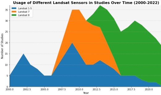
Figure 13 presents the usage of different Landsat sensors over time in desertification identification studies. The figure showcases the evolution of Landsat missions and their contributions to desertification monitoring. Landsat 5 and 7 were widely used in the early years, while Landsat 8 gained prominence in recent years due to its enhanced capabilities, such as improved spatial resolution and additional spectral bands.
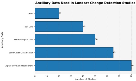
Figure 14 provides an overview of the types of ancillary data integrated into Landsat change detection studies for desertification identification. Ancillary data includes various additional datasets that supplement Landsat imagery to enhance the understanding of desertification processes. Common ancillary data types used in these studies include climate data, socioeconomic data, and high-resolution imagery, allowing researchers to consider multiple factors influencing desertification.
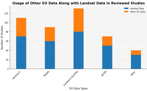
Figure 15 depicts the usage of Earth Observation (EO) data sources in conjunction with Landsat data for desertification identification. This figure demonstrates the integration of diverse EO data, such as Sentinel-2, MODIS, LiDAR, and climate data, to provide a more comprehensive understanding of desertification dynamics. By combining different datasets, researchers gain valuable insights into various aspects of desertification, including land cover changes and vegetation dynamics.
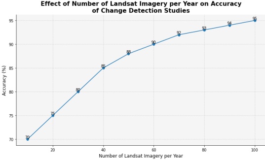
Figure 16 presents the accuracy percentage of studies conducted per year for desertification identification. This figure reflects the performance of various methodologies and models employed in these studies. The increasing trend in accuracy over time suggests advancements in data processing techniques, feature extraction methods, and the use of sophisticated deep learning algorithms, leading to improved identification of desertification patterns.
The analysis of the selected studies revealed several trends and advancements in desertification identification using multispectral Landsat imagery and deep learning models [103][104][105][106][107]. These include:
Many studies have explored the integration of additional data sources, such as climate data, socioeconomic data, and high-resolution imagery, to improve the accuracy and comprehensiveness of desertification identification [89].
The utilization of Landsat time series data and the incorporation of temporal information have become more prevalent, allowing for the detection of long-term trends and changes associated with desertification [90].
Studies have emphasized the importance of considering multiple spatial scales in desertification identification, ranging from local-scale analysis to regional-scale assessments. This acknowledges the heterogeneous nature of desertification processes and the need to capture spatial variations [91].
Transfer learning techniques and deep feature extraction methods have shown significant potential in enhancing the performance of deep learning models in desertification identification. Leveraging pre-trained models and extracting deep features allow for improved generalization and better representation of complex patterns [92]. Desertification identification methods using multispectral Landsat images and deep learning models are continuously being refined to improve their accuracy, efficiency, and application, as seen by the trends and advancements observed in the analysis [93].
Figure 17 presents the trends in pre-processing techniques used in desertification identification studies over time. The figure shows cases of the evolution of pre-processing methods employed to enhance Landsat imagery for accurate desertification detection. It reveals the shift from basic pre-processing techniques in the early years to more sophisticated approaches, such as atmospheric correction, radiometric calibration, and geometric correction, in recent studies. These advanced techniques aim to minimize the impact of atmospheric and radiometric distortions, ensuring the reliability of desertification identification results.
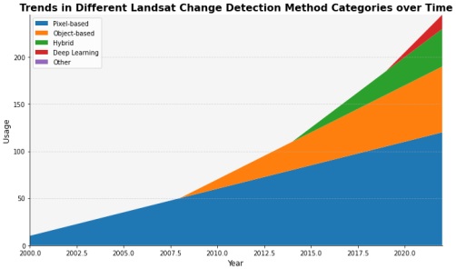
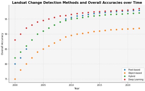
Figure 18 illustrates the trends in Landsat Change Detection methods utilized for desertification identification over time. The figure demonstrates the shift in methodologies from traditional machine learning algorithms, such as Maximum Likelihood and Support Vector Machines, to the increasing popularity of deep learning models like Convolutional Neural Networks (CNNs) and Recurrent Neural Networks (RNNs). This trend highlights the growing recognition of deep learning's ability to automatically learn complex patterns and features from Landsat imagery, leading to improved accuracy in desertification detection.
Figure 19 showcases the improvements in accuracy achieved by various methodologies and models utilized in these studies. As technology advances and researchers refine their approaches, the accuracy of desertification identification increases, providing more reliable and precise assessments of desertification processes.
Despite the advancements made in desertification identification using multispectral Landsat imagery and deep learning models, there are still limitations and challenges that need to be addressed. Some of the limitations include:
Landsat imagery has a moderate spatial resolution of 30 meters, which may not be sufficient to capture small-scale desertification processes and changes. Higher-resolution data sources, such as Sentinel-2 or commercial satellites, can complement Landsat data in capturing fine-scale desertification patterns [93].
The capacity to accurately capture and model these variations is hampered by the geographical and temporal variability of desertification processes. Flexible and dynamic modeling approaches that consider variations in landscape and environmental conditions are needed to address the multifaceted nature of desertification [94][95].
Determining the certainty or uncertainty of desertification identification procedures remains challenging. Validating results can be difficult due to the limitation of ground truth data, particularly in rural and inaccessible places. The reliability of desertification identification results can be increased through the creation of strong validation frameworks and the integration of numerous validation methodologies [96][97].
The precision and dependability of desertification identification are significantly impacted by the availability and quality of data. Problems with data accessibility and quality encompass:
Historical Data Accessibility: For conducting long-term desertification studies, access to historical Landsat data is crucial. Historical data from previous Landsat missions facilitates a more thorough and consistent analysis [29][31][32].
Temporal Resolution and Data Continuity Landsat data may not be able to detect rapid changes in desertification because of its limited temporal resolution (16-day revisit time). More frequent observations and improved monitoring of dynamic desertification processes are possible with the use of data from other satellite missions with higher temporal resolution [41].
Integration and Data Fusion Sentinel-2, MODIS, LiDAR, and climate data are some of the sensors that can be integrated to improve the accuracy and breadth of desertification identification. However, challenges emerge during the fusion and integration of data due to disparities in data types, the absence of standardization, and inadequate processing methods [53].
Future studies should concentrate on combining additional data sources to enhance desertification identification to compensate for the shortcomings of Landsat data. The following are examples of possible data integration sources:
Detailed information on land cover shifts, vegetation dynamics, and soil qualities can be gleaned from high-resolution photography. The accuracy of desertification diagnosis can be improved by combining high-resolution photography with Landsat data, especially in varied areas [59].
Incorporating climate and weather data is essential for understanding the climatic factors and implications on desertification processes can be aided by including climate and weather data. Desertification patterns can be better characterized and predicted by analyzing climate factors including temperature, precipitation, and drought indices [70].
Data from the social sciences shows that understanding the causes and effects of desertification requires looking at things like population growth, land use shifts, and human activities. The social-ecological dynamics of desertification can be better understood by combining socioeconomic data with remote sensing data [10].
There are many potential applications and areas of study for deep learning models trained using Landsat data.
Improved performance and interpretability of deep learning models in desertification identification can be achieved by exploring more advanced deep learning architectures such as attention mechanisms, graph convolutional networks, and transformer-based models [48].
It is critical to create strategies for quantifying and representing the uncertainty in desertification identification outcomes. Bayesian deep learning and ensemble methods are two uncertainty estimation strategies that can shed light on the accuracy and stability of the predictions [19].
Improving deep learning models to explainability and interpretability will help researchers better comprehend the features and patterns underlying desertification identification outcomes. Important aspects and regions contributing to the predictions can be identified and visualized using methods like model interpretability techniques and attention processes [28].
A greater mechanistic knowledge of the processes underlying desertification can be attained through the integration of process-based models like ecosystem models or hydrological models with remote sensing and deep learning technologies. This integration enables the modeling and prediction of future desertification scenarios under diverse environmental and climatic conditions [82].
It is crucial to ensure that generated models may be applied to a variety of settings and contexts. Knowledge and models can be easily transferred to new study areas by developing transfer learning techniques and domain adaption methods, thereby eliminating the need for substantial data gathering and training.
[1] A. Baeza et al., “Long-lasting transition toward sustainable elimination of desert malaria under irrigation development,” Proc. Natl. Acad. Sci. U. S. A., vol. 110, no. 37, pp. 15157–15162, Sep. 2013, doi: 10.1073/PNAS.1305728110/SUPPL_FILE/SAPP.PDF.
[2] L. Radonic, “Re-conceptualising Water Conservation: Rainwater Harvesting in the Desert of the Southwestern United States”, Accessed: Jan. 03, 2024. [Online]. Available: https://www.water-alternatives.org/index.php/alldoc/articles/vol12/v12issue2/499-a12-2-6/file
[3] M. Abdelkareem and N. Al-Arifi, “The use of remotely sensed data to reveal geologic, structural, and hydrologic features and predict potential areas of water resources in arid regions,” Arab. J. Geosci., vol. 14, no. 8, pp. 1–15, Apr. 2021, doi: 10.1007/S12517-021-06942-6/METRICS.
[4] M. E. H. Chowdhury et al., “Design, Construction and Testing of IoT Based Automated Indoor Vertical Hydroponics Farming Test-Bed in Qatar,” Sensors 2020, Vol. 20, Page 5637, vol. 20, no. 19, p. 5637, Oct. 2020, doi: 10.3390/S20195637.
[5] J. Lee and K. Chung, “An Efficient Transmission Power Control Scheme for Temperature Variation in Wireless Sensor Networks,” Sensors 2011, Vol. 11, Pages 3078-3093, vol. 11, no. 3, pp. 3078–3093, Mar. 2011, doi: 10.3390/S110303078.
[6] O. S. Mintaș, D. Mierliță, O. Berchez, A. Stanciu, A. Osiceanu, and A. G. Osiceanu, “Analysis of the Sustainability of Livestock Farms in the Area of the Southwest of Bihor County to Climate Change,” Sustain. 2022, Vol. 14, Page 8841, vol. 14, no. 14, p. 8841, Jul. 2022, doi: 10.3390/SU14148841.
[7] P. Roy, “FOREST FIRE AND DEGRADATION ASSESSMENT USING SATELLITE REMOTE SENSING AND GEOGRAPHIC INFORMATION SYSTEM,” 2005, Accessed: Jan. 03, 2024. [Online]. Available: https://www.semanticscholar.org/paper/FOREST-FIRE-AND-DEGRADATION-ASSESSMENT-USING-REMOTE-Roy/a3ce1dff2fe6e1a5eb81eb5473b5e1114b9cd655
[8] J. E. Lovich and J. R. Ennen, “Wildlife Conservation and Solar Energy Development in the Desert Southwest, United States,” Bioscience, vol. 61, no. 12, pp. 982–992, Dec. 2011, doi: 10.1525/BIO.2011.61.12.8.
[9] “Sustainable agriculture and climate change An ActionAid rough guide Sustainable agriculture and climate change,” 2009, Accessed: Jan. 03, 2024. [Online]. Available: http://www.agassessment.org/
[10] M. Belloumi, “Investigating the Impact of Climate Change on Agricultural Production in Eastern and Southern African Countries,” 2014, Accessed: Jan. 03, 2024. [Online]. Available: https://www.agrodep.org/sites/default/files/AGRODEPWP0003.pdf
[11] M. Fujioka, “Mate and Nestling Desertion in Colonial Little Egrets,” Auk, vol. 106, no. 2, pp. 292–302, Apr. 1989, doi: 10.1093/AUK/106.2.292.
[12] “Silent revolution through climate smart livestock farming in cold desert.” Accessed: Jan. 03, 2024. [Online]. Available: https://www.researchgate.net/publication/322298175_Silent_revolution_through_climate_smart_livestock_farming_in_cold_desert
[13] D. Kushner, “The real story of stuxnet,” IEEE Spectr., vol. 50, no. 3, pp. 48–53, 2013, doi: 10.1109/MSPEC.2013.6471059.
[14] K. M. R. Hunt, A. G. Turner, and L. C. Shaffrey, “Extreme Daily Rainfall in Pakistan and North India: Scale Interactions, Mechanisms, and Precursors,” Mon. Weather Rev., vol. 146, no. 4, pp. 1005–1022, Apr. 2018, doi: 10.1175/MWR-D-17-0258.1.
[15] A. M. Hay, “The derivation of global estimates from a confusion matrix,” Int. J. Remote Sens., vol. 9, no. 8, pp. 1395–1398, 1988, doi: 10.1080/01431168808954945.
[16] H. Gao, Z. Chen, and C. Li, “Sandwich Convolutional Neural Network for Hyperspectral Image Classification Using Spectral Feature Enhancement,” IEEE J. Sel. Top. Appl. Earth Obs. Remote Sens., vol. 14, pp. 3006–3015, 2021, doi: 10.1109/JSTARS.2021.3062872.
[17] X. Yang, Y. Ye, X. Li, R. Y. K. Lau, X. Zhang, and X. Huang, “Hyperspectral image classification with deep learning models,” IEEE Trans. Geosci. Remote Sens., vol. 56, no. 9, pp. 5408–5423, Sep. 2018, doi: 10.1109/TGRS.2018.2815613.
[18] J. Abdulridha, R. Ehsani, A. Abd-Elrahman, and Y. Ampatzidis, “A remote sensing technique for detecting laurel wilt disease in avocado in presence of other biotic and abiotic stresses,” Comput. Electron. Agric., vol. 156, pp. 549–557, Jan. 2019, doi: 10.1016/J.COMPAG.2018.12.018.
[19] Q. Meng, X. Wen, L. Yuan, and H. Xu, “Factorization-Based Active Contour for Water-Land SAR Image Segmentation via the Fusion of Features,” IEEE Access, vol. 7, pp. 40347–40358, 2019, doi: 10.1109/ACCESS.2019.2905847.
[20] C. Wu and X. Zhang, “Total Bregman divergence-based fuzzy local information C-means clustering for robust image segmentation,” Appl. Soft Comput., vol. 94, p. 106468, Sep. 2020, doi: 10.1016/J.ASOC.2020.106468.
[21] P. Xiao, X. Tian, M. Liu, and W. Liu, “Multipath Smearing Suppression for Synthetic Aperture Radar Images of Harbor Scenes,” IEEE Access, vol. 7, pp. 20150–20162, 2019, doi: 10.1109/ACCESS.2019.2897779.
[22] A. Asokan, J. Anitha, B. Patrut, D. Danciulescu, and D. J. Hemanth, “Deep Feature Extraction and Feature Fusion for Bi-Temporal Satellite Image Classification,” Comput. Mater. Contin., vol. 66, no. 1, pp. 373–388, Oct. 2020, doi: 10.32604/CMC.2020.012364.
[23] D. Liu, F. Yang, H. Wei, and P. Hu, “Remote sensing image fusion method based on discrete wavelet and multiscale morphological transform in the IHS color space,” https://doi.org/10.1117/1.JRS.14.016518, vol. 14, no. 1, p. 016518, Mar. 2020, doi: 10.1117/1.JRS.14.016518.
[24] “Master Thesis Tree Detection in Remote Sensing Imagery Baumerkennung in FernerkundungsBildmaterial”, [Online]. Available: https://www.uni-goettingen.de/de/document/download/e3004c6e53ca2fa0a30d53d98a52c24e.pdf/MA_Freudenberg.pdf
[25] L. Costa, S. Kunwar, Y. Ampatzidis, and U. Albrecht, “Determining leaf nutrient concentrations in citrus trees using UAV imagery and machine learning,” Precis. Agric., vol. 23, no. 3, pp. 854–875, Jun. 2022, doi: 10.1007/S11119-021-09864-1/FIGURES/10.
[26] J. Zhang, “Multi-source remote sensing data fusion: status and trends,” Int. J. Image Data Fusion, vol. 1, no. 1, pp. 5–24, 2010, doi: 10.1080/19479830903561035.
[27] Y. Qian, M. Ye, and J. Zhou, “Hyperspectral image classification based on structured sparse logistic regression and three-dimensional wavelet texture features,” IEEE Trans. Geosci. Remote Sens., vol. 51, no. 4, pp. 2276–2291, 2013, doi: 10.1109/TGRS.2012.2209657.
[28] S. Jozdani, D. Chen, D. Pouliot, and B. Alan Johnson, “A review and meta-analysis of Generative Adversarial Networks and their applications in remote sensing,” Int. J. Appl. Earth Obs. Geoinf., vol. 108, p. 102734, Apr. 2022, doi: 10.1016/J.JAG.2022.102734.
[29] A. A. Sima and S. J. Buckley, “Optimizing SIFT for Matching of Short Wave Infrared and Visible Wavelength Images,” Remote Sens. 2013, Vol. 5, Pages 2037-2056, vol. 5, no. 5, pp. 2037–2056, Apr. 2013, doi: 10.3390/RS5052037.
[30] T. Zhao, Y. Yang, H. Niu, D. Wang, and Y. Chen, “Comparing U-Net convolutional network with mask R-CNN in the performances of pomegranate tree canopy segmentation,” https://doi.org/10.1117/12.2325570, vol. 10780, pp. 210–218, Oct. 2018, doi: 10.1117/12.2325570.
[31] Y. Lu, “Deep Learning for Remote Sensing Image Processing,” Comput. Model. Simul. Eng. Theses Diss., Aug. 2020, doi: 10.25777/9nwb-h685.
[32] R. Kemker, C. Salvaggio, and C. Kanan, “Algorithms for semantic segmentation of multispectral remote sensing imagery using deep learning,” ISPRS J. Photogramm. Remote Sens., vol. 145, pp. 60–77, Nov. 2018, doi: 10.1016/J.ISPRSJPRS.2018.04.014.
[33] P. Iyer, S. A, and S. Lal, “Deep learning ensemble method for classification of satellite hyperspectral images,” Remote Sens. Appl. Soc. Environ., vol. 23, p. 100580, Aug. 2021, doi: 10.1016/J.RSASE.2021.100580.
[34] S. Malek, “Deep neural network models for image classification and regression,” May 2018.
[35] S. Janarthanan, T. Ganesh Kumar, S. Janakiraman, R. K. Dhanaraj, and M. A. Shah, “An Efficient Multispectral Image Classification and Optimization Using Remote Sensing Data,” J. Sensors, vol. 2022, 2022, doi: 10.1155/2022/2004716.
[36] R. Minetto, M. P. Segundo, G. Rotich, and S. Sarkar, “Measuring human and economic activity from satellite imagery to support city-scale decision-making during COVID-19 pandemic,” IEEE Trans. Big Data, vol. 7, no. 1, pp. 56–68, Mar. 2021, doi: 10.1109/TBDATA.2020.3032839.
[37] “Mapping and classification of urban green spaces with object based image analysis and LiDAR data fusion.” Accessed: Jan. 03, 2024. [Online]. Available: https://sci-hub.se/10.4314/jfas.v10i1s.7
[38] Y. Li, H. Zhang, X. Xue, Y. Jiang, and Q. Shen, “Deep learning for remote sensing image classification: A survey,” Wiley Interdiscip. Rev. Data Min. Knowl. Discov., vol. 8, no. 6, p. e1264, Nov. 2018, doi: 10.1002/WIDM.1264.
[39] N. Laban, B. Abdellatif, H. M. Ebied, H. A. Shedeed, and M. F. Tolba, “Multiscale satellite image classification using deep learning approach,” Stud. Comput. Intell., vol. 836, pp. 165–186, 2020, doi: 10.1007/978-3-030-20212-5_9/COVER.
[40] B. Trenčanová, V. Proença, and A. Bernardino, “Development of Semantic Maps of Vegetation Cover from UAV Images to Support Planning and Management in Fine-Grained Fire-Prone Landscapes,” Remote Sens. 2022, Vol. 14, Page 1262, vol. 14, no. 5, p. 1262, Mar. 2022, doi: 10.3390/RS14051262.
[41] R. Goldblatt et al., “Using Landsat and nighttime lights for supervised pixel-based image classification of urban land cover,” Remote Sens. Environ., vol. 205, pp. 253–275, Feb. 2018, doi: 10.1016/J.RSE.2017.11.026.
[42] B. Benjdira, Y. Bazi, A. Koubaa, and K. Ouni, “Unsupervised Domain Adaptation Using Generative Adversarial Networks for Semantic Segmentation of Aerial Images,” Remote Sens. 2019, Vol. 11, Page 1369, vol. 11, no. 11, p. 1369, Jun. 2019, doi: 10.3390/RS11111369.
[43] Y. Chen, H. Jiang, C. Li, X. Jia, and P. Ghamisi, “Deep Feature Extraction and Classification of Hyperspectral Images Based on Convolutional Neural Networks,” IEEE Trans. Geosci. Remote Sens., vol. 54, no. 10, pp. 6232–6251, Oct. 2016, doi: 10.1109/TGRS.2016.2584107.
[44] W. Ding and L. Zhang, “Building Detection in Remote Sensing Image Based on Improved YOLOV5,” Proc. - 2021 17th Int. Conf. Comput. Intell. Secur. CIS 2021, pp. 133–136, 2021, doi: 10.1109/CIS54983.2021.00036.
[45] X. Li et al., “Prediction of Forest Fire Spread Rate Using UAV Images and an LSTM Model Considering the Interaction between Fire and Wind,” Remote Sens. 2021, Vol. 13, Page 4325, vol. 13, no. 21, p. 4325, Oct. 2021, doi: 10.3390/RS13214325.
[46] H. Zhang, G. R. Arce, X. Zhao, and X. Ma, “Compressive hyperspectral image classification using a 3D coded convolutional neural network,” Opt. Express, Vol. 29, Issue 21, pp. 32875-32891, vol. 29, no. 21, pp. 32875–32891, Oct. 2021, doi: 10.1364/OE.437717.
[47] Q. Gao, S. Lim, and X. Jia, “Hyperspectral Image Classification Using Convolutional Neural Networks and Multiple Feature Learning,” Remote Sens. 2018, Vol. 10, Page 299, vol. 10, no. 2, p. 299, Feb. 2018, doi: 10.3390/RS10020299.
[48] F. H. Wagner, R. Dalagnol, Y. Tarabalka, T. Y. F. Segantine, R. Thomé, and M. C. M. Hirye, “U-Net-Id, an Instance Segmentation Model for Building Extraction from Satellite Images—Case Study in the Joanópolis City, Brazil,” Remote Sens. 2020, Vol. 12, Page 1544, vol. 12, no. 10, p. 1544, May 2020, doi: 10.3390/RS12101544.
[49] S. S. Panda, D. P. Ames, and S. Panigrahi, “Application of Vegetation Indices for Agricultural Crop Yield Prediction Using Neural Network Techniques,” Remote Sens. 2010, Vol. 2, Pages 673-696, vol. 2, no. 3, pp. 673–696, Mar. 2010, doi: 10.3390/RS2030673.
[50] R. L. Lawrence and A. Wrlght, “Rule-Based Classification Systems Using Classification and Regression Tree (CART) Analysis”.
[51] J. Heikkonen, P. Jafarzadeh, Q. Zhou, and C. Yu, “Point RCNN: An Angle-Free Framework for Rotated Object Detection,” Remote Sens. 2022, Vol. 14, Page 2605, vol. 14, no. 11, p. 2605, May 2022, doi: 10.3390/RS14112605.
[52] V. M. Sekhar and C. S. Kumar, “Laplacian: Reversible Data Hiding Technique,” Proc. IEEE Int. Conf. Image Inf. Process., vol. 2019-November, pp. 546–551, Nov. 2019, doi: 10.1109/ICIIP47207.2019.8985808.
[53] M. Barbouchi, R. Abdelfattah, K. Chokmani, N. Ben Aissa, R. Lhissou, and A. El Harti, “Soil Salinity Characterization Using Polarimetric InSAR Coherence: Case Studies in Tunisia and Morocco,” IEEE J. Sel. Top. Appl. Earth Obs. Remote Sens., vol. 8, no. 8, pp. 3823–3832, Aug. 2015, doi: 10.1109/JSTARS.2014.2333535.
[54] O. Tasar, S. L. Happy, Y. Tarabalka, and P. Alliez, “ColorMapGAN: Unsupervised Domain Adaptation for Semantic Segmentation Using Color Mapping Generative Adversarial Networks,” IEEE Trans. Geosci. Remote Sens., vol. 58, no. 10, pp. 7178–7193, Oct. 2020, doi: 10.1109/TGRS.2020.2980417.
[55] J. Li, B. Liang, and Y. Wang, “A hybrid neural network for hyperspectral image classification,” Remote Sens. Lett., vol. 11, no. 1, pp. 96–105, Jan. 2020, doi: 10.1080/2150704X.2019.1686780.
[56] L. Knopp, M. Wieland, M. Rättich, and S. Martinis, “A Deep Learning Approach for Burned Area Segmentation with Sentinel-2 Data,” Remote Sens. 2020, Vol. 12, Page 2422, vol. 12, no. 15, p. 2422, Jul. 2020, doi: 10.3390/RS12152422.
[57] D. T. Meshesha and M. Abeje, “Developing crop yield forecasting models for four major Ethiopian agricultural commodities,” Remote Sens. Appl. Soc. Environ., vol. 11, pp. 83–93, Aug. 2018, doi: 10.1016/J.RSASE.2018.05.001.
[58] T. Nishio, Y. Koda, J. Park, M. Bennis, and K. Doppler, “When Wireless Communications Meet Computer Vision in beyond 5G,” IEEE Commun. Stand. Mag., vol. 5, no. 2, pp. 76–83, Jun. 2021, doi: 10.1109/MCOMSTD.001.2000047.
[59] Y. Lan, C. Shengde, and B. K. Fritz, “Current status and future trends of precision agricultural aviation technologies,” Int. J. Agric. Biol. Eng., vol. 10, no. 3, pp. 1–17, May 2017, doi: 10.25165/IJABE.V10I3.3088.
[60] Y. Tian, G. Pan, and M. S. Alouini, “Applying Deep-Learning-Based Computer Vision to Wireless Communications: Methodologies, Opportunities, and Challenges,” IEEE Open J. Commun. Soc., vol. 2, pp. 132–143, 2021, doi: 10.1109/OJCOMS.2020.3042630.
[61] W. Yao, Z. Zeng, C. Lian, and H. Tang, “Pixel-wise regression using U-Net and its application on pansharpening,” Neurocomputing, vol. 312, pp. 364–371, Oct. 2018, doi: 10.1016/J.NEUCOM.2018.05.103.
[62] J. Ai, L. Yang, Y. Liu, K. Yu, and J. Liu, “Dynamic Landscape Fragmentation and the Driving Forces on Haitan Island, China,” L. 2022, Vol. 11, Page 136, vol. 11, no. 1, p. 136, Jan. 2022, doi: 10.3390/LAND11010136.
[63] U. Shafi, R. Mumtaz, J. García-Nieto, S. A. Hassan, S. A. R. Zaidi, and N. Iqbal, “Precision Agriculture Techniques and Practices: From Considerations to Applications,” Sensors 2019, Vol. 19, Page 3796, vol. 19, no. 17, p. 3796, Sep. 2019, doi: 10.3390/S19173796.
[64] M. Hameed et al., “Urbanization Detection Using LiDAR-Based Remote Sensing Images of Azad Kashmir Using Novel 3D CNNs,” J. Sensors, vol. 2022, 2022, doi: 10.1155/2022/6430120.
[65] “TEMPORAL CHANGE DETECTION OF LAND USE/LAND COVER USING GIS AND REMOTE SENSING TECHNIQUES IN SOUTH GHOR REGIONS, AL-KARAK, JORDAN”, [Online]. Available: https://sci-hub.se/10.4314/jfas.v10i1s.7
[66] D. Gao, Q. Sun, B. Hu, and S. Zhang, “A Framework for Agricultural Pest and Disease Monitoring Based on Internet-of-Things and Unmanned Aerial Vehicles,” Sensors 2020, Vol. 20, Page 1487, vol. 20, no. 5, p. 1487, Mar. 2020, doi: 10.3390/S20051487.
[67] S. T. Seydi, V. Saeidi, B. Kalantar, N. Ueda, and A. A. Halin, “Fire-Net: A Deep Learning Framework for Active Forest Fire Detection,” J. Sensors, vol. 2022, 2022, doi: 10.1155/2022/8044390.
[68] M. Ahangarha, R. Shah-Hosseini, and M. Saadatseresht, “Deep Learning-Based Change Detection Method for Environmental Change Monitoring Using Sentinel-2 Datasets,” Environ. Sci. Proc. 2021, Vol. 5, Page 15, vol. 5, no. 1, p. 15, Nov. 2020, doi: 10.3390/IECG2020-08544.
[69] K. K. Patel, A. Kar, S. N. Jha, and M. A. Khan, “Machine vision system: A tool for quality inspection of food and agricultural products,” J. Food Sci. Technol., vol. 49, no. 2, pp. 123–141, Apr. 2012, doi: 10.1007/S13197-011-0321-4/METRICS.
[70] T. Brosnan and D. W. Sun, “Improving quality inspection of food products by computer vision––a review,” J. Food Eng., vol. 61, no. 1, pp. 3–16, Jan. 2004, doi: 10.1016/S0260-8774(03)00183-3.
[71] S. Xu, J. Wang, W. Shou, T. Ngo, A. M. Sadick, and X. Wang, “Computer Vision Techniques in Construction: A Critical Review,” Arch. Comput. Methods Eng. 2020 285, vol. 28, no. 5, pp. 3383–3397, Oct. 2020, doi: 10.1007/S11831-020-09504-3.
[72] S. Du et al., “Controllable Image Captioning with Feature Refinement and Multilayer Fusion,” Appl. Sci. 2023, Vol. 13, Page 5020, vol. 13, no. 8, p. 5020, Apr. 2023, doi: 10.3390/APP13085020.
[73] H. Waheed, N. Zafar, W. Akram, A. Manzoor, A. Gani, and S. U. Islam, “Deep Learning Based Disease, Pest Pattern and Nutritional Deficiency Detection System for ‘Zingiberaceae’ Crop,” Agric. 2022, Vol. 12, Page 742, vol. 12, no. 6, p. 742, May 2022, doi: 10.3390/AGRICULTURE12060742.
[74] L. W. Kuswidiyanto, H. H. Noh, and X. Han, “Plant Disease Diagnosis Using Deep Learning Based on Aerial Hyperspectral Images: A Review,” Remote Sens. 2022, Vol. 14, Page 6031, vol. 14, no. 23, p. 6031, Nov. 2022, doi: 10.3390/RS14236031.
[75] M. Z. Hossain, F. Sohel, M. F. Shiratuddin, H. Laga, and M. Bennamoun, “Text to Image Synthesis for Improved Image Captioning,” IEEE Access, vol. 9, pp. 64918–64928, 2021, doi: 10.1109/ACCESS.2021.3075579.
[76] J. R. E. Jeffrey E. Lovich, “Wildlife Conservation and Solar Energy Development in the Desert Southwest, United States”, [Online]. Available: https://academic.oup.com/bioscience/article/61/12/982/392612
[77] B. Zhu et al., “Gradient Structure Information-Guided Attention Generative Adversarial Networks for Remote Sensing Image Generation,” Remote Sens. 2023, Vol. 15, Page 2827, vol. 15, no. 11, p. 2827, May 2023, doi: 10.3390/RS15112827.
[78] M. E. Paoletti, J. M. Haut, J. Plaza, and A. Plaza, “Deep learning classifiers for hyperspectral imaging: A review,” ISPRS J. Photogramm. Remote Sens., vol. 158, pp. 279–317, Dec. 2019, doi: 10.1016/J.ISPRSJPRS.2019.09.006.
[79] K. M. and J. N. Ng’ombe, “Climate Change Impacts on Sustainable Maize Production in Sub-Saharan Africa: A Review”, [Online]. Available: https://www.intechopen.com/chapters/70098
[80] “Water Extraction in SAR Images Using Features Analysis and Dual-Threshold Graph Cut Model”, [Online]. Available: https://www.mdpi.com/2072-4292/13/17/3465
[81] A. A. Sima and S. J. Buckley, “Optimizing SIFT for Matching of Short Wave Infrared and Visible Wavelength Images,” Remote Sens. 2013, Vol. 5, Pages 2037-2056, vol. 5, no. 5, pp. 2037–2056, Apr. 2013, doi: 10.3390/RS5052037.
[82] K. Zhang et al., “Panchromatic and multispectral image fusion for remote sensing and earth observation: Concepts, taxonomy, literature review, evaluation methodologies and challenges ahead,” Inf. Fusion, vol. 93, pp. 227–242, May 2023, doi: 10.1016/J.INFFUS.2022.12.026.
[83] “Mapping and classification of urban green spaces with object based image analysis and LiDAR data fusion.” Accessed: Jan. 03, 2024. [Online]. Available: https://helda.helsinki.fi/items/082da038-fb48-4a9c-bb85-b4a89cad0c96
[84] V. G. Narendra and K. S. Hareesh, “Quality Inspection and Grading of Agricultural and Food Products by Computer Vision-a Review,” Int. J. Comput. Appl., vol. 2, no. 1, pp. 43–65, May 2010, doi: 10.5120/612-863.
[85] J. Cui, “Computer Artificial Intelligence Technology in the Visual Transmission System of Urban Lake Water Quality Inspection and Detection Images,” Wirel. Commun. Mob. Comput., vol. 2022, 2022, doi: 10.1155/2022/2119505.
[86] K. Mulungu, J. N. Ng’ombe, K. Mulungu, and J. N. Ng’ombe, “Climate Change Impacts on Sustainable Maize Production in Sub-Saharan Africa: A Review,” Maize - Prod. Use, Nov. 2019, doi: 10.5772/INTECHOPEN.90033.
[87] A. Voulodimos, N. Doulamis, A. Doulamis, and E. Protopapadakis, “Deep Learning for Computer Vision: A Brief Review,” Comput. Intell. Neurosci., vol. 2018, 2018, doi: 10.1155/2018/7068349.
[88] D. Merkle and M. Middendorf, “Swarm intelligence,” Search Methodol. Introd. Tutorials Optim. Decis. Support Tech., pp. 401–435, 2005, doi: 10.1007/0-387-28356-0_14/COVER.
[89] O. Coban, G. B. de Deyn, and M. van der Ploeg, “Soil microbiota as game-changers in restoration of degraded lands,” Science (80-. )., vol. 375, no. 6584, Mar. 2022, doi: 10.1126/SCIENCE.ABE0725/ASSET/87962C22-9471-4ED5-A872-9CB734500694/ASSETS/IMAGES/LARGE/SCIENCE.ABE0725-F4.JPG.
[90] G. Shi, Y. Wu, T. Li, Q. Fu, and Y. Wei, “Mid- and long-term effects of biochar on soil improvement and soil erosion control of sloping farmland in a black soil region, China,” J. Environ. Manage., vol. 320, p. 115902, Oct. 2022, doi: 10.1016/J.JENVMAN.2022.115902.
[91] X. Wang, L. Wang, S. Li, Z. Wang, M. Zheng, and K. Song, “Remote estimates of soil organic carbon using multi-temporal synthetic images and the probability hybrid model,” Geoderma, vol. 425, p. 116066, Nov. 2022, doi: 10.1016/J.GEODERMA.2022.116066.
[92] L. Duarte, M. Cunha, and A. C. Teodoro, “Comparing Hydric Erosion Soil Loss Models in Rainy Mountainous and Dry Flat Regions in Portugal,” L. 2021, Vol. 10, Page 554, vol. 10, no. 6, p. 554, May 2021, doi: 10.3390/LAND10060554.
[93] A. B. McBratney, M. L. Mendonça Santos, and B. Minasny, “On digital soil mapping,” Geoderma, vol. 117, no. 1–2, pp. 3–52, Nov. 2003, doi: 10.1016/S0016-7061(03)00223-4.
[94] P. A. Sanchez et al., “Digital soil map of the world,” Science (80-. )., vol. 325, no. 5941, pp. 680–681, Aug. 2009, doi: 10.1126/SCIENCE.1175084/SUPPL_FILE/SANCHEZ.SOM.REVISION1.PDF.
[95] B. Minasny and A. B. McBratney, “Digital soil mapping: A brief history and some lessons,” Geoderma, vol. 264, pp. 301–311, Feb. 2016, doi: 10.1016/J.GEODERMA.2015.07.017.
[96] J. Padarian, B. Minasny, and A. B. McBratney, “Machine learning and soil sciences: A review aided by machine learning tools,” SOIL, vol. 6, no. 1, pp. 35–52, Feb. 2020, doi: 10.5194/SOIL-6-35-2020.
[97] Y. Zhou, W. Wu, H. Wang, X. Zhang, C. Yang, and H. Liu, “Identification of Soil Texture Classes Under Vegetation Cover Based on Sentinel-2 Data With SVM and SHAP Techniques,” IEEE J. Sel. Top. Appl. Earth Obs. Remote Sens., vol. 15, pp. 3758–3770, 2022, doi: 10.1109/JSTARS.2022.3164140.
[98] J. D. D. Jayaseeli and D. Malathi, “An Efficient Automated Road Region Extraction from High Resolution Satellite Images using Improved Cuckoo Search with Multi-Level Thresholding Schema,” Procedia Comput. Sci., vol. 167, pp. 1161–1170, Jan. 2020, doi: 10.1016/J.PROCS.2020.03.418.
[99] M. E. Paoletti, J. M. Haut, J. Plaza, and A. Plaza, “A new deep convolutional neural network for fast hyperspectral image classification,” ISPRS J. Photogramm. Remote Sens., vol. 145, pp. 120–147, Nov. 2018, doi: 10.1016/J.ISPRSJPRS.2017.11.021.
[100] M. Shoaib et al., “An advanced deep learning models-based plant disease detection: A review of recent research,” Front. Plant Sci., vol. 14, p. 1158933, Mar. 2023, doi: 10.3389/FPLS.2023.1158933/BIBTEX.
[101] R. Chin, C. Catal, and A. Kassahun, “Plant disease detection using drones in precision agriculture,” Precis. Agric., vol. 24, no. 5, pp. 1663–1682, Oct. 2023, doi: 10.1007/S11119-023-10014-Y/TABLES/8.
[102] R. Sathyavani, K. Jaganmohan, and B. Kalaavathi, “SAILFISH OPTIMIZATION ALGORITHM WITH DEEP CONVOLUTIONAL NEURAL NETWORK FOR NUTRIENT DEFICIENCY DETECTION IN RICE PLANTS,” J. Pharm. Negat. Results, vol. 14, pp. 1713–1728, Jan. 2023, doi: 10.47750/PNR.2023.14.02.217.
[103] M. Khalid, M. S. Sarfraz, U. Iqbal, M. U. Aftab, G. Niedbała, and H. T. Rauf, “Real-Time Plant Health Detection Using Deep Convolutional Neural Networks,” Agric. 2023, Vol. 13, Page 510, vol. 13, no. 2, p. 510, Feb. 2023, doi: 10.3390/AGRICULTURE13020510.
[104] D. Kumar and D. Kumar, “Hyperspectral Image Classification Using Deep Learning Models: A Review,” J. Phys. Conf. Ser., vol. 1950, no. 1, p. 012087, Aug. 2021, doi: 10.1088/1742-6596/1950/1/012087.
[105] S. S. Néia, A. O. Artero, and C. B. Da Cunha, “QUALITY ANALYSIS FOR THE VRP SOLUTIONS USING COMPUTER VISION TECHNIQUES,” Pesqui. Operacional, vol. 37, no. 2, pp. 387–402, May 2017, doi: 10.1590/0101-7438.2017.037.02.0387.
[106] D. Demir et al., “Quality inspection in PCBs and SMDs using computer vision techniques,” IECON Proc. (Industrial Electron. Conf., vol. 2, pp. 857–861, 1994, doi: 10.1109/IECON.1994.397899.
[107] B. Zhang et al., “Principles, developments and applications of computer vision for external quality inspection of fruits and vegetables: A review,” Food Res. Int., vol. 62, pp. 326–343, Aug. 2014, doi: 10.1016/J.FOODRES.2014.03.012.