Appraisal of Deforestation in District Mansehra through Sentinel-2 and Landsat Imagery.
Keywords:
NDVI, Deforestation, Landcover, Afforestation, Optical Imagery.Abstract
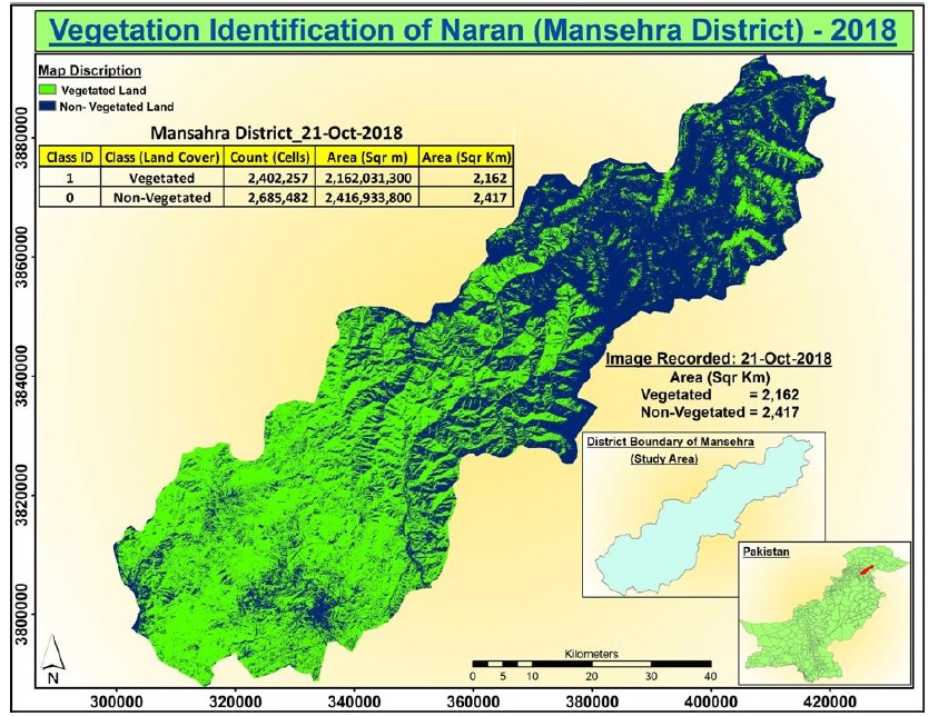
Forests are the main source of food/wood and are important for a healthy environment. Removal of trees from forested landcover is known as deforestation. The main objective of this study was to estimate temporal variations in forested landcover located in district Mansehra for the years from 2008 to 2018 with two comparative time periods 1) 2008 to 2013 and 2) 2013 to 2018. Results indicates about deforestation in the study area during 2008-2013 and afforestation in 2013-2018. Vegetative landcover was increased from 43.3% to 47.2%. Afforestation at tehsil level showed that the vegetative area in Balakot was increased from 26.6% to 29.8%. Similarly, vegetation index increased from 72.2% to 74.42% in Manshera and 82.7% to 83.5% in Oghi. Kappa coefficient performed well to access accuracy of classified imagery which was maximum for the classified map obtained using Sentinel-2 dataset, therefore, Sentinel-2 imagery was proved more reliable in comparison to Landsat imagery. The spectral responses of various land use classes were also mapped which are useful of other researches to recognize features through optical datasets. Results proved the sincere efforts of Khyber Pakhtunkhwa government in promotion of vegetated landcover. The coverage of KPK project must be enhanced for increasing vegetation for a green Pakistan.