
Appraisal of a Running Glacier of Pakistan in Context of Geological Perspectives
Sana Yaqoob Alvi1Abdul baqi2 Ali Abbas2
1Institute of social and cultural studies, University of the Punjab
2 Institute of social and cultural studies, University of the Punjab
3 Department of Geography, University of the Punjab
Correspondence: Sana Yaqoob Alvi, Sanaalvi512@gmail.com
Citation |Alvi.S.Y, Abbas. A “Appraisal of a running glacier of Pakistan in context of geological perspectives”. International Journal of Innovations in Science & Technology, Vol 03 Issue 01: pp 16-23, 2021.
Received |Jan 16, 2021; Revised | Jan 30, 2021; Accepted | Feb 08, 2021; Published | Feb 10, 2021.
___________________________________________________________________
Abstract
Shishper glacier is surge type glacier which gave rise to Glacier Lake Outbursts Flood (GLOF) and an ice dammed lake. The probability of GLOF events has been increased in Pakistan’s mountain system due to increased temperature and irregular glacial fluctuations in northern region of Pakistan. The average rise of temperature in Pakistan is 1.04 ◦C from the year 1960 to 2014. Rising temperature is initiating the recession of glaciers over the last decade which is indicating towards the evolution of glacial lakes in Basin of Hunza River. The Shishper glacier has travelled 800m during six months and about 1400m in the next six months in the year 2018. Shishper glacier has created a danger to infrastructure of downstream of Hassanabad valley situated just below the hill. It travelled about 2.2km during 12 months. Temporal satellite imagery was used to evaluate susceptibility of GLOF events. Digital Elevation model was used to evaluate drainage patterns of Shishper glacier. Geological maps evaluated the geo-refred fault lines in the mountainous regions of Pakistan.
Keywords:Outbursts susceptibility; glacial lake; Digital Elevation model ; GLOF; Hunza River Basin
INTRODUCTION
The main incentive behind the evolution and extension of glacial lakes is the changing climate. The average rise of temperature in Pakistan is 1.04 ◦C from the year 1960 to 2019[1]. According to Pakistan Meteorological Department (PDM), the temperature raised up to 0.8 ◦C in northern areas while the rise in southern areas was observed up to 0.6 ◦C in from year 1900 to 2000 [2] which is an alarming situation. Representative Concentration Pathway(RCP) indicated worst climatic change at global level which projects that a rise in temperature will occur up to 4.8 ◦C by the end of 21thcentury [3]. Thus, the northern areas of Pakistan are more vulnerable to climatic change. The maximum rise in temperature was observed up to 1.79 ◦C in winter in upper Indus Basin from the year 1967 to 2005 while an annual fluctuation of 0.04 ◦C was recorded[4].About 44.02% decline in glacial volume was recorded in the Hunza River Basin in 1989 while a decline of 34.99% was recorded in the year 2010 [5]. Rising temperature is initiating the recession of glaciers over the last decade which is indicating towards the evolution of glacial lakes in Hunza River [6].
These mountainous regions are destabilized and have become susceptible because of different anthropogenic and socio economic activities [7]. Nearly 36 out of 3044 glacial lakes were identified as critical risk [8] which cannot be estimatedby standard statistical methods. Glacial lacks are monitored and assessed temporally and spatially using remote sensing techniques, which are used to observe harsh climatic changes for the collection of data over mountains [9].
The probability of GLOFs is increased by glacier fluctuations caused by changing climate which led to the development and growth of glacial lakes. Thus, data is required for the analysis of water management for glacial lake andmanagement of GLOFs[10].
Nearly 36 glacial lakes are tantamount to flood outbursts due to high GLOF probability especially, rapid climatic changes result in melting of glaciers, threatening the downstream infrastructure [11]. The status of glacial lakes is fluctuating according to the varying GLOF events. The fluctuations in these lakes may be unexpected and irregular. Surging glaciers are disastrous for downstream mountainous communities which are at a high flood risk [12].
This research was conducted to appraise the main response behind the running Shishper Glacier by incorporating local geology, hydrology and slop gradients.
Material and Methods
Study Area
This area under investigation lies within Karakoram Rangebounded bylatitudes 36◦32–37◦05N, 74◦02–75◦48E (Figure1). Hunzariver is known for the high frequency mountains and glaciers. Theseglaciers are located at 7850 m above the sea level [13].
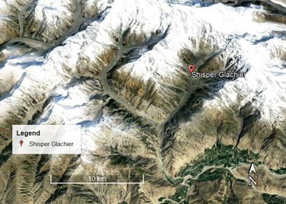
Figure 1. A 3D profile of study site.
Bedrock Geology and Tectonics
The Northern region of Karakoram exhibits complex geography which is appropriate for comprehensive study. The Reshun fault is located at 200 km in east with upper Hunza fault in Chitral which shows its progression along the tectonic structures located in the upper Chupurson valley [14,15,16].
The flow of methodology adopted to accomplish this research is as below,

Figure 2. The flow of methodology.
Geography and Glaciers
Nearly 13,730 km2 region is covered by Hunza river basin which cover almost 30% of this area. Hunza river receive penalty of water due to melting of glaciers located at highest altitude of Hunzariver in Khunjrab valley besides Kashgar of China [17]. At the middle altitude, two main streams (e.g., Misgar and Chupurson) of Ziarat contributes melt-water to Hunza River followed by Shimshal stream [18]. At the lowest altitude, tributaries of the Shishper glacier cause to add melted-water into the Hunzariver. The melted-water is used by the downstream population of Pakistan for irrigation, energy production and drinking [19].
Material and Methods
The datasets and their utilization is shown in methodology flow chart. The datasets used in this research paper are of three types 1) Temporal satellite imagery 2) Digital Elevation Model (DEM) of 30m resolution of Astor and 3) Geological Map.
Satellite imagery
The satellite imagery was obtained for the months of Feb, June and December of the year 2018 and of April 2021 to monitor temporal variations in displacement of Shishper glacier. We computed spectral signatures of various existing land use features.
Digital Elevation Model (DEM).
DEM is 3D representationof surface of earth. We obtained DEM of Aster 30m from United State Geological Survey (USGS) website to compute drainage pattern. High drainage density leads to high surface deformation, which are responsible for mass movement of the surface of earth.
Geological Map.
We obtained Geological map and geo-refed it to draw fault lines beneath the study site. These fault lines are responsible for large scale surface deformation of mega structures.
Normalized Difference Snow Index (NDSI).
NDSI is the popular index used to highlight snow among other landuse. The formula to compute NDSI is as below,
NDSI = Green-SWIR/Green+SWIR
Results
Maps of glacier lakes exhibited the inconsistency of distributive features of Shishper glacier concerning the elevation. Roughly 28.23% lakes observed originated from glaciers located above 4500 m whereas altitude of 2000 to 2500 m own larger area of 5.01 km2 locating Attabad lake which incorporate 63.8% of area of all glacial lakes.
Temporal satellite imagery determines that Shishper glacier has travelled 800m during six months and about 1400m in the next six months as shown in figure 3.The spectral signatures of various landuse features were obtained as shown in the figure 3. The NDSI was computed for cross verification of snow extent.

Figure 3. Spatio-temporal variation of displacement of Shisper Glacier and the spectral signature of various landuse features under observation.
The fault lines were extracted from geo-efred geological map to determine the impact of local geology on mass movement, and the results are drawn in the figure 4.
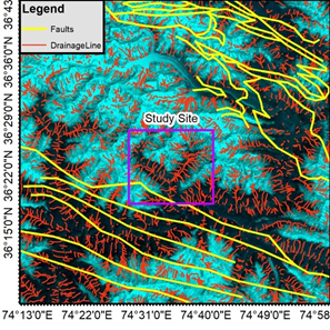
Figure 4. Integrated map of fault line map and drainage density.
The automated drainage pattern was drawn to examine the spatial distribution of drainage density as shown in the figure 4. Drainage density plays a vital role for understanding the regional tectonic setting in a better way.
Discussion
Figure 3 is showing a big mass of snow and running Shishper glacier which created a danger to infrastructure of Hassanabad situated just below the hill. It travelled about 2.2km during 12 months. There may be multiple reasons behind these movement for instance geological settings. Figure 4 is showing that there is an amalgam of fault lines which is responsible for instability in terms of mass movement. The drainage density map shows that the density of streams has increased many folds where the fault lines are situated. The complex drainage points the areas where there are heavy disturbance beneath the surface of earth. Main Karakorum fault is very famous which lies underneath the study site. This fault is most probably responsible for the movement of Shishper glacier. We computed the slope factor and found that the elevation dropwas about 550m within a distance of 7km, which show that there is high slop which may be favorable for Shishper to move forward. The main reason behind stoppage of this landmass in the accumulation of snow at month in which glaciers are projected to move fast, following the previous patterns.
Way forward.
Elevation drop on the way to Shishper glacier was computed to estimate slop factor as shown in the figure 5. This slop factor is important to examine sustainable assessment in future.
Figure 5. Elevation drop on the way of Shishper
It is probable to say that the snow mass is accumulating and a pressure is increasing. Due to slop factor, once the glacier start moving, it will destroy every kind of infrastructure on its way. Therefore, it is recommended that human settlements must be displaced to a suitable place to save human lives. The activation of this glacier may be in very near future due to its position on geologically active fault zone.
Conclusions
Glacial lakes are globally developing in high mountains due to changing climate and recession of glaciers. Remote sensing techniques and satellite imagery methods were used to analyze glacial lakes in Hunzariver basin for the assessment of susceptibility of GLOF events. Temporal satellite imagery determined that Shishper glacier has travelled 800m in first six months and about 1400m in the next six months in the year 2018. Digital Elevation model was describing the factors of glacial lakes which trigger GLOF events for instance climatic changes and increasing temperature.
References
- Ali,G.ScienceoftheTotalEnvironmentClimateChangeandAssociatedSpatialHeterogeneityofPakistan:EmpiricalEvidence Using Multidisciplinary Approach. Sci. Total , 634, 95–108, 2018. [CrossRef][PubMed]
- Kougkoulos, I.; Cook, S.J.; Jomelli, ; Clarke, L.; Symeonakis, E.; Dortch, J.M.; Edwards, L.A.; Merad, M. Science of the Total Environment Use of Multi-Criteria Decision Analysis to Identify Potentially Dangerous Glacial Lakes. Sci. Total Environ. Vol 621, pp: 1453–1466, 2018. [CrossRef]
- Ali,S.;Eum,H.I.;Cho,J.;Dan,L.;Khan,;Dairaku,K.;Shrestha,M.L.;Hwang,S.;Nasim,W.;Khan,I.A.AssessmentofClimate Extremes in Future Projections Downscaled by Multiple Statistical Downscaling Methods over Pakistan. Atmos. Res. Vol 222, pp: 114–133,2019.[CrossRef]
- Khattak, M.S.; Babel, M.S.; Sharif, M. Hydro-Meteorological Trends in the Upper Indus River Basin in Pakistan. Clim. Res.Vol 46, pp: 103–119, 2011. [CrossRef]
- Wang, ; Liu, Q.; Liu, S.; Wei, J.; Jiang, Z. Heterogeneity of Glacial Lake Expansion and Its Contrasting Signals with Climate Change in TarimBasin, Central Asia. Environ. Earth Sci. Vol 75, pp: 1–11, 2016.[CrossRef]
- Zhang, G.; Yao, T.; Xie, H.; Wang, ; Yang, W. An Inventory of Glacial Lakes in the Third Pole Region and Their Changes in Response to Global Warming. Glob. Planet. Chang. Vol 131, pp: 148–157, 2015. [CrossRef]
- Cook,S.J.;Kougkoulos,I.;Edwards,L.A.;Dortch,J.;Hoffmann,D.GlacierChangeandGlacialLakeOutburstFloodRiskinthe Bolivian Andes. Cryosphere pp: 2399–2413, 2016.[CrossRef]
- Nie, ; Sheng, Y.; Liu, Q.; Liu, L.; Liu, S.; Zhang, Y.; Song, C. A Regional-Scale Assessment of Himalayan Glacial Lake Changes Using Satellite Observations from 1990 to 2015 Remote Sensing of Environment A Regional-Scale Assessment of Himalayan Glacial Lake Changes Using Satellite Observations from 1990 to 2015. Remote Sens. Environ. Vol 189, pp: 1–13, 2017.[CrossRef]
- Farooqi, A.B.; Khan, A.H.; Mir, Climate Change PerspectiveinPakistan. Pak. J. Meteorol. Vol2, pp: 11–21, 2005.
- Hall, D.K.; Bayr, J.; Schöner, W.; Bindschadler, R.A.; Chien, J.Y.L. Consideration of the Errors Inherent in Mapping Historical Glacier Positions in Austria from the Ground and Space (1893–2001). Remote Sens. Environ. Vol 86, pp:566–577, 2003. [CrossRef]
- Jain, K.; Lohani, A.K.; Singh, R.D.; Chaudhary, A.; Thakural, L.N. Glacial Lakes and Glacial Lake Outburst Flood in a Himalayan Basin Using Remote Sensing and GIS. Nat. Hazards Vol 62, pp: 887–899, 2012. [CrossRef]
- Hewitt K Tributary glacier surges: an exceptional concentration at Panmah glacier, Karakoram Himalaya. JGlaciol, Vol 53, issue 181, pp:181–188, 2007.
- Iturrizaga L, Historical glacier dammed lakes and outburst floods in the Karambar valley(Hindukush-Karakoram). Geo Journal, VOL 63, issue 1–4, pp: 1–47, 2005.
- Fang, ; Cheng, W.; Zhang, Y.; Wang, N.; Zhao, S.; Zhou, C.; Chen, X.; Bao, A. Changes in Inland Lakes on the Tibetan Plateau over the Past 40 Years. J. Geogr. Sci. Vol 26, pp: 415–438, 2016.[CrossRef]
- Frey,;Huggel,C.;Paul,F.;Haeberli,W.Automated Detection of Glacier Lakes Based on Remote Sensing in View of Assessing Associated Hazard Potentials. Grazer Schriften Geogr. Raumforsch. Vol 45, pp: 261–272, 2010.
- Huggel,C.;Kääb,A.;Salzmann,N.;Group,G.GIS-Based Modeling of Glacial Hazards and Their Interactions Using Landsat-TM and IKONOS Nor. Geogr. Tidsskr.Nor. J. Geogr. Vol 58, pp: 61–73, 2004. [CrossRef]
- Prakash,C.Outburst Susceptibility Assessment of Moraine-Dammed Lakesin Western Himalaya Usingan Analytic Hierarchy Process. Earth Surf. Process. Landforms Vol 2321, pp: 2306–2321, 2017.[CrossRef]
- Aggarwal, S.; Rai, S.C.; Thakur, K.; Emmer, A. Geomorphology Inventory and Recently Increasing GLOF Susceptibility of Glacial Lakes in Sikkim, Eastern Himalaya. Geomorphology Vol 295, pp: 39–54, 2017.[CrossRef]
- Zhu, ; Xie, M.; Wu, Y. Quantitative Analysis of Lake Area Variations and the Influence Factors from 1971 to 2004 in the Nam Co Basin of the Tibetan Plateau. Chin. Sci. Bull. Vol 55, pp: 1294–1303,2010. [CrossRef]


