
Computation of Temporal Decline to a Vanished Island (A Case Study Zalzala Koh)
Muhammad Saifullah1, Ali Asghar2, Muhammad Ayaz Ahmad3, Memona Zafar4, Shazma Saman4, Muhammad Awais Arshad5, Azeem Akhtar1.
1 University of the Punjab, Lahore 2 Institute of management and sciences (Pak AIMS)
3 The Superior College Lahore.
4 Kohat University of Science & Technology, Kohat
5 Government Post Graduate College for Boys Gujranwala.
* Correspondence: Muhammad Saifullah E-mail : saifafridi1994@gmail.com
Citation | Saifullah.M, Asghar. A, Ahmad.A.M, Zafar.M, Saman.S, Arshad A.M, Akhtar.A. “Computation of Temporal Decline to a Vanished Island A Case Study Zalzal Koh”. International Journal of Innovations in Science & Technology, Vol 01 Issue 04: pp 142-150, 2019.
DOI | https://doi.org/10.33411/IJIST/2019010409
Received | June 25, 2019; Revised |July 27, 2019 Accepted | July 29, 2019; Published | Aug 03, 2019.
________________________________________________________________________
Abstract.
A massive tremor stuck Baluchistan Pakistan on September 24, 2013 with a magnitude of 7.7 recorded on Richter scale. The epicenter was Awaran Baluchistan which directly affected about 300,000 people leaving about 386 causalities. The impact of this earthquake was so much large that it created a new landmass which was named as Zalzala Koh later. It was the result of strike slip faulting at a depth of 15km. The new born island was full of rich minerals, gases and dead sea animals. This island was 60 feet high, 100 feet wide and 250 feet long. The classification results of Landsat 8 show that the island completely disappeared in 2019 after 6 six years of its birth. First the volume of this island decreases due to reduced pressure of internal gases and secondly, the high-pressure water waves vanished it completely. Satellite imagery proved efficient for Spatio-temporal monitoring of various landuse classes.
Keywords: Zalzala Koh; Richter Scale; Strike-Slip Fault; Minerals; Gases.
Introduction.
Seismic tremor or earthquakes are natural hazards which devastate the natural beauty and ecological balance of a region badly [1]. Major causalities are due to the clustered human settlements laying on folds or faults [2]. Severe damages occur near to the epicenters that result in floods, landslides, fires, broken infrastructure and collapsed buildings. The earthquake which hit Baluchistan in 2013 was one of the most hazardous earthquakes in the world. This earthquake had a magnitude of 7.7 with center at the southern end of Chaman fault. Chaman fault is an active fault which is 860 km long, running along Pak-China border, and ends in Arabian sea [3]. Historically, a deadliest earthquake occurred along this fault in 1935 which destroyed Quetta completely resulting in 30,000 causalities. Such type of earthquakes causes to create the mountains on earth’s surface and islands by slipping and collision of tectonic plates, e.g., the Nepal earthquake in 2015 [4].
Baluchistan earthquake occurred in 2013 and created a new island near Gwadar port. The magnitude of this earthquake was 7.7 which lasted for 8 seconds with the peak degree of damage. About 300,000 people were directly affected and the Awaran district was the most effected region because it was near to the epicenter. The mud, wood, and stone houses were completely demolished. Epicenter of this earthquake was 69km away in North of Awaran and 276 km away from Karachi where 6.11 million people were living [5]. The shocks of this earthquake were also observed in nearby countries e.g., Afghanistan, India and Iran. The location of earthquake was above Makran subduction zone. The event occurred due to the subduction of Arabian plate in North direction underneath the Eurasian plate. In continuity of 2013 Baluchistan earthquake, another earthquake hit Baluchistan in 2014. This earthquake resulted as 386 causalities and 816 people were injured. Above 32638 houses were completely destroyed and 14118 were partially damaged.
About four decades ago, the subduction zone was discovered along Makran coast [8] that was observed with high seismic activity [9] followed by various researches [10, 11, 12,13]. Many researches have been conducted to investigate seismic activity in Makran subduction zone [11-13].
Heidarzadeh along with his team [14,15] executed deterministic analysis to study five events of 8.1 magnitude and six events of 8.3 magnitude and found that the Makran subduction zone had a very deep history with complex tectonic arrangements [16,17,18]. They found that the Arabian plate was subducted beneath the Eurasian plate. This region is seismically active enough that 14 out of 23 strong earthquakes occurred along Makran coast [19,20,21] as shown in Figure 1. The earthquake which happened in 1945 was off the Makran coast that created an island which vanished later. Such earthquakes are powerful enough that a new coast line can be generated as a result e.g., an earthquake of magnitude 8.8 hit Chile in 2010 and changed the shape of coastline completely [22] and even shorten the length of day.
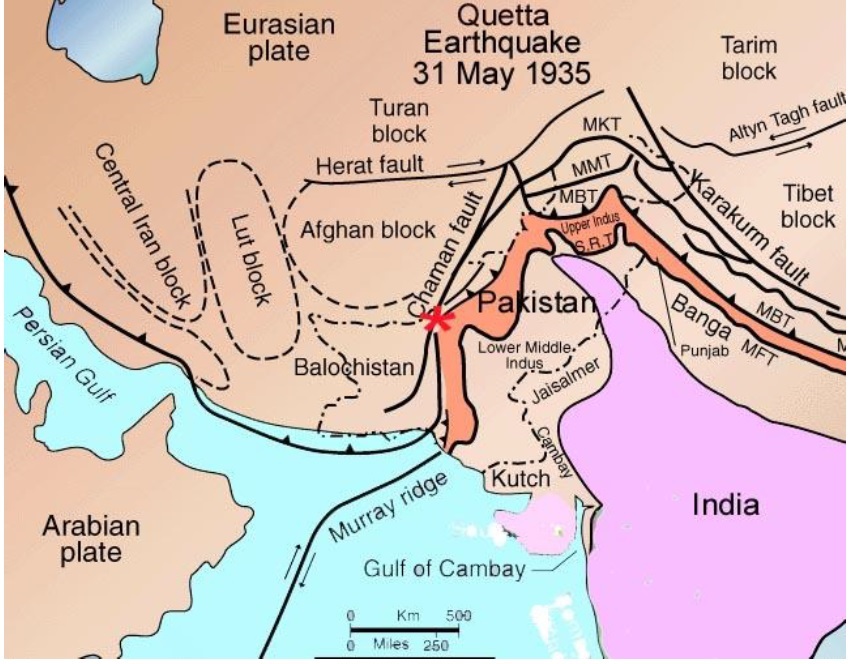
1. Seismic activity along Chaman fault. According to http://www.drgeorgepc.com/Earthquake1935PakistanQuetta.html
Similarly, Baluchistan earthquake was powerful enough that a new island was created as a result in Paddi Zirr near Gwadar Pakistan [23,24], which has named as Zalzala-Koh “a grey color mound”. The surface of this new born island was full of dead sea creatures and solid to walk. This island was composed of mud, sand and rock fragments. This island was 60 feet high, 100 feet wide and 250 feet long. Scientists were looking for existence of fossil fuel, methane and other rich minerals underneath it’s surface.
The main focus of this research was to investigate the spatio-temporal changes in the shape of Zalzala-Koh and the main reasons behind it’s getting vanished.
Material and Methods.
Study site.
The study site was generated as a result of severe earthquake which hit Baluchistan in 2013 with magnitude 7.7 at Richter Scale. It was a newly born island which was full of rich minerals, dead fish residue and other elements. Its size was very small but 99% volume of this island was under water. The study site was located at a spatial location 25.18oN and 62.26oE. The dimensions of this earthquake are shown in Figure 2. Figure 2 was captured by Earth Observing 1 satellite by National Aeronautics and Space Administration.
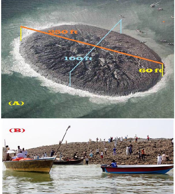
Figure 2. A) Newly born Island captured by NASA and B) People visiting this island.
We downloaded the satellite image of Landsat 8 from earth explorer website of various dates as mentioned in Table 1,
Table 1. Image acquisition dates along with spatial resolution.
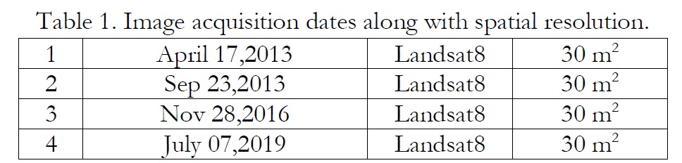
A Landsat satellite image is comprised of a spatial resolution of 30 m2 and a swath width of 185 km2 which consist of layers known as bands. In the first step, these layers were combined which known as layer staking. The staked image was further corrected geometrically and classified using spectral signature of soil and water. Both features were very easily discriminated on the basis of these spectral signatures.
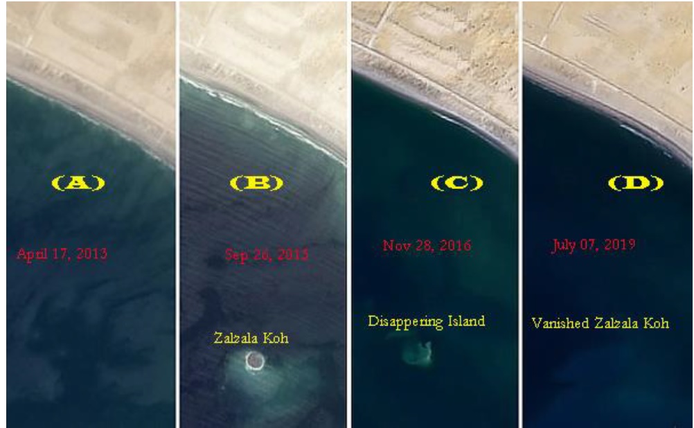
Figure 3. Spatio-temporal changes from birth to vanishing of Zalzalah Koh.
The results of supervised classification are shown in Figure 3. A part of figure 3 is showing that there exists no island near to coastline because this image was captured as pre-earthquake. The B part of this figure is showing that a new island has emerged which has named a Zalzala-Koh. Figure 3(C) is showing that the island has slightly disappeared and it’s volume has declined to much extent. Figure 3(D) is showing that the newly born island has completely vanished.
There may be many reasons behind the vanishing of this island. One of these reasons is the decline due to internal pressure of gases which were getting cool timely. At the time of happening of an earthquake, there exists a very large pressure of gases which reduced with time that caused to contract and square back the swelled land mass. Another reason of vanishing the Zalzala island was due to the slipping of raw material underneath it’s base.
Discussions:
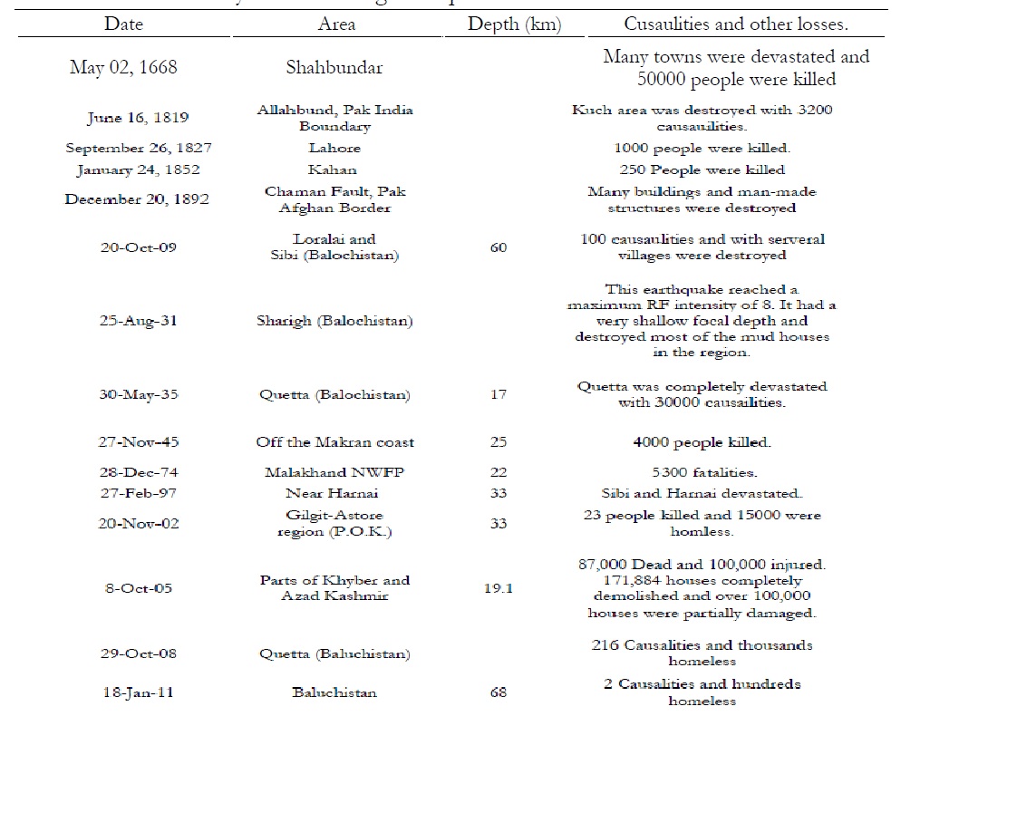
According to Pakistan metrological department, Quetta and its outskirts along Makran coast fall in Zone 4 of seismic division in Pakistan. This zone is considered a highly vulnerable to earthquakes due to the Chaman fault and other raptures to Indian plate. Historically, most of deadly devastating earthquakes occurred in Baluchistan as shown in Table 2.
Table 2. History of devastating earthquakes in Baluchistan.
Indian plate is small in size as compared to Eurasian plate. Indian plate is moving towards north as 48mm/year. The western and northern edges of Indian plate have created the highest peaks of the world including Hindukush, Himalaya and the Karakaram range. This zone is seismically active enough that we get highest surface deformations in this region. A Chaman fault system was generated in 1505 due to the rapture in Indian plate that caused the devastation to Kabul in Afghanistan. The earthquake of September 24,2013 caused to form a new island which proves that Indo-Pak plate is moving in northward direction along the oblique-strike-slip fault. The northward and downward motion of Arabian plate underneath the Eurasian plate caused to push the thick layer of rocks and mines which caused to appear an island. Such islands have short lives. First their volume is decreases due to reduced pressure of internal gases and secondly, the high-pressure water waves may washout such structures.
Conclusion:
The Baluchistan earthquake 2013 was a drastic earthquake that resulted in 386 causalities. Remote sensing and GIS techniques proved efficient for computation of spatial variations from born to vanishing of Zalzala island. It has become a need of time to predict the earthquake well in time to humans.
Author’s Contribution. All the authors contributed equally.
Conflict of interest. We declare no conflict of interest for publishing this manuscript in IJIST.
Project details. NIL
References:
1. K. Crowley, J. R. Elliott?(2012), Earthquake disasters and resilience in the global North: lessons from New Zealand and Japan,?The Geographical Journal,?178, 208-215,?doi:10.1111/j.1475-4959.2011.00453.x.
2. Quadri, V.N. & S.M. Quadri. Cretaceous of Pakistan, India should hold more promise. Oil and Gas Journal 6: 1-4 (1998).
3. The 2011 Mw 7.1 Van (Eastern Turkey) Earthquake,?Journal Geophysical Research,?118, 1619-1637,doi:10.1002/jgrb.50117.
4. S. Ul-Hadi, S.D. Khan, L. A. Owen, A.S. Khan, 2013. Geomorphic response to an active transgressive regime: a case study along the Chaman strike-slip fault, Western Pakistan. Earth Surface Processes and Landforms; 38(3):250-264.
5. J. R. Elliott, R. Jolivet, P. Gonzalez, J. P. Avouac, J. Hollingsworth, M. Searle, V. Stevens (2016), Himalayan Megathrust Geometry and Relation to Topography Revealed by the Gorkha Earthquake,? Nature Geoscience,9, 174-180, doi:10.1038/NGEO2623.
6. Kazmi, A.H. Active fault systems in Pakistan. In: Geodynamics of Pakistan. Farah, A. & K.A. DeJong (Ed.). Geological Survey of Pakistan, Quetta, p. 285-294 (1979).
7. Nakata, T. Active faults of the Himalaya of India and Nepal. In: Tectonics of the Western Himalayas. Malinconico, L.L. & R.J. Lilie (Ed.). Geological Society American Special Paper 232, p. 243-264 (1989).
8. PMD, Pakistan Meteorological Department, Government of Pakistan, Ismalabad.
9. UNOCHA, Baluchistan Earthquake 2013: Assessment Findings & Humanitarian Strategies, UN Office for Coordination Humanitarian Affairs, October 2013. Accessed on 14 Dec. 2016.
10. Byrne, D.E., L.R. Sykes & D.M. Davis. Great thrust earthquakes and aseismic slip along the pate boundary of the Makran subduction zone. Journal of Geophysical Research 97: 449-478 (1992)
11. Stoneley, R (1974). Evolution of the continental margins bounding a former southern Tethys, in: The Geology of the Continental Margins, edited by: Burk, C. A. and Drake, C. L., 1st Edn., Springer-Verlag, Berlin, Heidelberg.
12. Quittmeyer, R. C. and Jacob, K. H (1979). Historical and modern seismicity of Pakistan, Afghanistan, northwestern India, and southeastern Iran, B. Seismol. Soc. Am., 69, 773?823.
13. W. D.Page, J. N. Alt, L. S. Cluff, G. Plafker, (1979). Evidence for the recurrence of large-magnitude earthquakes along the Makran coast of Iran and Pakistan, Tectonophysics, 52, 533?547.
14. D. E. Byrne, L. R. Sykes, D. M. Davis, 1992. Great thrust earthquakes and aseismic slip along the plate boundary of the Makran subduction zone. Journal of Geophysical Research, 97(B1), 449?478, 1992
15. A. K. Jadoon, 1992, "Ocean/continental transitional crust underneath the Sulaiman Thrust Lobe and an evoluationary tectonic model for the Indian/Afghan Collision Zone", Pakistan Journal of Hydrocarbon Research, v.4, no.2, p.33-45.
16. El Hussain, R. Omira, A. Deif, M. A. Baptista: Probabilistic tsunami hazard assessment along Oman coast from submarine earthquakes in the Makran subduction zone, Arabian Journal of Geosciences 9(15), 2016
17. M. Heidarzadeh, M. D. Pirooz, N. H. Zaker, C. E. Synolakis (2008a). Evaluating Tsunami Hazard in the Northwestern Indian Ocean, Pure Appl. Geophys., 165, 2045?2058
18. Heidarzadeh, M., Pirooz, M. D., Zaker, N. H., and Yalciner, A. C (2008b). Preliminary estimation of the tsunami hazards associated with the Makran subduction zone at the northwestern Indian Ocean, Nat. Hazards, 48, 229?243
19. M. Heidarzadeh, A. Kijko, A probabilistic tsunami hazard assessment for the Makran subduction zone at the northwestern Indian Ocean, Natural Hazards 56(3):577-593, 2011
20. Heidarzadeh, Mohammad & Kijko, Andrzej. (2011). A probabilistic tsunami hazard assessment for the Makran subduction zone at the northwestern Indian Ocean. Natural Hazards. 56. 577-593. 10.1007/s11069-010-9574-x.
21. Kijko, A. and Smit, A (2012). Extension of the Aki-Utsu b-Value Estimator for Incomplete Catalogs, B. Seismol. Soc. Am., 102, 1283? 1287.
22. Byrne, D.E., L.R. Sykes & D.M. Davis. Great thrust earthquakes and aseismic slip along the pate boundary of the Makran subduction zone. Journal of Geophysical Research 97: 449-478 (1992)
23. Stoneley, R (1974). Evolution of the continental margins bounding a former southern Tethys, in: The Geology of the Continental Margins, edited by: Burk, C. A. and Drake, C. L., 1st Edn., Springer-Verlag, Berlin, Heidelberg.
24. Quittmeyer, R. C. and Jacob, K. H (1979). Historical and modern seismicity of Pakistan, Afghanistan, northwestern India, and southeastern Iran, B. Seismol. Soc. Am., 69, 773?823.
25. W. D.Page, J. N. Alt, L. S. Cluff, G. Plafker, (1979). Evidence for the recurrence of large-magnitude earthquakes along the Makran coast of Iran and Pakistan, Tectonophysics, 52, 533?547.
26. D. E. Byrne, L. R. Sykes, D. M. Davis, 1992. Great thrust earthquakes and aseismic slip along the plate boundary of the Makran subduction zone. Journal of Geophysical Research, 97(B1), 449?478, 1992
27. A. K. Jadoon, 1992, "Ocean/continental transitional crust underneath the Sulaiman Thrust Lobe and an evoluationary tectonic model for the Indian/Afghan Collision Zone", Pakistan Journal of Hydrocarbon Research, v.4, no.2, p.33-45.
28. El Hussain, R. Omira, A. Deif, M. A. Baptista: Probabilistic tsunami hazard assessment along Oman coast from submarine earthquakes in the Makran subduction zone, Arabian Journal of Geosciences 9(15), 2016
29. M. Heidarzadeh, M. D. Pirooz, N. H. Zaker, C. E. Synolakis (2008a). Evaluating Tsunami Hazard in the Northwestern Indian Ocean, Pure Appl. Geophys., 165, 2045?2058
30. Heidarzadeh, M., Pirooz, M. D., Zaker, N. H., and Yalciner, A. C (2008b). Preliminary estimation of the tsunami hazards associated with the Makran subduction zone at the northwestern Indian Ocean, Nat. Hazards, 48, 229?243
31. M. Heidarzadeh, A. Kijko, A probabilistic tsunami hazard assessment for the Makran subduction zone at the northwestern Indian Ocean, Natural Hazards 56(3):577-593, 2011.
32. Heidarzadeh, Mohammad & Kijko, Andrzej. (2011). A probabilistic tsunami hazard assessment for the Makran subduction zone at the northwestern Indian Ocean. Natural Hazards. 56. 577-593. 10.1007/s11069-010-9574-x.
33. Kijko, A. and Smit, A (2012). Extension of the Aki-Utsu b-Value Estimator for Incomplete Catalogs, B. Seismol. Soc. Am., 102, 1283? 1287.
34. Jadoon,?I. A. K., and Khurshid, A (1996).? Gravity and tectonic model across the?Sulaiman fold belt and the Chaman fault zone in western?Pakistan?and eastern Afghanistan.?Tectonophysics, v. 254, p. 89-109.
35. Jadoon, I.A.K., (2010). Tectonic map of the central and western Sulaiman fold belt, Pakistan, COMSATS Institute of Information Technology, Abbottabad, Pakistan.
36. Kazmi, A.H. and Jan, M.Q.:?Geology and Tectonics of Pakistan:?Karachi (Graphic Publishers) (1997). Mineralogical Magazine,?February 2000, v.?64, p.?152-153,?published online February 1, 2000.


