
Dam Site Identification Using Remote Sensing and GIS (A case study Diamer Basha Dam Site)
Muhammad Zubair Atiq1, Muhammad Arslan2, Zahid Baig3, Aleem Ahmad4, Muhammad Usman Tanveer1, Azeem Akhtar1, Azam Sohail1, Kashif Naeem5 and Syed Amer Mahmood1.
1 Department of Space Science, University of the Punjab Lahore, Punjab Pakistan.
2 University of the Central Punjab Lahore.
3 Punjab University, College of Information and Technology.
4 Punjab University, Centre for Geographic Information System.
5 Institute of Management Science PAKAIMS Lahore
*Correspondence | Zubair Ateeq E-mail: mzubairatiq@gmail.com
Citation | Ateeq Z, Arslan M, Baig Z, Ahmad A, Tanveer M.U, Akhtar A, Sohail. A, Naeem K and Mahmood S.A, “Dam Site Identification Using Remote Sensing and GIS (A case study Diamer Basha Dam Site)”. International Journal of Innovations in Science and Technology, Vol 01 Issue 04: pp 168-178.
DOI | https://doi.org/10.33411/IJIST/2019010412
Received | August 09, 2019; Revised |Sep 10, 2019 Accepted | Sep 15, 2019; Published | Sep 18, 2019.
_____________________________________________________________________
Abstract.
Selection of suitable sites for construction of dam is the most important phase because a number of factors are required to consider that include topography, geology, tectonic settlements and the slope. We selected Diamer Basha dam site to analyze it feasibility considering real-time field data. Geologically the study site is a part of Chilas Mafic Igneous Complex which is not ophiolite. Matic complex is a block which is 40km in depth and 300km in length. These rocks are comparatively hard in nature and are considered good for construction of dam. Tectonically, we observed that the area under investigation was highly active tectonically. Surface deformation rates of the study site are highest throughout the world because this area is comprised of multiple fault lines that include Main Mantle Thurst (MMT), Main Karakoram Thrurst (MKT), Main Boundary Thurst (MBT) and many others. This area has become a hot cake for the geologist worldwide due to it’s very high surface deformation rates.Tectonically active regions are considered worst for construction sites, e.g., for dam sites. The dam site is actcually laying on the MKT which is not favorable for construction of Diamir Basha dam. A low-level earthquake may generate small cracks in concrete structure and any leakage of water may produce big holes with passage of time which are not remidable. A big level earthquake may vanish the dam site completely. Therefore, the current site is not favorable for construction of dam.
Keywords. MMT, MKT, MBT, Suitable sites selection and Geology.
1. Introduction.
Vast areas and agricultural lands are affected by floods that last for many days. The complete infrastructure and ecology are badly disturbed by flood water which may lead to worsen the catastrophic and morphological characteristics of an area. There are many preventives measures which can be taken to avoid after flood situations such as constructions of canals, big drainage systems and dams. Dams are considered the best solution to tackle such accidental events in a better way [1]. Dams and water structures are built to control multiple events such as soil and sedimental erosion, irrigation systems, droughts and mainly for generation of electricity. About 60% of flood water is regulated by reservoirs and dams. There are multiple classes of dams based on engineering point of view such as structural design, hydraulic design and the hydro-electric designs [2].
Hydropower is green energy which is ecofriendly source for many countries [3]. The initial cost of hydro power project is huge and the dams are considered as one of the major sources of hydro power generation. [4]
There are a number of points which must be taken in consideration before dam construction that include valley shape, topography, geological structures, spillway size, roadways, frequency of earthquakes, climate of the dam site, life and height of dam [5]. In all these scenarios, topography, geological structure and frequency of earthquakes are considered most important factors to incorporate before construction of a dam [6].
Topography is the key element that effects all forces which control the overall flow of water into a region [2]. If there is a relief in topography, it will lead to less erosion or incision and vice versa, because a gentle topography does not allow water to move with high pressure resulting in less erosion [7]. Therefore, it is important to compute slop/aspect map to check the nature of topography where a dam is to be constructed [8]. It is recommended that slop must be less than 5% for construction of a dam [9].
Tectonic arrangements underneath a dam site play a vital role in selecting suitable regions to construct a dam [10]. The weightage of a tectonic arrangement is almost very high because the internal forces beneath the earth’s surface are strong enough to disturb the complete face of a region within seconds. The regions with high surface deformation rates are discouraged for construction of dams [11].
The size of a catchment area is also considered while constructing a dam. Its size should be within range to feed the dam properly [12]. A very big catchment lead to expensive spillway which is not economical. Hydrological mode of a study site provides drainage points, drainage lines, catchment areas and the overall flow in cusec [13].
GIS has a set of powerful tools known as “Arc Hydro Tools” which provides a watershed model of a study site [14]. Digital Elevation Model (DEM) is commonly used as input to compute the drainage pattern within a study site [15].
Geological settlements of a particular region are important to consider for construction of a dam [16]. Existing geology provides information about available material in a study site. Rocky foundations give high resistance to erosion and incision [17]. Metamorphic rocks bases are hard in nature therefore, these are considered good while constructing a dam [18,19].
The main objective of this research was to analyze the feasibility for construction of Diamer Basha dam while incorporating real-time factors including topography, geology, tectonic arrangement and hydrology of the study site.
Study area.
Diamer-Basha-Dam is a gravity dam which is concrete filled and under construction on Indus river in KPK. This site is located near a place known as Basha which is owned by Water and Power Development Authority (WAPDA). The initial cost of dam was estimated as 14 billion USD in 2013 with height 272m. Projected storage capacity is expected as 1000Mm3 which will produce 4800 MW electricity upon completion. The diversion system of Diamer-Basha-dam has one canal with two tunnels and spillways having nine gates of size 16.5*15.0m. This dam will affect 31 villages including 4100 households covering a population of 35000 in numbers. An area of 6.1km2 will be submerged as agricultural land. The area under investigation is mapped in Figure 1, as below.
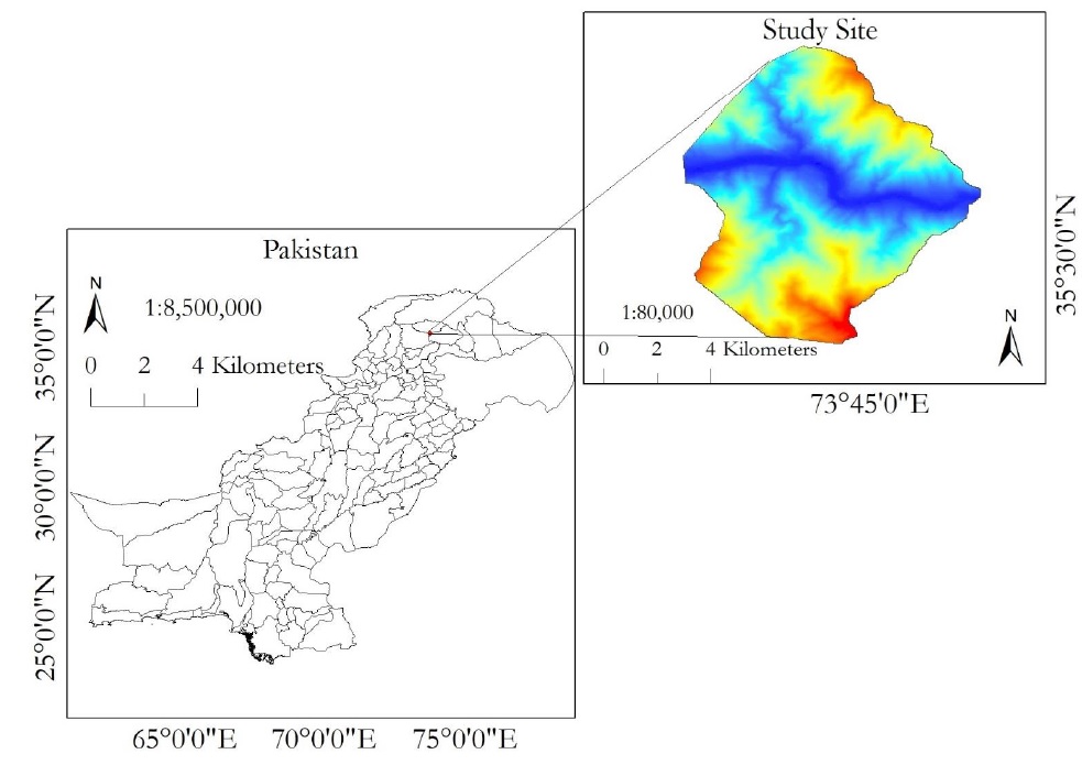
Figure 1. Location of Diamer Basha Dam Site.
Material and Methods
We acquired a DEM of the study site from United State Geological Survey (USGS) website (https://earthexplorer.usgs.gov/) and applied Arc Hydro tools in Arc GIS to draw a watershed model using methodology as shown in Figure 2.
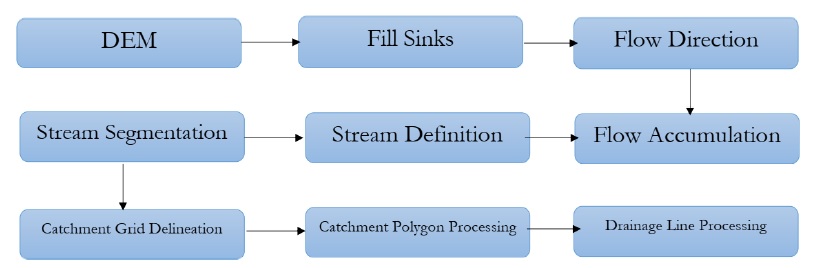
Figure 2. Extraction of drainage network using DEM.
In the first step, sinks were filled and flow direction was computed against each cell. Next, flow was accumulated from each cell to define the stream network. Finally, catchment areas were drawn and the drainage lines were extracted in vector form.
We used DEM to compute slope map of the study site using 3D analyst utility in Arc GIS. The main purpose of this calculation was to evaluate the nature of topography under investigation.
We acquired a map of the study site to investigate the nature of rocks underneath the investigation site. This map was georeferenced and digitized for further processing. We acquire another map of tectonic settlements within or in outskirts of study area. This map was also georeferenced and digitized to draw fault lines existing near to the DAM site.
Result and discussions.
Figure 3 is showing watershed model of the study site which is comprised of a main stream that is Indus river and the joining tributaries against each catchment. The shape of any tributary represents the topographical disturbances in any catchment. If the shape a stream is irregular and non-linear, it represents a very irregular topography. Catchment areas may be termed a sub-basins with unique flow through a water channel flowing toward the main stream. If a stream within a network changes its path suddenly, it represents the existence of a hard rock underneath the earth’s surface which forced water to move in different direction. A bend is observed at location A in the study site where Diamer Basha dam is under construction actually which show the presence of hard rock there that was initial requirement for construction of dam.
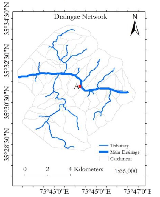
Figure 3. Watershed model of the study site.
Geologically the study site is a part of Chilas Mafic Igneous Complex which is not ophiolite as shown in Figure 4. Matic complex is a block which is 40km in depth and 300km long that is comprised of plagioclase, orthopyroxenc, clino pyroxenc ilmenite, magnetite, flood spar, quartz, hornblende, scapolite and biotite. The rocks of this complex are petrographic which resemble with plutonic blocks. These rocks are comparatively hard in nature and are considered good for construction of dam. Therefore, this area is suitable dam sites.
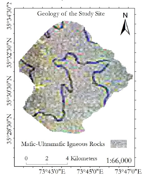
Figure 4. Geology of the study site.
Dams require gentle slops because gentle slop offer less erosion/incision and finally less amount of sedimentation. The slop map of the study site represent a percentage slop as shown in Figure 5. Overall slope of study site is greater than 5% which is not favorable for construction of dam. The areas highlighted with red color in Figure 5 have high slopes in comparison to blue areas. The areas adjoing to Indus river were found having gentle slops while the far topography was observed steeper. In context of slop, the study site is not suitable for construction of a dam because a big flow of rainy water from Gilgit may exert enough pressure that can vanish the dam completely.
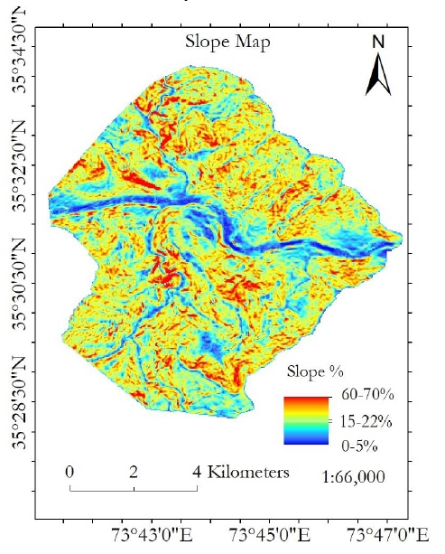
Figure 5. Slope map of the study site.
Tectonic activity underneath a construction site is indeed the most important factor which must not be ignored for the success of a project. We observed that the area under investigation was highly active tectonically. Surface deformation rates of the study site are highest throughout the world because this area is comprised of multiple fault lines that include Main Mantle Thurst (MMT), Main Karakoram Thrurst (MKT), Main Boundary Thurst (MBT) and many others. This area has become a hot cake for the geologist worldwide due to it’s very high surface deformation rates.
Tectonically active regions are considered worst for construction sites, e.g., for dam sites. Figure 6 is showing that dam site is actcually laying on the MKT which is not favorable for construction of Diamir Basha dam. A low-level earthquake may generate small cracks in concrete structure and any leakage of water may produce big holes with passage of time which are not remidable. A big level earthquake may vanish the dam site completely. Therefore, the current site is not favorable for construction of dam.

Figure 6. Tectonic arrangements in the study site.
Conclusions.
The study site is surrounded by a number of highly active fault lines. The surface deformation rates within this region, are recorded highest throughout the world. Such tectonically active regions are not favorable for construction sites in any scenario. Although other factors such as topography, slope and drainage pattern are in favor of construction of dam but the weightage of tectonic arrangement supersede all these factors and does not allow this site for construction of dam.
Acknowledgement.
We acknowledge earth explorer for provision of valuable data to accomplish this task. Author’s Contribution.All the authors contributed equally.
Conflict of interest. We declare no conflict of interest for publishing this manuscript in IJIST.
Project details.NIL
Reference
1. Munyao, J.N. (2010) Use of Satellite Products to Assess Water Harvesting Potential in Remote Areas of Africa: A Case Study of Unguja Island. Enschede, The Netherlands.
2. Dorfeshan, F., Heidarnejad, M. and Bo, A. (2014) Locating Suitable Sites for Construction of Underground Dams through Analytic Hierarchy Process. International Conference on Earth, Environment and Life Sciences (EELS-2014), Dubai (UAE),23-24 December 2014, 86-90.
3. Abushandi, E. and Alatawi, S. (2015) Dam Site Selection Using Remote Sensing Techniques and Geographical Information System to Control Flood Events in Tabuk City. Hydrology: Current Research.
4. Beavers Advisory Committee for England. (2017) Site Selection Criteria. https://beaversinengland.com/reintroductions/release-site-selection criteria/
5. Ghazal, N.K. and Salman, S.R. (2015) Determining the Optimum Site of Small Dams Using Remote Sensing Techniques and GIS. International Journal of Scientific Engineering and Research (IJSER), 3, 69-73.
6. Thanoon, H.A. and Ahmed, K.A. (2013) Hydrological Information Extraction for Dams Site Selection Using Remote Sensing Techniques and Geographical Information System. Al-Rafidain Engineering, 21, 102-114.
7. Xu, C.-Y. (2002) Hydrologic Models. Uppsala University Department of Earth Sciences Hydrology, Uppsala.
8. Lalhmingliana and Saha, G. (2016) Identification of Suitable Dam Site: A Survey. International Journal of Computer Engineering & Technology (IJCET), 7, 56-64.
9. Manugula, S.S., Veeranna, B. and Patel, S. (2015) Geo-Spatial Data Foundation for Dam Sites. International Journal of Civil Engineering and Technology (IJCIET), 6,61-68.
10. Dai, X. (2016) Dam Site Selection Using an Integrated Method of AHP and GIS for Decision Making Support in Bortala, Northwest China. Lund University, Lund.
11. Emiroglu, M.E. (2008) Influences on Selection of the Type of Dam. International Journal of Science & Technology, 3, 173-189.
12. Lashkaripour, G. and Ghafoori, M. (2002) The Engineering Geology of the TabarakAbad Dam. Engineering Geology, 66, 233-239. https://doi.org/10.1016/S0013-7952(02)00044-3
13. Mati, B. (2017) Water Harvesting and Storage in Valleys Using Small Earth Dams.http://www.jkuat.ac.ke/departments/warrec/wpcontent/uploads/2016/05/Water-harvesting-and-storage-in-Valleys using-Earth-Dams.pdf
14. Stephens, T. (2010) Manual on Small Earth Dams. A Guide to Siting, Design and Construction. Food and Agriculture Organization of the United Nations, Rome.F. M. Njiru, D. N. Siriba DOI: 10.4236/gep.2018.67009 132 Journal of Geoscience and Environment Protection
15. Ajin, R.S., Krishnamurthy, R.R.K., Jayaprakash, M. and Vinod, P.G. (2013) Flood Hazard Assessment of Vamanapuram River Basin, Kerala, India: An Approach Using Remote Sensing & GIS Techniques. Advances in Applied Science Research, 4, 263-274.
16. Ghoraba, S.M. (2015) Hydrological Modeling of the Simly Dam Watershed (Pakistan) Using GIS and SWAT Model. Alexandria Engineering Journal, 54, 583-594.
17. Engineering Articles (2015) Selection of Dam Site. http://www.engineeringarticles.org/selection-of-dam-site/
18. Tim, U.S. and Mallavaram, S. (2003) Application of GIS Technology in Watershed-Based Management and Decision Making. Watershed Update, 1, 1-6.
19. Hosseinzadeh, S.R. (2011) Drainage Network Analysis, Comparis of Digital Elevation Model (DEM) from ASTER with High Resolution Satellite Image and Areal Photographs. International Journal of Environmental Science and Development, 2, 194-198.


