
Monitoring of Mangrove Cover of Western Indus Delta Karachi Pakistan
Nasir Abbas1, Nimra1, Warda Habib2
1Department of Geography Government College University Lahore, Pakistan
2University of Minnesota USA.
* Correspondence: Nasir Abbas (nasirgcu@gmail.com)
Citation | Abbas. N, Nimra, Habib. W “Monitoring of Mangrove Cover of Western Indus Delta Karachi Pakistan”. International Journal of Innovations in Science & Technology, Vol 03 Issue 02: pp 59-66, 2021.
Received |March 27, 2021; Revised | April 15, 2021; Accepted | April 20, 2021; Published | April 25, 2021.
_______________________________________________________________________
Abstract
The coastline of Pakistan comprises of five significant sites comprising of mangroves including Indus Delta which contains extensive mangroves zones and termed as the largest arid mangrove found globally. This study evaluate the current extent of mangroves along the Western edge of Indus Delta and provide the most recent forest cover assessment of mangroves. Moreover, this study identifies the changes occurred in forest cover from the years 2000 to 2020. Landsat 5 Thematic Mapper (TM), 8 Operational Land Imager (OLI) and Landsat 7 ETM data were used for mangroves mapping through supervised classification method. The results displayed that total area of mangrove forest cover was nearly 279.094km², 395.77km², 306.58km² in the years 2000, 2010 and 2020 respectively. This study indicates an increase in area of mangrove cover from 29% to 41% from the year 2000 to 2010. Regeneration of mangrove mostly took place around the southern region of the Indus Delta. The mangrove specie has decreased from 41% to 31% from the year 2010 to 2020. The major causes of this reduction were urban water and industrial pollution, over-fishing in Indus delta, freshwater diversion for agriculture, and overharvesting of mangroves by the local communities, coastal erosion and sedimentation.
Keywords: mangrove; specie; arid; industrial pollution; Thematic Mapper.
Introduction
Mangroves forests are the valuable ecosystem for marine and coastal life, found in the intertidal zones of tropics and subtropical regions of world. These play a vital role as barriers between land and sea and act as natural shield against land erosion, tropical cyclones, and disasters and protect the shoreline [1]. Mangrove forests act as a shield for coastal areas to cope with flood, which are often affected by oceanic waves or rainstorms. Mangroves are the most diverse and productive ecosystems on planet earth. These forests have unique characteristics; which can survive under harsh saline environmental conditions [2]. The favorable environmental conditions for growth of mangroves forests are muddy soil, enough rainfall and temperature ranging from 26-28ºC. Mangroves forests are beneficial for both human as well as natural environment [3]. The vegetated are useful habitats for estuarine species, fish, bivalves, crustaceans and birds providing them with food and protection. Nearly two million kilogram of the fish is produced with the support of mangroves and sea grass bed annually. Mangroves are also economically beneficial for local communities providing them with timber, fuel and fodder. Mangroves act as sink of carbon which grows in coastal areas to limit the outbreak of mosquitoes [4].
Mangrove forests are under the serious threat these days. During the last two decades of twentieth century, about 35% of the World mangrove forests disappeared. According to Splading 2006, the area under mangroves was estimated as 181000 km2 globally during 1997 [5]. According to Giri 2014, this area reduced to 137760 km2 in 2011 and then to 83495 km2 stated by Hamilton and Casey in 2016. Anthropogenic activities including coastal urbanization, port development, conversion to agricultural land and over exploitation of timber and aquaculture played a vital role in this decline. Growth in aquaculture resulted with 38% of mangrove loss globally [6, 7, 8].
The coastal belt of Pakistan is extended up to 1050 km2 in Sindh (350 km2 and Baluchistan (700 km2) [9]. About 97% of mangrove forests of Pakistan are located in the province of Sindh along the Indus Delta which cover about 600,000 ha, stretched from Korangi Creek in the north to Sir Creek in the south. Indus delta consists of 17 major creeks along various minor creeks and widespread mudflats [10].
The survival of mangrove vegetation requires a continuous supply of water from sea to survive in the deltaic region. The raising vegetation is irrigated by tidal water which in 24 hours runs twofold over the islands [11]. Avicenna is the chief cultivated crop in the area, which is determined by the range of tidal water. The crops grow faster closer to creek but growth descends rapidly inside the island. It is believed that the Indus delta had about eight mangrove species in past, out of which four still thrive. About 95% of the mangrove species found along the Indus delta which are Avicennia marina, Ceriop-stagaland Aegiceras corniculatumare [12]. IUCN and WWF have been actively involved in Sindh and Balochistan for the active rehabilitation and conservation programs of mangrove. From 1985 IUCN Pakistan, in cooperation with the Sindh Forest Department, has jointly executed mangrove restoration programs along the coastline of Sindh [13, 14, 15]. These rehabilitation programs are executed along the coast by the involvement of local community. The main objective of this research was to monitor mangrove cover (in both degradation/upgradation) along the coastline.
Study Area
The study site included Western side of Indus Delta, Karachi. It is located on the bank of Arabian Sea; the Delta is circumvented by elongated and slim creeks, mud flats and by the Arabian Ocean mangroves of the Indus Delta, which is the biggest mangrove forest ecosystems found in parched climate [16]. Port Qasim is located on the fringe of river Indus at thirty-five kilometers east in Karachi. Port Qasim is located on the northwest fringe of the Indus Delta (Figure 1). It is the second busiest port of Pakistan, controlling thirty five percent of the country's shipment (seventeen million tons annually) [17,18]. About ninety percent of the external trade of the country is handled along with Port Qasim and Karachi Port. So, Indus delta is providing natural and economic benefits.
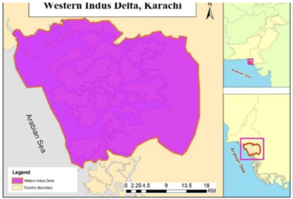
Figure 1. Study Area Map of Western Indus Delta, Karachi
Data and Method
Image Data
Digital satellite data is freely available and downloaded from USGS website for the years 2000, 2010 and 2019 and layer stacking of spectral bands was executed [19,20].
Table 1. Satellite data acquisition details
|
Image Acquisition Dates |
Satellite |
Resolution |
|
28-01-2000 |
Landsat 5 thematic Mapper TM |
30m |
|
20-01-2010 |
Landsat & ETM |
30m |
|
22-01-2020 |
Landsat 8 operational land Imager (OLI) |
30m |
Supervised Classification (Maximum Likelihood)
After extraction of desired area, supervised classification (maximum likelihood) was performed in ARC GIS 10.3 to meet the requirements of research goals [21,22].With the help of classification tool bar Polygons were drawn for each sample object. The area was classified into major classes as Mangroves, Water, Mudflats and Sand.
Signature files were created of these sample objects [23]and maximum likelihood classification technique was applied. In input raster field, image layer was added and in input signature file the created signature file was added[24].
Results and Discussions
Current study evaluates the existing status and spatial distribution of Mangroves along the western part of Indus delta, Karachi. Land maps of study site were designed using pixel-based classification technique in ARC GIS 10.3 software.
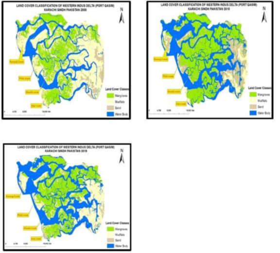
Figure 2. Land cover classification of western Indus delta of year (2000), (2010) and (2020)
Analysis of Land Cover Classes for the year (2000)
The land cover map of the year (2000) shows the clear distribution of four classes of land cover including mangroves, water body, mudflats and sand (Figure 2). The statistical data calculated by the pixel-based classification gives the accurate description of land cover. According to which, the mangroves occupy 279.0944km² which is about 29.10% of the total area. Water is about 215.22km² of the total area. Mudflats dominate with 405.183km² of the total area and sand covers about 59.36km².
Analysis of Land Cover Classes for the year (2010)
According to the pixel-based classification, mangroves covered 395.065km² area of study site which was about 41.27% of the total area. Water covered about 349.065km² of the total area which was 36.40% of total area, Mudflats covered 71.966km² which was about 7% of total area and sand covered about 142.079km² of the total area.
Analysis of Land Cover Classes for the year (2020)
The statistical data calculated by the pixel-based classification for the year 2020 provides the accurate description of land cover. According to these statistics, the area covered by mangroves diminished up till 306.58km² of the total area which was about 31.97%. Water dominated with 374.43km² of the total area which was 39.04%, Mudflat occupied 251.76km² areas which was about 26.25% of total area and sand covered about 26.096km².
This study used maximum likelihood classification technique for different land cover classes. The varying trends in land cover from 2000 to 2020 have been observed (Figure 2). This study indicates overall 12.17% increase in mangrove area from 2000 to 2010 while reduction phenomenon was observed about 10.3% from 2010 to 2020.
In 2000, mangrove area was 29.1% of the total area covered area, which was further increased up to 41.27% in year 2010 of the total area and then again decreased up to 30.97% of total area. The results further reveal that, the percentages land covers of mudflats and water also varies from 2000 to 2020. For this variation visual comparison of resultant classified images have been applied which shows clear differences between land cover classes for respective years.
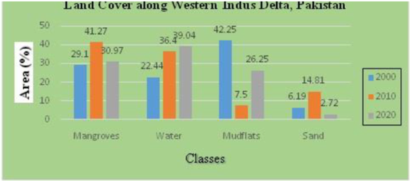
Figure 3. Bar graph of Land Cover Area Along Western Indus Delta
Comparison of Land Covers (2000-2010-2020)
The result of classified images showed that mudflats dominate the study area, approximately 42% of the total land is mudflats and 36% of the total area is water. The change detection illustrates the decrease in mudflats area and increase in water area from 2000 to 2020. The analysis of the year 2000 indicates that the total area of mangrove cover in the western side of Indus delta was about 279.0944km² ranging from Korangi creek to Khai Creek. In Landsat image of 2000, sand cover has also been classified with an area of about 59.36km². Other land cover statistics are given in Table 2. Landsat image of 2010 analysis show that the total cover of mangrove area was about 395.7759km² and sand was142.07km².
This approach represented an increasing trend in mangrove area from 2000 to 2010 and a decreasing trend from 2010 to 2020. The changes in the expansion of mangrove were observed in 2010. Figure 3 shows the bar graph of Land Cover area Along Western Indus Delta. Most of expansion can be seen in southern part whereas in Northwest part of mangroves has not changed. The increase in mangroves vegetation in the above-mentioned year was because of natural regrowth along southern part. Human efforts were among contributing factors for the rehabilitation of mangrove plantation. But these days mangroves are under threat and continuously decreasing. The reasons behind this decrease are the climatic factors, anthropogenic activities, and the negligence of governmental institutions and over cutting of the specie by the local community. There is a need of replantation of the specie by the active participation of the locals and the governmental and non-governmental agencies for the rehabilitation of the mangroves. The huge area of mudflats can be used as potential rehabilitation sites therefore some vegetation efforts are observed in unfertile areas of mudflats.
Conclusion
Mangrove forests are most beneficial ecosystem of earth. It provides habitat and food to marine life, protects the shoreline from erosion and is home to many species. It provides social and economic benefits. In Pakistan mangrove forests are found in province of Sindh and Baluchistan. In Sindh 97% of the total mangrove are found along Indus River and in Baluchistan there is only 3%. In this study the land covered by mangrove forest is analyzed at Western Indus delta to access the change in mangroves covered area and to evaluate the causes of the degradation of specie. An increasing trend in mangroves vegetation has been observed from years 2000 to 2010. The vegetation increased up to 12% of the total area during these years and then a decreasing trend has been observed from years 2010-2019. Mangrove’s cover decreased up to 11% of the total area during these years. The causes of this degradation include reduced river flow, Sea water intrusion, Gradual increase in sea level, Marine and coastal pollution and erosion and meandering of creeks. Sustainability of these mangroves depends on the flooding from Indus Delta which acts as lifeline for their survival.
Table 2.Land Cover Statistics of Indus Delta along Western Indus Delta
|
Land cover Classes
|
Pixel Based Classification (2000)Area Percentage (km²)% |
Pixel Based Classification (2010)Area Percentage (km²) % |
Pixel Based Classification (2020)AreaPercentage(km²) % |
Net change |
|
|
Mangroves |
279.094402 29.10 |
395.775923 41.27 |
306.58 31.97 |
189.89 |
|
|
Water |
215.229175 22.44 |
349.065464 36.40 |
374.43 39.04 |
189.86 |
|
|
Mudflats |
405.183777 42.25 |
71.966799 7.50 |
251.76 26.25 |
225.39 |
|
|
Sand |
59.368583 6.19 |
142.079249 14.81 |
26.096 2.72 |
-56.61 |
|
|
Total |
958.88 100 |
958.88 100 |
958.88 100 |
----------- |
|
References
- Alamgir, M. Impacts of indiscriminate disposal of untreated effluents in Korangi creek,Karachi,Pakistan. Applied Water Science, 2018.
- Ahmad, F. Mangrove conservation along the coast of Sonmiani, Balochistan, Pakistan. Trees, pp: 213-217, 2002.
- Ali, N. Flora of Pakistan. Botany Dept. Karachi, University of Karachi, Karachi Vanity Printing Press, 2009.
- Atta, S. Fragile mangroves and increasing susceptibility to coastal hazards in pakistan. Participatory Mangrove Management in a Changing Climate, pp: 17-30, 2017.
- Bhim,P. The Use and Management of Mangrove Ecosystem In Pakistan. The Journal of Environment and Development, pp: 446-467, 2010.
- Chandra Giri, J. Distribution and dynamics of mangrove forests of South Asia. Journal Of Environmental Management, 2010.
- Stokes, R. Addressing the mismatch between restoration objectives and monitoring needs to support mangrove management. Ocean And Coastal Management, pp:134-146, 2016.
- Duke, N. Oil spill impacts on mangroves: Recommendations for operational planning and action based on a global review. Marine Pollution Bulletin, pp: 700-715, 2016.
- Hesham,S. Locating suitable mangrove plantation sites along the Saudi Arabia Red Sea Coast. Journal of African Earth Science, 2013.
- Masood, S. A. Application of Comparative Remote Sensing Techniques for. Biological Forum – An International Journal, Vol 7, issue 1, pp: 783-792, 2015.
- Huge, j. Mapping discourses using Q methodology in Matang Mangrove Forest,. Journal of Environmental Management, pp: 988-997, 2016.
- Khalil, S. THE ECONOMIC VALUATION OF MANGROVES. Pakistan economic and social review, pp: 16-46, 2009.
- Luojia Hu,L. Monitoring mangrove forest change in China from 1990 to 2015 using Landsat-derived spectral-temporal variability metrics. Int J Apple Earth Obs GeoInformation, 2015.
- Jayanthi,T. Spatial and temporal changes in mangrove cover across the protected and unprotected forests of India. Esturine,Coastal and Shelf Science, 2017.
- Oostdijk,J. Assessing rehabilitation of managed mangrove ecosystems using high resolution remote sensing. Estuarine, Coastal and Shelf Science, 2017.
- Mingming, Z. Monitoring loss and recovery of mangrove forests during 42 years: The achievements of mangrove conservation in China. Int J Appl Earth Obs Geoinformation, pp: 535-545, 2018.
- Ijaz, b. Geospatial analysis of creeks evolution in the Indus Delta, Pakistan. Estuarine, Coastal and Shelf Science, pp: 324-334, 2017.
- Ibrahim, N. Mapping mangrove changes in the Matang Mangrove Forest using multi temporal sattlite imageries. Ocean and coastal management, 2015.
- Bano,N. Significance of bacteria in the flux of organic matter in the tidal creek of the mangrove ecosystembof the indus river delta, Pakistan. Marine Ecology Series, pp:1-12, 1997.
- Duke, M. Factors influecing Biodiversity and Distributional Gradiants in Mangroves. Global Ecology and Biogeography, pp: 27-47, 1998.
- Harrison, N. Nutrient and phytoplankton dynamics in mangrove tidal creeks of indus delta, Pakistan. Marine Ecology Progress Series, pp: 13-19, 2006.
- Qureshi, M. Rehabilitation and management of mangrove forests of Pakistan. Towards the rational of high salinty, pp: 89-95, 2016.
- Qureshi, T. Experimental Plantation for Rehabilitation of Mangrove Forest in Pakistan. Sindh Forest Department, Government of Sindh, Karachi Pakistan. pp: 86, 1988.
- Rizvi, S. Status of marine pollution in the context of coastal zone Management in Pakistan. Coastal zone management imperative for Maritime Developing Nations, pp: 347-370, 2015.


