
Riverbank Erosion & Consequent Land Settlement Issues: A Case of River Chenab, District Hafizabad
Rana Muhammad Sohail Aslam 1, Shaker Mahmood Mayo1, Ijaz Ahmad1, Nisar Ahmad1, Hania Arif 1, 2
1 Department of City & Regional Planning (University of Engineering and Technology, Lahore, Pakistan)
2 Centre for Integrated Mountain Research (Punjab University Lahore, Pakistan)
* Correspondence: Rana Muhammad Sohail Aslam and ranamsohailaslam@gmail.com
Citation | Aslam. R. M. S, Mayo. S. M, Ahmad. I, Ahmad. N and Arif. H, “Riverbank Erosion & Consequent Land Settlement Issues: A Case of River Chenab, District Hafizabad”. International Journal of Innovations in Science and Technology, Vol 3, Issue 4, pp: 152-165, 2021
Received | Nov 13, 2021; Revised | Dec 18, 2021 Accepted | Dec 22, 2021; Published | Dec 25, 2021.
________________________________________________________________________Abstract.
When calamity strikes, it causes damage but it also provides opportunities for newer learnings opportunities and better preparedness to combat menace. Pakistan is agrarian economy and comprises fertile plains. According to Pakistan Bureau of Statistics, agriculture contributes to 24 percent of national Gross Domestic Product. Agriculture is dependent on water needs, met through water channels fed by rivers originating mostly from glacial sources existing in northern part of the country. The country hosts five major rivers, namely Indus Jhelum, Chenab, Ravi, and Sutlej. The dendritic river patterns follow gravity flow causing frequent morphological changes and riverbank erosion is the most significant phenomenon which acts as hazard for farming communities in terms of loss of shelter, livelihood, and landholdings. An in-time identification of the issue is the real concern nowadays. Presently, different tools are available for instant interpretation of riverbank erosion like Remote Sensing (RS) and Geographical Information System (GIS), which are not only good for instant identification but also helpful for precise estimation of historical losses. Landsat images for years 2009, 2013, and 2017 have used to make an initial assessment of erosion hotspots. High-resolution satellite imagery from Google Earth is also used for meticulous analysis. The analysis shows that beyond other factors, average riverbank displacement rate due to erosion directly depends on rise in water levels. The study provides systematic bases to estimate the losses precisely. The study is useful for damages assessment of land and livelihood to device relief packages for the affected communities. The study also builds the capacity in resolving land settlement issues consequent to the riverbank erosion phenomenon.
Keywords: Riverbank Erosion; Geographical Information System (GIS); Remote Sensing (RS); Massavi map; Disaster Risk Reduction (DRR); Revenue Land Record
- INTRODUCTION
Hazard is anything having the potential to harm while the hazards might be natural as well as human-induced. Water needs for the existence of any kind of life on the earth planet can’t be ignored right from its beginning. Either we talk about humans, agriculture, livestock, flora, fauna, etc., water is the most important component for their survival. Water on our planet is available by both surface and sub-surface sources. Considering the surficial source, rivers are the biggest water-fed way, fulfilling the basic needs of humans and its related primary necessities like agriculture and livestock. The morphology of any river is defined under natural laws and keeps shifting its channel path with time. This altering behavior of riverbank evolves erosion phenomenon which erodes fertile lands. The decrease in agricultural land and loss of private properties are the most prominent problems that occur due to erosion [1]. Riverbank erosion is a hazard that directly affects the Socio-Economic conditions of the concerned community, leaving landowners deprived in their economic circle and instigating socially marginalized to them as well.
According to one of the reported cases at River Chenab which was published by a daily “Dawn” on March 18, 2015, more than 200 houses & hundreds of acres of land have vanished into the river water [2]. In another similar case reported by a daily “Dawn” on September 22, 2016, the Indus River disturbed residents of 15 villages due to river erosion [3]. Such deprived landowners can be identified as scientifically affected by the river erosion phenomenon and their land-related belongings can also be verified precisely through GIS and RS techniques.
The objective of this study is to identify the morphological behavior of river Chenab with time-series change analysis and to provide scientific evidence for those landownerships that have been affected in history by this phenomenon, leaving them economically disturbed.
- Material and Methods.
Life without water can’t be dreamed on earth and mankind is being benefitted by the rivers for thousands of years. Punjab contains major five rivers, namely Indus, Jhelum, Chenab, Ravi, and Sutlej. Since Chenab River is transboundary and among one of the major rivers flowing in Punjab province. It starts from the Indian “Himachal Pradesh” state and ends at “Uch Sharif” in Pakistan. It is approximately 960 km long. The actual length of any river keeps on changing depending upon the time-to-time change in river meandering [4].
The riverbank change is a geomorphic and climatic agents’ behavior that can be identified by studying its historic footprints. These geomorphic agents cause to erode the land on one side while causing deposition to form submerged land on the other side, higher deposition turns the water flow resulting in higher erosion to the mainland [5]. Higher water velocity causes higher riverbank erosion and its rate increases in the absence of vegetation as well [6]. Nowadays, there are different sources to study morphological pattern changes during a certain period at a certain location. RS is the best latest technique to study the river meandering in a more precise manner in a large region [7].
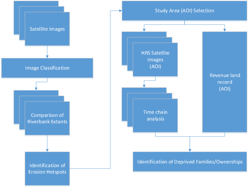
Figure 1. Flow Diagram
Presently, RS is a very powerful tool for river morphological study and remotely sensed data from satellites provides information not only about river channel configuration but also brings many facts about changes in river morphology as well [8]. Satellite RS can play a critical role in determining different forms of damage [9]. These days, many satellite datasets are available at no cost. Landsat satellite imagery is also globally famous for its free sourcing and being used in different ways in multiple sectors [10]. Here, we have also used Landsat satellite images to study the Chenab river's morphological change with time. Landsat satellite has coarse spatial resolution i.e.30m but good enough to work on larger geographic areas. Landsat satellite images from the years 2009, 2013 and 2017 have used for the said purpose. For better precision, satellite images from same satellite and similar dates from repeated intervals should be used [11].
- Study area
The study falls along the Chenab River within District Hafizabad. District Hafizabad is located at 32.07 N, 73.68 E in Punjab province of Pakistan. Its district boundary from North-East to South-West separates Mandi Bahauddin, Sargodha, and Chiniot districts along the Chenab River. The length of the Chenab River being hosted by the District Hafizabad is almost 67km out of the 101km long shared boundary with its aforementioned neighboring districts.
The Area of Interest (AOI) along the Chenab River inside District Hafizabad is highlighted with the red color rectangle in figure 2 below:

Figure 2. AOI of the Area
Satellite images classification
Object-Based Image (OBI) Classification technique has applied to aforementioned periods’ Landsat satellite images to find out the river course change occurred with the time frame.
The separate results of the Chenab river course observed for years 2009, 2013 and 2017 are as shown below in figure 3:
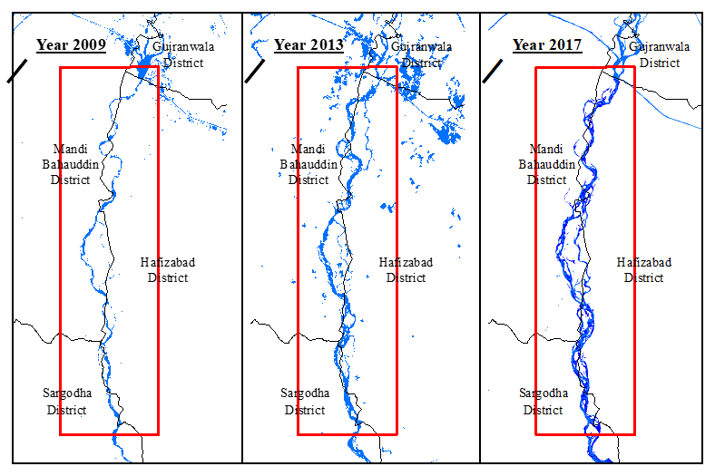
Figure 3. Chenab River channel course by the time
Riverbank extent comparison
The comparative picture of all three years’ results is shown in figure 4 below:
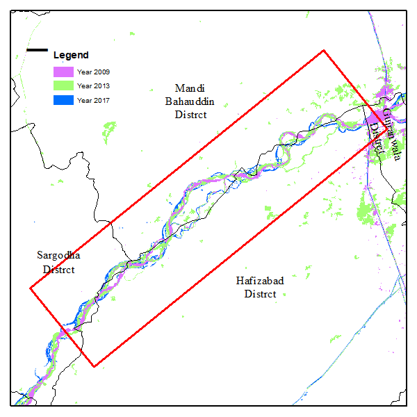
Figure 4. River course for years 2009, 2013 & 2017
Above, figure 4 is important to identify the hotspots in AOI where river course change may be more prominent with rapid change rate and helps to find valuable locations. RS and GIS are efficient tools for change detection [12]. For a layman, change in the river course is just morphological change but in reality, it disturbs the fertile land and leaves concerned families deprived. Riverbank erosion causes destroyed land, livelihood and eventually compelled the people to migrate [13, 14].
The fertile lands destructed by this phenomenon can be identified and such deprived families may be verified scientifically. This study will further focus on the identification of such deprived families through revenue records. For this purpose, there is a need to select one of the hotspots from our AOI as shown in figure 5 below:
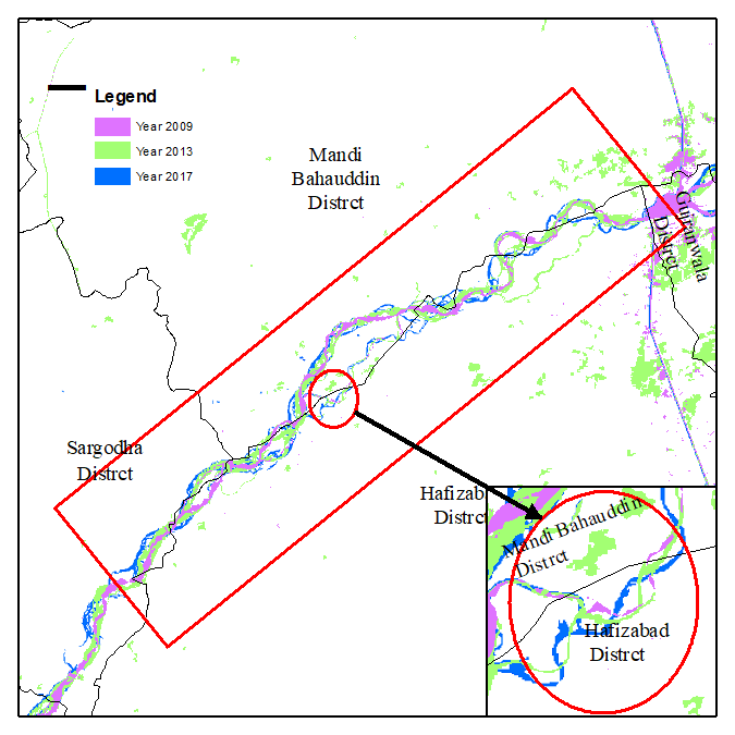
Figure 5. A selected hotspot for identification of deprived families
Erosion hotspots
River erosion is the process of changing river-bed and banks with the time passage. Erosion hotspots/vulnerable points are those locations where riverbank change is visible and it can be observed by comparing riverbank lines for at least two different periods.
In figure 5 above, supports the identification of the river erosion hotspots. Here to proceed, only a single hotspot in District Hafizabad, “Chak Bhatti” along the Chenab River (left bank) has been selected for detailed working. This position is available at 73.39 E, 32.16 N.
Revenue land record
For precise identification of deprived families due to river erosion phenomena, there is a need to register the revenue land record document (Massavi map, contains individuals’ land ownership information). It is possible to make geo-referencing of Massavi map, applying the GIS techniques [15,16]. For the said purpose, the Massavi map of “Chak Bhatti” (shown in figure 6 below) can be geo-tagged and the processed Massavi map results are shown in figure 7 below:
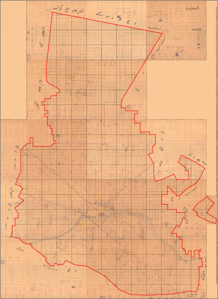
Figure 6. Massavi map (revenue record) of Chak Bhatti, District Hafizabad
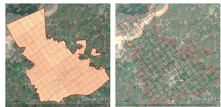
Figure 7 and figure 8. are showing comparative pictures and ground linear features can be matched easily for evaluation as well.
Analysis
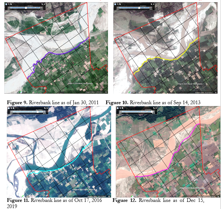
More than 75% of the world’s Ice-free land showed evidence of human alteration as a result of shelter and land-use activities [17]. Riverbank erosion causes may be natural and/or human. Riverbank erosion has negative impacts on human life, conversely human activity has a negative impact on riverbank erosion [18]. The erosion phenomenon shapes our riverbanks which depends on river water level and soil properties [19]. To understand the actual changing ground situation due to riverbank erosion with the time can be determined through high-resolution satellite imagery. Google earth’s “Show Historical Images” tool has been used for highlighting the situation and time to time change found in riverbank displacement is as shown below:
- Results & discussion
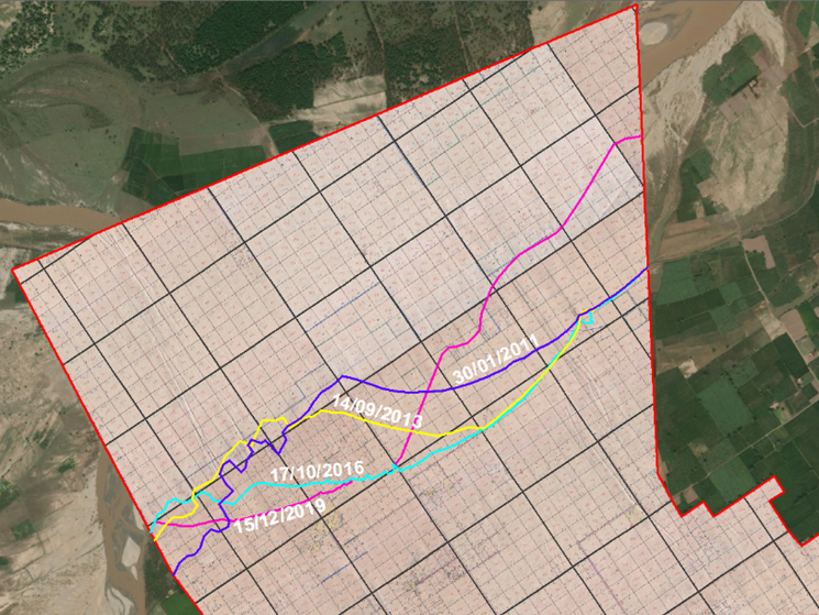
A complete comparison of all time riverbank shifts has (separately shown above in figure 9, 10, 11 & 12) displayed in figure 13 below:

Figure 13. All time riverbank shifts’ comparison
|
162m |
Figure 14. All-time riverbank shifts along with Massavi map (revenue record-keeping document)
Figure 13 shows that how the riverbank is eroding land with time, it also shows that riverbank displacement from 2013-16 is more than any other span which reflects the effect of 2014’s super flood faced during this period. The joining points of riverbank displacement lines between 2013-16 and 2016-19 show 448m and 162m shift in South-West along with the river flow, respectively. This shows that the average riverbank displacement due to erosion phenomenon at this location was 12.1m/month and 4.4m/month during 2013-16 and 2016-19, respectively. The victims face economic, social and health insecurities and make families’ life more vulnerable [20], however, regular monitoring of riverbank erosion values and soil degradation can help to foresee the situation [21]. Families settled along the riverbank used to face many problems in their daily life due to issues like frequent floods and riverbank erosion [22]. On the other hand, bad governance also acts as a catalyst for the miseries of the affected community [23]. Therefore, it is needed to monitor the erosion phenomenon on regular basis to save the vulnerable communities otherwise it may turn to serious consequences as well [24]. Many remedial measures may be taken including concretization, plantation, desilting, use of nut-fibers and synthetic erosion-resistant mats [25]. Soil can be divided into different types based on erosion rate and accordingly plantation plans can be suggested, like land with heavy grade erosion can be planted by sugarcane and with low grade erosion can be corn or rice [26].
Table 1. Land losses in different years
|
Image Date |
Total Area Eroded |
|
|
Sq Meter |
Acre |
|
|
1/30/2011 |
2,305,246.5 |
569.6 |
|
9/14/2013 |
2,376,378.4 |
587.2 |
|
10/17/2016 |
2,542,732.1 |
628.3 |
|
12/15/2019 |
2,203,017.5 |
544.4 |
The table 1 is showing the information regarding capture dates of different satellite images used in this study and the submerged area of Chak Bhatti on the given date. The results shown in this table describe that on 30th January 2011, the eroded area of Chak Bhatti due to riverbank erosion was 569.6 acres while on 14th September 2013 the submerged/eroded area was increased to 17.6 acres, leaving total of 587.2 acres of area eroded. Similarly, as on 17th October 2016 the submerged/eroded area of Chak Bhatti kept on damaging land in Chak Bhatti with increase of 41.1 acres during the period of almost 3 years and hence the total eroded area increased to 628.3 acres and the further analysis shows that on 15th December 2019, the riverbank shifted its mender to leave some submerged area of Chak Bhatti to dry part which resulted as decrease of 83.9 acres, keeping total of 544.4 acres submerged.
The implementation of modern techniques (like RS and GIS) is not only greatly helps to study the riverbank erosion phenomenon but also be very precise to accurately identify the affected landowners. Figure 14 is self-explanatory to identify such ownerships as geo-referenced revenue land record has shown with the time-to-time riverbank displacement extents which geo-tags all the affected ownerships very precisely. This study at work has multiple benefits in the larger disaster management realm, but more specifically it is highly useful in:
- Precision land loss and reclamation estimations due to riverbank erosion phenomenon
- Devising prompt and efficient relief packages for the riverbank erosion affectees by relief agencies
- Enhanced disaster preparedness levels at the community and government levels.
- Adaptation of the riverbank erosion phenomenon, sometimes these are beyond our control and means.
It has also been observed that the victims of the riverbank erosion phenomenon are not provided any compensation against their eroded lands which of course pushes the victimized families to financial stress. Because of the above findings, the study also suggests a suitable scientific-based stipend for the victimized families, since water charges (Aabiyana) are being collected by the government from other harvesters and this availability of water for the crops is being made possible through such affected owner’s private lands, as well.
Conflict of interest. Authors are advised to explain that there exists no conflict of interest for publishing this manuscript in IJIST.
REFRENCES
-
- Ahmed, A. A. and A. Fawzi, "Meandering and Bank Erosion of the River Nile and Its Environmental Impact on the Area Between Sohag and El-Minia, Egypt." Arabian Journal of Geosciences, (2011) 04: 01-11.
- Raza, M. T., Chenab Erosion Eats Away 200 Houses, (2015), https://dawn.com/news/1170268, LastAccessDate: April 15, 2020
- Chaudhry, F., Erosion Makes People Homeless, (2016) https://dawn.com/news/1285296, LastAccessDate: April 15, 2020
- Dabojani, D., et al. (2014). River Change Detection and Bankline Erosion Recognition using Remote Sensing and GIS. Forum Geografic.
- Nath, B., et al., "Trends Analysis of River Bank Erosion at Chandpur, Bangladesh: A Remote Sensing and GIS Approach." International Journal of Geomatics and Geosciences (2013), 3(3): 454-463.
- Aher, S. P., et al., "River Change Detection and Bank Erosion Identification Using Topographical and Remote Sensing Data." International Journal of Applied Information Systems (2012), 02(03): 01-07.
- Lam-Dao, N., et al., "Change Detection of Land Use and Riverbank in Mekong Delta, Vietnam Using Time Series Remotely Sensed Data." Journal of Resources and Ecology (2011) 2(4): 370-375.
- Sarkar, A., et al., "RS-GIS Based Assessment of River Dynamics of Brahmaputra River in India. " Journal of Water Resource and Protection (2012), 4(02): 63.
- Casana, J., "Satellite Imagery-Based Analysis of Archaeological Looting in Syria." Near Eastern Archaeology (2015), 78(03): 142-1
- Miller, H. M., et al., Users, Uses, and Value of Landsat Satellite Imagery-Results from the 2012 Survey of Users: 01-51 (2013)
- Uddin, K., et al., "Assessment of morphological changes and vulnerability of river bank erosion alongside the river Jamuna using remote sensing." Journal of Earth Science and Engineering (2011) 1(1): 29-34.
- Dhara, S. and B. K. Mondal, "River Bank Erosion and Changing Course of River Saptamukhi and Muriganga of Namkhana Island." West Bengal: Geoinformatics for Sustainable Environment Management (2019) II: 161-170.
- Kamal, M. and M. J. Abedin, "Riverbank Erosion and Migration: A Study on Displaced People from Governance and Cultural Perspective." Society & Change (2019) XIII(04): 23-34.
- Rafatullah, N. I. and K. Hossain, "Socio-Economic Vulnerability of Riverbank Erosion of Displacees: Case Study of Coastal Villages in Bangladesh." Indian Journal of Ecology (2019), 46(1): 34-38.
- Aslam, R. M. S., et al., "Baseline Data Preparation of Revenue Land Record." International Journal of Scientific and Engineering Research (2015), 06(08): 1792-1799.
- Masood, A., et al., Precise Extraction of Village Boundary from Revenue Massavi Maps Using GIS/RS Techniques. (2019) 2nd International Congress on Earth Sciences, Nusa Dua Bali, Indonesia.
- Ellis, E. C. and N. Ramankutty, "Putting People in the Map: Anthropogenic Biomes of the World." Frontiers in Ecology and the Environment (2008), 6(8): 439-447.
- Tripathy, B. and T. Mondal, "Impact of Riverbank erosion on Human life." Thematics Journal of Geography (2019), 8(9): 53-56.
- Duong Thi, T. and D. Do Minh, "Riverbank Stability Assessment under River Water Level Changes and Hydraulic Erosion." (2019) Water 11(12): 2598.
- Das, T. K., et al., "River Bank Erosion Induced Human Displacement and Its Consequences." Living Review of Landscape Research (2014) 8(3): 01-35.
- Durlević, U, et al., "Multihazard susceptibility assessment: A case study – Municipality of Štrpce (Southern Serbia)" (2021) Open Geosciences, vol. 13, no. 1, 2021, pp. 1414-1431.
- Kundu, R. R., et al., Resilience of Riverine Households towards Dynamic Vulnerability. International Conference on Agriculture and Allied Sciences: The Productivity, Food Security and Ecology New Delhi, India. (2018) 15: 27-31.
- Munna, G. M., et al., "Assessment of Socio-Economic Impacts of Surma River Bank Erosion by Using GIS & Statistical Study." International Journal of Science and Engineering Invention (2020) 6(01): 01-04.
- Lovric, N. and R. Tosic, "Assessment of Bank Erosion, Accretion and Channel Shifting Using Remote Sensing and GIS: Case Study–Lower Course of the Bosna River." Quaestiones Geographicae (2016) 35(1): 81-92.
- Chatterjee, S. and B. Mistri, "Impact of River Bank Erosion on Human Life: A Case Study in Shantipur Block, Nadia District, West Bengal." International Journal of Humanities and Social Science Invention (2013), 02(08): 108-111.
- Belo, D. X. A., et al., "Analysis of Land Erosion Due to Mining of Clay Material in Sidorejo Village, Sleman District, Yogyakarta." Geographia Technica (2020) 15(Special): 33-41.


