
Spatial Dynamics of Flood Hazard and Vulnerability: A Geostatistical and Google Earth Engine Approach in Eastern Kasur, Pakistan
Keywords:
Flood Hazard, Eastern Kasur, GEE, Sentinel, Spatial Clustering, Vulnerability, ResilienceAbstract
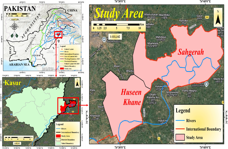
Floods are among the most recurrent and destructive natural hazards, particularly in monsoon-dominated regions. This study presents a geospatial and geostatistical assessment of flood hazard, vulnerability, and resilience in eastern Kasur District, Pakistan, along the Sutlej River. A total of 150 households were surveyed using stratified random sampling, and results were integrated with Sentinel-1 and Sentinel-2 satellite imagery processed in Google Earth Engine (GEE). Spatial techniques, including Inverse Distance Weighted (IDW) interpolation, Anselin Local Morans I, Spatial Autocorrelation (Morans I) and linear regression, were applied. Results indicate that 17 km² of land was inundated, with agriculture accounting for 87.18% of the affected area, followed by built-up land (4.45%). Significant spatial clustering was observed for key vulnerability indicators, including household damage (Moran’s I = 0.29, p < 0.001) and agricultural land erosion (Moran’s I = 0.354, p < 0.000001). Economic losses reached PKR 250,000–400,000 per household, with income reductions up to 75%, while post-flood inflation exceeded 50% in hotspot areas. Regression analysis showed moderate spatial dependence (R² = 0.1362 and 0.1235), indicating both spatial and local drivers of vulnerability. Hotspot analysis identified Sahgerah, Wallay Wala, Ullanke & Jumeke, Maste Ki, Chanda Singh Wala, and Nagar Amanpura as high-risk clusters exhibiting multi-dimensional vulnerability. The Random Forest classifier demonstrated strong performance, achieving an overall accuracy of 86% and a Kappa coefficient of 0.82. The study demonstrates that integrating geostatistics with cloud-based remote sensing enables precise identification of flood vulnerability hotspots and supports targeted, data-driven flood risk management strategies.
References
A. David Raj and A. David Raj, “Climate Change Induced Hydro-Meteorological Extremes in the Himalayan Region,” pp. 33–56, 2025, doi: 10.1007/978-3-031-85359-3_2.
Dr Chrysanthus Chukwuma Sr, “Invariance of Extreme Hydrologic Events and Climate Change in the Risk Reduction on Environment and Health,” Greenfort Int. J. Appl. Med. Sci., vol. 3, no. 2, pp. 92–102, 2025, doi: 10.62046/gijams.2025.v03i02.011.
Xiaojing Sun, Ruonan Li, “Assessment of climate change impacts and urban flood management schemes in central Shanghai,” Int. J. Disaster Risk Reduct., vol. 65, p. 102563, 2021, doi: https://doi.org/10.1016/j.ijdrr.2021.102563.
Santiago X. Núñez Mejía, Santiago Mendoza Paz, “Climate change impacts on hydrometeorological and river hydrological extremes in Quito, Ecuador,” J. Hydrol. Reg. Stud., vol. 49, p. 101522, 2023, doi: https://doi.org/10.1016/j.ejrh.2023.101522.
Andreas N. Angelakis, Andrea G. Capodaglio, “Evolution of Floods: From Ancient Times to the Present Times (ca 7600 BC to the Present) and the Future,” Land, vol. 12, no. 6, p. 1211, 2023, doi: 10.3390/land12061211.
Robindro Singh Khwairakpam; Sananda Kundu, “Enhanced flood quantile estimation and its implications in rainfall–discharge relationship during flood events in Brahmani-Baitarani River basin, India,” Water Pract. Technol., vol. 12, no. 1, pp. 192–222, 2026, doi: https://doi.org/10.2166/wpt.2026.190.
Martina Angela Caretta, Rodrigo Fernandez, “Flooding Hazard and Vulnerability. An Interdisciplinary Experimental Approach for the Study of the 2016 West Virginia Floods,” Front. water, vol. 3, 2021, doi: https://doi.org/10.3389/frwa.2021.656417.
Konstantinos M Andreadis, Oliver E J Wing, Emma Colven, Colin J Gleason, Paul D Bates and Casey M Brown, “Urbanizing the floodplain: global changes of imperviousness in flood-prone areas,” Environ. Res. Lett., vol. 17, no. 10, p. 104024, 2022, [Online]. Available: https://iopscience.iop.org/article/10.1088/1748-9326/ac9197
M. M. Q. Mirza, “Climate change, flooding in South Asia and implications,” Reg. Environ. Chang. 2010 111, vol. 11, no. 1, pp. 95–107, Dec. 2010, doi: 10.1007/S10113-010-0184-7.
Shuainan Liu, Yang Liu, “Flood Risk Assessment in the Greater Bay Area Based on Multidimensional Dynamic Data,” Int. Arch. Photogramm. Remote Sens. Spat. Inf. Sci., pp. 189–195, 2025, doi: 10.5194/isprs-archives-XLVIII-4-W14-2025-189-2025.
W. Duan and K. Takara, “Impacts of Climate and Human Activities on Water Resources and Quality: Integrated Regional Assessment,” Impacts Clim. Hum. Act. Water Resour. Qual. Integr. Reg. Assess., pp. 1–183, Jan. 2020, doi: 10.1007/978-981-13-9394-5/COVER.
S. Srivastava, T. Gerdes, and T. Roy, “County-scale flood risk assessment of properties and associated population in the United States,” Nat. Hazards, vol. 121, no. 3, pp. 2641–2664, Feb. 2025, doi: 10.1007/S11069-024-06892-8.
“Climate change and water security in the Indo-Pacific region: Risks, responses, and a framework for action | Asia and the Pacific Water Resilience Hub.” Accessed: Apr. 07, 2026. [Online]. Available: https://hub4r.adb.org/index.php/node/1421
Abid Nazir, Awais Ahmad, “Flood-Induced Agricultural Damage Assessment: A Case Study of Pakistan,” Water, vol. 17, no. 21, p. 3060, 2025, doi: https://doi.org/10.3390/w17213060.
B. B. Shreevastav, “Flood Scenario and its Risk Management, Policy, Practices in Nepal,” Int. J. Sci. Eng. Res., vol. 10, no. 4, pp. 571–581, Apr. 2019, doi: 10.14299/IJSER.2019.04.07.
A. Inam et al., “The Geographic, Geological, and Oceanographic Setting of the Indus River – An Update,” Large Rivers Geomorphol. Manag., pp. 488–520, Apr. 2022, doi: 10.1002/9781119412632.CH17.
Leanne Hauptman, Diana Mitsova, “Hurricane Ian Damage Assessment Using Aerial Imagery and LiDAR: A Case Study of Estero Island, Florida,” J. Mar. Sci. Eng, vol. 12, no. 4, p. 668, 2024, doi: https://doi.org/10.3390/jmse12040668.
Mustafa Javed, Jürgen Böhner & Shabeh ul Hasson, “Streamflow projections for the Jhelum River basin under climate change,” Discov. Appl. Sci., vol. 7, 2025, [Online]. Available: https://link.springer.com/article/10.1007/s42452-025-06721-y
S. Haider, M. U. Masood, A. A. Awan, R. Z. N. Khan, and M. Rashid, “Understanding Climate Change Impacts on Coastal Communities: Resilience, Adaptation, and Sustainable Development in Sindh, Pakistan,” pp. 391–423, 2025, doi: 10.1007/978-981-96-1733-3_18.
“A historical appraisal of the water dispute in the Indus Basin, 1947-1960 - UUM Electronic Theses and Dissertation [eTheses].” Accessed: Mar. 26, 2026. [Online]. Available: https://etd.uum.edu.my/8713/
Y. V. S. Bhageerath, A. V. S. Babu, K. H. V. D. Rao, K. Sreenivas, and P. Chauhan, “Flood period estimation using multi-sensor satellite data: Case study on Punjab floods 2023,” J. Earth Syst. Sci. 2025 1341, vol. 134, no. 1, pp. 43-, Feb. 2025, doi: 10.1007/S12040-024-02499-6.
D. Glover, “Exploring the Resilience of Bt Cotton’s ‘Pro-Poor Success Story,’” Dev. Change, vol. 41, no. 6, pp. 955–981, Dec. 2010, doi: 10.1111/J.1467-7660.2010.01667.X;ISSUE:ISSUE:DOI.
“Floods: Governance Challenges and the Roots of Repeated Climate Disasters in Pakistan (part II) – SLD.” Accessed: Mar. 26, 2026. [Online]. Available: https://sld.com.pk/2025/07/24/floods-governance-challenges-and-the-roots-of-repeated-climate-disasters-in-pakistan-part-ii/
R. Looney, “Economic impacts of the floods in Pakistan,” Contemp. South Asia, vol. 20, no. 2, pp. 225–241, Jun. 2012, doi: 10.1080/09584935.2012.670203.
S. Kondapalli, “The geo-politics of the Indo-Pacific: Perceptions, opportunities, and challenges,” New World Polit. Indo-Pacific Perceptions, Policies Interes., pp. 16–33, Jun. 2024, doi: 10.4324/9781003479307-3/GEO-POLITICS-INDO-PACIFIC-SRIKANTH-KONDAPALLI.
UNDRR (United Nations Office for Disaster Risk Reduction), “Global Assessment Report on Disaster Risk Reduction (GAR),” 2022, [Online]. Available: https://www.undrr.org/gar
I. Khan, A. Ullah, A. Z. Zaidi, and V. Panhwar, “Assessing glacial lake outburst flood potential using geospatial techniques: a case study of western part of Gilgit-Baltistan, Pakistan,” Arab. J. Geosci. 2022 161, vol. 16, no. 1, pp. 1–12, Dec. 2022, doi: 10.1007/S12517-022-11088-0.
Peng Cui, Nazir Ahmed Bazai, Zou Qiang, Wang Jiao, Wang Yan, Qingsong Xu, Lei Yu & Zhang Bo, “Flood risk assessment with machine learning: insights from the 2022 Pakistan mega-flood and climate adaptation strategies,” npj Nat. hazards, 2025, [Online]. Available: https://www.nature.com/articles/s44304-025-00096-1
M. R. Akram, “Transboundary flood and drought challenges: a case study of the Sutlej River in Pakistan,” Int. J. River Basin Manag., Jun. 2025, doi: 10.1080/15715124.2025.2512955.
“Spatial Analysis of Urban Flood Vulnerability Using Weighted Overlay Technique For Identification of Hazard Zones In Greater Jakarta.” Accessed: Mar. 26, 2026. [Online]. Available: https://www.researchgate.net/publication/392691295_SPATIAL_ANALYSIS_OF_URBAN_FLOOD_VULNERABILITY_USING_WEIGHTED_OVERLAY_TECHNIQUE_FOR_IDENTIFICATION_OF_HAZARD_ZONES_IN_GREATER_JAKARTA
M. Aliyu, A. A. Dandajeh, S. B. Igboro, and N. I. Abdullahi, “Flood Hazard Assessment and Mapping in River-Rima Floodplain, Birnin Kebbi-Nigeria,” Niger. J. Technol. Dev., vol. 22, no. 1, pp. 279–293, Mar. 2025, doi: 10.4314/NJTD.V22I1.2862.
M. M. Islam, S. Matsushita, R. Noguchi, and T. Ahamed, “A damage-based crop insurance system for flash flooding: a satellite remote sensing and econometric approach,” Asia-Pacific J. Reg. Sci. 2021 61, vol. 6, no. 1, pp. 47–89, Nov. 2021, doi: 10.1007/s41685-021-00220-9.
Mohammad Zahednia, Shirin Shirazian, “Identifying the causes of floods and assessing the resulting environmental damage to provide a flood compensation model,” Anthropog. Pollut., vol. 9, no. 1, 2025, [Online]. Available: https://oiccpress.com/ap/article/view/17277
P. Mishra and S. K. Prasad, “Lightweight Hybrid Deep Learning and Fuzzy-AHP Framework for Predictive Flood Susceptibility Mapping in the Ghaghara River Basin, India: A Data-Driven Approach for Enhanced Spatiotemporal Precision and Risk Prediction,” Earth Syst. Environ. 2026, pp. 1–28, Jan. 2026, doi: 10.1007/S41748-025-00970-Y.
Rakhee Ramachandran, Yadira Bajón Fernández, “Accuracy Assessment of Surveying Strategies for the Characterization of Microtopographic Features That Influence Surface Water Flooding,” Remote Sens., vol. 15, no. 7, p. 1912, 2023, doi: 10.3390/rs15071912.
S. Puttinaovarat, A. Saeliw, S. Pruitikanee, J. Kongcharoen, S. Chai-Arayalert, and K. Khaimook, “Flood Damage Assessment Geospatial Application Using Geoinformatics and Deep Learning Classification,” Int. J. Interact. Mob. Technol., vol. 16, no. 21, pp. 71–97, 2022, doi: 10.3991/ijim.v16i21.34281.
Aslam A. Al-Omari, Nawras N. Shatnawi, “Utilizing Remote Sensing and GIS Techniques for Flood Hazard Mapping and Risk Assessment,” Civ. Eng. J., vol. 10, no. 5, 2024, [Online]. Available: https://www.civilejournal.org/index.php/cej/article/view/4836
M. A. R. Khan, M. A. Rouf, N. Sultana, and M. S. Akter, “Development of A Fog Computing-Based Real-Time Flood Prediction And Early Warning System Using Machine Learning And Remote Sensing Data,” J. Sustain. Dev. Policy, vol. 01, no. 01, pp. 144–169, Mar. 2025, doi: 10.63125/6y0qwr92.
Y. Hasnaoui et al., “Integrated Remote Sensing and Deep Learning Models for Flash Flood Detection Based on Spatio-temporal Land Use and Cover Changes in the Mediterranean Region,” Environ. Model. Assess. 2025 305, vol. 30, no. 5, pp. 1013–1035, May 2025, doi: 10.1007/s10666-025-10035-z.
C. Campo, P. Tamagnone, S. Choy, T. D. Tran, G. J.-P. Schumann, Y. Kuleshov, “Monitoring Flood Inundation Dynamics From Space,” Rev. Geophys., 2026, doi: https://doi.org/10.1029/2025RG000885.
S. Martinis, M. Wieland, M. Rattich, C. Bohnke, and T. Riedlinger, “Automatic Near-Real Time Flood Extent and Duration Mapping based on Multi-Sensor Earth Observation Data,” Int. Geosci. Remote Sens. Symp., pp. 3243–3246, Sep. 2020, doi: 10.1109/IGARSS39084.2020.9324295.
Sona Guliyeva & Piero Boccardo, “Geospatial Technologies for Flood and Drought Management: A Review of Earth Observation Data, Procedures, and their Operational Effectiveness,” Aerotec. Missili Spaz., 2026, [Online]. Available: https://link.springer.com/article/10.1007/s42496-026-00309-4
Angelica Tarpanelli, Christian Massari, Beatriz Revilla-Romero, Mohammad J. Tourian, “The Potential of EO Data for Enhanced Flood Monitoring and Forecasting: A Consortium Assessment,” Surv. Geophys., vol. 47, pp. 317–358, 2026, [Online]. Available: https://link.springer.com/article/10.1007/s10712-026-09935-w
M. S. Mirza Waleed, “High-resolution flood susceptibility mapping and exposure assessment in Pakistan: An integrated artificial intelligence, machine learning and geospatial framework,” Int. J. Disaster Risk Reduct., vol. 121, p. 105442, 2025, doi: https://doi.org/10.1016/j.ijdrr.2025.105442.
Xiaoyi Liu, Hichem Sahli, “Flood Inundation Mapping from Optical Satellite Images Using Spatiotemporal Context Learning and Modest AdaBoost,” Remote Sens., vol. 9, no. 6, p. 617, 2017, doi: https://doi.org/10.3390/rs9060617.
Yayi Zhang, Yongqiang Wei, “Data Uncertainty of Flood Susceptibility Using Non-Flood Samples,” Remote Sens., vol. 17, no. 3, p. 375, 2025, doi: 10.3390/rs17030375.
Tianlian Wang, Zhiyuan Fu, “Deep learning for decoding climate–urbanization synergies: flood susceptibility forecasting under SSP-RCP scenarios in Beijing, China,” J. Hydrol., vol. 672, 2026, doi: 10.1016/j.jhydrol.2026.135364.
VELASQUEZ HURTADO, WILSON ANDRES, “Data Fusion and change detection techniques based on optical and Synthetic Aperture Radar satellite imagery for damage mapping and multi-temporal assessment of the recovery and reconstruction process after natural disasters,” Tesi di dottorato, 2026, [Online]. Available: https://tesidottorato.depositolegale.it/handle/20.500.14242/357518
Antonika Shapovalova, “Flood Radar: Multi-Sensor SAR-Based Flood Mapping and Evacuation Modeling — A Case Study of the July 2025 Texas Flood,” Researchgate, 2025, [Online]. Available: https://www.researchgate.net/publication/397419938_Flood_Radar_Multi-Sensor_SAR-Based_Flood_Mapping_and_Evacuation_Modeling_-_A_Case_Study_of_the_July_2025_Texas_Flood
M. A. Al Sayeem and R. B. Rahman, “A Cloud-Based Sentinel-1 SAR and Sentinel-2 Optical Approach for Rapid Flood Mapping and Impact Assessment: Application to the 2022 Sylhet District Flood, Bangladesh,” 2026, doi: 10.2139/SSRN.6142670.
Benedikt Mester, Katja Frieler, “Socioeconomic predictors of vulnerability to flood-induced displacement,” Nat. Commun., vol. 16, 2025, [Online]. Available: https://pmc.ncbi.nlm.nih.gov/articles/PMC12441118/
Bingyan Ma, Jing Guo, “Comprehensive risk assessment of urban floods based on flood simulation and socio-economic vulnerability,” Front. Earth Sci., vol. 13, 2025, doi: https://doi.org/10.3389/feart.2025.1645693.
Muhammad Ahsan Mukhtar, Donghui Shangguan, “Integrated flood risk assessment in Hunza-Nagar, Pakistan: unifying big climate data analytics and multi-criteria decision-making with GIS,” Front. Enviromental Sci., vol. 12, 2024, doi: https://doi.org/10.3389/fenvs.2024.1337081.
Chengjie Zhou, Hanru Shen, “A spatial-explicit analysis of influencing factors of observed floods in the Yangtze River Delta, China,” Landsc. Ecol., vol. 40, no. 9, 2025, doi: 10.1007/s10980-025-02201-1.
H. Uyguçgil, “Rapid Flash Flood Mapping Using Sentinel-1 SAR Data on the Google Earth Engine Platform,” Int. J. Environ. Geoinformatics, vol. 4, no. 12, pp. 408–414, Jan. 2026, doi: 10.26650/ijegeo.1650297.
F. Arshad et al., “Indigenous farmer’s perception about fodder and foraging species of Semi-arid lowlands of Pakistan: A case study of District Kasur, Pakistan,” Taiwania, vol. 67, no. 4, pp. 510–523, 2022, doi: 10.6165/TAI.2022.67.510.
Muhammad Waheed, Shiekh Marifatul Haq, “Grasses in Semi-Arid Lowlands—Community Composition and Spatial Dynamics with Special Regard to the Influence of Edaphic Factors,” Sustainability, vol. 14, no. 22, p. 14964, 2022, doi: 10.3390/su142214964.
Muhammad Saiful Ruuhulhaq, Arif Rohman, “Exploring Google Earth Engine for Flood Detection (A Case Study in Bandung City),” Int. J. Disaster Dev. Interface, vol. 5, no. 1, pp. 223–245, 2025, doi: 10.53824/ijddi.v5i1.93.
B. Bilal, R. Saleemi, A. Amer, and H. Gulzar, “Remote Sensing and Machine Learning-Driven Flood Inundation Mapping of September 2025 Ravi Watershed Using Sentinel-1 SAR,” Int. J. Innov. Sci. Technol., vol. 7, no. 4, pp. 2338–2350, 2025, Accessed: Apr. 07, 2026. [Online]. Available: https://ideas.repec.org/a/abq/ijist1/v7y2025i4p2338-2350.html
“Sentinel-1 – Documentation.” Accessed: Apr. 07, 2026. [Online]. Available: https://documentation.dataspace.copernicus.eu/Data/SentinelMissions/Sentinel1.html
N. Gorelick, M. Hancher, M. Dixon, S. Ilyushchenko, D. Thau, and R. Moore, “Google Earth Engine: Planetary-scale geospatial analysis for everyone,” Remote Sens. Environ., vol. 202, pp. 18–27, Dec. 2017, doi: 10.1016/J.RSE.2017.06.031.
A. M. Abdi, “Land cover and land use classification performance of machine learning algorithms in a boreal landscape using Sentinel-2 data,” GIScience Remote Sens., vol. 57, no. 1, pp. 1–20, Jan. 2020, doi: 10.1080/15481603.2019.1650447.
Afshin Akram, Arifa Tahir, “GIS based flood extent assessment using MODIS satellite remote sensing and spatial analysis,” Front. Earth Sci., vol. 12, 2024, doi: https://doi.org/10.3389/feart.2024.1309629.
Rana Muhammad Amir Latif, Jinliao He, “Flood Susceptibility Mapping in Punjab, Pakistan: A Hybrid Approach Integrating Remote Sensing and Analytical Hierarchy Process,” Atmosphere (Basel)., vol. 16, no. 1, p. 22, 2025, doi: https://doi.org/10.3390/atmos16010022.
Tania Islam, Ethiopia B. Zeleke, Mahmud Afroz, “A Systematic Review of Urban Flood Susceptibility Mapping: Remote Sensing, Machine Learning, and Other Modeling Approaches,” Remote Sens, vol. 17, no. 3, p. 524, 2025, doi: https://doi.org/10.3390/rs17030524.
Izhar Ahmad, Rashid Farooq, Muhammad Ashraf, Muhammad Waseem & Donghui Shangguan, “Improving flood hazard susceptibility assessment by integrating hydrodynamic modeling with remote sensing and ensemble machine learning,” Nat. Hazards, vol. 121, 2025, [Online]. Available: https://link.springer.com/article/10.1007/s11069-025-07109-2
Downloads
Published
How to Cite
Issue
Section
License
Copyright (c) 2026 50sea

This work is licensed under a Creative Commons Attribution 4.0 International License.


