
Spatio-Temporal Analysis of Land Use Land Cover Dynamics, Synergy of Land Surface Temperature and Snow Cover Fluctuations in Gilgit River Basin, North Pakistan
Keywords:
Land Surface Temperature, Snow Cover Dynamics, Remote Sensing, Google Earth Engine, Climate Change, Gilgit River BasinAbstract
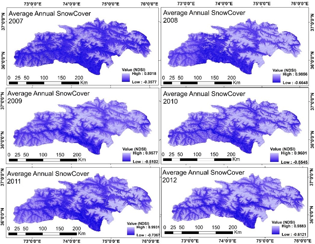
This study explores the spatio-temporal dynamics of Land Use Land Cover (LULC), Land Surface Temperature (LST) and snow cover in the Gilgit River Basin (GRB), North Pakistan during the period 1995-2024 using remote sensing and GIS technologies. Multi-temporal Landsat satellite imagery (Landsat 5, 7, 8 and 9) was applied through Google Earth Engine (GEE) to analyze LULC changes, relationship of LST and snow cover variability. Supervised classification i.e. random forest algorithm revealed significant LULC transformations. Settlement expansion shows, rapid increases were recorded in urban sprawl and population growth (+6,736.92 ha). These changes in built-up area are concentrated in areas under farmland. This is because of the conversion of vegetation cover and agricultural land into built-up areas. In the context of vegetation cover, the region observed the degradation in area under forest cover and loss of agricultural land (-43,676.09 ha). Similarly, in case of snow cover, critical changes were observed (-169,211.68 ha). The resultant values illustrate glaciers retreat along with limited snow accumulation. This is largely attributed to climatic change and rising temperature in the HKH region. As a result, it has a direct impact on river discharge and water security. Furthermore, growth in barren land (+203,535.44 ha), where positive changes in almost all the land use classes. Consequently, desertification, land degradation and loss of snow and vegetation cover occurred. Additionally, slight rise has been seen in water bodies such as +86.74 ha and the minor changes are due to glacial melting which temporarily increases the surface water. As a result, small lakes i.e. glacial and glacio-fluvial lakes were also developed. The analysis revealed that LST exhibited a strong warming trend (+0.17°C/year, *p* < 0.0001), with Monte Carlo simulations confirming its robustness (95% CI: +0.12°C to +0.22°C/year). Whereas, the snow cover declined markedly (−137.5 km²/year, *p* < 0.0001), showing a strong inverse correlation with LST_max (*r* = −0.897, *p* = 0.000). The Mann-Kendall (MK) test and Pearson Correlation (PC) highlighted the climate-driven reduction in snow cover and its linkage to rising temperature. The key findings underscore the basin’s vulnerability to climate change having significant implications for water security, hydrology and ecosystems. The study recommends integrated water management, land use regulations and climate-resilient agriculture to mitigate its adverse impacts. This research contributes to understanding elevation-dependent warming in mountainous regions and also to support policy formulation for sustainable resource management in the Upper Indus Basin.
References
A. A. Mohamed, J. Odindi, and O. Mutanga, “Land surface temperature and emissivity estimation for Urban Heat Island assessment using medium- and low-resolution space-borne sensors: A review,” Geocarto Int., vol. 32, no. 4, pp. 455–470, Apr. 2017, doi: 10.1080/10106049.2016.1155657.
Sajjad Hussain, Shankar Karuppannan, “Land use/land cover changes and their impact on land surface temperature using remote sensing technique in district Khanewal, Punjab Pakistan,” Geol. Ecol. Landscapes, vol. 7, no. 1, 2023, doi: https://doi.org/10.1080/24749508.2021.1923272.
“(PDF) Dynamics and Driving Forces of Land Use/Forest Cover Change and Indicators of Climate Change in a Mountain Sub-watershed of Gorkha.” Accessed: May 02, 2026. [Online]. Available: https://www.researchgate.net/publication/332711468_Dynamics_and_Driving_Forces_of_Land_UseForest_Cover_Change_and_Indicators_of_Climate_Change_in_a_Mountain_Sub-watershed_of_Gorkha
“(PDF) Remote Sensing-Based Quantification of the Relationships between Land Use Land Cover Changes and Surface Temperature over the Lower Himalayan Region.” Accessed: May 02, 2026. [Online]. Available: https://www.researchgate.net/publication/336240697_Remote_Sensing-Based_Quantification_of_the_Relationships_between_Land_Use_Land_Cover_Changes_and_Surface_Temperature_over_the_Lower_Himalayan_Region
Atta-ur-Rahman and M. Dawood, “Spatio-statistical analysis of temperature fluctuation using Mann–Kendall and Sen’s slope approach,” Clim. Dyn., vol. 48, no. 3–4, pp. 783–797, Feb. 2017, doi: 10.1007/S00382-016-3110-Y/METRICS.
Wei Wang, Xiaodong Huang, “Spatio-Temporal Change of Snow Cover and Its Response to Climate over the Tibetan Plateau Based on an Improved Daily Cloud-Free Snow Cover Product,” Remote Sens, vol. 7, no. 1, pp. 169–194, 2015, doi: https://doi.org/10.3390/rs70100169.
X. Niu, J. Tang, D. Chen, S. Wang, and T. Ou, “Elevation-Dependent Warming Over the Tibetan Plateau From an Ensemble of CORDEX-EA Regional Climate Simulations,” J. Geophys. Res. Atmos., vol. 126, no. 9, p. e2020JD033997, May 2021, doi: 10.1029/2020JD033997;CTYPE:STRING:JOURNAL.
A. A. Khan, D. Hussain, K. Ali, G. Khan, M. Ali, and A. Jamil, “Time series assessment of the relationship between land surface temperature due to change in elevation: a case study from Hindukush-Himalayan Region (HKH),” Arab. J. Geosci., vol. 13, no. 13, Jul. 2020, doi: 10.1007/S12517-020-05530-4.
A. Dixit, A. Goswami, S. K. Jain, and P. Das, “Remote sensing of snow cover dynamics and climate implications in the Indus, Ganga, and Brahmaputra river basins,” Clim. Dyn. 2024 628, vol. 62, no. 8, pp. 7309–7327, Jun. 2024, doi: 10.1007/S00382-024-07280-5.
“(PDF) Monitoring snow cover in the Himalayan– Karakoram basins using AWiFS data: significant outcomes.” Accessed: May 02, 2026. [Online]. Available: https://www.researchgate.net/publication/361163677_Monitoring_snow_cover_in_the_Himalayan-_Karakoram_basins_using_AWiFS_data_significant_outcomes
S. A. S. Muhammad Dawood, “Geo-spatial analysis of rainfall variability in Khyber Pakhtunkhwa Province, Pakistan,” Ecol. Quest., vol. 34, no. 1, 2022, [Online]. Available: https://apcz.umk.pl/EQ/article/view/39285
“(PDF) Impact of Rainfall Fluctuation on River Discharge In Hindu Kush Region, Pakistan.” Accessed: May 02, 2026. [Online]. Available: https://www.researchgate.net/publication/326689284_Impact_of_Rainfall_Fluctuation_on_River_Discharge_In_Hindu_Kush_Region_Pakistan
Zeeshan Zafar, Adeel Ahmad Nadeem, “Snow cover variability assessment and its interplay with hydro-climatic characteristics in data scarce region of Gilgit-Baltistan, Pakistan,” J. Environ. Manage., vol. 382, p. 125375, 2025.
Muhammad Umer, Taihua Wang, “Long-term hydrological dynamics and water balance in the Upper Indus Basin: Insights from a process-based model,” J. Hydrol. Reg. Stud., vol. 64, p. 103259, 2026, doi: https://doi.org/10.1016/j.ejrh.2026.103259.
S. Maskey, S. Uhlenbrook, and S. Ojha, “An analysis of snow cover changes in the Himalayan region using MODIS snow products and in-situ temperature data,” Clim. Change, vol. 108, no. 1, pp. 391–400, Sep. 2011, doi: 10.1007/S10584-011-0181-Y/METRICS.
“Rethinking flood resilience: systemic risk, governance failures, and the social production of vulnerability in the Himalayan–Indus region | Journal of Disaster Science and Management | Springer Nature Link.” Accessed: May 02, 2026. [Online]. Available: https://link.springer.com/article/10.1007/s44367-026-00032-8
H. Hasan, M. Z. ur R. Hashmi, S. I. Ahmed, and M. Anees, “Assessing climate sensitivity of the Upper Indus Basin using fully distributed, physically-based hydrologic modeling and multi-model climate ensemble approach,” Sci. Rep., vol. 15, no. 1, pp. 1–14, Dec. 2025, doi: 10.1038/S41598-024-84975-Z;SUBJMETA.
Changjun Gu, Yili Zhang, “Qualifying Land Use and Land Cover Dynamics and Their Impacts on Ecosystem Service in Central Himalaya Transboundary Landscape Based on Google Earth Engine,” Land, vol. 10, no. 2, p. 173, 2021, doi: https://doi.org/10.3390/land10020173.
Urooj Khan, Romana Jamshed, “Anticipating Future Hydrological Changes in the Northern River Basins of Pakistan: Insights from the Snowmelt Runoff Model and an Improved Snow Cover Data,” Water, vol. 17, no. 14, p. 2104, 2025, doi: https://doi.org/10.3390/w17142104.
D. R. Gurung, A. V Kulkarni, A. Giriraj, K. S. Aung, B. Shrestha, and J. Srinivasan, “Changes in seasonal snow cover in Hindu Kush-Himalayan region,” Cryosph. Discuss., vol. 5, no. 2, pp. 755–777, Mar. 2011, doi: 10.5194/TCD-5-755-2011.
P. C. Tiwari and B. Joshi, “Land Use Change and Its Impact on Ecosystem Services: Food, Livelihood, and Health Security in Kumaon Himalayas,” Sustain. Dev. Goals Ser., vol. Part F2699, pp. 319–329, 2021, doi: 10.1007/978-3-030-85839-1_19.
Basit Nawaz, Fayaz Ahmad Khan, “Hydrological Response Assessment of an Upper Indus River Basin Under Diverse Climate Scenarios Using Data-Driven and Process-Based Models: Implications for Sustainable Development Goals,” Water, vol. 18, no. 4, p. 507, 2026, doi: https://doi.org/10.3390/w18040507.
G. Rahman, Atta-ur-Rahman, Samiullah, and M. Dawood, “Spatial and temporal variation of rainfall and drought in Khyber Pakhtunkhwa Province of Pakistan during 1971–2015,” Arab. J. Geosci., vol. 11, no. 3, pp. 1–13, Feb. 2018, doi: 10.1007/S12517-018-3396-7/METRICS.
G. Rahman, A. U. Rahman, S. Ullah, M. Dawood, M. F. U. Moazzam, and B. G. Lee, “Spatio-temporal characteristics of meteorological drought in Khyber Pakhtunkhwa, Pakistan,” PLoS One, vol. 16, no. 4, p. e0249718, Apr. 2021, doi: 10.1371/JOURNAL.PONE.0249718.
M. Dawood, A. ur Rahman, S. Mahmood, G. Rahman, and S. Nazir, “Assessing the impact of climatic change on discharge in Swat river basin using fuzzy logic model,” Arab. J. Geosci., vol. 14, no. 18, pp. 1–16, Sep. 2021, doi: 10.1007/S12517-021-08219-4/METRICS.
“Analyzing Land Cover Change Using Remote Sensing and GIS: A Case Study of Gilgit River Basin, North Pakistan: Analyzing Land Cover Change Using Remote Sensing and GIS: A Case Study of Gilgit River Basin, North Pakistan | International Journal of Economic….” Accessed: May 02, 2026. [Online]. Available: https://www.econ-environ-geol.org/index.php/ojs/article/view/319
S. Muhammad, “HKH snow update 2026,” Apr. 2026, doi: 10.53055/ICIMOD.1127.
Iftikhar Ali, Ashfaq Ahmad Shah, “Assessing the impacts of climate change on high mountain land-based livelihoods: An empirical investigation in District Nagar, Gilgit-Baltistan, Pakistan,” Heliyon, vol. 10, no. 21, p. e39877, 2024, doi: https://doi.org/10.1016/j.heliyon.2024.e39877.
M. Dawood, A. ur Rahman, S. Ullah, S. Mahmood, G. Rahman, and K. Azam, “Spatio-statistical analysis of rainfall fluctuation, anomaly and trend in the Hindu Kush region using ARIMA approach,” Nat. Hazards, vol. 101, no. 2, pp. 449–464, Mar. 2020, doi: 10.1007/S11069-020-03881-5/METRICS.
S. Tuladhar, A. Hussain, “Climate change, water and agriculture linkages in the upper Indus basin: A field study from Gilgit-Baltistan and Leh-Ladakh,” Front. Sustain. Food Syst., vol. 2, 2022, doi: https://doi.org/10.3389/fsufs.2022.1012363.
M. Dawood, A. ur Rahman, S. Ullah, G. Rahman, and K. Azam, “Spatio-temporal analysis of temperature variability, trend, and magnitude in the Hindu Kush region using Monte Carlo and Sen’s slope approaches,” Arab. J. Geosci., vol. 11, no. 16, pp. 1–15, Aug. 2018, doi: 10.1007/S12517-018-3823-9/METRICS.
M. Dawood, A. ur Rahman, G. Rahman, B. Nadeem, and M. Miandad, “Geo-statistical analysis of climatic variability and trend detection in the Hindu Kush region, North Pakistan,” Environ. Monit. Assess., vol. 196, no. 1, Jan. 2023, doi: 10.1007/S10661-023-12175-9.
Fazlul Haq, Munazza Afreen, Bryan G. Mark, Ghani Rahman, C. K. Shum, Tal Y. Shutkin & Adam R. Tjoelker, “Localized environmental variability within the Hindukush-Himalayan region of Pakistan,” Environ. Earth Sci., vol. 84, no. 105, 2025, [Online]. Available: https://link.springer.com/article/10.1007/s12665-025-12112-8
Downloads
Published
How to Cite
Issue
Section
License
Copyright (c) 2026 50sea

This work is licensed under a Creative Commons Attribution 4.0 International License.


