Landsat-Based Random Forest Analysis of LULC Dynamics and Urban Expansion in Sargodha, Pakistan (2000–2024)
Keywords:
Urban expansion, Cropland conversion, Random Forest, Landsat, Sargodha DistrictAbstract
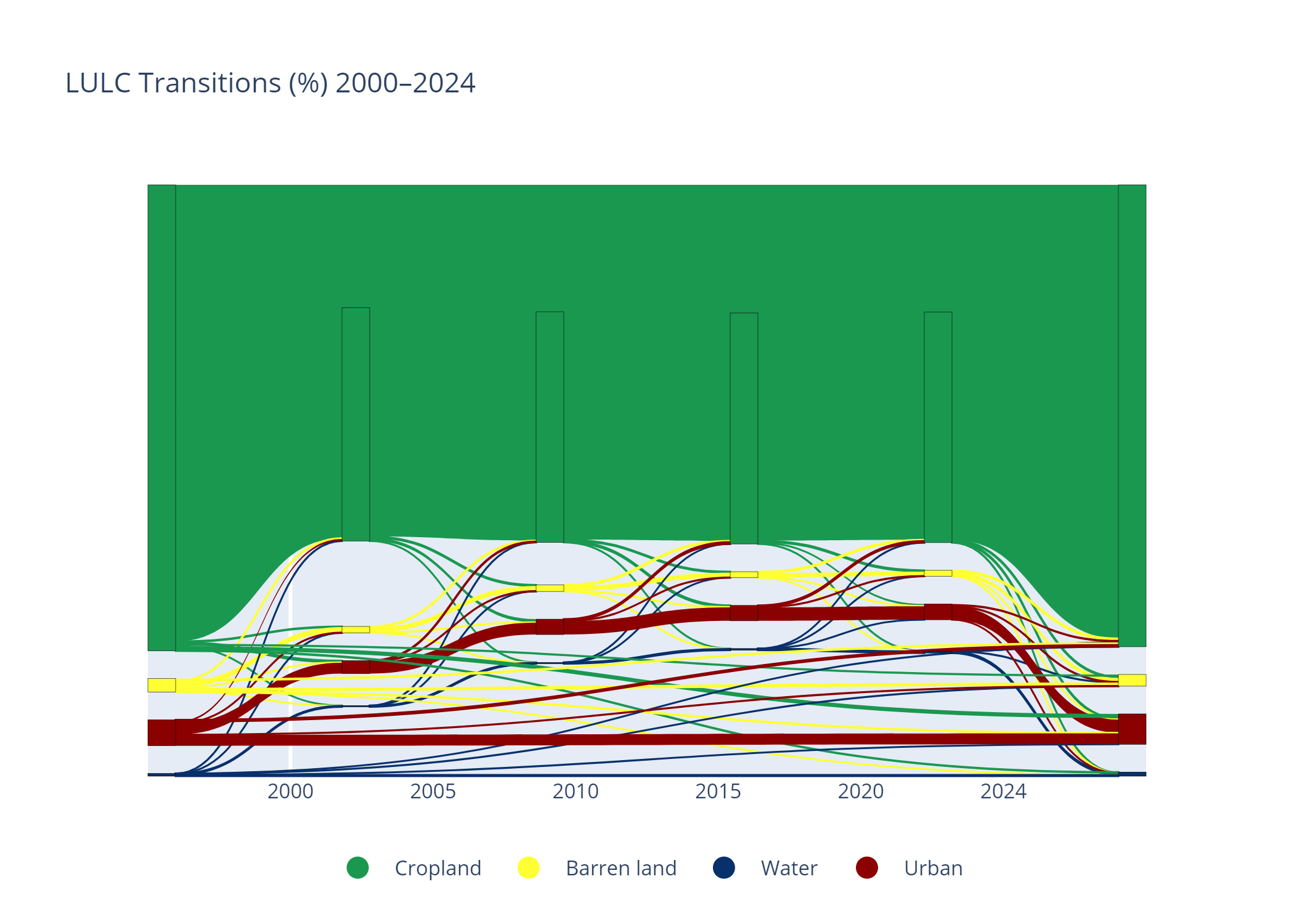
AbstractUrban growth in agriculturally productive districts creates a land-allocation challenge that is difficult to quantify without spatially consistent observations. This study investigates the magnitude, timing, and spatial expression of built-up expansion and associated cropland contraction in Sargodha District, Punjab, Pakistan, from 2000 to 2024. Six Landsat-based land-use/land-cover classifications (2000, 2005, 2010, 2015, 2020 and 2024), produced using Random Forest and post-classification comparison, were examined for four mapped classes: cropland, barren land, water and urban/built-up land. Built-up land increased from 290.22 to 391.92 km², a net gain of 101.70 km² (35.04% relative growth). Cropland declined from 5,319.22 to 5,239.88 km², a net reduction of 79.34 km². The greatest five-year urban gain occurred in 2010-2015 (39.69 km²), while spatial change maps identify urban-fringe expansion around Sargodha City and secondary centres. Barren land contracted by 22.19 km² and mapped water changed by only -0.17 km². Reported overall classification accuracies ranged from 89.00% to 95.95%, with Kappa values of 0.852-0.946. These results document a persistent agro-urban transition rather than a uniform loss of the district's agricultural landscape. The analysis provides a locally relevant baseline for monitoring peri-urban land conversion and prioritizing agricultural land protection. Interpretation remains conditional on the 30 m spatial resolution and the available time-specific validation information.
References
M. A. Wulder, J. G. Masek, W. B. Cohen, T. R. Loveland, and C. E. Woodcock, “Opening the archive: How free data has enabled the science and monitoring promise of Landsat,” Remote Sens. Environ., vol. 122, pp. 2–10, Jul. 2012, doi: 10.1016/J.RSE.2012.01.010.
K. C. Seto, B. Güneralp, and L. R. Hutyra, “Global forecasts of urban expansion to 2030 and direct impacts on biodiversity and carbon pools,” Proc. Natl. Acad. Sci., vol. 109, no. 40, pp. 16083–16088, Oct. 2012, doi: 10.1073/PNAS.1211658109.
R. L. B. Hooke, J. F. Martín-Duque, and J. Pedraza, “Land transformation by humans: A review,” GSA Today, vol. 22, no. 12, pp. 4–10, Dec. 2012, doi: 10.1130/GSAT151A.1.
T. V. Ha, M. Tuohy, M. Irwin, and P. V. Tuan, “Monitoring and mapping rural urbanization and land use changes using Landsat data in the northeast subtropical region of Vietnam,” Egypt. J. Remote Sens. Sp. Sci., vol. 23, no. 1, pp. 11–19, Apr. 2020, doi: 10.1016/J.EJRS.2018.07.001.
M. Z. Iqbal and M. J. Iqbal, “Land Use Detection Using Remote Sensing and GIS (A Case Study of Rawalpindi Division),” Am. J. Remote Sens. 2018, Vol. 6, Page 39, vol. 6, no. 1, pp. 39–51, Apr. 2018, doi: 10.11648/J.AJRS.20180601.17.
S. Hussain and S. Karuppannan, “Land use/land cover changes and their impact on land surface temperature using remote sensing technique in district Khanewal, Punjab Pakistan,” Geol. Ecol. Landscapes, 2021, doi: 10.1080/24749508.2021.1923272.
Z. Tahir, M. Haseeb, S. A. Mahmood, N. E. Hassan, M. M. Dogar, and S. Z. Hassan, “From Green to Grey: Assessing the Impact of Urbanization on Land Surface Temperature and Thermal Comfort in Multan City,” Earth Syst. Environ. 2025 92, vol. 9, no. 2, pp. 777–800, Feb. 2025, doi: 10.1007/S41748-025-00598-Y.
M. Hashim* et al., “Application of Geospatial Approaches for Evaluation of Urban Growth Pattern and Trend Prediction of Multan City, Pakistan,” Int. J. Innov. Sci. Technol., vol. 7, no. 9, pp. 108–120, 2025, Accessed: Aug. 31, 2026. [Online]. Available: https://ideas.repec.org/a/abq/ijist1/v7y2025i9p108-120.html
M. Sarwar, S. Mahmood, and W. Habib, “Assessing Urban Expansion and Land Cover Change in City District Lahore using Multi-Stage Satellite Data,” Int. J. Innov. Sci. Technol., vol. 7, no. 9, pp. 94–107, 2025, Accessed: Nov. 05, 2026. [Online]. Available: https://ideas.repec.org/a/abq/ijist1/v7y2025i9p94-107.html
A. A. Maitlo, N. H. Chandio, K. Hussain*, S. Mal, N. Noor, and M. WaseemNoonari, “Impact of Urbanization on Land Use and Land Cover: A Geospatial investigation of Taluka Khairpur (2000-2020),” Int. J. Innov. Sci. Technol., vol. 7, no. 9, pp. 77–84, 2025, Accessed: Nov. 05, 2026. [Online]. Available: https://ideas.repec.org/a/abq/ijist1/v7y2025i9p77-84.html
Z. Tahir et al., “Predicting land use and land cover changes for sustainable land management using CA-Markov modelling and GIS techniques,” Sci. Rep., vol. 15, no. 1, Dec. 2025, doi: 10.1038/S41598-025-87796-W.
G. N. Vivekananda, R. Swathi, and A. V. L. N. Sujith, “Multi-temporal image analysis for LULC classification and change detection,” Eur. J. Remote Sens., vol. 54, no. sup2, pp. 189–199, 2021, doi: 10.1080/22797254.2020.1771215.
C. Liping, S. Yujun, and S. Saeed, “Monitoring and predicting land use and land cover changes using remote sensing and GIS techniques—A case study of a hilly area, Jiangle, China,” PLoS One, vol. 13, no. 7, p. e0200493, Jul. 2018, doi: 10.1371/JOURNAL.PONE.0200493.
M. M. H. Seyam, M. R. Haque, and M. M. Rahman, “Identifying the land use land cover (LULC) changes using remote sensing and GIS approach: A case study at Bhaluka in Mymensingh, Bangladesh,” Case Stud. Chem. Environ. Eng., vol. 7, p. 100293, Jun. 2023, doi: 10.1016/J.CSCEE.2022.100293.
U. Bayarsaikhan, B. Boldgiv, K. R. Kim, K. A. Park, and D. Lee, “Change detection and classification of land cover at Hustai National Park in Mongolia,” Int. J. Appl. Earth Obs. Geoinf., vol. 11, no. 4, pp. 273–280, Aug. 2009, doi: 10.1016/J.JAG.2009.03.004.
Giles M. Foody, “Status of land cover classification accuracy assessment,” Remote Sens. Environ., vol. 80, no. 1, pp. 185–201, 2002, doi: https://doi.org/10.1016/S0034-4257(01)00295-4.
Y. Sreedhar, A. Nagaraju, and G. Murali Krishna, “An Appraisal of Land Use/Land Cover Change Scenario of Tummalapalle, Cuddapah Region, India—A Remote Sensing and GIS Perspective,” Adv. Remote Sens., vol. 05, no. 04, pp. 232–245, 2016, doi: 10.4236/ARS.2016.54019.
R. G. Congalton, “A review of assessing the accuracy of classifications of remotely sensed data,” Remote Sens. Environ., vol. 37, no. 1, pp. 35–46, Jul. 1991, doi: 10.1016/0034-4257(91)90048-B.
L. Breiman, “Random forests,” Mach. Learn., vol. 45, no. 1, pp. 5–32, Oct. 2001, doi: 10.1023/A:1010933404324.
R. Sonobe, Y. Yamaya, H. Tani, X. Wang, N. Kobayashi, and K. Mochizuki, “Crop classification from Sentinel-2-derived vegetation indices using ensemble learning,” J. Appl. Remote Sens., vol. 12, no. 02, pp. 1–16, May 2018, doi: 10.1117/1.JRS.12.026019.
H. Hoppe et al., “Transferability of Machine Learning Models for Crop Classification in Remote Sensing Imagery Using a New Test Methodology: A Study on Phenological, Temporal, and Spatial Influences,” Remote Sens. 2024, Vol. 16, Page 1493, vol. 16, no. 9, p. 1493, Apr. 2024, doi: 10.3390/RS16091493.
P. Olofsson, G. M.Foodu, H. Martin, V. S. Stephen, E. W. Curtis, and M. A. Wuldwe, Good practices for estimating area and assessing accuracy of land change, vol. 148. 2013.
M. Nasar-u-Minallah, D. Haase, S. Qureshi, S. Zia, and M. Fatima, “Ecological monitoring of urban thermal field variance index and determining the surface urban heat island effects in Lahore, Pakistan,” Environ. Monit. Assess. 2023 19510, vol. 195, no. 10, pp. 1212-, Sep. 2023, doi: 10.1007/S10661-023-11799-1.
Z. Hao et al., “Multitemporal Analysis of Urbanization-Driven Slope and Ecological Impact Using Machine-Learning and Remote Sensing Techniques,” IEEE J. Sel. Top. Appl. Earth Obs. Remote Sens., vol. 18, pp. 1876–1895, 2025, doi: 10.1109/JSTARS.2024.3509133.
M. Zhao et al., “Mapping urban dynamics (1992–2018) in Southeast Asia using consistent nighttime light data from DMSP and VIIRS,” Remote Sens. Environ., vol. 248, Oct. 2020, doi: 10.1016/J.RSE.2020.111980.
N. Gorelick, M. Hancher, M. Dixon, S. Ilyushchenko, D. Thau, and R. Moore, “Google Earth Engine: Planetary-scale geospatial analysis for everyone,” Remote Sens. Environ., vol. 202, pp. 18–27, Dec. 2017, doi: 10.1016/J.RSE.2017.06.031.
Y. Zha, J. Gao, and S. Ni, “Use of normalized difference built-up index in automatically mapping urban areas from TM imagery,” Int. J. Remote Sens., vol. 24, no. 3, pp. 583–594, Feb. 2003, doi: 10.1080/01431160304987.
H. Xu, “Modification of normalised difference water index (NDWI) to enhance open water features in remotely sensed imagery,” Int. J. Remote Sens., vol. 27, no. 14, pp. 3025–3033, Jul. 2006, doi: 10.1080/01431160600589179.
R. G. Pontius and M. Millones, “Death to Kappa: birth of quantity disagreement and allocation disagreement for accuracy assessment,” Int. J. Remote Sens., vol. 32, no. 15, pp. 4407–4429, 2011, doi: 10.1080/01431161.2011.552923.
P. K. Srivastava, D. Han, M. A. Rico-Ramirez, M. Bray, and T. Islam, “Selection of classification techniques for land use/land cover change investigation,” Adv. Sp. Res., vol. 50, no. 9, pp. 1250–1265, Nov. 2012, doi: 10.1016/J.ASR.2012.06.032.
M. Haseeb, Z. Tahir, S. A. Mahmood, S. Batool, and M. U. Farooq, “Spatial soil loss prediction impacted by long-term land use/land cover change: a case study of Swat District,” Environ. Monit. Assess. 2023 1961, vol. 196, no. 1, pp. 37-, Dec. 2023, doi: 10.1007/S10661-023-12200-X.
P. Olofsson, G. M. Foody, S. V. Stehman, and C. E. Woodcock, “Making better use of accuracy data in land change studies: Estimating accuracy and area and quantifying uncertainty using stratified estimation,” Remote Sens. Environ., vol. 129, pp. 122–131, Feb. 2013, doi: 10.1016/J.RSE.2012.10.031.
H. Zhang, M. Gao, and C. Ren, “Feature-Ensemble-Based Crop Mapping for Multi-Temporal Sentinel-2 Data Using Oversampling Algorithms and Gray Wolf Optimizer Support Vector Machine,” Remote Sens. 2022, Vol. 14, Page 5259, vol. 14, no. 20, p. 5259, Oct. 2022, doi: 10.3390/RS14205259.
R. Tufail, P. Tassinari, and D. Torreggiani, “Assessing feature extraction, selection, and classification combinations for crop mapping using Sentinel-2 time series: A case study in northern Italy,” Remote Sens. Appl. Soc. Environ., vol. 38, p. 101525, Apr. 2025, doi: 10.1016/J.RSASE.2025.101525.
I. Khan et al., “Impact assessment of land use change on surface temperature and agricultural productivity in Peshawar-Pakistan,” Environ. Sci. Pollut. Res., vol. 26, no. 32, pp. 33076–33085, Nov. 2019, doi: 10.1007/S11356-019-06448-5/METRICS.
C. S. Chanu, L. Elango, and G. R. Shankar, “A geospatial approach for assessing the relation between changing land use/land cover and environmental parameters including land surface temperature of Chennai metropolitan city, India,” Arab. J. Geosci. 2021 142, vol. 14, no. 2, pp. 132-, Jan. 2021, doi: 10.1007/S12517-020-06409-0.
R. Khan et al., “Monitoring land use land cover changes and its impacts on land surface temperature over Mardan and Charsadda Districts, Khyber Pakhtunkhwa (KP), Pakistan,” Environ. Monit. Assess. 2022 1946, vol. 194, no. 6, pp. 409-, May 2022, doi: 10.1007/S10661-022-10072-1.
Downloads
Published
How to Cite
Issue
Section
License
Copyright (c) 2026 50sea

This work is licensed under a Creative Commons Attribution 4.0 International License.