
Assessment and Validation of Land Surface Temperature (LST) Dynamics using Geo-spatial Techniques in Dera Ghazi Khan City, Pakistan
DOI:
https://doi.org/10.33411/ijist/2022040202Keywords:
Land Surface Temperature, Dynamics, Geo-spatial Techniques, Dera Ghazi Khan CityAbstract
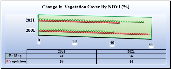
The integrated practice of remote-sensing and GIS techniques provides an active tool for assessment of spatial and temporal variability of land features. Based on literature, it can be suggested that various studies over the recent years have been carried out to explore the potential of geospatial techniques and were found highly efficient to understand the interdependency of landscape changes, land surface temperature changes (LST) and creation of Urban Heat Island (UHI) in major cities around globe. The current research was conducted in Dera Ghazi Khan, Punjab- Pakistan which is located at latitude 30.04587 N and longitude 70.64029 E. The Landsat 8 TIRS and OLI images were obtained free of cost from USGS e-data portal. These images have already been rectified to WGS-1984-UTM-Zone_43N. The meteorological data file (MTL) for Dera Ghazi Khan- contains the study was acquired from Pakistan Meteorological Department. As per results vegetation cover has been decreased up to 15 % from 2001 to 2021, which was directly affecting the land surface temperature. It has been observed that LST derived from the satellite was closely matched with ground climatic data; there was a mere temperature difference of 2°C to 3°C. It is concluded that LST was negatively correlated with vegetation cover of the area under study. It is suggested to implement road map as provided in Dera Ghazi Khan Master Plan-2021 in order to have a control on unplanned landscape changes, urban evolution and rapid population growth.
References
M. Stathopoulou and C. Cartalis, “Daytime urban heat islands from Landsat ETM+ and Corine land cover data: An application to major cities in Greece,” Sol. Energy, vol. 81, no. 3, pp. 358–368, Mar. 2007, doi: 10.1016/J.SOLENER.2006.06.014.
Q. Sun, J. Tan, and Y. Xu, “An ERDAS image processing method for retrieving LST and describing urban heat evolution: a case study in the Pearl River Delta Region in South China,” Environ. Earth Sci. 2009 595, vol. 59, no. 5, pp. 1047–1055, Feb. 2009, doi: 10.1007/S12665-009-0096-3.
L. Vlassova, F. Pérez-Cabello, M. R. Mimbrero, R. M. Llovería, and A. García-Martín, “Analysis of the relationship between land surface temperature and wildfire severity in a series of landsat images,” Remote Sens., vol. 6, no. 7, pp. 6136–6162, 2014, doi: 10.3390/rs6076136.
M. Bisquert, J. M. Sánchez, R. López-Urrea, and V. Caselles, “Estimating high resolution evapotranspiration from disaggregated thermal images,” Remote Sens. Environ., vol. 187, pp. 423–433, Dec. 2016, doi: 10.1016/J.RSE.2016.10.049.
R. He et al., “Evapotranspiration estimate over an almond orchard using Landsat satellite observations,” Remote Sens., vol. 9, no. 5, May 2017, doi: 10.3390/RS9050436.
S. Bonafoni and C. Keeratikasikorn, “Land surface temperature and urban density: Multiyear modeling and relationship analysis using modis and landsat data,” Remote Sens., vol. 10, no. 9, 2018, doi: 10.3390/rs10091471.
S. ÖZÜPEKÇE, “Use of Land Surface Temperature (Lst) Data in the Determination of High Areas of Forest Fire Risk in Erdemli District,” J. Int. Soc. Res., vol. 11, no. 57, pp. 227–232, 2018, doi: 10.17719/jisr.2018.2440.
B. N. Aryalekshmi, R. C. Biradar, and J. Mohammed Ahamed, “Thermal imaging techniques in agricultural applications,” Int. J. Innov. Technol. Explor. Eng., vol. 8, no. 12, pp. 2162–2168, 2019, doi: 10.35940/ijitee.L2949.1081219.
S. M. Z. Younis and J. Iqbal, “Estimation of soil moisture using multispectral and FTIR techniques,” Egypt. J. Remote Sens. Sp. Sci., vol. 18, no. 2, pp. 151–161, 2015, doi: 10.1016/j.ejrs.2015.10.001.
A. K. Holtgrave, M. Förster, F. Greifeneder, C. Notarnicola, and B. Kleinschmit, “Estimation of Soil Moisture in Vegetation-Covered Floodplains with Sentinel-1 SAR Data Using Support Vector Regression,” PFG - J. Photogramm. Remote Sens. Geoinf. Sci., vol. 86, no. 2, pp. 85–101, Apr. 2018, doi: 10.1007/S41064-018-0045-4.
S. K. Dash and J. C. R. Hunt, “Variability of climate change in India,” Curr. Sci., vol. 93, no. 6, pp. 782–788, 2007.
Y. K. Javed Mallick and B.D.Bharath, “Estimation of land surface temperature over Delhi using Landsat-7 ETM+,” J. Ind. Geophys. Union, vol. 12, no. 3, pp. 131–140, 2008, [Online]. Available: http://www.igu.in/12-3/5javed.pdf.
M. Maimaitiyiming et al., “Effects of green space spatial pattern on land surface temperature: Implications for sustainable urban planning and climate change adaptation,” ISPRS J. Photogramm. Remote Sens., vol. 89, no. February 2018, pp. 59–66, 2014, doi: 10.1016/j.isprsjprs.2013.12.010.
S. Pal and S. Ziaul, “Detection of land use and land cover change and land surface temperature in English Bazar urban centre,” Egypt. J. Remote Sens. Sp. Sci., vol. 20, no. 1, pp. 125–145, Jun. 2017, doi: 10.1016/J.EJRS.2016.11.003.
L. Rose Amirtham, M. David Devadas, L. A. Rose, and M. D. Devadas, “Analysis Of Land Surface Temperature And Land Use/Land Cover Types Using Remote Sensing Imagery-A Case In Chennai City, India. Architectural Design Process View Project Spaash Bricks View Project Analysis Of Land Surface Temperature And Land Use / Land Co,” No. May 2014, 2009, [Online]. Available: http://glcf.umiacs.umd.edu/index.shtml.
N. Mundhe, R. G. Jaybhaye, and N. N. Mundhe, “Impact of urbanization on land use/land covers change using Geo-spatial techniques,” Int. J. Geomatics Geosci., vol. 5, no. 1, pp. 50–60, 2014, [Online]. Available: https://www.researchgate.net/publication/281320790.
M. W. A. Halmy, P. E. Gessler, J. A. Hicke, and B. B. Salem, “Land use/land cover change detection and prediction in the north-western coastal desert of Egypt using Markov-CA,” Appl. Geogr., vol. 63, pp. 101–112, Sep. 2015, doi: 10.1016/J.APGEOG.2015.06.015.
V. N. Mishra and P. K. Rai, “A remote sensing aided multi-layer perceptron-Markov chain analysis for land use and land cover change prediction in Patna district (Bihar), India,” Arab. J. Geosci., vol. 9, no. 4, Apr. 2016, doi: 10.1007/S12517-015-2138-3.
E. Kalnay and M. Cai, “Impact of urbanization and land-use change on climate,” Nature, vol. 423, no. 6939, pp. 528–531, 2003, doi: 10.1038/nature01675.
A. Singh, S. Sharma, and B. Singh, “Effect of germination time and temperature on the functionality and protein solubility of sorghum flour,” J. Cereal Sci., vol. 76, pp. 131–139, Jul. 2017, doi: 10.1016/J.JCS.2017.06.003.
O. Hoegh-Guldberg et al., “Special Report on Global Warming of 1.5 °C - Chapter 3: Impacts of 1.5o C global warming on natural and human systems,” World Meteorol. Organ. Tech. Doc., pp. 175–311, 2018, [Online]. Available: http://report.ipcc.ch/sr15/pdf/sr15_chapter3.pdf.
A. Al Rakib, K. Akter, M. Rahman, … S. A.-1st I. S. R., and U. 2020, “Analyzing the pattern of land use land cover change and its impact on land surface temperature: a remote sensing approach in mymensingh, Bangladesh,” Academia.Edu, no. December, 2020, [Online]. Available: https://www.academia.edu/download/65116756/NS_09.pdf.
B. N. Aryalekshmi, M. J. Ahamed, R. C. Biradar, and K. Chandrasekar, “Land surface temperature estimation of mandya district using LANDSAT-8 data,” J. Appl. Sci. Eng., vol. 23, no. 4, pp. 583–591, 2020, doi: 10.6180/jase.202012_23(4).0002.
E. Mandelas, “A fuzzy cellular automata based shell for modeling urban growth–a pilot application in Mesogia area,” 10th Agil. Int. …, no. 2004, pp. 1–9, 2007, [Online]. Available: http://141.30.100.200/Conference_Paper/CDs/agile_2007/PROC/PDF/17_PDF.pdf.
E. Kannan, G. Balamurugan, and S. Narayanan, “Spatial economic analysis of agricultural land use changes: a case of peri-urban Bangalore, India,” https://doi.org/10.1080/13547860.2020.1717285, vol. 26, no. 1, pp. 34–50, 2020, doi: 10.1080/13547860.2020.1717285.
Published
How to Cite
Issue
Section
License
Copyright (c) 2022 International Journal of Innovations in Science & Technology

This work is licensed under a Creative Commons Attribution 4.0 International License.


