
Variability of Geomorphological Characteristics and the Altered Hydrological Regime of the Upper Indus Basin, Pakistan
Keywords:
Upper Indus Basin, Hydrological process, Drainage Density, Erosion, Geomorphological charactersAbstract
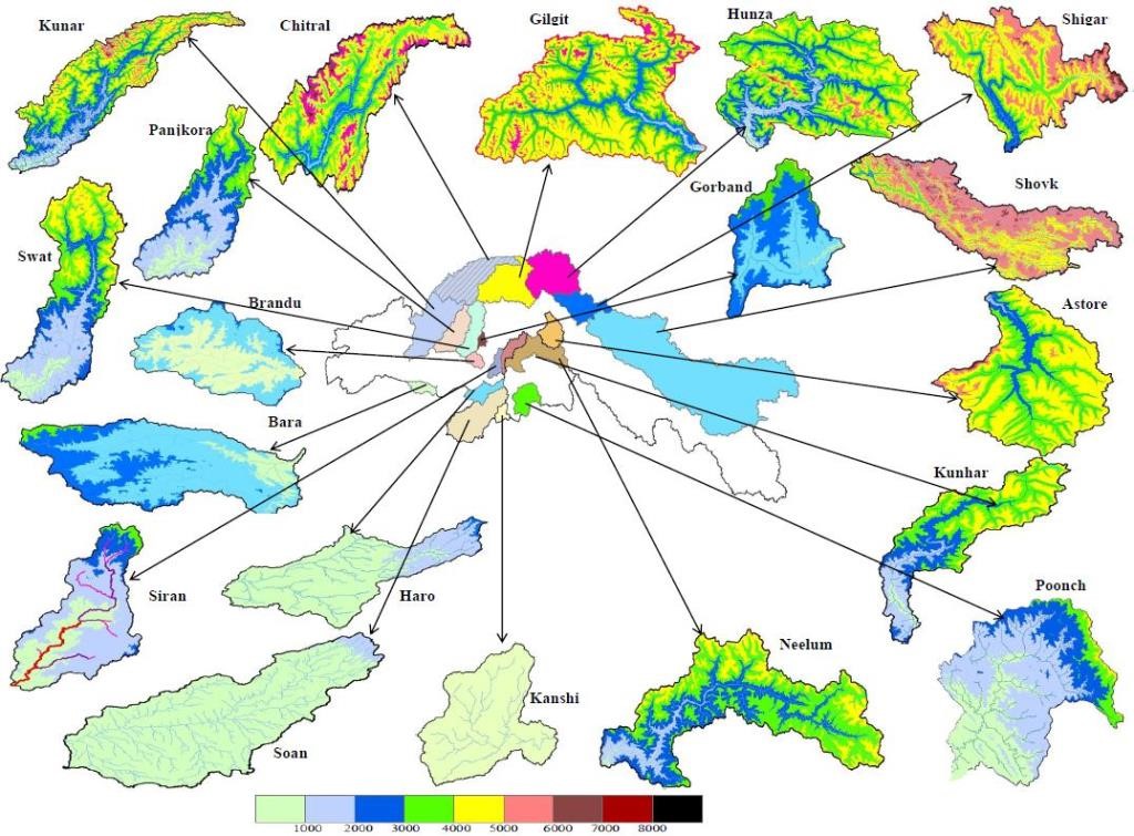
The administration of watersheds holds significant relevance in the field of water resources engineering and management. The main objective of this research is to assess the geomorphological attributes of the Upper Indus Basin (UIB) in Pakistan, with a particular emphasis on its hydrological phenomena. The demarcation of the boundaries of the 21 sub-basins within the UIB was achieved by employing ArcGIS software. The findings indicate that the subbasins demonstrate a range of drainage patterns, varying from sub-dendritic to dendritic. This suggests that there is a consistent texture and absence of structural influence within the subbasins. The research identified a range of stream orders, extending from 3.76 to 365.73 km, indicating a diversity in bifurcation ratios that spans from 3.00 to 5.40. The findings of this investigation suggest the presence of geologic formations that offer favorable conditions. The total length of streams and the number of stream segments demonstrate an upward trend in first-order streams, whereas they decline as the stream order advances. The Drainage Density (DD) of all sub-watersheds has a variation ranging from 0.170 to 0.231 km-1, indicating the presence of regions characterized by materials with notable resistance and porosity. The observed low drainage intensity in these watersheds suggested that the capacity to remove surface runoff is insufficient, rendering them susceptible to the occurrence of flooding, gully erosion, and landslides. Greater infiltration capacity and less runoff are correlated with higher elongation ratios. The findings derived from our study are intended to provide a significant contribution to the development of a sustainable water management strategy for the UIB in the upcoming years. The main focus of this work is to analyze the geomorphological characteristics of mountainous watersheds located in the UIB of Pakistan and assess their influence on hydrologic processes.
References
K. J. Gregory, “Drainage networks and climate. Chapter 10 in Geomorphology and Climate (E, Derbyshire ed.).,” London John Wiley, 1976.
P. H. Pinchmel, “Densities de drainage et densities et densities des Valles.,” Tijol ker Ned Ard-Kun. Genoots, pp. 373-376., 1957.
R. P. C. Morgan, “The role of climate in the denudation system: A case study from west Malaysia. Chapter II in Geomorphology and Climate (Derbyshire, E ed.).,” London John Wiley Sons, 1976.
S. DE Chorley RJ, Schumm SA, “Geomorphology. Methuen, London. GIS techniques.,” Int. J. Eng. Sci. Technol., vol. 2, no. 12, pp. 7763–7770, 1984.
S. S, “Quantitative analysis of watershed geomorphology using remote sensing techniques.,” Ann Arid Zo., vol. 34, no. 4, pp. 243–251, 1995.
P. E. Potter, “ A Quantitative Geomorphic Study of Drainage Basin Characteristics in the Clinch Mountain Area, Virginia and Tennessee. V. C. Miller ,” https://doi.org/10.1086/626413, vol. 65, no. 1, pp. 112–113, Jan. 1957, doi: 10.1086/626413.
“Faniran, A. (1968) The Index of Drainage Intensity—A Provisional New Drainage Factor. Australian Journal of Science, 31, 328-330. - References - Scientific Research Publishing.” https://www.scirp.org/(S(351jmbntvnsjt1aadkposzje))/reference/ReferencesPapers.aspx?ReferenceID=1845498 (accessed Oct. 10, 2023).
“Schumm, S.A. (1956) Evolution of Drainage Systems and Slopes in Badlands at Perth Amboy, New Jersey. Geological Society of America Bulletin, 67, 597-646. - References - Scientific Research Publishing.” https://www.scirp.org/(S(351jmbntvnsjt1aadkposzje))/reference/ReferencesPapers.aspx?ReferenceID=1768382 (accessed Oct. 10, 2023).
R. Chorley, “Horton, R.E. 1945: Erosional development of streams and their drainage basins: Hydrophysical approach to quantitative morphology. Bulletin of the Geological Society of America 56, 2 75-370,” Prog. Phys. Geogr., vol. 19, no. 4, pp. 533–554, Dec. 1995, doi: 10.1177/030913339501900406/ASSET/030913339501900406.FP.PNG_V03.
“Melton, M. (1957) An Analysis of the Relations Among Elements of Climate, Surface Properties and Geomorphology. Department of Geology, Columbia University, Technical Report, 11, Project NR 389-042. Office of Navy Research, New York. - References - Scientific Research Publishing.” https://www.scirp.org/(S(i43dyn45teexjx455qlt3d2q))/reference/ReferencesPapers.aspx?ReferenceID=2029733 (accessed Oct. 10, 2023).
W. Liu and C. Shi, “Analysis of University Science Research Capability Elements and Evaluation Based on BP Neural Network,” J. Serv. Sci. Manag., vol. 01, no. 03, pp. 266–271, 2008, doi: 10.4236/JSSM.2008.13030.
B. Víg et al., “Morphometric analysis of low mountains for mapping flash flood susceptibility in headwaters,” Nat. Hazards, vol. 114, no. 3, pp. 3235–3254, Dec. 2022, doi: 10.1007/S11069-022-05513-6/FIGURES/11.
A. Al-Hurban, F. Al-Ruwaih, and A. Al-Dughairi, “Quantitative Geomorphological and Hydromorphometric Analysis of Drainage Basins of As Sabriyah (Kuwait) Using GIS Techniques,” J. Geogr. Inf. Syst., vol. 13, no. 02, pp. 166–193, 2021, doi: 10.4236/JGIS.2021.132010.
N. Hadadin, Z. Tarawneh, K. Shatanawi, Q. Banihani, and M. R. Hamdi, “Hydrological Analysis for Floodplain Hazard of Jeddah’s Drainage Basin, Saudi Arabia,” Arab. J. Sci. Eng., vol. 38, no. 12, pp. 3275–3287, Oct. 2013, doi: 10.1007/S13369-013-0812-X/METRICS.
C. I. Ikhile, “Geomorphology and Hydrology of the Benin Region, Edo State, Nigeria,” Int. J. Geosci., vol. 07, no. 02, pp. 144–157, 2016, doi: 10.4236/IJG.2016.72012.
A. N. Strahler, “Quantitative Gemorphology of Drainage Basin and chanel Networks Chapter 4 in Tech. Mem. 66/5.,” Handb. Appl. Hydrol. (e V. T. Chow (ed)). New York MC Graw Hill., 1964.
R. E. Horton, “Erosional Development of Streams and their Drainage Basins, Bulletin of the Geological Society of America,” vol. 56, pp. 275–370, 1945.
J. Krishnamurthy, G. Srinivas, V. Jayaraman, and M. Chandrasekhar, “Influence of rock types and structures in the development of drainage networks in typical hardrock terrain,” 1996.
O. YILDIZ, “An investigation of the effect of drainage density on hydrologic response,” Turkish J. Eng. Environ. Sci., vol. 28, no. 2, pp. 85–94, 2004, Accessed: Oct. 10, 2023. [Online]. Available: http://search/yayin/detay/1268
“Singh, S. (1992) Quantitative Geomorphology of the Drainage Basin. In Chouhan T.S., and Joshi, K.N., Eds., Readings on Remote Sensing Applications, Scientific Publishers, Jodhpur. - References - Scientific Research Publishing.” https://www.scirp.org/(S(lz5mqp453edsnp55rrgjct55.))/reference/referencespapers.aspx?referenceid=2163426 (accessed Oct. 10, 2023).
R. V. Ruhe, “Topographic discontinuities of the Des Moines lobe [Iowa-Minnesota],” Am. J. Sci., vol. 250, no. 1, pp. 46–56, Jan. 1952, doi: 10.2475/AJS.250.1.46.
R. E. Horton, “Drainage-basin characteristics,” Eos, Trans. Am. Geophys. Union, vol. 13, no. 1, pp. 350–361, Jun. 1932, doi: 10.1029/TR013I001P00350.
P. K. Rai, K. Mohan, S. Mishra, A. Ahmad, and V. N. Mishra, “A GIS-based approach in drainage morphometric analysis of Kanhar River Basin, India,” Appl. Water Sci., vol. 7, no. 1, pp. 217–232, Mar. 2017, doi: 10.1007/S13201-014-0238-Y/FIGURES/7.
I. RodrÍguez-Iturbe and L. A. Escobar, “The dependence of drainage density on climate and geomorphology,” Hydrol. Sci. J., vol. 27, no. 2, pp. 129–137, 1982, doi: 10.1080/02626668209491095.
Z. R. Ansari, L. A. K. Rao, and A. Yusuf, “Gis based morphometric analysis of yamuna drainage network in parts of fatehabad area of agra district, Uttar Pradesh,” J. Geol. Soc. India, vol. 79, no. 5, pp. 505–514, May 2012, doi: 10.1007/S12594-012-0075-2/METRICS.
K. P. Berger and D. Entekhabi, “Basin hydrologic response relations to distributed physiographic descriptors and climate,” J. Hydrol., vol. 247, no. 3–4, pp. 169–182, Jul. 2001, doi: 10.1016/S0022-1694(01)00383-3.
R. A. Dar, R. Chandra, and S. A. Romshoo, “Morphotectonic and lithostratigraphic analysis of intermontane Karewa Basin of Kashmir Himalayas, India,” J. Mt. Sci., vol. 10, no. 1, pp. 1–15, Feb. 2013, doi: 10.1007/S11629-013-2494-Y/METRICS.
D. Sindhu, Sadashivappa, A. S. Ravikumar, and B. L. Shivakumar, “Quantitative Analysis of Catchment Using Remote Sensing and Geographic Information System,” Aquat. Procedia, vol. 4, pp. 1421–1428, Jan. 2015, doi: 10.1016/J.AQPRO.2015.02.184.
Published
How to Cite
Issue
Section
License
Copyright (c) 2023 50SEA

This work is licensed under a Creative Commons Attribution 4.0 International License.


