Exploring the Dynamics of Urban Sprawl Using GIS & RS Techniques and By Modeling Using Ca-Markov Model in District Peshawar
Keywords:
Urban Sprawl, LULC, CA-Markov Model, Land Change Modelling.Abstract
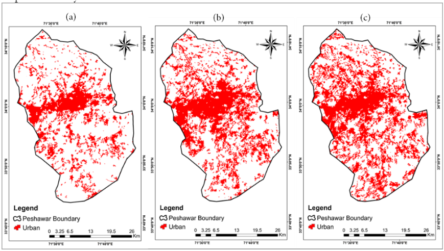
Urban Sprawl is described by the unplanned and uneven growth pattern in the built-up areas, determined by several processes and leading to ineffective resource utilization. Pakistan, a developing country, is struggling with extreme population growth and currently ranks fifth globally in terms of population size. Peshawar, the provincial capital of Khyber Pakhtunkhwa, has undergone significant urbanization in recent decades for various reasons, necessitating a comprehensive analysis to inform urban planning. In the present work the urban sprawl of the Peshawar district has been studied from 2010-2020, and future predictions for the year 2030 are evaluated. This research uniquely utilizes the CA-Markov model to predict urban sprawl for the year 2030, a method not previously applied in the earlier studies in the study area. This research is carried out to examine the land use pattern, to find out the urban sprawl from 2010 to 2020 using remotely sensed satellite data for three periods (2010, 2015 and 2020). The object-Based Image Analysis (OBIA) approach was used to examine the land use patterns. The LULC prediction till 2030 is done by using the CA-Markov Model in a GIS environment. The pattern of development of urban sprawl in Peshawar is typical of most Pakistani major cities, where ribbon sprawl is common along major roads, while leapfrog sprawl is dominant in the city’s outer edge. The LULC changes derived from the OBIA method show that urban area expanded from 23% to 39% of the whole area, while agriculture decreased from 44% to 35% over ten years. To grip land use changes better, the paper proposes a method for the simulation of spatial patterns. The simulating method can be divided into two parts: one is a quantitative forecast by using the Markov model and the other is simulating the spatial pattern changes by using the CA model. The above two models construct the simulative model of the spatial pattern of land use. CA–Markov is used to simulate the spatial pattern of land use in Peshawar for 2030, which indicates that the urban land will reach a total of 44% consuming areas from Barren Land and Vegetation land.
References
Cobbinah, P. B., & Darkwah, R. M. (2016). African Urbanism: The Geography of Urban Greenery. Urban Forum, 27(2), 149–165. https://doi.org/10.1007/s12132-016-9274-z
Mosammam, H. M., J. T. Nia, H. Khani, A. Teymouri, and M. Kazemi. 2017. “Monitoring Land Use Change and Measuring Urban Sprawl Based on Its Spatial Forms: The Case of Qom City.” Egyptian Journal of Remote Sensing and Space Science 20 (1): 103–116. doi:10.1016/j.ejrs.2016.08.002.
Xu, G., T. Dong, P. Brandful, L. Jiao, N. S. Sumari, B. Chai, and Y. Liu. 2019a. “Urban Expansion and Form Changes across African Cities with a Global Outlook: Spatiotemporal Analysis of Urban Land Densities.” Journal of Cleaner Production 224: 802–810. doi:10.1016/j.jclepro.2019.03.276.
Fouberg, E. H., A. B. Murphy, and H. J. DeBlij. 2012. Human Geography: People, Place, and Culture. 10th ed. John Wiley & Sons Inc. ISBN-10: 1118514653.
Bhatta, B., Saraswati, S., & Bandyopadhyay, D. (2010). Urban sprawl measurement from remote sensing data. Applied Geography, 30(4), 731–740. https://doi.org/10.1016/j.apgeog.2010.02.002
Ali, J. M., Marsh, S. H., & Smith, M. J. (2017). A comparison between London and Baghdad surface urban heat islands and possible engineering mitigation solutions. Sustainable Cities and Society, 29, 159-168.
Herold, M., Goldstein, N. C., & Clarke, K. C. (2003). The spatiotemporal form of urban growth: measurement, analysis and modeling. Remote Sensing of Environment, 86(3), 286–302. https://doi.org/10.1016/s0034-4257(03)00075-0
Liu, X., & Lathrop, R. G. (2002). Urban change detection based on an artificial neural network. International Journal of Remote Sensing, 23(12), 2513–2518. https://doi.org/10.1080/01431160110097240
Goetz, A., (2013). Suburban sprawl or urban centers: Tensions and contradictions of smart growth approaches in Denver, Colorado. Urban Stud., 50: 2178-2195.
Fu, Y., Lu, X., Zhao, Y., Zeng, X., & Xia, L. (2013). Assessment impacts of weather and land use/land cover (LULC) change on urban vegetation net primary productivity (NPP): A case study in Guangzhou, China. Remote Sensing, 5(8), 4125-4144.
Ligate, E. J., Chen, C., & Wu, C. (2018). Evaluation of tropical coastal land cover and land use changes and their impacts on ecosystem service values. Ecosystem health and sustainability, 4(8), 188-204.
Lu, L., Guo, H., Corbane, C., & Li, Q. (2019). Urban sprawl in provincial capital cities in China: Evidence from multi-temporal urban land products using Landsat data. Sci. Bull., 64, 955–957.
Hashem, N., and Balakrishnan, P. (2015) Change analysis of land use/land cover and modeling urban growth in Greater Doha, Qatar. Ann. GIS 2015, 21, 233–247.
Nath, B., Wang, Z., Ge, Y., Islam, K., Singh, R. P., & Niu, Z. (2020). Land use and land cover change modeling and future Potential landscape risk assessment using the Markov-CA model and analytical hierarchy process. ISPRS International Journal of Geo-information, 9(2), 134. https://doi.org/10.3390/ijgi9020134
Keshtkar, H., & Voigt, W. (2016). Potential impacts of climate and landscape fragmentation changes on plant distributions: Coupling multi-temporal satellite imagery with GIS-based cellular automata model. Ecological Informatics, 32, 145–155. https://doi.org/10.1016/j.ecoinf.2016.02.002
Rimal, B., Zhang, L., Keshtkar, H., Haack, B., Rijal, S., & Zhang, P. (2018). Land Use/Land Cover dynamics and modeling of urban land expansion by the integration of Cellular Automata and Markov Chain. ISPRS International Journal of Geo-information, 7(4), 154. https://doi.org/10.3390/ijgi7040154
Raziq, A., Xu, A., Li Y., Zhao, Q. (2016) Monitoring of Land Use/Land Cover Changes and Urban Sprawl in Peshawar City in Khyber Pakhtunkhwa: An Application of Geo-Information Techniques Using of Multi-Temporal Satellite Data. J Remote Sensing & GIS 5: 174. doi:10.4172/2469-4134.1000174
Mehmood, R., Mehmood, S. A., Butt, M. A., Younas, I. and Adrees, M. (2016) Spatiotemporal analysis of urban sprawl and its contributions to climate and environment of Peshawar using remote sensing and GIS techniques. Journal of Geographic Information System, 08(02), 137–148. https://doi.org/10.4236/jgis.2016.82013

Downloads
Published
How to Cite
Issue
Section
License
Copyright (c) 2024 50sea

This work is licensed under a Creative Commons Attribution 4.0 International License.


