
Integrating Multiple Datasets in Google Earth Engine for Advanced Hydrological Modeling Using the Soil Conservation Service Curve Number Method
Keywords:
SCS CN Method, Hydrological Modeling, Runoff Estimation, CHIRPS, Gpm, Trmm, Google Earth Engine, Cloud ComputingAbstract
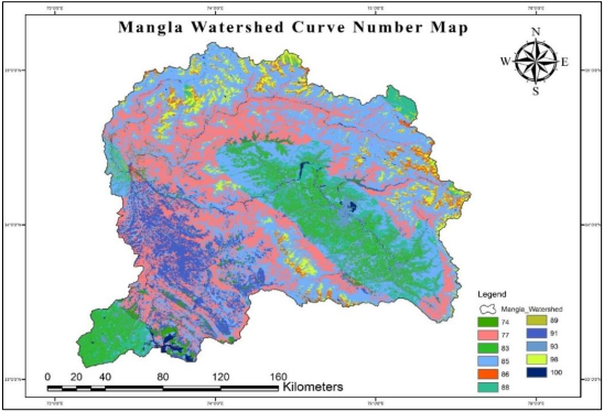
This research explores the feasibility of using cloud computing and open data sources for hydrological modeling, specifically leveraging Google Earth Engine (GEE) and the Soil Conservation Service Curve Number (SCS CN) method to estimate runoff. The SCS CN approach is commonly applied in simulating rainfall-runoff processes and is effective for estimating water inflow into rivers, lakes, and streams. Google Earth Engine provides a range of functionalities, including algorithms for rapid data manipulation and visualization, and access to extensive global remote sensing and geographic information system (GIS) datasets. The study introduces an algorithm developed in GEE to analyze precipitation data and generate antecedent moisture condition (AMC) maps. This algorithm integrates MODIS land use/land cover (LULC) data with USDA soil texture data to classify hydrological soil groups. Runoff estimation utilizes three datasets: CHIRPS, GPM, and TRMM. A thorough analysis of the rainfall-runoff relationship in the Mangla watershed from 2005 to 2015 is conducted. The study quantifies runoff estimates from each dataset and performs comparative analysis to validate the accuracy and reliability of the hydrological modeling. Over the ten-year period (2005-2015), significant fluctuations in average rainfall and runoff levels are observed, with notable seasonal patterns. The highest average precipitation of 1412.194 mm occurred in 2015, resulting in an average runoff of 215.021 mm. Conversely, 2009 recorded the lowest average precipitation of 672.808 mm and an average runoff of 78.476 mm. The accuracy of the modeled runoff observations is validated using meteorological data from the Pakistan Meteorological Department (PMD), Water and Power Development Authority (WAPDA), and Climate Forecast System Reanalysis (CFSR). In 2008, 2009, and 2010, CHIRPS consistently demonstrated better accuracy compared to GPM and TRMM, with accuracies of 90%, 79%, and 86% respectively. Additionally, a sensitivity analysis of the SCS CN model parameters reveals the effects of initial abstraction and Curve Number values on runoff estimation. In conclusion, this research enhances the understanding of hydrological processes in monsoon-affected regions and offers valuable recommendations for implementing sustainable water resource management practices.
References
W. Shi and N. Wang, “An Improved SCS-CN Method Incorporating Slope, Soil Moisture, and Storm Duration Factors for Runoff Prediction,” Water 2020, Vol. 12, Page 1335, vol. 12, no. 5, p. 1335, May 2020, doi: 10.3390/W12051335.
N. Gedney, P. M. Cox, R. A. Betts, O. Boucher, C. Huntingford, and P. A. Stott, “Detection of a direct carbon dioxide effect in continental river runoff records,” Nat. 2006 4397078, vol. 439, no. 7078, pp. 835–838, Feb. 2006, doi: 10.1038/nature04504.
H. Chu, J. Wei, J. Qiu, Q. Li, and G. Wang, “Identification of the impact of climate change and human activities on rainfall-runoff relationship variation in the Three-River Headwaters region,” Ecol. Indic., vol. 106, p. 105516, Nov. 2019, doi: 10.1016/J.ECOLIND.2019.105516.
Y. Xu, S. Wang, X. Bai, D. Shu, and Y. Tian, “Runoff response to climate change and human activities in a typical karst watershed, SW China,” PLoS One, vol. 13, no. 3, p. e0193073, Mar. 2018, doi: 10.1371/JOURNAL.PONE.0193073.
N. Akhtar, M. I. Syakir Ishak, S. A. Bhawani, and K. Umar, “Various Natural and Anthropogenic Factors Responsible for Water Quality Degradation: A Review,” Water 2021, Vol. 13, Page 2660, vol. 13, no. 19, p. 2660, Sep. 2021, doi: 10.3390/W13192660.
S. K. Mishra and V. P. Singh, “Validity and extension of the SCS-CN method for computing infiltration and rainfall-excess rates,” Hydrol. Process., vol. 18, no. 17, pp. 3323–3345, Dec. 2004, doi: 10.1002/HYP.1223.
M. Lal et al., “Evaluation de la méthode du numéro de courbe du Service de la Conservation des Sols à partir de données provenant de parcelles agricoles,” Hydrogeol. J., vol. 25, no. 1, pp. 151–167, Feb. 2017, doi: 10.1007/S10040-016-1460-5/METRICS.
S. Verma, R. K. Verma, S. K. Mishra, A. Singh, and G. K. Jayaraj, “A revisit of NRCS-CN inspired models coupled with RS and GIS for runoff estimation,” Hydrol. Sci. J., vol. 62, no. 12, pp. 1891–1930, Sep. 2017, doi: 10.1080/02626667.2017.1334166.
L. H. Sujud and H. H. Jaafar, “A global dynamic runoff application and dataset based on the assimilation of GPM, SMAP, and GCN250 curve number datasets,” Sci. Data 2022 91, vol. 9, no. 1, pp. 1–11, Nov. 2022, doi: 10.1038/s41597-022-01834-0.
A. W. Dhawale, “Runoff Estimation for Darewadi Watershed using RS and GIS 47”, [Online]. Available: https://www.ijrte.org/wp-content/uploads/papers/v1i6/F0413021613.pdf
“Estimation of Runoff by using SCS Curve Number Method and Arc GIS.” Accessed: Jun. 16, 2024. [Online]. Available: https://www.researchgate.net/publication/290947015_Estimation_of_Runoff_by_using_SCS_Curve_Number_Method_and_Arc_GIS
W. Shi and N. Wang, “Improved SMA-based SCS-CN method incorporating storm duration for runoff prediction on the Loess Plateau, China,” Hydrol. Res., vol. 51, no. 3, pp. 443–455, Jun. 2020, doi: 10.2166/NH.2020.140.
P. K. Singh, S. K. Mishra, R. Berndtsson, M. K. Jain, and R. P. Pandey, “Development of a Modified SMA Based MSCS-CN Model for Runoff Estimation,” Water Resour. Manag., vol. 29, no. 11, pp. 4111–4127, Sep. 2015, doi: 10.1007/S11269-015-1048-1/METRICS.
H. Haider et al., “Appraisal of Climate Change and Its Impact on Water Resources of Pakistan: A Case Study of Mangla Watershed,” Atmos. 2020, Vol. 11, Page 1071, vol. 11, no. 10, p. 1071, Oct. 2020, doi: 10.3390/ATMOS11101071.
U. W. Humphries et al., “Runoff Estimation Using Advanced Soft Computing Techniques: A Case Study of Mangla Watershed Pakistan,” Water 2022, Vol. 14, Page 3286, vol. 14, no. 20, p. 3286, Oct. 2022, doi: 10.3390/W14203286.
M. Yaseen, G. Nabi, M. Latif, and C. Author, “Assessment of Climate Change at Spatiao-Temporal Scales and its Impact on Stream Flows in Mangla Watershed,” Pakistan J. Eng. Appl. Sci., vol. 15, pp. 17–36, 2014, Accessed: Jun. 16, 2024. [Online]. Available: https://journal.uet.edu.pk/ojs_old/index.php/pjeas/article/view/91
M. J. Butt, R. Mahmood, and A. Waqas, “Sediments deposition due to soil erosion in the watershed region of Mangla Dam,” Environ. Monit. Assess., vol. 181, no. 1–4, pp. 419–429, Oct. 2011, doi: 10.1007/S10661-010-1838-0/METRICS.
M. Azmat, F. Laio, and D. Poggi, “Estimation of water resources availability and mini-hydro productivity in high-altitude scarcely-gauged watershed,” Water Resour. Manag., vol. 29, no. 14, pp. 5037–5054, Nov. 2015, doi: 10.1007/S11269-015-1102-Z/METRICS.
K. M. Kent, “NATIONAL ENGINEERING HANDBOOK SECTION 4 HYDROLOGY CHAPTER 15. TRAVEL TIME, TIME OF CONCENTRATION. AND LAG”.
H. Mckeever, V., Owen, W., Rallison, R., Engineers, “NATIONAL ENGINEERING HANDBOOK SECTION 4”.
H. Sutradhar and W.-C. Liu, “Surface Runoff Estimation Using SCS-CN Method in Siddheswari River Basin, Eastern India,” J. Geogr. Environ. Earth Sci. Int., vol. 17, no. 2, pp. 1–9, Sep. 2018, doi: 10.9734/JGEESI/2018/44076.
S. Satheeshkumar, S. Venkateswaran, and R. Kannan, “Rainfall–runoff estimation using SCS–CN and GIS approach in the Pappiredipatti watershed of the Vaniyar sub basin, South India,” Model. Earth Syst. Environ. 2017 31, vol. 3, no. 1, pp. 1–8, Feb. 2017, doi: 10.1007/S40808-017-0301-4.
N. N. . Vannasy M., “Estimating Direct Runoff from Storm Rainfall Using NRCS Runoff Method and GIS Mapping in Vientiane City, Laos”, [Online]. Available: http://article.nadiapub.com/IJGDC/vol9_no4/23.pdf
C. Strapazan, I. A. Irimuș, G. Șerban, T. C. Man, and L. Sassebes, “Determination of Runoff Curve Numbers for the Growing Season Based on the Rainfall–Runoff Relationship from Small Watersheds in the Middle Mountainous Area of Romania,” Water 2023, Vol. 15, Page 1452, vol. 15, no. 8, p. 1452, Apr. 2023, doi: 10.3390/W15081452.
S. K. Mishra, M. K. Jain, P. Suresh Babu, K. Venugopal, and S. Kaliappan, “Comparison of AMC-dependent CN-conversion formulae,” Water Resour. Manag., vol. 22, no. 10, pp. 1409–1420, Jan. 2008, doi: 10.1007/S11269-007-9233-5/METRICS.
S. K. Mishra, R. P. Pandey, M. K. Jain, and V. P. Singh, “A rain duration and modified AMC-dependent SCS-CN procedure for long duration rainfall-runoff events,” Water Resour. Manag., vol. 22, no. 7, pp. 861–876, Jul. 2008, doi: 10.1007/S11269-007-9196-6/METRICS.
R. Amutha and P. Porchelvan, “Estimation of surface runoff in malattar sub-watershed using SCS-cn method,” J. Indian Soc. Remote Sens., vol. 37, no. 2, pp. 291–304, Oct. 2009, doi: 10.1007/S12524-009-0017-7/METRICS.
H. Blanco-Canqui and R. Lal, “Soil Resilience and Conservation,” Princ. Soil Conserv. Manag., pp. 425–447, 2010, doi: 10.1007/978-1-4020-8709-7_16.
E. Walker and V. Venturini, “Land surface evapotranspiration estimation combining soil texture information and global reanalysis datasets in Google Earth Engine,” Remote Sens. Lett., vol. 10, no. 10, pp. 929–938, Oct. 2019, doi: 10.1080/2150704X.2019.1633487.
M. Shahid et al., “Assessing the potential and hydrological usefulness of the CHIRPS precipitation dataset over a complex topography in Pakistan,” Hydrol. Sci. J., vol. 66, no. 11, pp. 1664–1684, Aug. 2021, doi: 10.1080/02626667.2021.1957476.
F. J. Tapiador et al., “Global precipitation measurement: Methods, datasets and applications,” Atmos. Res., vol. 104–105, pp. 70–97, Feb. 2012, doi: 10.1016/J.ATMOSRES.2011.10.021.
G. J. Huffman et al., “Integrated Multi-satellite Retrievals for the Global Precipitation Measurement (GPM) Mission (IMERG),” Adv. Glob. Chang. Res., vol. 67, pp. 343–353, 2020, doi: 10.1007/978-3-030-24568-9_19.
C. Kummerow et al., “The Status of the Tropical Rainfall Measuring Mission (TRMM) after Two Years in Orbit,” J. Appl. Meteorol. Climatol., vol. 39, no. 12, pp. 1965–1982, Dec. 2000, doi: 10.1175/1520-0450(2001)040.
R. Jain, S., Jaiswal, R. K., Lohani, A. K., Galkate, “Development of cloud-based rainfall-run-off model using Google Earth Engine,” 2021, [Online]. Available: https://www.currentscience.ac.in/Volumes/121/11/1433.pdf
Z. Shen et al., “Recent global performance of the Climate Hazards group Infrared Precipitation (CHIRP) with Stations (CHIRPS),” J. Hydrol., vol. 591, p. 125284, Dec. 2020, doi: 10.1016/J.JHYDROL.2020.125284.
J. S. Theon, “The tropical rainfall measuring mission (TRMM),” Adv. Sp. Res., vol. 14, no. 3, pp. 159–165, Mar. 1994, doi: 10.1016/0273-1177(94)90210-0.
M. Babur, M. S. Babel, S. Shrestha, A. Kawasaki, and N. K. Tripathi, “Assessment of Climate Change Impact on Reservoir Inflows Using Multi Climate-Models under RCPs—The Case of Mangla Dam in Pakistan,” Water 2016, Vol. 8, Page 389, vol. 8, no. 9, p. 389, Sep. 2016, doi: 10.3390/W8090389.
Y. T. Dile and R. Srinivasan, “Evaluation of CFSR climate data for hydrologic prediction in data-scarce watersheds: an application in the Blue Nile River Basin,” JAWRA J. Am. Water Resour. Assoc., vol. 50, no. 5, pp. 1226–1241, Oct. 2014, doi: 10.1111/JAWR.12182.
D. R. Fuka, M. T. Walter, C. Macalister, A. T. Degaetano, T. S. Steenhuis, and Z. M. Easton, “Using the Climate Forecast System Reanalysis as weather input data for watershed models,” Hydrol. Process., vol. 28, no. 22, pp. 5613–5623, Oct. 2014, doi: 10.1002/HYP.10073.
S. J. Bhuyan, K. R. Mankin, and J. K. Koelliker, “WATERSHED–SCALE AMC SELECTION FOR HYDROLOGIC MODELING,” Trans. ASAE, vol. 46, no. 2, pp. 303-, Mar. 2003, doi: 10.13031/2013.12981.
N. Y. Krakauer, T. Lakhankar, and G. H. Dars, “Precipitation Trends over the Indus Basin,” Clim. 2019, Vol. 7, Page 116, vol. 7, no. 10, p. 116, Sep. 2019, doi: 10.3390/CLI7100116.
A. P. Dimri et al., “Western Disturbances: A review,” Rev. Geophys., vol. 53, no. 2, pp. 225–246, 2015, doi: 10.1002/2014RG000460.
M. S. Hussain and S. Lee, “Investigation of summer monsoon rainfall variability in Pakistan,” Meteorol. Atmos. Phys., vol. 128, no. 4, pp. 465–475, Aug. 2016, doi: 10.1007/S00703-015-0423-Z/METRICS.
M. Adnan et al., “Variability and Predictability of Summer Monsoon Rainfall over Pakistan,” Asia-Pacific J. Atmos. Sci., vol. 57, no. 1, pp. 89–97, Feb. 2021, doi: 10.1007/S13143-020-00178-2/METRICS.
H. M. B. Wang, Y., “Application of the SCSCN method on runoff estimation in small watershed on Loess Plateau,” Sci. Soil Water Conserv., vol. 6, no. 6, pp. 87–91, 2008.
H. Tamiminia, B. Salehi, M. Mahdianpari, L. Quackenbush, S. Adeli, and B. Brisco, “Google Earth Engine for geo-big data applications: A meta-analysis and systematic review,” ISPRS J. Photogramm. Remote Sens., vol. 164, pp. 152–170, Jun. 2020, doi: 10.1016/J.ISPRSJPRS.2020.04.001.
Downloads
Published
How to Cite
Issue
Section
License
Copyright (c) 2024 50SEA

This work is licensed under a Creative Commons Attribution 4.0 International License.


