
Land Degradation Risk Assessment in District Dir, Pakistan
Keywords:
Remote Sensing, GIS, Soil Erosion, Revised Universal Soil Loss Equation, Land-Use & Land-CoverAbstract
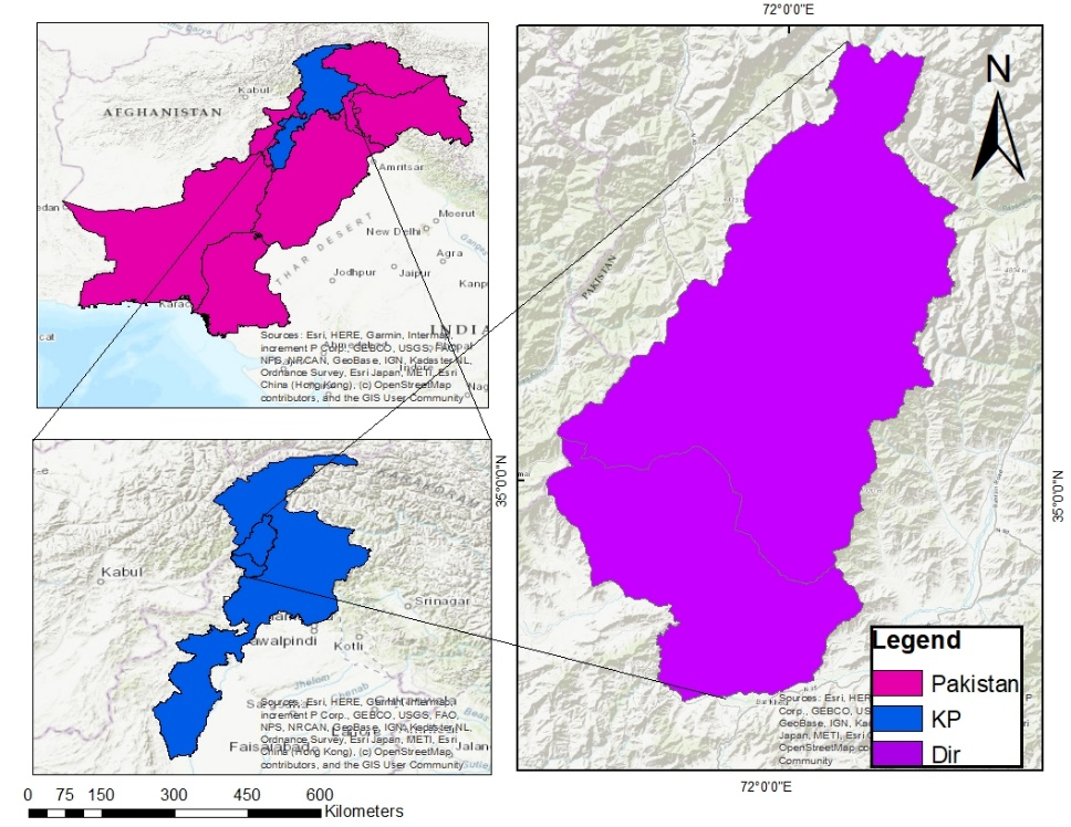
Soil erosion is a global concern, influenced by terrain, vegetation, soil, and climate factors. Traditionally, field-based techniques have been utilized for the measurement of soil erosion. In the present study, Remote Sensing and Geographic Information System (RS/GIS) techniques are used for soil erosion estimation. The Revised Universal Soil Loss Equation (RUSLE) is frequently utilized, incorporating various elements such as soil erodibility, rainfall erosivity, slope steepness, Land Use and Land Cover (LULC), and conservation practices. This study focuses on the Dir district in Pakistan, integrating the RUSLE model with RS and GIS to identify soil erosion-prone areas. The goal is to implement targeted interventions and sustainable land management practices to mitigate soil erosion in these areas. The output of the RUSLE model identifies key zones that need to be addressed to prevent further land degradation. This study also indicates higher C-factor values in Upper and Lower Dir, ranging from 0.001 to 0.2. Soil loss was calculated using all factors (R, K, LS, CP), showing that soil loss is approximately 31.6 tons/ha/yr in Upper Dir and 22.88 tons/ha/yr in Lower Dir, which is higher in Upper Dir due to high elevation (>30m) and more rainfall in Upper Dir (1275mm). Furthermore, annual rainfall values ranging from 508 mm to 1275 mm were noted, resulting in maximum rainfall erosivity values of 572.87 MJ mm ha/h/year in Upper Dir and 568.16 MJ mm ha/h/year in Lower Dir. Thus, this study provides critical data for society and policymakers to implement targeted soil conservation measures and sustainable land management systems, thereby mitigating soil erosion and preventing further land degradation in the district of Dir.
References
W. E. H. . Blum, P. Schad, and S. Nortcliff, “Essentials of soil science : soil formation, functions, use and classification (World Reference Base, WRB),” Sci., p. 171, 2018, Accessed: Aug. 10, 2025. [Online]. Available: https://dokumen.pub/essentials-of-soil-science-soil-formation-functions-use-and-classification-world-reference-base-wrb-3443010903-9783443010904.html
D. P. Finlayson and David R. Montgomery, “Modeling large-scale fluvial erosion in geographic information systems,” Geomorphology, vol. 53, no. 1–2, pp. 147–164, 2003, doi: https://doi.org/10.1016/S0169-555X(02)00351-3.
P. P. Dabral, N. Baithuri, and A. Pandey, “Soil erosion assessment in a hilly catchment of North Eastern India using USLE, GIS and remote sensing,” Water Resour. Manag., vol. 22, no. 12, pp. 1783–1798, Mar. 2008, doi: 10.1007/S11269-008-9253-9/METRICS.
D. J. P. Luca Montanarella, “World’s soils are under threat,” SOIL, vol. 2, pp. 79–82, 2016, doi: https://doi.org/10.5194/soil-2-79-2016.
D. Rozos, H. D. Skilodimou, C. Loupasakis, and G. D. Bathrellos, “Application of the revised universal soil loss equation model on landslide prevention. An example from N. Euboea (Evia) Island, Greece,” Environ. Earth Sci., vol. 70, no. 7, pp. 3255–3266, Dec. 2013, doi: 10.1007/S12665-013-2390-3/METRICS.
S. Pandey and N. Kumari, “Prediction and monitoring of LULC shift using cellular automata-artificial neural network in Jumar watershed of Ranchi District, Jharkhand,” Environ. Monit. Assess., vol. 195, no. 1, pp. 1–24, Jan. 2023, doi: 10.1007/S10661-022-10623-6/METRICS.
J. M. E.F. Lambin, H.K. Gibbs, L. Ferreira, R. Grau, P. Mayaux, P. Meyfroidt, D.C. Morton, T.K. Rudel, I. Gasparri, “Estimating the world’s potentially available cropland using a bottom-up approach,” Glob. Environ. Chang., vol. 23, no. 5, pp. 892–901, 2013, doi: https://doi.org/10.1016/j.gloenvcha.2013.05.005.
S. D. Keesstra et al., “The significance of soils and soil science towards realization of the United Nations sustainable development goals,” Soil, vol. 2, no. 2, pp. 111–128, 2016, doi: 10.5194/soil-2-111-2016.
M. Irshad, M. Inoue, M. Ashraf, Faridullah, H. K. M. Delower, and A. Tsunekawa, “Land Desertification-An Emerging Threat to Environment and Food Security of Pakistan,” J. Appl. Sci., vol. 7, no. 8, pp. 1199–1205, Apr. 2007, doi: 10.3923/JAS.2007.1199.1205.
A. Shalaby and Ryutaro Tateishi, “Remote sensing and GIS for mapping and monitoring land cover and land-use changes in the Northwestern coastal zone of Egypt,” Appl. Geogr., vol. 27, no. 1, pp. 28–41, 2007, doi: https://doi.org/10.1016/j.apgeog.2006.09.004.
R. A. George Ashiagbor, Eric Kwabena Forkuo, Prosper Laari, “Modeling soil erosion using RUSLE and GIS tools,” ResearchGate, 2012, [Online]. Available: https://www.researchgate.net/publication/256945864_Modeling_soil_erosion_using_RUSLE_and_GIS_tools
C. C. Nnaji, C. N. Mama, and O. Ukpabi, “Hierarchical analysis of rainfall variability across Nigeria,” Theor. Appl. Climatol., vol. 123, no. 1–2, pp. 171–184, Jan. 2016, doi: 10.1007/S00704-014-1348-Z/METRICS.
“Predicting rainfall erosion losses: a guide to conservation planning.” Accessed: May 21, 2024. [Online]. Available: https://www3.epa.gov/npdes/pubs/ruslech2.pdf
H. S.-K. Pawanjeet S. Datta, “Erosion Relevant Topographical Parameters Derived from Different DEMs—A Comparative Study from the Indian Lesser Himalayas,” Remote Sens, vol. 2, no. 8, pp. 1941–1961, 2010, doi: https://doi.org/10.3390/rs2081941.
K. Ghosal and S. Das Bhattacharya, “A Review of RUSLE Model,” J. Indian Soc. Remote Sens., vol. 48, no. 4, pp. 689–707, Apr. 2020, doi: 10.1007/S12524-019-01097-0/METRICS.
D. A. R. Toby N. Carlson, “On the relation between NDVI, fractional vegetation cover, and leaf area index,” Remote Sens. Environ., vol. 62, no. 3, pp. 241–252, 1997, doi: https://doi.org/10.1016/S0034-4257(97)00104-1.
F. Uddin and K. Zakir, “Glacial Recession processes and Glacial Lake inventories in High Mountain Asian Communities,” SSRN Electron. J., Aug. 2024, doi: 10.2139/SSRN.5245546.
A. Ashraf and I. Ahmad, “Evaluation of soil loss severity and ecological restoration approach for sustainable agriculture in the Hindu Kush, Karakoram and Himalaya region,” J. Mt. Sci., vol. 21, no. 5, pp. 1509–1521, May 2024, doi: 10.1007/S11629-023-8385-Y/METRICS.
Downloads
Published
How to Cite
License
Copyright (c) 2025 50sea

This work is licensed under a Creative Commons Attribution 4.0 International License.


