
Estimating Soil Erosion Risk in District Diamer, Pakistan Using RUSLE Model: A Spatial Analysis Approach
Keywords:
Remote sensing, GIS, Soil Erosion, Revised Universal Soil Loss Equation, Land-use & Land-coverAbstract
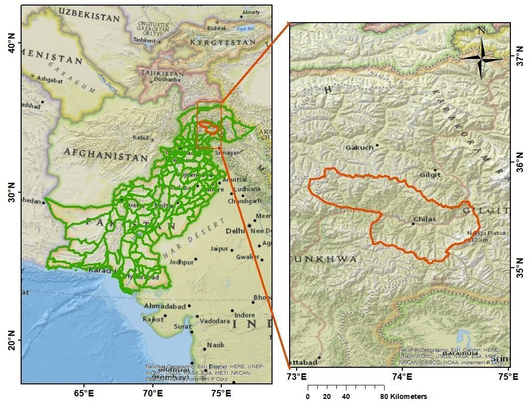
Soil erosion is a critical issue in the hilly regions of Diamer, Pakistan, due to the region's varying topography and significant precipitation patterns. This study uses an effective combination of Geographic Information System (GIS) technologies and the Revised Universal Soil Loss Equation (RUSLE) model to calculate soil erosion rates within the region's complex topography. Different GIS layers, such as rainfall erosivity (R), slope length and steepness (LS) factor, soil erodibility (K), conservation practices (P), and cover management factor (C), were merged by utilizing satellite data and the Normalized Difference Vegetation Index (NDVI). The resulting map showed a maximum soil loss of 2279.3 t/ha/year over the region. Notably, the greatest soil loss was observed in the western regions of Diamer, where rainfall and rainfall erosivity are also recorded as high in these areas. Five separate categories of soil erosion were identified, with a mean soil loss rate of 27 t/ha/year. According to the GIS analysis, 95% of the overall area experienced less severe erosion than the severe erosion classes, accounting for 5%. Additionally, the study included the computation of composite NDVI estimates for 2023 using Google Earth Engine (GEE). This method improved both the scalability and usability of the study by enabling effective processing and storage of data in the cloud. GEE enables the computation of NDVI quickly and precisely. This pioneering study is an important step toward understanding and resolving soil erosion issues in Diamer, Pakistan. The study offers valuable insights for decision-making and management planning initiatives by utilizing cutting-edge GIS tools and RUSLE modeling.
References
K. H. Jodhani, D. Patel, N. Madhavan, and S. K. Singh, “Soil Erosion Assessment by RUSLE, Google Earth Engine, and Geospatial Techniques over Rel River Watershed, Gujarat, India,” Water Conserv. Sci. Eng., vol. 8, no. 1, pp. 1–17, Dec. 2023, doi: 10.1007/S41101-023-00223-X/METRICS.
C. S. P. O. Shishant Gupta, “Pixel-Based Soil Loss Estimation and Prioritization of North-Western Himalayan Catchment Based on Revised Universal Soil Loss Equation (RUSLE),” Sustainability, vol. 15, no. 20, p. 15177, 2023, doi: https://doi.org/10.3390/su152015177.
D. V. V. Narayana and R. Babu, “Estimation of Soil Erosion in India,” J. Irrig. Drain. Eng., vol. 109, no. 4, pp. 419–434, Dec. 1983, doi: 10.1061/(ASCE)0733-9437(1983)109:4(419).
M. S. B. Alam, Shaista, Ambreen Fatima, “Sustainable development in Pakistan in the context of energy consumption demand and environmental degradation,” J. Asian Econ., vol. 18, no. 5, pp. 825–837, 2007, doi: https://doi.org/10.1016/j.asieco.2007.07.005.
P. S. Sanjay K. Jain, “Assessment of sedimentation in Bhakra Reservoir in the western Himalayan region using remotely sensed data,” Hydrol. Sci. J., vol. 47, no. 2, pp. 203–212, 2002, doi: https://doi.org/10.1080/02626660209492924.
W. Peng, Z. Zhang, and K. Zhang, “Hydrodynamic characteristics of rill flow on steep slopes,” Hydrol. Process., vol. 29, no. 17, pp. 3677–3686, Aug. 2015, doi: 10.1002/HYP.10461;JOURNAL:JOURNAL:10991085.
H. Gilani, A. Ahmad, I. Younes, and S. Abbas, “Estimation of annual soil erosion dynamics (2005 - 2015) in Pakistan using Revised Universal Soil Loss Equation (RUSLE),” Authorea Prepr., Jan. 2021, doi: 10.22541/AU.160946369.92099648/V1.
I. Rahim, S. M. Ali, M. Aslam, I. Rahim, S. M. Ali, and M. Aslam, “GIS Based Landslide Susceptibility Mapping with Application of Analytical Hierarchy Process in District Ghizer, Gilgit Baltistan Pakistan,” J. Geosci. Environ. Prot., vol. 6, no. 2, pp. 34–49, Feb. 2018, doi: 10.4236/GEP.2018.62003.
A. & F. Ahmad, D., Hafeez, F., Irshad, M., Mehmood, Q., Tahir, A. A., Iqbal, “Gilgit-Baltistan,” Arab. J. Geosci., vol. 13, p. 1286, 2020.
Kenneth Hewitt, “Catastrophic landslides and their effects on the Upper Indus streams, Karakoram Himalaya, northern Pakistan,” Geomorphology, vol. 26, no. 1–3, pp. 47–80, 1998, doi: https://doi.org/10.1016/S0169-555X(98)00051-8.
C. Hawas Khan, Muhammad Shafique, Muhammad A. Khan, Mian A. Bacha, Safeer U. Shah, Calligaris, “Landslide susceptibility assessment using Frequency Ratio, a case study of northern Pakistan,” Egypt. J. Remote Sens. Sp. Sci., vol. 22, no. 1, pp. 11–24, 2019, doi: https://doi.org/10.1016/j.ejrs.2018.03.004.
P. Thapa, “Spatial Estimation of Soil Erosion Using RUSLE Modeling: A case study of Dolakha District, Nepal,” Jul. 2020, doi: 10.21203/RS.3.RS-25478/V4.
A. A. Karim, F., Ashraf, M. I., Amin, M., Khan, M. R., & Khan, “Impact of climatic factors on land-use changes using geo-spatial techniques,” J. Appl. Agric. Biotechnol., vol. 1, no. 2, pp. 58–68, 2016, [Online]. Available: https://www.researchgate.net/publication/344538415_Impact_of_climatic_factors_on_land-use_changes_using_geo-spatial_techniques
D. . Wischmeier, W.H. and Smith, “Predicting Rainfall Erosion Losses,” A Guid. to Conserv. Planning. USDA Agric. Handb., 1978, [Online]. Available: https://www.scirp.org/reference/referencespapers?referenceid=1687723
A. Ashraf and I. Ahmad, “Evaluation of soil loss severity and ecological restoration approach for sustainable agriculture in the Hindu Kush, Karakoram and Himalaya region,” J. Mt. Sci., vol. 21, no. 5, pp. 1509–1521, May 2024, doi: 10.1007/S11629-023-8385-Y/METRICS.
S. Ghosh, “An Assessment of RUSLE Model and Erosion Vulnerability in the Slopes of Dwarka–Brahmani Lateritic Interfluve, Eastern India,” Clim. Environ. Disaster Dev. Ctries. , pp. 475–506, 2022, doi: 10.1007/978-981-16-6966-8_26.
D. K. McCool, L. C. Brown, G. R. Foster, C. K. Mutchler, and L. D. Meyer, “Revised Slope Steepness Factor for the Universal Soil Loss Equation,” Trans. ASAE, vol. 30, no. 5, pp. 1387–1396, Sep. 1987, doi: 10.13031/2013.30576.
B. LE Moore, I. D, Turner AK, Wilson JP, Jenson SK, “GIS and land-surface-subsurface process modeling,” Goodchild MF Environ. Model. with GISOxford Univ. Press. U.K, 1993, [Online]. Available: https://www.researchgate.net/publication/246324435_GIS_and_land-surface-subsurface_process_modeling
K. Ghosal and S. Das Bhattacharya, “A Review of RUSLE Model,” J. Indian Soc. Remote Sens., vol. 48, no. 4, pp. 689–707, Apr. 2020, doi: 10.1007/S12524-019-01097-0/METRICS.
M. A. Rather, J. Satish Kumar, M. Farooq, and H. Rashid, “Assessing the influence of watershed characteristics on soil erosion susceptibility of Jhelum basin in Kashmir Himalayas,” Arab. J. Geosci., vol. 10, no. 3, pp. 1–25, Feb. 2017, doi: 10.1007/S12517-017-2847-X/METRICS.
G. R. C. Nazir Ahmad, “Irrigated Agriculture of Pakistan,” Groundwater, 1988, [Online]. Available: https://books.google.com.pk/books/about/Irrigated_Agriculture_of_Pakistan.html?id=Fn4_AAAAYAAJ&redir_esc=y
J. A. Oliveira, J. M. L. Dominguez, M. A. Nearing, and P. T. S. Oliveira, “A GIS-Based procedure for automatically calculating soil loss from the universal soil loss Equation: GISus-M,” Appl. Eng. Agric., vol. 31, no. 6, pp. 907–917, 2015, doi: 10.13031/AEA.31.11093.
V. L. D. Daniel Fonseca de Carvalho, “Predicting soil erosion using Rusle and NDVI time series from TM Landsat 5,” Pesqui. Agropecu. Bras., 2014, doi: 10.1590/S0100-204X2014000300008.
I. Z. G. S. Papaiordanidis, “Soil erosion prediction using the Revised Universal Soil Loss Equation (RUSLE) in Google Earth Engine (GEE) cloud-based platform,” Bull. V.V. Dokuchaev Soil Inst., 2019, doi: https://doi.org/10.19047/0136-1694-2019-100-36-52.
C. L. Arnold and C. J. Gibbons, “Impervious Surface Coverage: The Emergence of a Key Environmental Indicator,” J. Am. Plan. Assoc., vol. 62, no. 2, pp. 243–258, 1996, doi: 10.1080/01944369608975688.
S. T. Pooja Koirala, “Estimation of Soil Erosion in Nepal Using a RUSLE Modeling and Geospatial Tool,” Geosciences, vol. 9, no. 4, p. 147, 2019, doi: https://doi.org/10.3390/geosciences9040147.
A. Ashraf, “Risk modeling of soil erosion under different land use and rainfall conditions in Soan river basin, sub-Himalayan region and mitigation options,” Model. Earth Syst. Environ., vol. 6, no. 1, pp. 417–428, Mar. 2020, doi: 10.1007/S40808-019-00689-6/METRICS.
R. Lal, “Soil Erosion in the Tropics: Principles and Management,” McGraw Hill, vol. 588, 1990, [Online]. Available: https://www.scirp.org/reference/referencespapers?referenceid=2193850
A. Khan, A. U. Rahman, and S. Mahmood, “Spatial estimation of soil erosion risk using RUSLE model in District Swat, Eastern Hindu Kush, Pakistan,” J. Water Clim. Chang., vol. 14, no. 6, pp. 1881–1899, Jun. 2023, doi: 10.2166/WCC.2023.495/1246359/JWC0141881.PDF.
S. R. Kashiwar, M. C. Kundu, and U. R. Dongarwar, “Soil erosion estimation of Bhandara region of Maharashtra, India, by integrated use of RUSLE, remote sensing, and GIS,” Nat. Hazards, vol. 110, no. 2, pp. 937–959, Jan. 2022, doi: 10.1007/S11069-021-04974-5/METRICS.
B. J. B. and J. C. H. C.T. Haan, “Design Hydrology and Sedimentology for Small Catchments,” Elsevier, 1994, [Online]. Available: https://www.sciencedirect.com/book/9780123123404/design-hydrology-and-sedimentology-for-small-catchments
V. Prasannakumar, R. Shiny, N. Geetha, and H. Vijith, “Spatial prediction of soil erosion risk by remote sensing, GIS and RUSLE approach: A case study of Siruvani river watershed in Attapady valley, Kerala, India,” Environ. Earth Sci., vol. 64, no. 4, pp. 965–972, Oct. 2011, doi: 10.1007/S12665-011-0913-3/METRICS.
H. Gilani, A. Ahmad, I. Younes, and S. Abbas, “Impact assessment of land cover and land use changes on soil erosion changes (2005–2015) in Pakistan,” L. Degrad. Dev., vol. 33, no. 1, pp. 204–217, Jan. 2022, doi: 10.1002/LDR.4138.
C.-U. Hwang, Chang-Su ; Kim, Kyung-Tag, Oh, Che-Young ; Jin, Cheong-Gil, Choi, “A Study on Correlation between RUSLE and Estuary in Nakdong River Watershed,” J. Korean Soc. Geospatial Inf. Sci., vol. 18, no. 3, pp. 3–10, 2010, [Online]. Available: https://koreascience.kr/article/JAKO201019547057082.pub?&lang=en
M. K. L. Muhammad Waseem, Fahad Iqbal, Muhammad Humayun, Muhammad Umais Latif, Tayyaba Javed, “Spatial Assessment of Soil Erosion Risk Using RUSLE Embedded in GIS Environment: A Case Study of Jhelum River Watershed,” Appl. Sci., vol. 13, no. 6, p. 3775, 2023, doi: https://doi.org/10.3390/app13063775.
Downloads
Published
How to Cite
License
Copyright (c) 2025 50sea

This work is licensed under a Creative Commons Attribution 4.0 International License.


