
Geo-Spatial Analysis to Access Land Slide Susceptibility in Tehsil Balakot, District Mansehra, Pakistan
DOI:
https://doi.org/10.33411/ijist/20257321042116Keywords:
GIS, LSM, Balakot, HazardAbstract
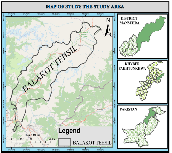
Land slides are one of the recurrent natural problems that are widespread throughout the world, especially in mountainous areas, which cause significant injuries and loss of human lives, damage to properties and infrastructures. The term “landslide” is the movement of a mass of rock, debris, or earth down a slope under the influence of gravity. Landslide hazard mapping is a fundamental tool for disaster management activities in fragile mountainous terrains. The main purpose of this study was to find out landslide hazard assessment by bivariate statistical modelling and prepare an optimized mitigation map of the tehsil Balakot. The modelling was performed using a geographical information system (GIS) to derive a landslide hazard map of the tehsil Balakot. To achieve the objectives of the study, two types of variables, that is, dependent variables and independent variables, were used. The dependent variable that was selected for study was landslide occurrences. As a mandatory part of the study, the sites of previous landslides were collected from Google Earth Pro software, and a consecutive field visit was also conducted to validate the landslide sites on the ground. The Independent variables were the landslide causal factors. The causal factors that were used to achieve the objectives are Slope, Aspect, Curvature, NDWI, NDVI, Geological map, Elevation, and River distance network. The DEM data, Sentinel-2 data, and regional geologic map were used to process the landslide causal factors. The information value model was used for assessing the landslide susceptibility. The landslide susceptibility map was evaluated using the ROC curve. The result of the AUC curve was 78.71% which indicated good accuracy in the identification of the landslide susceptibility zone in a region
References
I. R. and M. J. N. G G Benineza, “Landslides hazards assessment using geographic information system and remote sensing: Gakenke District,” IOP Conf. Ser. Earth Environ. Sci, vol. 389, 2019, [Online]. Available: 10.1088/1755-1315/389/1/012015
A. C. M. Rodeano Roslee, “Landslide susceptibility analysis lsa using weighted overlay method wom along the genting sempah to bentong highway pahang,” Malaysian J. Geosci., vol. 1, no. 2, 2017, doi: 10.26480/mjg.02.2017.13.19.
J. D. Greenberg, M. G. Logsdon, and J. F. Franklin, “Introduction to Geographic Information Systems (GIS),” Learn. Landsc. Ecol., pp. 17–31, Apr. 2002, doi: 10.1007/0-387-21613-8_3.
G. S. B. Pravat Kumar Shit, “Potential landslide susceptibility mapping using weighted overlay model (WOM),” Model. Earth Syst. Environ., vol. 2, no. 21, 2016, [Online]. Available: https://link.springer.com/article/10.1007/s40808-016-0078-x
B. F. D. Wahono and M. S. D. S. Hadmoko, “Applications of statistical and heuristic methods for landslide susceptibility assessments :: A case study in Wadas Lintang Sub Distric, Wonosobo Regency Central Java Province Indonesia,” 2010.
B. K. B. Prakash Biswakarma, “Landslide Susceptibility Mapping in East Sikkim Region of Sikkim Himalaya Using High Resolution Remote Sensing Data and GIS techniques,” Appl. Ecol. Environ. Sci., vol. 8, no. 4, pp. 143–153, 2020, doi: 10.12691/aees-8-4-1.
M. S. K. M F Ahmed, “SLOPE FAILURE ANALYSIS OF HAVELIAN LANDSLIDE, ABBOTTABAD PAKISTAN,” Pak. J. Sci., vol. 68, no. 3, 2016, [Online]. Available: https://nja.pastic.gov.pk/PJS/index.php/PJS/article/view/1014
M. I. Fazal Ullah, “Quantitative Assessment of the Medicinal Flora of Gadoon valley, District Swabi, Khyber Pakhtunkhwa, Pakistan,” Ethnobot. Res. Appl., vol. 7, pp. 1–18, 20242, [Online]. Available: https://ethnobotanyjournal.org/index.php/era/article/view/6045
W. M. Muhammad Irfan, Danish Ali, Gul Jan, “Ethnobotanical Survey of the Flora of Tehsil Balakot, District Mansehra, Khyber Pakhtunkhwa, Pakistan,” Spec. J. Biol. Sci., vol. 4, no. 3, 2018, [Online]. Available: https://sciarena.com/article/ethnobotanical-survey-of-the-flora-of-tehsil-balakot-district-mansehra-khyber-pakhtunkhwa-pakistan
A. G. Gangaram Biswakarma, “Antecedent of service innovation effectiveness in small and medium enterprises: a case of hospitality sector in Nepal,” Int. J. Oper. Res., vol. 9, no. 1, pp. 9–31, 2020, doi: 10.3126/ijorn.v9i1.51843.
M. U. B. Adnan Ullah, “Assessing the Transformative Influence of ChatGPT on Research Practices among Scholars in Pakistan,” Mesopotamian J. Big Data, vol. 2024, 2024, [Online]. Available: https://mesopotamian.press/journals/index.php/bigdata/article/view/234
Downloads
Published
How to Cite
Issue
Section
License
Copyright (c) 2025 50sea

This work is licensed under a Creative Commons Attribution 4.0 International License.


