
Development of A Web based GIS Solution for Flood Inundation Mapping and Assessment in Lahore, Pakistan
DOI:
https://doi.org/10.33411/ijist/2023050201Keywords:
Geo Server WMS Animator, PostgreSQL, Geo Server, JavaScript, HEC-RAS, Flood inundation, Web GIS, Remote sensingAbstract
Introduction
Geographic information system (GIS) is a strong tool in flood hazard mapping, mitigation, and management. GIS-based approaches provide the wayforward to measure the flood inundation. Integration of web technologies with GIS (Web-GIS) is quite significant to accomplish the aim.
Methodology
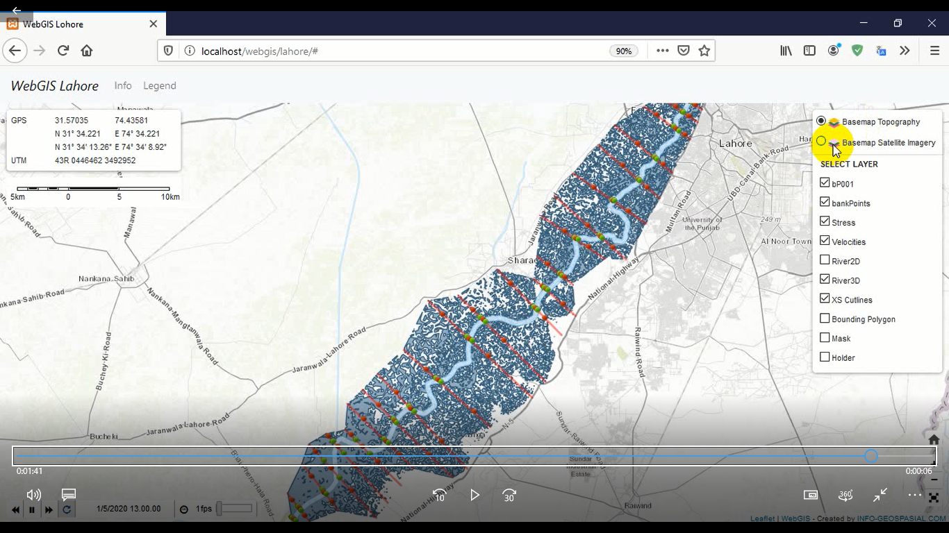
In this research, HEC-RAS 1D was used to map the flooded areas around River Ravi at Lahore. The output of HEC-RAS with Web-GIS stack were used to build the interactive flood measuring tool. The Web-GIS stack used for this study was based on Geo Server, PHP, HTML, CSS, and JavaScript. Geo Server provides the OGC implemented standards with vendor specific capabilities like WMS Animator to animate the flood inundation on the User-Interface (UI) and extent animation to make visual interpretations. CQL filter is vendor specific capability in Geo Server used to measure the flood inundation.
Results
The outcomes of HEC-RAS are handy enough to measure, map and present the damages not only to analyst but also to the layman. The working and animated layers are shown in result section of this research.
Conclusion
This web-based flood inundation is robust, user-friendly, and expandable for more features, scenarios, and conditions. This research concludes that visual and web-based data is handy to understand for common person/intellectuals.
References
S. R. A. Mehreen Akhtar, Saira Akram, Sumaira Hafeez, Basit Nazeer, “Development of A Web based GIS Solution for Flood Inundation Mapping and Assessment in Lahore, Pakistan,” Int. J. Innov. Sci. Technol., vol. 5, no. 2, pp. 111–121, 2023.
K. Uddin, D. R. Gurung, A. Giriraj, and B. Shrestha, “Application of Remote Sensing and GIS for Flood Hazard Management: A Case Study from Sindh Province, Pakistan,” Am. J. Geogr. Inf. Syst., vol. 2, no. 1, pp. 1–5, Dec. 2013, doi: 10.5923/J.AJGIS.20130201.01.
T. Tingsanchali, “Urban flood disaster management,” Procedia Eng., vol. 32, pp. 25–37, Jan. 2012, doi: 10.1016/J.PROENG.2012.01.1233.
A. T. N. Dang and L. Kumar, “Application of remote sensing and GIS-based hydrological modelling for flood risk analysis: a case study of District 8, Ho Chi Minh city, Vietnam,” http://www.tandfonline.com/action/journalInformation?show=aimsScope&journalCode=tgnh20#.VsXodSCLRhE, vol. 8, no. 2, pp. 1792–1811, Dec. 2017, doi: 10.1080/19475705.2017.1388853.
K. Khosravi et al., “A comparative assessment of flood susceptibility modeling using Multi-Criteria Decision-Making Analysis and Machine Learning Methods,” J. Hydrol., vol. 573, pp. 311–323, Jun. 2019, doi: 10.1016/J.JHYDROL.2019.03.073.
A. A. Memon, S. Muhammad, S. Rahman, and M. Haq, “Flood monitoring and damage assessment using water indices: A case study of Pakistan flood-2012,” Egypt. J. Remote Sens. Sp. Sci., vol. 18, no. 1, pp. 99–106, Jun. 2015, doi: 10.1016/J.EJRS.2015.03.003.
K. Chohan et al., “Riverine Flood Damage Assessment of Cultivated Lands along Chenab River Using GIS and Remotely Sensed Data: A Case Study of District Hafizabad, Punjab, Pakistan,” J. Geogr. Inf. Syst., vol. 7, no. 5, pp. 506–526, Sep. 2015, doi: 10.4236/JGIS.2015.75041.
S. Mourato, P. Fernandez, F. Marques, A. Rocha, and L. Pereira, “An interactive Web-GIS fluvial flood forecast and alert system in operation in Portugal,” Int. J. Disaster Risk Reduct., vol. 58, p. 102201, May 2021, doi: 10.1016/J.IJDRR.2021.102201.
S. Steiniger and A. J. S. Hunter, “The 2012 free and open source GIS software map – A guide to facilitate research, development, and adoption,” Comput. Environ. Urban Syst., vol. 39, pp. 136–150, May 2013, doi: 10.1016/J.COMPENVURBSYS.2012.10.003.
A. T. Kulkarni, J. Mohanty, T. I. Eldho, E. P. Rao, and B. K. Mohan, “A web GIS based integrated flood assessment modeling tool for coastal urban watersheds,” Comput. Geosci., vol. 64, pp. 7–14, Mar. 2014, doi: 10.1016/J.CAGEO.2013.11.002.
J. Zavala-Hidalgo, A. Fernández-Eguiarte, R. Romero-Centeno, and O. Zavala-Romero, “Digital Atlas of Mexico Provides Accessible Climate Information,” Eos, Trans. Am. Geophys. Union, vol. 91, no. 14, pp. 125–126, Apr. 2010, doi: 10.1029/2010EO140001.
I. Demir et al., “Data-Enabled Field Experiment Planning, Management, and Research Using Cyberinfrastructure,” J. Hydrometeorol., vol. 16, no. 3, pp. 1155–1170, Jun. 2015, doi: 10.1175/JHM-D-14-0163.1.
P. H. Hsu, S. Y. Wu, and F. T. Lin, “Disaster management using GIS technology: A case study in Taiwan.” pp. 1510–1519, 2005. Accessed: Apr. 25, 2023. [Online]. Available: https://researchoutput.ncku.edu.tw/en/publications/disaster-management-using-gis-technology-a-case-study-in-taiwan
W. F. Krajewski et al., “Real-Time Flood Forecasting and Information System for the State of Iowa,” Bull. Am. Meteorol. Soc., vol. 98, no. 3, pp. 539–554, Mar. 2017, doi: 10.1175/BAMS-D-15-00243.1.
Z. C. Aye, T. Sprague, V. J. Cortes, K. Prenger-Berninghoff, M. Jaboyedoff, and M. H. Derron, “A collaborative (web-GIS) framework based on empirical data collected from three case studies in Europe for risk management of hydro-meteorological hazards,” Int. J. Disaster Risk Reduct., vol. 15, pp. 10–23, Mar. 2016, doi: 10.1016/J.IJDRR.2015.12.001.
I. Demir, E. Yildirim, Y. Sermet, and M. A. Sit, “FLOODSS: Iowa flood information system as a generalized flood cyberinfrastructure,” https://doi.org/10.1080/15715124.2017.1411927, vol. 16, no. 3, pp. 393–400, Jul. 2017, doi: 10.1080/15715124.2017.1411927.
E. Yildirim and I. Demir, “An integrated web framework for HAZUS-MH flood loss estimation analysis,” Nat. Hazards, vol. 99, no. 1, pp. 275–286, Oct. 2019, doi: 10.1007/S11069-019-03738-6/METRICS.
H. J. Henriksen, M. J. Roberts, P. van der Keur, A. Harjanne, D. Egilson, and L. Alfonso, “Participatory early warning and monitoring systems: A Nordic framework for web-based flood risk management,” Int. J. Disaster Risk Reduct., vol. 31, pp. 1295–1306, Oct. 2018, doi: 10.1016/J.IJDRR.2018.01.038.
“(PDF) WebGIS for water level monitoring and flood forecasting using Open Source Technology.” https://www.researchgate.net/publication/343181650_WebGIS_for_water_level_monitoring_and_flood_forecasting_using_Open_Source_Technology (accessed Apr. 25, 2023).
“GeoServer The Open Source Solution for the interoperable management of geospatial data @ GFOSS Day 2013.” https://www.slideshare.net/geosolutions/geoserver-the-open-source-solution-for-the-interoperable-management-of-geospatial-data (accessed Apr. 25, 2023).
Z. Huang and Z. Xu, “A method of using geoserver to publish Economy Geographical Information,” 2011 Int. Conf. Control. Autom. Syst. Eng. CASE 2011, 2011, doi: 10.1109/ICCASE.2011.5997789.
M. Bhandari, N. Nyaupane, S. R. Mote, A. Kalra, and S. Ahmad, “2D Unsteady Flow Routing and Flood Inundation Mapping for Lower Region of Brazos River Watershed,” World Environ. Water Resour. Congr. 2017 Hydraul. Waterw. Water Distrib. Syst. Anal. - Sel. Pap. from World Environ. Water Resour. Congr. 2017, pp. 292–303, 2017, doi: 10.1061/9780784480625.027.
A. Viloria, G. C. Acuña, D. J. A. Franco, H. Hernández-Palma, J. P. Fuentes, and E. P. Rambal, “Integration of Data Mining Techniques to PostgreSQL Database Manager System,” Procedia Comput. Sci., vol. 155, pp. 575–580, Jan. 2019, doi: 10.1016/J.PROCS.2019.08.080.
M. G. Jung, S. A. Youn, J. Bae, and Y. L. Choi, “A study on data input and output performance comparison of MongoDB and PostgreSQL in the big data environment,” Proc. - 8th Int. Conf. Database Theory Appl. DTA 2015, pp. 14–17, Mar. 2016, doi: 10.1109/DTA.2015.14.
A. Alshamrani and A. Bahattab, “A Comparison Between Three SDLC Models Waterfall Model, Spiral Model, and Incremental/Iterative Model”, Accessed: Apr. 25, 2023. [Online]. Available: www.IJCSI.org
D. Edler and M. Vetter, “The Simplicity of Modern Audiovisual Web Cartography: An Example with the Open-Source JavaScript Library leaflet.js,” KN - J. Cartogr. Geogr. Inf., vol. 69, no. 1, pp. 51–62, May 2019, doi: 10.1007/S42489-019-00006-2/FIGURES/13.
K. Kalabokidis et al., “Virtual Fire: A web-based GIS platform for forest fire control,” Ecol. Inform., vol. 16, pp. 62–69, Jul. 2013, doi: 10.1016/J.ECOINF.2013.04.007.
Published
How to Cite
Issue
Section
License
Copyright (c) 2023 50SEA

This work is licensed under a Creative Commons Attribution 4.0 International License.


