
Modernizing Land Records in Tulumba Through GIS: Massavi Reconstruction Under the Pulse Project
DOI:
https://doi.org/10.33411/IJIST/1471Keywords:
Digital Massavi, GIS, Land Records, Punjab, Georeferencing, Spatial Data ManagementAbstract
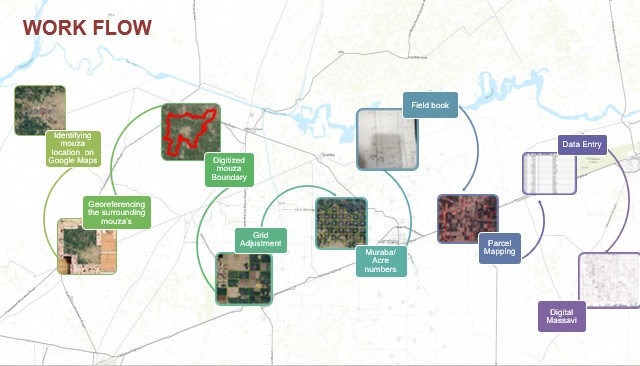
This research presents a comprehensive methodology for developing digital Massavis (land record maps) using Geographic Information System (GIS) technologies to address persistent challenges in land record management. The study focuses on the Punjab Urban Land System Enhancement Project (PULSE), specifically examining the digitization of Mouza Tulamba in District Khanewal. Through systematic georeferencing, boundary digitization, and grid adjustment techniques, this study demonstrates how digital technologies can overcome traditional limitations in land record management, including unavailable or damaged physical records and staff reluctance to create new maps. The methodology successfully processed 207 Murabajaat covering 4,189 acres with 8,052 Khasra records, establishing a replicable framework for digital land record transformation.
References
P. Zahir ALI and Abdul NASIR, “Land Administration System in Pakistan - Current Situation and Stakeholders’ Perception,” XXIV FIG Congr. 2010 "Facing Challenges - Build. Capacit., 2010, [Online]. Available: https://www.researchgate.net/publication/215766308_Land_Administration_System_in_Pakistan_-_Current_Situation_and_Stakeholders’_Perception
E. H. Muhammad Sheraz Ahsan, “Deriving requirements for integrated and standardised cadastre profile from the legacy Board of Revenue and the contemporary land administration systems,” Surv. Rev., vol. 57, no. 401, 2025, [Online]. Available: https://www.tandfonline.com/doi/full/10.1080/00396265.2024.2351624
S. C. Crommelinck, “Automating image-based cadastral boundary mapping,” Univ. Twente, vol. 10, 2019, [Online]. Available: https://research.utwente.nl/en/publications/automating-image-based-cadastral-boundary-mapping
L. J. S. P. Carmen Femenia-Ribera, Gaspar Mora-Navarro, “Evaluating the use of old cadastral maps,” Land use policy, vol. 114, p. 105984, 2022, doi: https://doi.org/10.1016/j.landusepol.2022.105984.
Atta Ur Rehman, Waqar Ahmad, Zahid Khan, “Application of GIS Based Re-Settlement of Land Record of Mouza Shahbat Khel, District Mardan (Pakistan),” J. Asian Dev. Stud., vol. 13, no. 3, pp. 1467–1481, 2024, doi: 10.62345/jads.2024.13.3.119.
T. J. Martin Tauchman, “Positional accuracy of cadastral maps digitized from the stable cadastre system,” Stavební Obz. - Civ. Eng. J., vol. 33, no. 2, p. 7, 2024, [Online]. Available: http://ojs.cvut.cz/ojs/index.php/cej/article/view/9892
M. Ali, “Modernizing land records: Pakistan’s journey from patwaris to digital GIS-based systems,” Asian J. Geoinformatics, vol. 19, no. 4, pp. 57–64, 2019.
M. P. Václav Šafář, “The Use of UAV in Cadastral Mapping of the Czech Republic,” ISPRS Int. J. Geo-Inf, vol. 10, no. 6, p. 380, 2021, doi: https://doi.org/10.3390/ijgi10060380.
A. K. Burak Uşak, Volkan Çağdaş, “Current Cadastral Trends—A Literature Review of the Last Decade,” Land, vol. 13, no. 12, p. 2100, 2024, doi: https://doi.org/10.3390/land13122100.
P. Golob and A. Lisec, “Success factors in cadastral boundary settlements based on land surveyor’s opinions,” Land use policy, vol. 114, p. 105990, 2022, doi: https://doi.org/10.1016/j.landusepol.2022.105990.
S. O. and Aniket Verma, Amar Prakash, Ajay Kumar and S. K. Mandal, “Precise mosaicing of mouza plans for the preparation of digital cadastral map using GNSS,” Curr. Sci., vol. 123, no. 4, p. 4, 2023, [Online]. Available: https://www.currentscience.ac.in/Volumes/124/04/0467.pdf
M. O. R. Yeasmin Ara Akter, Md. Ataur Rahman, “Quantitative analysis of Mouza map image to estimate land area using zooming and Canny edge detection,” TELKOMNIKA (Telecommunication Comput. Electron. Control., vol. 18, no. 6, p. 12, 2020, [Online]. Available: https://telkomnika.uad.ac.id/index.php/TELKOMNIKA/article/view/16179
S. A. Muhammad Sheraz Ahsan, Ejaz Hussain, Christiaan Lemmen, Malumbo Chaka Chipofya, Jaap Zevenbergen, “Applying the Land Administration Domain Model (LADM) for Integrated, Standardized, and Sustainable Development of Cadastre Country Profile for Pakistan,” Land, vol. 13, no. 6, p. 883, 2024, doi: https://doi.org/10.3390/land13060883.
C. L. Rosemond Owusu Ansah, Zaid Abubakari, Benjamin Quaye, Dimo Todorovski, Chipofya Malumbo, “Navigating the Terrain of Digital Transition: Ghana’s Journey of Developing a Digital Land Information System,” Land, vol. 13, no. 4, p. 528, 2024, doi: https://doi.org/10.3390/land13040528.
J. D. O. Priscilla Badaweh Coffie, “Building an Efficient Land Information System in Ghana: Insights from Land Governance,” J. Energy Eng. Thermodyn., vol. 4, no. 3, p. 5, 2024, [Online]. Available: https://journal.hmjournals.com/index.php/JEET/article/view/4207
X. K. N. and T. H. H. N. D T L Truong, T T Do, “Solutions to operate the cadastral database serving the national digital transformation program: a case study in Thu Dau Mot City, Binh Duong Province,” IOP Conf. Ser. Earth Environ. Sci, 2025, doi: 10.1088/1755-1315/1501/1/012006.
A. R. Javad Shahidinejad, Mohsen Kalantari, “3D Cadastral Database Systems—A Systematic Literature Review,” ISPRS Int. J. Geo-Inf., vol. 13, no. 1, p. 30, 2024, doi: https://doi.org/10.3390/ijgi13010030.
A. Dias-Da-fe, R. Rodriguez, and R. Abreu, “THE CADASTRAL SYSTEM AS AN ENGINE OF MUNICIPALITY TO SPREAD THE SUSTAINABLE DEVELOPMENT GOALS,” Dev. Corp. Gov. Responsib., vol. 24, pp. 53–72, Nov. 2024, doi: 10.1108/S2043-052320240000024003/FULL/XML.
D. Rokos, P. Lolonis, and D. Stathakis, “Real Estate Property and Cadaster: The Impact of New Mapping Techniques on Land Management and Planning in Greece,” World Reg. Geogr. B. Ser., vol. Part F3078, pp. 257–274, 2024, doi: 10.1007/978-3-031-29819-6_16.
Downloads
Published
How to Cite
Issue
Section
License
Copyright (c) 2025 50sea

This work is licensed under a Creative Commons Attribution 4.0 International License.


