Investigation of Surface Deformation in Lower Jehlum Valley and Eastern Potwar using SRTM DEM
Keywords:
SRTM, DEM, MBT, Indices Power Law, DeformationsAbstract
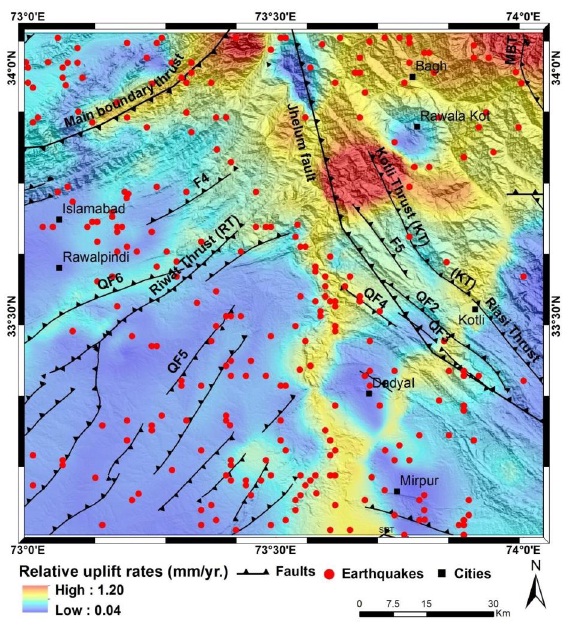
This study describes the surface deformation in lower Jehlum and eastern Potwar using remotely sensed Shutter Radar Topographic Mission (SRTM) Digital Elevation Model (DEM) to identify regional uplift rates. Mapping of active surface deformations help to predict seismic hazards. DEMs are the fundamental input factors that identify the surface geometry and its belongings. These belongings include stream offset, elevation, and slope breaks within a contributing area. This study provides an evidence of tectonic activity and its impact on regional drainage network using SRTM DEM. Various indices including concavity and steepness were computed using power law in steady state conditions. We prepared the drainage network map of the study site showing uplift rates in mm/year. The deflection in stream network proves the existence of active fault in this region which controls the local drainage network. The results prove the relative uplift along Main Boundary Thurst (MBT) and the impact of active tectonic on evolving young organs.
References
Chen, S. P., Qi, J. F., Cheng, X. S., Xu, Z. Q., Xie, C., Zhao, Y. B., & Sun, H. L. (2006). Category of fault block group in rift basin: Example from Dongpu depression. Fault-block Oil & Gas Field, Vol.13, No.3, pp. 1-5
Whipple, K.X, and Tucker, G.E., 2002, Implications of sediment-flux dependent river incision models for landscape evolution: Journal of Geophysical Research, v. 107, no. B2, 20 p., doi: 10.1029/2000JB000044
Roe, G.H., Montgomery, D.R., and Hallet, B., 2002, Effects of orographic precipitation variations on the concavity of steady-state river profiles: Geology, v. 30, p. 143–146, doi: 10.1130/0091-7613(2002)030<0143: EOOPVO>2.0.CO; 2.
Stock, J. D., and D. R. Montgomery (1999), Geologic constraints on bedrock river incision using the stream power law, J. Geophys. Res., 104, 4983 – 4993.
Duvall, A., Kirby, E., and Burbank, D.W., 2004, Tectonic and lithologic controls on channel profiles and processes in coastal California: Journal of Geophysical Research, v. 109, p. F3, doi:10.1029/2003JF000086.
Jadoon, I. A. I<, Frisch, W., Kemal, A. & Jaswal. T. M., 1997 (in press). Thrust geometries and kinematics in the Himalayan foreland (North Potwar Deformed Zone), North Pakistan Geol. Rundschau 200.
Howard, A.D., and Kerby, G., 1983, Channel changes in badlands: Geological Society of America Bulletin, v. 94, p. 739–752, doi: 10.1130/0016-7606(1983)94<739: CCIB>2.0.CO;2
Hack, J.T., 1973, Stream profile analysis and stream-gradient index: U.S. Geological Survey Journal of 195 Research, v. 1, no. 4, p. 421–429
Wobus, C., Whipple., K. Kirby, E., Snyder, N., Johnson, J., Spyropolou, K., Crosby, B. and Sheehan, D. (2006). Tectonics from topography: Procedures, promise and pitfalls. In: Willett, S.D., Hovius, N, Brandon, M.T., and Fisher, D.M., eds., Tectonics, Climate and Landscape Evolution. Geological Society of America Special Paper, 398: 55-74
Sklar, L. S., and W. E. Dietrich (2001), Sediment and rock strength controls on river incision into bedrock, Geology, 29, 1087 – 1090.

Published
How to Cite
Issue
Section
License
Copyright (c) 2020 50Sea

This work is licensed under a Creative Commons Attribution 4.0 International License.


