
Assessing the Efficacy of Pixel-based and Object-based Classification Techniques and Classifiers for Land Cover Mapping Using Landsat-8 and Sentinel-2 Data in Complex Mountainous Terrain
DOI:
https://doi.org/10.33411/IJIST/1482Keywords:
LULC, Machine Learning, OBIA vs Pixel-Based, Gilgit, GEEAbstract
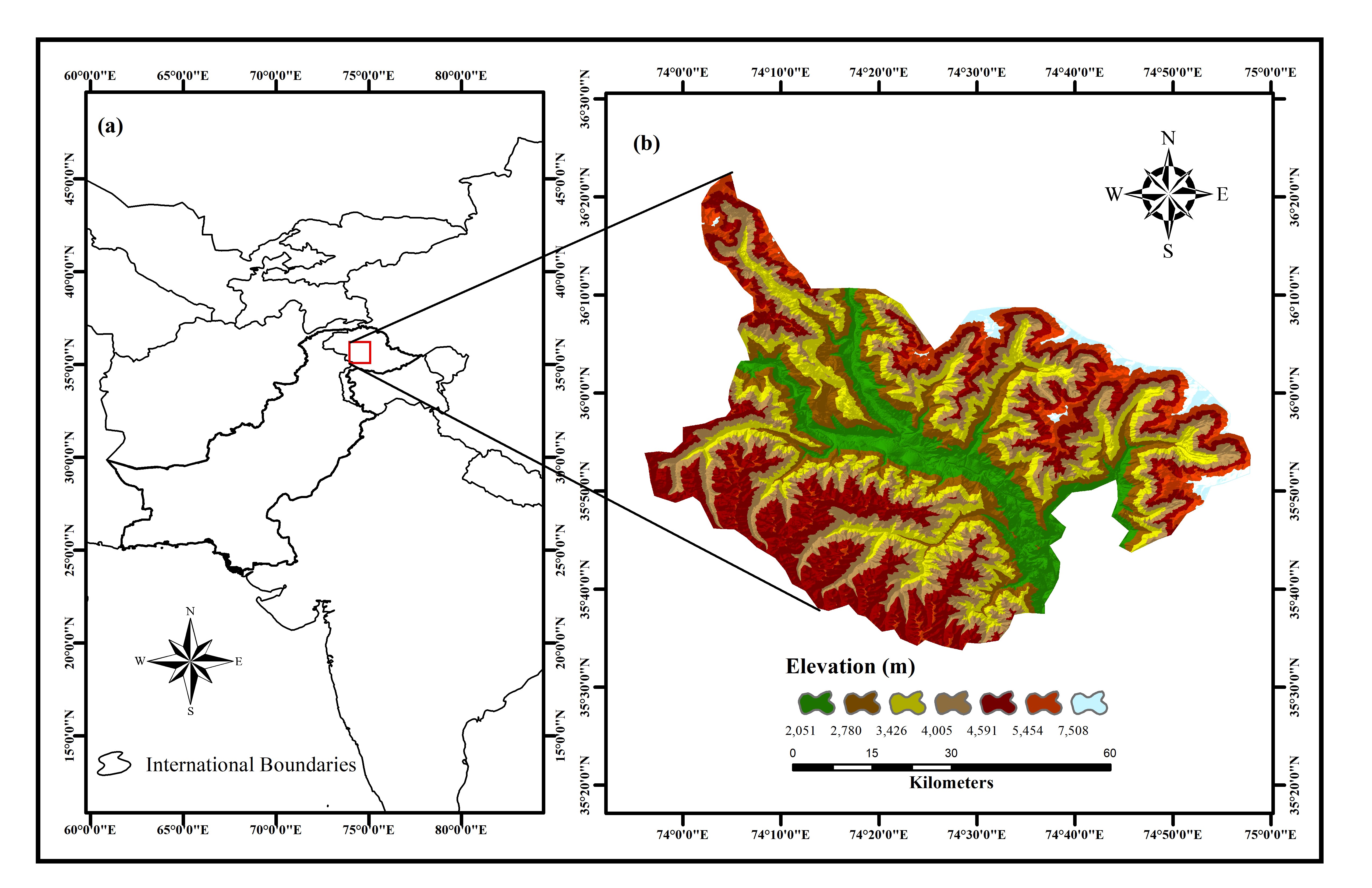
Disaster mitigation and climate-resilient planning heavily depend on accurate Land Use and Land Cover (LULC) datasets. Well-classified LULC data optimizes hazard modeling, surface runoff estimation, and sustainable land use planning, enabling informed decision-making and proactive risk reduction. However, supervised LULC classification faces challenges such as selecting optimal Machine Learning (ML) algorithms, differences in spatial and spectral resolution, and seasonal variability. This study adopts a multi-tiered approach to generate effective LULC maps for Gilgit District, Pakistan, by comparing pixel-based classification and object-based image analysis (OBIA) methods. Pixel-based classification was performed on Google Earth Engine (GEE) using Landsat-8 and Sentinel-2 imagery, applying three classifiers: Random Forest (RF), Support Vector Machine (SVM), and k-Nearest Neighbor (k-NN). OBIA involved multi-resolution segmentation, followed by training and classification on image objects using the same algorithms. Validation using independent samples revealed that object-based maps were visually smoother and more realistic. Quantitatively, pixel-based RF yielded the highest accuracy: 82.9% for Landsat-8 and 78.02% for Sentinel-2. In contrast, OBIA k-NN achieved superior accuracy: 81.3% on Landsat-8 and 83.6% on Sentinel-2. Remaining classifiers also provided nearby results in both classification methods. Lower accuracy in Sentinel-2 may be due to within-class spectral variability at 10m spatial resolution, while Landsat-8’s lower resolution (30m) reduced object-based segmentation performance, resulting in object heterogeneity and misclassification. Although pixel-based classification provided promising results, OBIA ultimately demonstrated superior overall accuracy. This study highlights the importance of resolution-context compatibility and algorithm choice in enhancing LULC classification, which is essential for reliable climate-responsive planning, disaster preparedness, and sustainable development.
References
K. S. I. M. Z. Hasan, R. S. Leya, “Comparative Assessment of Machine Learning Algorithms for Land Use and Land Cover Classification Using Multispectral Remote Sensing Image,” Khulna Univ. Stud., pp. 33–46, doi: 10.53808/kus.2022.icstem4ir.0124-se.
A. Jamali, “Evaluation and comparison of eight machine learning models in land use/land cover mapping using Landsat 8 OLI: a case study of the northern region of Iran,” SN Appl. Sci., vol. 1, no. 11, pp. 1–11, Nov. 2019, doi: 10.1007/S42452-019-1527-8/FIGURES/4.
A. N. D. & E. Z. Hamidreza Khodaei, Farzin Nasiri Saleh, “Future flood susceptibility mapping under climate and land use change,” Sci. Rep., vol. 15, no. 12394, 2025, doi: https://doi.org/10.1038/s41598-025-97008-0.
M. R. Haque, M. K. Tusar, M. A. Mou, and M. S. Rahaman, “Assessment of LULC change and its impact on Surface Runoff using SCS-CN method for Noakhali Region, Bangladesh,” Present Environ. Sustain. Dev., vol. 18, no. 1, pp. 277–292, 2024, doi: 10.47743/PESD2024181020.
S. Aldiansyah and R. A. Saputra, “COMPARISON OF MACHINE LEARNING ALGORITHMS FOR LAND USE AND LAND COVER ANALYSIS USING GOOGLE EARTH ENGINE (CASE STUDY: WANGGU WATERSHED),” Int. J. Remote Sens. Earth Sci., vol. 19, no. 2, pp. 197–210, Jan. 2023, doi: 10.30536/J.IJRESES.2022.V19.A3803.
R. Saini and S. Singh, “Land use land cover mapping and snow cover detection in Himalayan region using machine learning and multispectral Sentinel-2 satellite imagery,” Int. J. Inf. Technol., vol. 16, no. 2, pp. 675–686, Feb. 2024, doi: 10.1007/S41870-023-01673-1/METRICS.
L. Ghayour et al., “Performance evaluation of sentinel-2 and landsat 8 OLI data for land cover/use classification using a comparison between machine learning algorithms,” Remote Sens., vol. 13, no. 7, p. 1349, Apr. 2021, doi: 10.3390/RS13071349/S1.
G. H. Nitu Wu, Luís Guilherme Teixeira Crusiol, Guixiang Liu, Deji Wuyun, “Comparing Machine Learning Algorithms for Pixel/Object-Based Classifications of Semi-Arid Grassland in Northern China Using Multisource Medium Resolution Imageries,” Remote Sens, vol. 15, no. 3, p. 750, 2023, doi: https://doi.org/10.3390/rs15030750.
L. W. L. Thanh Noi Phan, Verena Kuch, “Land Cover Classification using Google Earth Engine and Random Forest Classifier—The Role of Image Composition,” Remote Sens, vol. 12, no. 15, p. 2411, 2020, doi: https://doi.org/10.3390/rs12152411.
J. S. Zhaobin Wang, Yikun Ma, Yaonan Zhang, “Review of Remote Sensing Applications in Grassland Monitoring,” Remote Sens, vol. 14, no. 12, p. 2903, 2022, doi: https://doi.org/10.3390/rs14122903.
Y. E. Ş. Mustafa Özbuldu, “Comparative analysis of different supervised methods for satellite-based land-use classification: A case study of Reyhanlı,” Mustafa Kemal Univ. J. Agric. Sci., vol. 29, no. 3, p. 12, 2024, doi: https://doi.org/10.37908/mkutbd.1485236.
N. Aggarwal, M. srivastava, and M. Dutta, “Comparative Analysis of Pixel-Based and Object-Based Classification of High Resolution Remote Sensing Images – A Review,” Int. J. Eng. Trends Technol., vol. 38, no. 1, pp. 5–11, Aug. 2016, doi: 10.14445/22315381/IJETT-V38P202.
Nishant Mehra & Janaki Ballav Swain, “Assessment of land use land cover change and its effects using artificial neural network-based cellular automation,” J. Eng. Appl. Sci., vol. 71, no. 70, 2024, doi: https://doi.org/10.1186/s44147-024-00402-0.
A. Kumar, G. Kumar, D. S. Patil, and R. Gupta, “Evaluating Machine Learning Classifiers for IRS High Resolution Satellite Images Using Object-Based and Pixel-Based Classification Techniques,” J. Indian Soc. Remote Sens., vol. 53, no. 6, pp. 1799–1818, Jun. 2025, doi: 10.1007/S12524-024-02084-W/METRICS.
H. . B. Gupta, Neha, “Object based Information Extraction from High Resolution Satellite Imagery using eCognition,” IJCSI Int. J. Comput. Sci. Issues, vol. 11, no. 3, p. 2, 2014, [Online]. Available: https://ijcsi.org/papers/IJCSI-11-3-2-139-144.pdf
M. I. S. & M. N. Gomal Amin, Iqra Imtiaz, Ehsan Haroon, Najum us Saqib, “Assessment of Machine Learning Algorithms for Land Cover Classification in a Complex Mountainous Landscape,” J. Geovisualization Spat. Anal., vol. 8, no. 34, 2024, doi: https://doi.org/10.1007/s41651-024-00195-z.
S. R. Zohaib, N. Habib, A. Talha Manzoor, S. Abbas, “Comparative Assessment of Classification Algorithms for Land Cover Mapping Using Multispectral and PCA Images of Landsat,” Int. J. Innov. Sci. Technol, vol. 6, no. 6, pp. 225–239, 2024, doi: https://journal.50sea.com/index.php/IJIST/article/view/840.
Z.-Q. S. Ling-Min He, Fan-Sheng Kong, “Multiclass SVM based land cover classification with multisource data,” IEEE Xplore, 2005, doi: 10.1109/ICMLC.2005.1527555.
G. Guo, H. Wang, D. Bell, Y. Bi, and K. Greer, “KNN Model-Based Approach in Classification,” Lect. Notes Comput. Sci. (including Subser. Lect. Notes Artif. Intell. Lect. Notes Bioinformatics), vol. 2888, pp. 986–996, 2003, doi: 10.1007/978-3-540-39964-3_62.
M. A. M. & E. G. Shahadat Uddin, Ibtisham Haque, Haohui Lu, “Comparative performance analysis of K-nearest neighbour (KNN) algorithm and its different variants for disease prediction,” Sci. Rep., vol. 12, no. 6256, 2022, doi: https://doi.org/10.1038/s41598-022-10358-x.
M. Belgiu and L. Drăgu, “Random forest in remote sensing: A review of applications and future directions,” ISPRS J. Photogramm. Remote Sens., vol. 114, pp. 24–31, Apr. 2016, doi: 10.1016/J.ISPRSJPRS.2016.01.011.
P. Thanh Noi and M. Kappas, “Comparison of Random Forest, k-Nearest Neighbor, and Support Vector Machine Classifiers for Land Cover Classification Using Sentinel-2 Imagery,” Sensors 2018, Vol. 18, Page 18, vol. 18, no. 1, p. 18, Dec. 2017, doi: 10.3390/S18010018.
Y. G. Shuai Xie, Liangyun Liu, Xiao Zhang, Jiangning Yang, Xidong Chen, “Automatic Land-Cover Mapping using Landsat Time-Series Data based on Google Earth Engine,” Remote Sens, vol. 11, no. 24, p. 3023, 2019, doi: https://doi.org/10.3390/rs11243023.
N. Gorelick, M. Hancher, M. Dixon, S. Ilyushchenko, D. Thau, and R. Moore, “Google Earth Engine: Planetary-scale geospatial analysis for everyone,” Remote Sens. Environ., vol. 202, pp. 18–27, Dec. 2017, doi: 10.1016/J.RSE.2017.06.031.
L. C. Nadeem Ullah, “Insights into climate change dynamics: A tourism climate index-based evaluation of Gilgit-Baltistan, Pakistan,” Heliyon, vol. 10, no. 15, p. e35315, 2024, [Online]. Available: https://www.cell.com/heliyon/fulltext/S2405-8440(24)11346-1?_returnURL=https%3A%2F%2Flinkinghub.elsevier.com%2Fretrieve%2Fpii%2FS2405844024113461%3Fshowall%3Dtrue
A. Q. B. Amjad Ali Khan, Xian Xue, Hassam Hussain, Kiramat Hussain, Ali Muhammad, Muhammad Ahsan Mukhtar, “Study of Land Surface Changes in Highland Environments for the Sustainable Management of the Mountainous Region in Gilgit-Baltistan, Pakistan,” Sustainability, vol. 16, no. 23, p. 10311, 2024, doi: https://doi.org/10.3390/su162310311.
“Birds of Gilgit-Baltistan - Home.” Accessed: Jul. 23, 2025. [Online]. Available: https://www.birdsofgilgit.com/index.html
“Landsat 8 | U.S. Geological Survey.” Accessed: Jul. 23, 2025. [Online]. Available: https://www.usgs.gov/landsat-missions/landsat-8
F. G. Osman Salih Yilmaz, “Chapter 9 - Investigation of surface water dynamics from the Landsat series using Google Earth Engine: A case study of Lake Bafa,” Google Earth Engine Artif. Intell. Earth Obs., pp. 177–193, 2025, doi: https://doi.org/10.1016/B978-0-443-27372-8.00013-1.
C. Martin Claverie, Junchang Ju, Jeffrey G. Masek, Jennifer L. Dungan, Eric F. Vermote, Jean-Claude Roger, Sergii V. Skakun, Justice, “The Harmonized Landsat and Sentinel-2 surface reflectance data set,” Remote Sens. Environ., vol. 219, pp. 145–161, 2018, doi: https://doi.org/10.1016/j.rse.2018.09.002.
S. A. S. Siti Aminah Anshah, Nurul Ain Nabilah Sharuddin, “Chapter 24 - Mature and immature oil palm classification from image Sentinel-2 using Google earth engine (GEE),” Google Earth Engine Artif. Intell. Earth Obs., pp. 465–487, 2025, doi: https://doi.org/10.1016/B978-0-443-27372-8.00001-5.
Sudhir K. Powar, “An Evaluation of Pixel-based and Object-based Classification Methods for Land Use Land Cover Analysis Using Geoinformatic Techniques,” Geomatics Environ. Eng., vol. 16, no. 2, p. 2, 2022, [Online]. Available: https://www.gaee.agh.edu.pl/gaee/article/view/182
H. R. El Mehdi Sellami, “A NEW APPROACH FOR MAPPING LAND USE / LAND COVER USING GOOGLE EARTH ENGINE: A COMPARISON OF COMPOSITION IMAGES,” Int. Arch. Photogramm. Remote Sens. Spat. Inf. Sci., 2023, [Online]. Available: https://isprs-archives.copernicus.org/articles/XLVIII-4-W6-2022/343/2023/
J. A. & J. C. Zhiwen Li, Xingyu Chen, Jie Qi, Chong Xu, “Accuracy assessment of land cover products in China from 2000 to 2020,” Sci. Rep., vol. 13, no. 12936, 2023, doi: https://doi.org/10.1038/s41598-023-39963-0.
M. C. Cidália C. Fonte, Diogo Duarte, Ismael Jesus, Hugo Costa, Pedro Benevides, Francisco Moreira, “Accuracy Assessment and Comparison of National, European and Global Land Use Land Cover Maps at the National Scale—Case Study: Portugal,” Remote Sens, vol. 16, no. 9, p. 1504, 2024, doi: https://doi.org/10.3390/rs16091504.
Downloads
Published
How to Cite
Issue
Section
License
Copyright (c) 2025 50sea

This work is licensed under a Creative Commons Attribution 4.0 International License.


