
Assessment of Groundwater Potential Zones Using Electrical Resistivity in Muzaffargarh
Keywords:
Electrical Resistivity Survey, Vertical Electrical Sounding, Google Earth Engine, Groundwater Potential ZoneAbstract
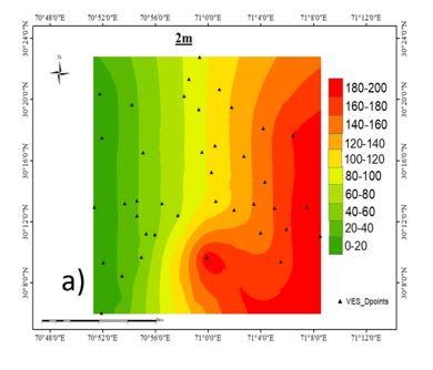
The study integrates Earth observation and geospatial data to evaluate groundwater potential and conditions in Muzaffargarh, South Punjab, Pakistan, a region grappling with freshwater scarcity due to high sediment concentrations in subsurface water. The developed approach aims to enhance sustainable water resource management in areas affected by such sediment challenges. An electrical resistivity survey was conducted at 40 locations within the study area, incorporating Vertical Electrical Sounding (VES) and spatial analysis with hydrogeological parameters to analyze and visualize the spatial distribution of freshwater. A weighted overlay analysis was employed to map freshwater and saline water zones, supported by 2D resistivity maps. The study generated several thematic layers, including data on geology, rainfall, lineaments, land use/land cover (LULC), drainage density, soil type, and slope. A groundwater potential (GWP) zone map was created, categorizing the area into four zones: very good, good, moderate, and poor. Additionally, resistivity maps were produced at depths of 2m, 10m, 50m, 80m, 200m, and 300m to analyze resistivity variations in the Ghazi Ghat and Qasba Gujrat areas of Muzaffargarh district. The study's findings include curves indicating potential groundwater zones and a comprehensive understanding of subsurface characteristics through resistivity curve comparisons. These results provide valuable insights for the sustainable management of groundwater resources in the region, particularly in addressing freshwater scarcity.
References
M. Hasan, Y. Shang, P. Shao, X. Yi, and H. Meng, “Evaluation of Engineering Rock Mass Quality via Integration Between Geophysical and Rock Mechanical Parameters,” Rock Mech. Rock Eng., vol. 55, no. 4, pp. 2183–2203, Apr. 2022, doi: 10.1007/S00603-021-02766-8/METRICS.
N. A. Bowling, “Is the job satisfaction–job performance relationship spurious? A meta-analytic examination,” J. Vocat. Behav., vol. 71, no. 2, pp. 167–185, Oct. 2007, doi: 10.1016/J.JVB.2007.04.007.
K. Rasool, M. Helal, A. Ali, C. E. Ren, Y. Gogotsi, and K. A. Mahmoud, “Antibacterial Activity of Ti3C2Tx MXene,” ACS Nano, vol. 10, no. 3, pp. 3674–3684, Mar. 2016, doi: 10.1021/ACSNANO.6B00181/ASSET/IMAGES/NN-2016-00181G_M002.GIF.
K. Indhulekha, K. C. Mondal, and D. C. Jhariya, “Groundwater prospect mapping using remote sensing, GIS and resistivity survey techniques in Chhokra Nala Raipur district, Chhattisgarh, India,” J. Water Supply Res. Technol., vol. 68, no. 7, pp. 595–606, Nov. 2019, doi: 10.2166/AQUA.2019.159.
S. Muhammad, M. I. Ehsan, and P. Khalid, “Optimizing exploration of quality groundwater through geophysical investigations in district Pakpattan, Punjab, Pakistan,” Arab. J. Geosci. 2022 158, vol. 15, no. 8, pp. 1–15, Apr. 2022, doi: 10.1007/S12517-022-09990-8.
P. Anbazhagan, M. Sreenivas, B. Ketan, S. S. R. Moustafa, and N. S. N. Al-Arifi, “Selection of Ground Motion Prediction Equations for Seismic Hazard Analysis of Peninsular India,” J. Earthq. Eng., vol. 20, no. 5, pp. 699–737, Jul. 2016, doi: 10.1080/13632469.2015.1104747.
K. Pratap, K. V. Ravindran, and B. Prabakaran, “Groundwater prospect zoning using remote sensing and geographical information system: A case study in Dala-Renukoot area, Sonbhadra district, Uttar Pradesh,” J. Indian Soc. Remote Sens., vol. 28, no. 4, pp. 249–263, 2000, doi: 10.1007/BF02990815/METRICS.
R. K. Prasad, N. C. Mondal, P. Banerjee, M. V. Nandakumar, and V. S. Singh, “Deciphering potential groundwater zone in hard rock through the application of GIS,” Environ. Geol., vol. 55, no. 3, pp. 467–475, Aug. 2008, doi: 10.1007/S00254-007-0992-3/METRICS.
B. Deepika, K. Avinash, and K. S. Jayappa, “Integration of hydrological factors and demarcation of groundwater prospect zones: Insights from remote sensing and GIS techniques,” Environ. Earth Sci., vol. 70, no. 3, pp. 1319–1338, Oct. 2013, doi: 10.1007/S12665-013-2218-1/METRICS.
K. C. Ng et al., “Experimental investigation of the silica gel–water adsorption isotherm characteristics,” Appl. Therm. Eng., vol. 21, no. 16, pp. 1631–1642, Nov. 2001, doi: 10.1016/S1359-4311(01)00039-4.
S. Ali, D. Li, F. Congbin, and F. Khan, “Twenty first century climatic and hydrological changes over Upper Indus Basin of Himalayan region of Pakistan,” Environ. Res. Lett., vol. 10, no. 1, p. 014007, Jan. 2015, doi: 10.1088/1748-9326/10/1/014007.
M. T. Chan, A. Selvam, and J. W. C. Wong, “Reducing nitrogen loss and salinity during ‘struvite’ food waste composting by zeolite amendment,” Bioresour. Technol., vol. 200, pp. 838–844, Jan. 2016, doi: 10.1016/J.BIORTECH.2015.10.093.
J. S. Singh, S. Koushal, A. Kumar, S. R. Vimal, and V. K. Gupta, “Book Review: Microbial Inoculants in Sustainable Agricultural Productivity- Vol. II: Functional Application,” Front. Microbiol., vol. 7, p. 232116, Dec. 2016, doi: 10.3389/FMICB.2016.02105.
B. K. Allam, N. Musa, A. Debnath, U. L. Usman, and S. Banerjee, “Recent developments and application of bimetallic based materials in water purification,” Environ. Challenges, vol. 5, p. 100405, Dec. 2021, doi: 10.1016/J.ENVC.2021.100405.
S. Niwas and O. A. L. De Lima, “Aquifer Parameter Estimation from Surface Resistivity Data,” Groundwater, vol. 41, no. 1, pp. 94–99, Jan. 2003, doi: 10.1111/J.1745-6584.2003.TB02572.X.
P. D. Sreedevi, K. Subrahmanyam, and S. Ahmed, “The significance of morphometric analysis for obtaining groundwater potential zones in a structurally controlled terrain,” Environ. Geol., vol. 47, no. 3, pp. 412–420, Feb. 2005, doi: 10.1007/S00254-004-1166-1/METRICS.
S. Y. ©1 and K. Elangovan, “Groundwater potential zones delineation using geo-electrical resistivity method and GIS for Coimbatore, India,” IJMS Vol.47(05) [May 2018], vol. 47, no. 05, pp. 1088–1095, 2018, Accessed: Jun. 15, 2024. [Online]. Available: http://nopr.niscpr.res.in/handle/123456789/44408
M. A. Hagras and A. F. Agamy, “The effect of downstream perforated blanket on the safety against piping in heading-up structures,” Ain Shams Eng. J., vol. 5, no. 1, pp. 41–47, Mar. 2014, doi: 10.1016/J.ASEJ.2013.07.008.
D. W. Greenman, W. V. Swarzenski, and G. D. Bennett, “Ground-water hydrology of the Punjab region of West Pakistan, with emphasis on problems caused by canal irrigation,” Water Supply Pap., 1967, doi: 10.3133/WSP1608H.
P. W. Swarzenski, C. D. Reich, R. M. Spechler, J. L. Kindinger, and W. S. Moore, “Using multiple geochemical tracers to characterize the hydrogeology of the submarine spring off Crescent Beach, Florida,” Chem. Geol., vol. 179, no. 1–4, pp. 187–202, Sep. 2001, doi: 10.1016/S0009-2541(01)00322-9.
R. T. Nickson, J. M. McArthur, B. Shrestha, T. O. Kyaw-Myint, and D. Lowry, “Arsenic and other drinking water quality issues, Muzaffargarh District, Pakistan,” Appl. Geochemistry, vol. 20, no. 1, pp. 55–68, Jan. 2005, doi: 10.1016/J.APGEOCHEM.2004.06.004.
M. S. E. Juanah, S. Ibrahim, W. N. A. Sulaiman, and P. A. Latif, “Groundwater resources assessment using integrated geophysical techniques in the southwestern region of Peninsular Malaysia,” Arab. J. Geosci., vol. 6, no. 11, pp. 4129–4144, Nov. 2013, doi: 10.1007/S12517-012-0700-9/METRICS.
A. Maqsoom et al., “Landslide susceptibility mapping along the China Pakistan Economic Corridor (CPEC) route using multi-criteria decision-making method,” Model. Earth Syst. Environ., vol. 8, no. 2, pp. 1519–1533, Jun. 2022, doi: 10.1007/S40808-021-01226-0/METRICS.
T. Melese and T. Belay, “Groundwater Potential Zone Mapping Using Analytical Hierarchy Process and GIS in Muga Watershed, Abay Basin, Ethiopia,” Glob. Challenges, vol. 6, no. 1, p. 2100068, Jan. 2022, doi: 10.1002/GCH2.202100068.
K. Ashwini, R. K. Verma, S. Sriharsha, S. Chourasiya, and A. Singh, “Delineation of groundwater potential zone for sustainable water resources management using remote sensing-GIS and analytic hierarchy approach in the state of Jharkhand, India,” Groundw. Sustain. Dev., vol. 21, p. 100908, May 2023, doi: 10.1016/J.GSD.2023.100908.
M. Rajesh, E. Kavaz, and D. P. R. B., “Photoluminescence, radiative shielding properties of Sm3+ ions doped fluoroborosilicate glasses for visible (reddish-orange) display and radiation shielding applications,” Mater. Res. Bull., vol. 142, p. 111383, Oct. 2021, doi: 10.1016/J.MATERRESBULL.2021.111383.
Downloads
Published
How to Cite
Issue
Section
License
Copyright (c) 2024 50SEA

This work is licensed under a Creative Commons Attribution 4.0 International License.


