
Rock Fall Hazard and Risk Assessment using GIS Along Jaglot-Skardu Road, Pakistan
Keywords:
GIS, Karakoram Highway (KKH), Remote Sensing, Susceptibility, Rock fall inventoryAbstract
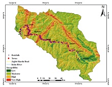
Rockfall is one of the major hazards all around the world. In Northern Pakistan, Jaglot-Skardu. The road is the main highway that connects KKH and Skardu, located in Gilgit Baltistan. The Area is very unique to study rock falls because of the variety of changes in the geological, seismological, and atmospheric conditions. The hazard and risk mapping of rock falls includes preparation of rock fall inventory map, susceptibility map and spatial analysis of Rock fall with its conditioning factors using GIS and Remote Sensing. The inventory map includes record of past rock falls along the road and prepared on hill shade map of the area using ArcGIS 10.4. Susceptibility maps of the area is generated using Weighted overlay technique. In Weighted overlay technique we use multi influencing factors of the rock falls as such as aspect, geology, slope, elevation, faults, curvature, Topographic wetness index, streams and road. Each map unit is than reclassified and assigned weight in weighted overlay to generate susceptibility map of area. In inventory map, almost 200 rock falls are marked and delineated on hill shade map of the area. The results of susceptibility show four zones i.e., low, moderate, high and very high hazard zones.The spatial analysis of rock falls showed that fault and geology is the main factor that are triggering the rock falls in the area. The areas which are present low and moderate susceptible zones are somehow safe and suitable for future planning and development and areas present in high to very high susceptible zones, large scale geotechnical investigations are required before any development and construction.
References
D. J. Varnes, “Slope movement types and processes,” Spec. Rep., vol. 176, pp. 11–33, 1978.
C. Chalkias, M. Ferentinou, and C. Polykretis, “GIS-Based Landslide Susceptibility Mapping on the Peloponnese Peninsula, Greece,” Geosci. 2014, Vol. 4, Pages 176-190, vol. 4, no. 3, pp. 176–190, Aug. 2014, doi: 10.3390/GEOSCIENCES4030176.
P. Budetta, “Assessment of rockfall risk along roads,” Nat. Hazards Earth Syst. Sci., vol. 4, no. 1, pp. 71–81, Mar. 2004, doi: 10.5194/NHESS-4-71-2004.
F. Nadim, O. Kjekstad, P. Peduzzi, C. Herold, and C. Jaedicke, “Global landslide and avalanche hotspots,” Landslides, vol. 3, no. 2, pp. 159–173, May 2006, doi: 10.1007/S10346-006-0036-1/METRICS.
W. Ho, “Integrated analytic hierarchy process and its applications–A literature review,” Eur. J. Oper. Res., vol. 186, no. 1, pp. 211–228, 2008.
U. Kamp, B. J. Growley, G. A. Khattak, and L. A. Owen, “GIS-based landslide susceptibility mapping for the 2005 Kashmir earthquake region,” Geomorphology, vol. 101, no. 4, pp. 631–642, Nov. 2008, doi: 10.1016/J.GEOMORPH.2008.03.003.
M. Calvello, M. N. Papa, J. Pratschke, and M. Nacchia Crescenzo, “Landslide risk perception: a case study in Southern Italy,” Landslides, vol. 13, no. 2, pp. 349–360, Apr. 2016, doi: 10.1007/S10346-015-0572-7/METRICS.
N. Matsuoka and H. Sakai, “Rockfall activity from an alpine cliff during thawing periods,” Geomorphology, vol. 28, no. 3–4, pp. 309–328, Jul. 1999, doi: 10.1016/S0169-555X(98)00116-0.
S. Ahmed, S. H. Solangi, M. Saeed Khan Jadoon, and A. Nazeer, “Tectonic evolution of structures in Southern Sindh Monocline, Indus Basin, Pakistan formed in multi-extensional tectonic episodes of Indian Plate,” Geod. Geodyn., vol. 9, no. 5, pp. 358–366, Sep. 2018, doi: 10.1016/J.GEOG.2018.03.004.
S. Ali, R. Haider, W. Abbas, M. Basharat, and K. Reicherter, “Empirical assessment of rockfall and debris flow risk along the Karakoram Highway, Pakistan,” Nat. Hazards, vol. 106, no. 3, pp. 2437–2460, Apr. 2021, doi: 10.1007/S11069-021-04549-4/TABLES/4.
S. Ali, P. Biermanns, R. Haider, and K. Reicherter, “LANDSLIDE SUSCEPTIBILITY MAPPING BY USING GIS ALONG THE CHINA PAKISTAN ECONOMIC CORRIDOR (KARAKORAM HIGHWAY), PAKISTAN”, doi: 10.5194/nhess-2018-39.
M. Basharat, H. R. Shah, and N. Hameed, “Landslide susceptibility mapping using GIS and weighted overlay method: a case study from NW Himalayas, Pakistan,” Arab. J. Geosci., vol. 9, no. 4, pp. 1–19, Apr. 2016, doi: 10.1007/S12517-016-2308-Y/METRICS.
S. Javed, “Landslide hazard mapping of Bagh district in Azad Kashmir,” Int. J. Econ. Environ. Geol., pp. 47–50, 2019.
A. S. Bacha, M. Shafique, and H. van der Werff, “Landslide inventory and susceptibility modelling using geospatial tools, in Hunza-Nagar valley, northern Pakistan,” J. Mt. Sci., vol. 15, no. 6, pp. 1354–1370, 2018, doi: 10.1007/s11629-017-4697-0.
J. F. Dewey and S. H. Lamb, “Active tectonics of the Andes,” Tectonophysics, vol. 205, no. 1–3, pp. 79–95, Apr. 1992, doi: 10.1016/0040-1951(92)90419-7.
M. F. Ahmed, J. D. Rogers, and E. H. Ismail, “Historic Landslide Dams along the Upper Indus River, Northern Pakistan,” Nat. Hazards Rev., vol. 16, no. 3, p. 04014029, Nov. 2014, doi: 10.1061/(ASCE)NH.1527-6996.0000165.
H. T. Rib, T. Liang, R. L. Schuster, and R. J. Krizek, “Landslides: Analysis and control,” Recognit. Identif., pp. 34–80, 1978.
H. Fujisada, M. Urai, and A. Iwasaki, “Technical methodology for ASTER global DEM,” IEEE Trans. Geosci. Remote Sens., vol. 50, no. 10, pp. 3725–3736, 2012.
C. Chalkias, M. Ferentinou, and C. Polykretis, “GIS supported landslide susceptibility modeling at regional scale: An expert-based fuzzy weighting method,” ISPRS Int. J. Geo-Information, vol. 3, no. 2, pp. 523–539, 2014.
M. F. Ahmed, J. D. Rogers, and E. H. Ismail, “A regional level preliminary landslide susceptibility study of the upper Indus river basin,” Eur. J. Remote Sens., vol. 47, no. 1, pp. 343–373, 2014.
L. Ayalew, H. Yamagishi, H. Marui, and T. Kanno, “Landslides in Sado Island of Japan: Part II. GIS-based susceptibility mapping with comparisons of results from two methods and verifications,” Eng. Geol., vol. 81, no. 4, pp. 432–445, Nov. 2005, doi: 10.1016/J.ENGGEO.2005.08.004.
P. Tarolli, M. Borga, K.-T. Chang, and S.-H. Chiang, “Modeling shallow landsliding susceptibility by incorporating heavy rainfall statistical properties,” Geomorphology, vol. 133, no. 3–4, pp. 199–211, 2011.
A. Rashid, Aspect-oriented database systems. Springer Science & Business Media, 2004.
A. Yalcin, “GIS-based landslide susceptibility mapping using analytical hierarchy process and bivariate statistics in Ardesen (Turkey): Comparisons of results and confirmations,” CATENA, vol. 72, no. 1, pp. 1–12, Jan. 2008, doi: 10.1016/J.CATENA.2007.01.003.
“Comparison the AHP and FUZZY-AHP Decision Making Methods in Underground DAM Site Selection in Taleghan Basin.” https://www.researchgate.net/publication/275637280_Comparison_the_AHP_and_FUZZY-AHP_Decision_Making_Methods_in_Underground_DAM_Site_Selection_in_Taleghan_Basin (accessed Sep. 19, 2023).
S. Peruccacci, M. T. Brunetti, S. Luciani, C. Vennari, and F. Guzzetti, “Lithological and seasonal control on rainfall thresholds for the possible initiation of landslides in central Italy,” Geomorphology, vol. 139–140, pp. 79–90, Feb. 2012, doi: 10.1016/J.GEOMORPH.2011.10.005.
K. J. Beven and M. J. Kirkby, “A physically based, variable contributing area model of basin hydrology/Un modèle à base physique de zone d’appel variable de l’hydrologie du bassin versant,” Hydrol. Sci. J., vol. 24, no. 1, pp. 43–69, 1979.
H. Hong et al., “Landslide susceptibility assessment in the Anfu County, China: comparing different statistical and probabilistic models considering the new topo-hydrological factor (HAND),” Earth Sci. Informatics, vol. 11, no. 4, pp. 605–622, Dec. 2018, doi: 10.1007/S12145-018-0352-8/METRICS.
C. Xu, X. Xu, F. Dai, J. Xiao, X. Tan, and R. Yuan, “Landslide hazard mapping using GIS and weight of evidence model in Qingshui River watershed of 2008 Wenchuan earthquake struck region,” J. Earth Sci., vol. 23, no. 1, pp. 97–120, Feb. 2012, doi: 10.1007/S12583-012-0236-7/METRICS.
A. M. Youssef, M. Al-Kathery, and B. Pradhan, “Landslide susceptibility mapping at Al-Hasher area, Jizan (Saudi Arabia) using GIS-based frequency ratio and index of entropy models,” Geosci. J., vol. 19, no. 1, pp. 113–134, Mar. 2015, doi: 10.1007/S12303-014-0032-8/METRICS.
B. Pradhan, “A comparative study on the predictive ability of the decision tree, support vector machine and neuro-fuzzy models in landslide susceptibility mapping using GIS,” Comput. Geosci., vol. 51, pp. 350–365, Feb. 2013, doi: 10.1016/J.CAGEO.2012.08.023.
“(PDF) Landslide hazard assessment using analytic hierarchy processing (AHP) and geographic information system in Kaligesing mountain area of Central Java Province Indonesia.” https://www.researchgate.net/publication/303582492_Landslide_hazard_assessment_using_analytic_hierarchy_processing_AHP_and_geographic_information_system_in_Kaligesing_mountain_area_of_Central_Java_Province_Indonesia (accessed Sep. 19, 2023).
M. Cardinali et al., “A geomorphological approach to the estimation of landslide hazards and risks in Umbria, Central Italy,” Nat. Hazards Earth Syst. Sci., vol. 2, no. 1/2, pp. 57–72, Jun. 2002, doi: 10.5194/NHESS-2-57-2002.
T. L. Saaty, “How to make a decision: The analytic hierarchy process,” Eur. J. Oper. Res., vol. 48, no. 1, pp. 9–26, Sep. 1990, doi: 10.1016/0377-2217(90)90057-I.
J. D. Rogers, “Report accompanying map of landslides and other surficial deposits of the City of Orinda,” CA Rogers/Pacific, Inc. City Orinda Public Work. Dep, 1994.
Published
How to Cite
Issue
Section
License
Copyright (c) 2023 50SEA

This work is licensed under a Creative Commons Attribution 4.0 International License.


