
Spatial Investigation of Soil Erosion Risk in the High Rainfall Zone of Pakistan by Using Rusle Model
Keywords:
Geospatial Analysis, Remote Sensing, Revised Universal Soil Loss Equation (RUSLE), Soil Erosion, Landsat.Abstract
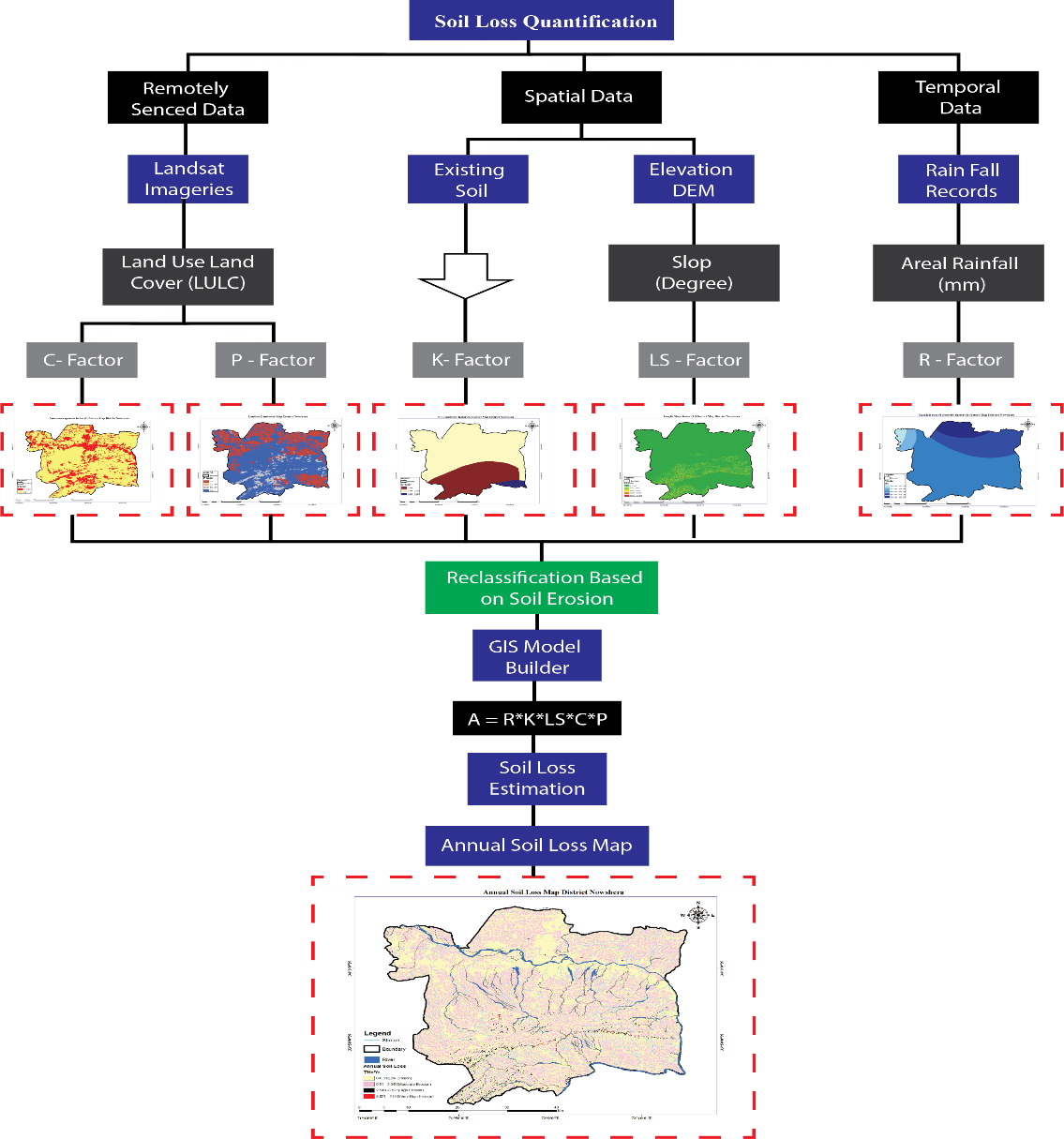
The degradation of soil quality and agricultural sustainability is threatened by soil erosion, which poses a serious threat to livelihoods and food security. Maintaining soil fertility and reducing the danger of erosion require efficient evaluation and management strategies. This research presents an innovative approach to assessing soil erosion in Nowshera District, leveraging remote sensing technology coupled with Geographic Information System (GIS) tools. The study intends to offer a more thorough and accurate understanding of erosion patterns and drivers in the area by incorporating these cutting-edge approaches. Cloud-free LANDSAT 8 multispectral images, characterized by minimal vegetation cover, serve as the primary dataset for this analysis. The integration of the RUSLE model with GIS and remote sensing techniques enables the calculation of soil erosion rates throughout the research region. The study demonstrates variation in soil erosion parameters across different locations, as indicated by the range of R factor values, which range from 603.43 to 696.43 MJ mm/ha/h/year. The southeastern portion demonstrates significantly lower erosion rates than the northwestern part, which can be linked to variations in topography and land use patterns. This study highlights the significance of using remote sensing techniques to evaluate soil erosion changes over time and provide valuable information for land management plans in Nowshera District, Pakistan. This information may be used to make better decisions regarding conservation planning and agricultural sustainability.
References
Q. Ulain, S. M. Ali, A. A. Shah, K. M. J. Iqbal, W. Ullah, and M. A. U. R. Tariq, “Identification of Soil Erosion-Based Degraded Land Areas by Employing a Geographic Information System—A Case Study of Pakistan for 1990–2020,” Sustain. 2022, Vol. 14, Page 11888, vol. 14, no. 19, p. 11888, Sep. 2022, doi: 10.3390/SU141911888.
D. Mandal, M. Chandrakala, N. M. Alam, T. Roy, and U. Mandal, “Assessment of soil quality and productivity in different phases of soil erosion with the focus on land degradation neutrality in tropical humid region of India,” CATENA, vol. 204, p. 105440, Sep. 2021, doi: 10.1016/J.CATENA.2021.105440.
S. Siddiqui, M. W. A. Safi, A. Tariq, N. U. Rehman, and S. W. Haider, “GIS Based Universal Soil Erosion Estimation in District Chakwal Punjab, Pakistan,” Int. J. Econ. Environ. Geol., vol. 11, no. 2, pp. 30–36, Sep. 2020, doi: 10.46660/IJEEG.VOL11.ISS2.2020.443.
J. Poesen, “Soil erosion in the Anthropocene: Research needs,” Earth Surf. Process. Landforms, vol. 43, no. 1, pp. 64–84, Jan. 2018, doi: 10.1002/ESP.4250.
K. T. Osman, “Soil Erosion by Water,” Soil Degrad. Conserv. Remediat., pp. 69–101, 2014, doi: 10.1007/978-94-007-7590-9_3.
P. A. Ochoa, A. Fries, D. Mejía, J. I. Burneo, J. D. Ruíz-Sinoga, and A. Cerdà, “Effects of climate, land cover and topography on soil erosion risk in a semiarid basin of the Andes,” CATENA, vol. 140, pp. 31–42, May 2016, doi: 10.1016/J.CATENA.2016.01.011.
N. A. S. Bashir, A. Javed, I. Bibi, “Soil and water conservation," Pakistan,” Univ. Agric. Faisalabad, pp. 263–286, 2017.
J. Zhou et al., “The long-term uncertainty of biodegradable mulch film residues and associated microplastics pollution on plant-soil health,” J. Hazard. Mater., vol. 442, p. 130055, Jan. 2023, doi: 10.1016/J.JHAZMAT.2022.130055.
B. Yadav et al., “Modeling and Assessment of Land Degradation Vulnerability in Arid Ecosystem of Rajasthan Using Analytical Hierarchy Process and Geospatial Techniques,” L. 2023, Vol. 12, Page 106, vol. 12, no. 1, p. 106, Dec. 2022, doi: 10.3390/LAND12010106.
M. R. Rahman, Z. H. Shi, and C. Chongfa, “Soil erosion hazard evaluation—An integrated use of remote sensing, GIS and statistical approaches with biophysical parameters towards management strategies,” Ecol. Modell., vol. 220, no. 13–14, pp. 1724–1734, Jul. 2009, doi: 10.1016/J.ECOLMODEL.2009.04.004.
A. R. Vaezi, M. Ahmadi, and A. Cerdà, “Contribution of raindrop impact to the change of soil physical properties and water erosion under semi-arid rainfalls,” Sci. Total Environ., vol. 583, pp. 382–392, Apr. 2017, doi: 10.1016/J.SCITOTENV.2017.01.078.
F. Sajedi-Hosseini, B. Choubin, K. Solaimani, A. Cerdà, and A. Kavian, “Spatial prediction of soil erosion susceptibility using a fuzzy analytical network process: Application of the fuzzy decision making trial and evaluation laboratory approach,” L. Degrad. Dev., vol. 29, no. 9, pp. 3092–3103, Sep. 2018, doi: 10.1002/LDR.3058.
D. D. Alexakis, E. Tapoglou, A. E. K. Vozinaki, and I. K. Tsanis, “Integrated Use of Satellite Remote Sensing, Artificial Neural Networks, Field Spectroscopy, and GIS in Estimating Crucial Soil Parameters in Terms of Soil Erosion,” Remote Sens. 2019, Vol. 11, Page 1106, vol. 11, no. 9, p. 1106, May 2019, doi: 10.3390/RS11091106.
I. Gitas, K. Douros, C. Minakou, G. N. Silleos, and C. Karydas, “Multi-temporal soil erosion risk assessment in N. Chalkidiki using a modified USLE raster model.,” 2009.
S. Kumar et al., “Estimation of soil erosion in indo-gangetic region using revised universal soil loss equation (RUSLE) model and geospatial technology,” Model. Earth Syst. Environ., vol. 9, no. 1, pp. 1251–1273, Mar. 2023, doi: 10.1007/S40808-022-01553-W/METRICS.
“Predicting rainfall erosion losses: a guide to conservation planning.” Accessed: May 21, 2024. [Online]. Available: https://www3.epa.gov/npdes/pubs/ruslech2.pdf
S. Ullah, A. Ali, M. Iqbal, M. Javid, and M. Imran, “Geospatial assessment of soil erosion intensity and sediment yield: a case study of Potohar Region, Pakistan,” Environ. Earth Sci., vol. 77, no. 19, pp. 1–13, Oct. 2018, doi: 10.1007/S12665-018-7867-7/METRICS.
M. Wynants, H. Solomon, P. Ndakidemi, and W. H. Blake, “Pinpointing areas of increased soil erosion risk following land cover change in the Lake Manyara catchment, Tanzania,” Int. J. Appl. Earth Obs. Geoinf., vol. 71, pp. 1–8, Sep. 2018, doi: 10.1016/J.JAG.2018.05.008.
E. Z. Nyakatawa, K. C. Reddy, and J. L. Lemunyon, “Predicting soil erosion in conservation tillage cotton production systems using the revised universal soil loss equation (RUSLE),” Soil Tillage Res., vol. 57, no. 4, pp. 213–224, Jan. 2001, doi: 10.1016/S0167-1987(00)00178-1.
E. Burnett, B. A. Stewart, and A. L. Black, “Regional Effects of Soil Erosion on Crop Productivity—Great Plains,” Soil Eros. Crop Product., pp. 285–304, Jan. 2015, doi: 10.2134/1985.SOILEROSIONANDCROP.C17.
E. H. Erdogan, G. Erpul, and I. Bayramin, “Use of USLE/GIS methodology for predicting soil loss in a semiarid agricultural watershed,” Environ. Monit. Assess., vol. 131, no. 1–3, pp. 153–161, Aug. 2007, doi: 10.1007/S10661-006-9464-6/METRICS.
M. Hrabalíková and M. Janeček, “Comparison of different approaches to LS factor calculations based on a measured soil loss under simulated rainfall.,” https://swr.agriculturejournals.cz/doi/10.17221/222/2015-SWR.html, vol. 12, no. 2, pp. 69–77, 2017, doi: 10.17221/222/2015-SWR.
F. Mushtaq and M. G. N. Lala, “Assessment of hydrological response as a function of LULC change and climatic variability in the catchment of the Wular Lake, J&K, using geospatial technique,” Environ. Earth Sci., vol. 76, no. 22, pp. 1–19, Nov. 2017, doi: 10.1007/S12665-017-7065-Z/METRICS.
J. M. van der Knijff, J. Younis, and A. P. J. de Roo, “LISFLOOD: a GIS‐based distributed model for river basin scale water balance and flood simulation,” Int. J. Geogr. Inf. Sci., vol. 24, no. 2, pp. 189–212, Feb. 2010, doi: 10.1080/13658810802549154.
A. Ashraf, “Risk modeling of soil erosion under different land use and rainfall conditions in Soan river basin, sub-Himalayan region and mitigation options,” Model. Earth Syst. Environ., vol. 6, no. 1, pp. 417–428, Mar. 2020, doi: 10.1007/S40808-019-00689-6/METRICS.
A. Maqsoom et al., “Geospatial Assessment of Soil Erosion Intensity and Sediment Yield Using the Revised Universal Soil Loss Equation (RUSLE) Model,” ISPRS Int. J. Geo-Information 2020, Vol. 9, Page 356, vol. 9, no. 6, p. 356, May 2020, doi: 10.3390/IJGI9060356.
V. J. Markose and K. S. Jayappa, “Soil loss estimation and prioritization of sub-watersheds of Kali River basin, Karnataka, India, using RUSLE and GIS,” Environ. Monit. Assess., vol. 188, no. 4, pp. 1–16, Apr. 2016, doi: 10.1007/S10661-016-5218-2/METRICS.
J. Thomas, S. Joseph, and K. P. Thrivikramji, “Assessment of soil erosion in a tropical mountain river basin of the southern Western Ghats, India using RUSLE and GIS,” Geosci. Front., vol. 9, no. 3, pp. 893–906, May 2018, doi: 10.1016/J.GSF.2017.05.011.
M. Zerihun, M. S. Mohammedyasin, D. Sewnet, A. A. Adem, and M. Lakew, “Assessment of soil erosion using RUSLE, GIS and remote sensing in NW Ethiopia,” Geoderma Reg., vol. 12, pp. 83–90, Mar. 2018, doi: 10.1016/J.GEODRS.2018.01.002.
P. Ochoa-Cueva, A. Fries, P. Montesinos, J. A. Rodríguez-Díaz, and J. Boll, “Spatial Estimation of Soil Erosion Risk by Land-cover Change in the Andes OF Southern Ecuador,” L. Degrad. Dev., vol. 26, no. 6, pp. 565–573, Aug. 2015, doi: 10.1002/LDR.2219.
M. Wagari and H. Tamiru, “RUSLE Model Based Annual Soil Loss Quantification for Soil Erosion Protection: A Case of Fincha Catchment, Ethiopia,” Air, Soil Water Res., vol. 14, Oct. 2021, doi: 10.1177/11786221211046234/ASSET/IMAGES/LARGE/10.1177_11786221211046234-FIG10.JPEG.
V. Prasannakumar, H. Vijith, S. Abinod, and N. Geetha, “Estimation of soil erosion risk within a small mountainous sub-watershed in Kerala, India, using Revised Universal Soil Loss Equation (RUSLE) and geo-information technology,” Geosci. Front., vol. 3, no. 2, pp. 209–215, Mar. 2012, doi: 10.1016/J.GSF.2011.11.003.
T. S. Abdulkadir et al., “Quantitative analysis of soil erosion causative factors for susceptibility assessment in a complex watershed,” Cogent Eng., vol. 6, no. 1, Jan. 2019, doi: 10.1080/23311916.2019.1594506.
R. Chakrabortty, B. Pradhan, P. Mondal, and S. C. Pal, “The use of RUSLE and GCMs to predict potential soil erosion associated with climate change in a monsoon-dominated region of eastern India,” Arab. J. Geosci., vol. 13, no. 20, pp. 1–20, Oct. 2020, doi: 10.1007/S12517-020-06033-Y/METRICS.
“Modeling soil erosion processes in watersheds and the relation between soil loss with geomorphic and chemical parameters – Fingerprint — King Fahd University of Petroleum & Minerals.” Accessed: May 21, 2024. [Online]. Available: https://pure.kfupm.edu.sa/en/publications/modeling-soil-erosion-processes-in-watersheds-and-the-relation-be-2/fingerprints/
T. G. Pham, J. Degener, and M. Kappas, “Integrated universal soil loss equation (USLE) and Geographical Information System (GIS) for soil erosion estimation in A Sap basin: Central Vietnam,” Int. Soil Water Conserv. Res., vol. 6, no. 2, pp. 99–110, Jun. 2018, doi: 10.1016/J.ISWCR.2018.01.001.
P. Thapa, “Spatial Estimation of Soil Erosion Using RUSLE Modeling: A case study of Dolakha District, Nepal,” Jul. 2020, doi: 10.21203/RS.3.RS-25478/V4.
S. C. Pal and R. Chakrabortty, “Modeling of water induced surface soil erosion and the potential risk zone prediction in a sub-tropical watershed of Eastern India,” Model. Earth Syst. Environ., vol. 5, no. 2, pp. 369–393, Jun. 2019, doi: 10.1007/S40808-018-0540-Z/METRICS.
G. Thakuriah, “Correction to: GIS-based revised universal soil loss equation for estimating annual soil erosion: a case of lower Kulsi basin, India (SN Applied Sciences, (2023), 5, 3, (81), 10.1007/s42452-023-05303-0),” SN Appl. Sci., vol. 5, no. 4, pp. 1–1, Apr. 2023, doi: 10.1007/S42452-023-05317-8/METRICS.
M. B. Baig, S. A. Shahid, and G. S. Straquadine, “Making rainfed agriculture sustainable through environmental friendly technologies in Pakistan: A review,” Int. Soil Water Conserv. Res., vol. 1, no. 2, pp. 36–52, Sep. 2013, doi: 10.1016/S2095-6339(15)30038-1.
A. Khan, A. U. Rahman, and S. Mahmood, “Spatial estimation of soil erosion risk using RUSLE model in District Swat, Eastern Hindu Kush, Pakistan,” J. Water Clim. Chang., vol. 14, no. 6, pp. 1881–1899, Jun. 2023, doi: 10.2166/WCC.2023.495/1246359/JWC0141881.PDF.
M. Irshad, J. Ali, Faridullah, and A. Egrinya Eneji, “Chemical properties of soil and runoff water under different land uses in Abbottabad, Pakistan,” Environ. Earth Sci., vol. 74, no. 4, pp. 3501–3506, Aug. 2015, doi: 10.1007/S12665-015-4386-7/METRICS.
Downloads
Published
How to Cite
Issue
Section
License
Copyright (c) 2024 50SEA

This work is licensed under a Creative Commons Attribution 4.0 International License.


