
Assessing Urban Expansion and Land Cover Change in City District Lahore using Multi-Stage Satellite Data
Lahore land use land cover
DOI:
https://doi.org/10.33411/IJIST/1508Keywords:
Change Detection, Confusion Matrix, LULC Modeling, GIS, Remote SensingAbstract
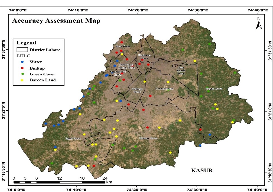
Lahore, a metropolis and 2nd second-largest city of Pakistan, has been experiencing rapid urban expansion over the past five decades. The socio-economic development and growth of the urban population have caused the rapid increase of urban expansion. The increase in the built-up area of Lahore has seen remarkable growth during the past decades. This study is aimed at detecting the Spatio-temporal changes in land use and land cover and evaluating the urban expansion of Lahore since 2003. The conversion of land to other uses is primarily because of growth in urban population, whereas the increase in economic activities is the central reason for the land-use changes. In this study, temporal Landsat imageries were used. The supervised image classification of the maximum likelihood algorithm was applied on Landsat ETM+ (2003) and OLI/TIRs (2023) images, whereas a post-classification comparison technique was employed to detect changes over time. The spatial and temporal analysis revealed that during the past twenty decades, the built-up area of Lahore city has expanded by 486 km². It was found from the analysis that in Lahore city, the urban expansion was primarily at the cost of loss of fertile agricultural land, vegetation, and other cultivable land use. The analysis further revealed that The Total agricultural area in 2003 was 725 KM². The agricultural land to Built-up area is about 325 km². Due to the population increasing, the newly added population needs more space to fulfill their basic needs. The Total Barren Land in 2003 was 7452 KM².The Barren land to Built-up color, which is about 255 km².Rapid Land use changes have been marked for a period of 20 years in Lahore. The increase in the area used for built-up land is 470 Km² in 2003 to 956 Km² in 2023 (overall increase is 28 %), respectively.
References
M. Matsa, O. Mupepi, T. Musasa, and R. Defe, “A GIS and remote sensing aided assessment of land use/cover changes in resettlement areas; a case of ward 32 of Mazowe district, Zimbabwe,” J. Environ. Manage., vol. 276, p. 111312, 2020, doi: https://doi.org/10.1016/j.jenvman.2020.111312.
A. B. Mamadou Traore, Mai Son Lee, Azad Rasul, “Assessment of land use/land cover changes and their impacts on land surface temperature in Bangui (the capital of Central African Republic),” Environ. Challenges, vol. 4, p. 100114, 2021, doi: https://doi.org/10.1016/j.envc.2021.100114.
B. M. G. Sonam Wangyel Wang, “Land Use and Land Cover Change Detection and Prediction in the Kathmandu District of Nepal Using Remote Sensing and GIS,” Sustainability, vol. 12, no. 9, p. 3925, 2020, doi: https://doi.org/10.3390/su12093925.
E. M. Attua and and J. B. Fisher, “Historical and Future Land-Cover Change in a Municipality of Ghana,” Earth Interact., vol. 15, no. 9, p. 2, 2011, [Online]. Available: https://journals.ametsoc.org/view/journals/eint/15/9/2010ei304.1.xml
D. Lu, P. Mausel, E. Brondízio, and E. Moran, “Change detection techniques,” Int. J. Remote Sens., vol. 25, no. 12, pp. 2365–2401, Jun. 2004, doi: 10.1080/0143116031000139863.
J. Cheng and I. Masser, “Urban growth pattern modeling: a case study of Wuhan city, PR China,” Landsc. Urban Plan., vol. 62, no. 4, 2003, doi: https://doi.org/10.1016/S0169-2046(02)00150-0.
M. A. K. Sher Muhammad Malik, Muhammad Usman Khan, Muhammad Miandad, “Spatio-temporal Valuation of Urban Expansion and Landuse Changes in Bahawalpur,” Pakistan Geogr. Rev., vol. 74, no. 2, pp. 127–141, 2019, [Online]. Available: https://pu.edu.pk/images/journal/geography/pdf/4_V74_No2_2019.pdf
M. K. J.S. Rawat, “Monitoring land use/cover change using remote sensing and GIS techniques: A case study of Hawalbagh block, district Almora, Uttarakhand, India,” Egypt. J. Remote Sens. Sp. Sci., vol. 18, no. 1, pp. 77–84, 2015, doi: https://doi.org/10.1016/j.ejrs.2015.02.002.
H. G. Coskun, U. Alganci, and G. Usta, “Analysis of land use change and urbanization in the Kucukcekmece Water basin (Istanbul, Turkey) with temporal satellite data using remote sensing and GIS,” Sensors, vol. 8, no. 11, pp. 7213–7223, Nov. 2008, doi: 10.3390/S8117213.
M. Hasan, L. Hassan, M. A. Al, M. H. Abualreesh, M. H. Idris, and A. H. M. Kamal, “Urban green space mediates spatiotemporal variation in land surface temperature: a case study of an urbanized city, Bangladesh,” Environ. Sci. Pollut. Res., vol. 29, no. 24, pp. 36376–36391, May 2022, doi: 10.1007/S11356-021-17480-9/METRICS.
J. P. Tarulata Shapla, “Agricultural Land Cover Change in Gazipur, Bangladesh, in Relation to Local Economy Studied Using Landsat Images,” Adv. Remote Sensing, vol. 4, no. 3, 2015, [Online]. Available: https://www.scirp.org/journal/paperinformation?paperid=58994
C. N. Mundia and M. Aniya, “Analysis of land use/cover changes and urban expansion of Nairobi city using remote sensing and GIS,” Int. J. Remote Sens., vol. 26, no. 13, pp. 2831–2849, Jul. 2005, doi: 10.1080/01431160500117865;JOURNAL:JOURNAL:TRES20.
Z. H. Jieying Xiao, Yanjun Shen, Jingfeng Ge, Ryutaro Tateishi, Changyuan Tang, Yanqing Liang, “Evaluating urban expansion and land use change in Shijiazhuang, China, by using GIS and remote sensing,” Landsc. Urban Plan., vol. 75, no. 1–2, pp. 69–80, 2006, doi: https://doi.org/10.1016/j.landurbplan.2004.12.005.
B. Y. Nnyaladzi Batisani, “Urban expansion in Centre County, Pennsylvania: Spatial dynamics and landscape transformations,” Appl. Geogr., vol. 29, no. 2, pp. 235–249, 2009, doi: https://doi.org/10.1016/j.apgeog.2008.08.007.
M. K. J.S. Rawat, Vivekanand Biswas, “Changes in land use/cover using geospatial techniques: A case study of Ramnagar town area, district Nainital, Uttarakhand, India,” Egypt. J. Remote Sens. Sp. Sci., vol. 16, no. 1, pp. 111–117, 2013, doi: https://doi.org/10.1016/j.ejrs.2013.04.002.
R. S. Kumiko Fujita, Gulsan Ara Parvin, “4 - Social background in char areas, Bangladesh: Implication for Japanese hazard mapping technology,” Sci. Technol. Disaster Risk Reduct. Asia, pp. 39–55, 2018, doi: https://doi.org/10.1016/B978-0-12-812711-7.00004-3.
“Remote Sensing and Image Interpretation, 7th Edition | Wiley.” Accessed: Jun. 24, 2024. [Online]. Available: https://www.wiley.com/en-sg/Remote+Sensing+and+Image+Interpretation%2C+7th+Edition-p-9781118343289
M. Z. Iqbal and M. J. Iqbal, “Land Use Detection Using Remote Sensing and GIS (A Case Study of Rawalpindi Division),” Am. J. Remote Sens. 2018, Vol. 6, Page 39, vol. 6, no. 1, pp. 39–51, Apr. 2018, doi: 10.11648/J.AJRS.20180601.17.
P. K. Srivastava, D. Han, M. A. Rico-Ramirez, M. Bray, and T. Islam, “Selection of classification techniques for land use/land cover change investigation,” Adv. Sp. Res., vol. 50, no. 9, pp. 1250–1265, Nov. 2012, doi: 10.1016/J.ASR.2012.06.032.
K. S. Lakshmi N. Kantakumar a, Shamita Kumar, “Spatiotemporal urban expansion in Pune metropolis, India using remote sensing,” Habitat Int., vol. 51, pp. 11–22, 2016, doi: https://doi.org/10.1016/j.habitatint.2015.10.007.
Z. Sun, R. Ma, and Y. Wang, “Using Landsat data to determine land use changes in Datong basin, China,” Environ. Geol., vol. 57, no. 8, pp. 1825–1837, Jun. 2009, doi: 10.1007/S00254-008-1470-2/METRICS.
Giles M. Foody, “Status of land cover classification accuracy assessment,” Remote Sens. Environ., vol. 80, no. 1, pp. 185–201, 2002, doi: https://doi.org/10.1016/S0034-4257(01)00295-4.
Z. ur Rahman et al., “Faecal and nitrate contamination in the groundwater of Mardan district, Pakistan,” Environ. Geochem. Health, vol. 43, no. 9, pp. 3615–3624, Sep. 2021, doi: 10.1007/S10653-021-00848-8/METRICS.
B. K. Goksel et al., “Abducens nerve palsy and optic neuritis as initial manifestation in brucellosis,” Scand. J. Infect. Dis., vol. 38, no. 8, pp. 721–725, Aug. 2006, doi: 10.1080/00365540500466614,.
Muhammad Nasar-u-Minallah, “Retrieval of Land Surface Temperature of Lahore Through Landsat-8 TIRS Data,” Int. J. Econ. Environ. Geol., vol. 10, no. 1, pp. 70–77, 2019, doi: 10.46660/ijeeg.Vol10.Iss1.2019.220.
K. Mehmood, Saifullah, M. Iqbal, Z. Rengel, and M. M. Abrar, “Pakistan and India Collaboration to Improve Regional Air Quality Has Never Been More Promising,” Integr. Environ. Assess. Manag., vol. 16, no. 5, pp. 549–551, Sep. 2020, doi: 10.1002/IEAM.4292;CTYPE:STRING:JOURNAL.
C.-W. C. Y.-J. Su, K.-C. Kuo, T.-W. Wang, “Gender-based differences in COVID-19,” New Microbes New Infect., vol. 42, p. 100905, 2021, doi: https://doi.org/10.1016/j.nmni.2021.100905.
M. Bokaie, M. Simbar, S. Ardekani, and H. Majd, “Women’s beliefs about infertility and sexual behaviors: A qualitative study,” Iran. J. Nurs. Midwifery Res., vol. 21, no. 4, p. 379, Jul. 2016, doi: 10.4103/1735-9066.185579.
J. Z. Talha Hassan, “Surface Urban Heat Islands Dynamics in Response to LULC and Vegetation across South Asia (2000–2019),” Remote Sens, vol. 13, no. 16, p. 3177, 2021, doi: https://doi.org/10.3390/rs13163177.
Y. M. Manjula Ranagalage, “The Impacts of Landscape Changes on Annual Mean Land Surface Temperature in the Tropical Mountain City of Sri Lanka: A Case Study of Nuwara Eliya (1996–2017),” Sustainability, vol. 11, no. 19, p. 5517, 2019, doi: https://doi.org/10.3390/su11195517.
M. Imran and A. Mehmood, “Analysis and mapping of present and future drivers of local urban climate using remote sensing: a case of Lahore, Pakistan,” Arab. J. Geosci. 2020 136, vol. 13, no. 6, pp. 1–14, Mar. 2020, doi: 10.1007/S12517-020-5214-2.
Downloads
Published
How to Cite
Issue
Section
License
Copyright (c) 2025 50sea

This work is licensed under a Creative Commons Attribution 4.0 International License.


