
Floods and Flood Hazard Assessment in the Floodplain of River Swat, District Charsadda, Pakistan
DOI:
https://doi.org/10.33411/IJIST/1513Keywords:
Floods, Flood Hazard Assessment, Flood Hazard Zonation, GIS, AHP, MappingAbstract
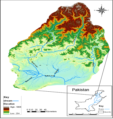
This study aims to evaluate flood risks and carry out flood hazard assessment in the floodplain of the River Swat, District Charsadda. This study focuses on two objectives: primarily, to explore the flood situation in the study area, and secondly, to carry out the flood hazard assessment in the floodplain of the River Swat, District Charsadda. The study area is located 27 km north-east of Peshawar city. District Charsadda is part of the Peshawar valley, and the study area covers an area of 1,593 Km2. The gentle slope is from north to south, which plays a major role in making it vulnerable to recurrent flood events. In District Charsadda, the floodplain of the River Swat is highly vulnerable to recurrent flooding during the summer season. There is a lack of flood hazard assessment for management strategies. Therefore, to minimize the negative impacts of floods, flood hazard assessment and management strategies will help reduce the losses resulting from recurrent flooding. There is a need to identify the flood hazard trend in the study area and to generate the flood hazard zonation map. The data are collected from PMD, PIDA, WAPDA, and the Survey of Pakistan. A SPOT recent 2.5m resolution satellite image is used for land use data, and the SRTM data of 90m resolution is used for the generation of a contour map, DEM, and drainage pattern. From the collected data, a hydrograph is created and projected, and the frequency of flood recurrence is determined. To obtain a good picture of the occurrence of floods, the data were also connected with temperature and rainfall characteristics. The AHP method is used to develop a flood hazard zonation map, for which the probability and recurrent intervals of the flood hazard are calculated by using the 24-year data from 1998-2022, and graphed. This clearly shows the recurrence of the flood hazard with specific magnitudes. The physical parameters, including the discharge, amount of rainfall, and elevation data, are used to develop a flood hazard zonation map under a combination of five zones.
References
A. ur Rahman, A. N. Khan, and A. E. Collins, “Analysis of landslide causes and associated damages in the Kashmir Himalayas of Pakistan,” Nat. Hazards, vol. 71, no. 1, pp. 803–821, Nov. 2014, doi: 10.1007/S11069-013-0918-1/METRICS.
H. Wheater, S. Sorooshian, and K. D. Sharma, “Hydrological Modelling in Arid and Semi-Arid Areas,” Hydrol. Model. Arid Semi-Arid Areas, vol. 9780521869188, pp. 1–212, Jan. 2007, doi: 10.1017/CBO9780511535734.
Stanley A. Changnon, “The 1993 Flood’s Aftermath: Risks, Root Causes, and Lessons for the Future,” J. Contemp. Water Res. Educ., vol. 130, 2005, [Online]. Available: https://onlinelibrary.wiley.com/doi/abs/10.1111/j.1936-704X.2005.mp130001012.x
M.-W. R. 22. Shepherd A, Mitchell T, Lewis K, Lenhardt A, Jones L, Scott L, “The Geography of poverty, disasters and climate extremes in 2030,” Shap. policy Dev. Overseas Dev. Institute, UK, 2013, [Online]. Available: https://library.wmo.int/records/item/52827-the-geography-of-poverty-disasters-and-climate-extremes-in-2030?offset=63
Atta-Ur Rahman, “Disaster risk management: flood perspective,” VDM Verlag, Ger., 2010, [Online]. Available: https://www.researchgate.net/publication/258345283_Disaster_Risk_Management_Flood_Perspective
B. Khan and M. J. Iqbal, “Forecasting flood risk in the Indus River system using hydrological parameters and its damage assessment,” Arab. J. Geosci., vol. 6, no. 10, pp. 4069–4078, Oct. 2013, doi: 10.1007/S12517-012-0665-8/METRICS.
G. O. PAKISTAN, “National Disaster Risk Reduction Policy 2013,” Minist. Clim. Chang., 2013, [Online]. Available: https://knowledge.unv.org/sites/default/files/2022-05/National DRR policy Pakistan.pdf
M. Diakakis, S. Mavroulis, and G. Deligiannakis, “Floods in Greece, a statistical and spatial approach,” Nat. Hazards, vol. 62, no. 2, pp. 485–500, Jun. 2012, doi: 10.1007/S11069-012-0090-Z/METRICS.
F. K. Tawatchai Tingsanchali, “Flood-hazard assessment and risk-based zoning of a tropical flood plain: case study of the Yom River, Thailand,” Hydrol. Sci. J., vol. 55, no. 2, pp. 145–161, 2010, [Online]. Available: https://www.tandfonline.com/doi/full/10.1080/02626660903545987
V. Chhotray and Roger Few, “Post-disaster recovery and ongoing vulnerability: Ten years after the super-cyclone of 1999 in Orissa, India,” Glob. Environ. Chang., vol. 22, no. 3, pp. 695–702, 2012, doi: https://doi.org/10.1016/j.gloenvcha.2012.05.001.
J. S.-G. Belmonte, Ana M. Camarasa, María J. López-García, “Mapping temporally-variable exposure to flooding in small Mediterranean basins using land-use indicators,” Appl. Geogr., vol. 31, no. 1, pp. 136–145, 2011, doi: https://doi.org/10.1016/j.apgeog.2010.03.003.
Muhammad Awais Hussain, Zhang Shuai, Muhammad Aamir Moawwez, Tariq Umar, Muhammad Rashid Iqbal, “A Review of Spatial Variations of Multiple Natural Hazards and Risk Management Strategies in Pakistan,” Water, vol. 15, no. 3, p. 407, 2023, doi: https://doi.org/10.3390/w15030407.
Ali A, “Indus Basin Floods: Mechanisms, Impacts, and Management,” Asian Dev. Bank, 6 ADB Ave. Mandaluyong City 1550 Metro Manila, Philipp., Oct. 2013, doi: 10.22/JS/JQUERY.DATATABLES.MIN.JS.
B. Nadeem, A. Rahman, and M. Dawood, “MODELLING RAINFALL VARIABILITY, TREND AND ANOMALY IN JHELUM RIVER BASIN, WESTERN HIMALAYA,” Carpathian J. Earth Environ. Sci., vol. 20, no. 2, pp. 295–306, 2025, doi: 10.26471/CJEES/2025/020/334.
M. Pant, R. Bhatla, S. Ghosh, S. Das, and R. K. Mall, “How climate change is affecting the summer monsoon extreme rainfall pattern over the Indo-Gangetic Plains of India: present and future perspectives,” Clim. Dyn., vol. 62, no. 2, pp. 1055–1075, Feb. 2024, doi: 10.1007/S00382-023-06953-X/METRICS.
A. F. V. L. Marlies H. Barendrecht, Alessia Matanó, Heidi Mendoza, Ruben Weesie, Melanie Rohse, Johanna Koehler, Marleen de Ruiter, Margaret Garcia, Maurizio Mazzoleni, Jeroen C. J. H. Aerts, Philip J. Ward, Giuliano Di Baldassarre, Rosie Day, “Exploring drought-to-flood interactions and dynamics: A global case review,” Wires Water, 2024, doi: https://doi.org/10.1002/wat2.1726.
R. A. F. & M. B. Davor Kvočka, “Flood hazard assessment for extreme flood events,” Nat. Hazards, vol. 84, pp. 1569–1599, 2016, [Online]. Available: https://link.springer.com/article/10.1007/s11069-016-2501-z
S. A. Amirhossein Shadmehri Toosi, Shahab Doulabian, Erfan Ghasemi Tousi, Giancarlo Humberto Calbimonte, “Large-scale flood hazard assessment under climate change: A case study,” Ecol. Eng., vol. 147, p. 105765, 2020, doi: https://doi.org/10.1016/j.ecoleng.2020.105765 Get rights and content.
M. U. Loan T.K. Ho, “Micro-landform classification and flood hazard assessment of the Thu Bon alluvial plain, central Vietnam via an integrated method utilizing remotely sensed data,” Appl. Geogr., vol. 31, no. 3, pp. 1082–1093, 2011, doi: https://doi.org/10.1016/j.apgeog.2011.01.005.
J. Birkmann and U. University, “Measuring vulnerability to natural hazards :: towards disaster resilient societies /: edited by Jörn Birkmann,” United Nation Digit. Libr., 2006, Accessed: Aug. 05, 2025. [Online]. Available: https://digitallibrary.un.org/record/587074
Atta-ur-Rahman and A. N. Khan, “Analysis of flood causes and associated socio-economic damages in the Hindukush region,” Nat. Hazards, vol. 59, no. 3, pp. 1239–1260, Dec. 2011, doi: 10.1007/S11069-011-9830-8/METRICS.
Downloads
Published
How to Cite
Issue
Section
License
Copyright (c) 2025 50sea

This work is licensed under a Creative Commons Attribution 4.0 International License.


