Evaluating and Predicting the Land Use Land Cover Changes and its Impact on Land Surface Temperature using CA-Markov model: A study of District Mardan, Pakistan
Keywords:
LULC, GIS, Land Surface Temperature, Urban Expansion, CA-Markov Chain AnalysisAbstract
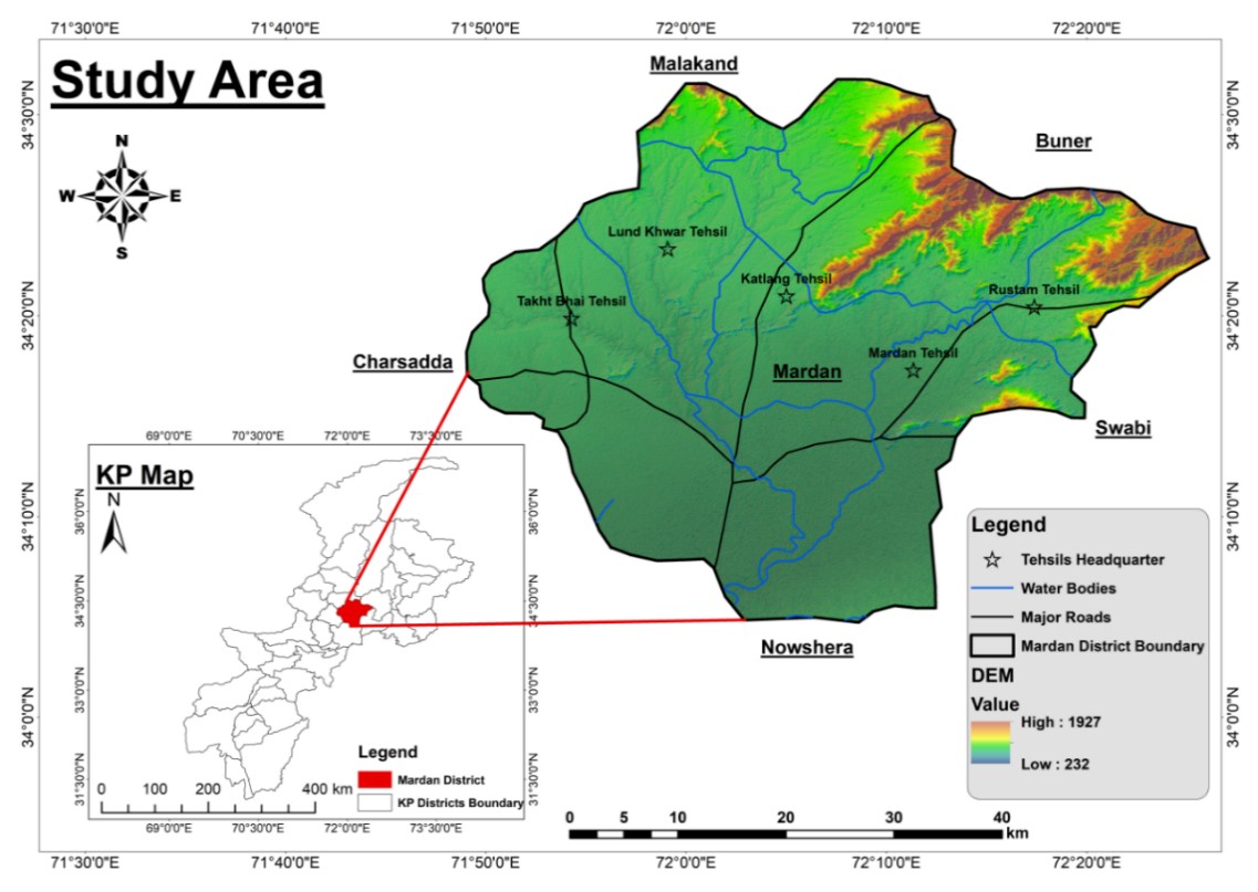
The Rapid population growth is a global phenomenon that reshapes landscapes and impacts environmental conditions. This study aims to analyze the effects of urbanization on Land Use Land Cover (LULC) changes and their impact on Land Surface Temperature (LST) in District Mardan from 2002 to 2022, while also predicting future LULC and LST changes for the year 2042. Utilizing remotely sensed data and Geographic Information Systems (GIS), the study evaluates the correlation between the conversion of natural landscapes to built-up areas and the resulting changes in LST. The primary objectives are to investigate LULC changes over the past two decades, examine how these changes influence LST, and forecast future LULC and LST trends using the CA-Markov model in IDRISI SILVA software for 2042. The analysis of LULC changes from 2002 to 2022 reveals a significant increase in built-up areas and a decrease in vegetation. Built-up land expanded from 10.10% in 2002 to 16.28% in 2022, representing a 6% increase, while vegetation cover decreased by nearly 10% of the total land cover. Concurrently, LST data show that areas experiencing high temperatures have increased since 2002. In 2002, 37% of the total area had temperatures below 30°C, whereas this figure dropped to 28% by 2022. Correlation between LULC and LST indicates that barren surfaces and built-up regions experience higher temperatures, while areas with vegetation and water exhibit lower and more moderate temperatures. The CA-Markov model forecasts that built-up land will increase by 19% by 2042, continuing the current trend, while vegetation areas are expected to decrease by an additional 4% from their 2022 levels. The LST analysis suggests a further increase in high-temperature areas, with a predicted 3% decrease in low-temperature regions. This research highlights the historical trajectory of urbanization and its thermal effects in District Mardan, providing critical insights for sustainable land-use planning and strategies to mitigate urban heat island effects in the coming decades.
References
S. Liu et al., “Understanding Land use/Land cover dynamics and impacts of human activities in the Mekong Delta over the last 40 years,” Glob. Ecol. Conserv., vol. 22, p. e00991, Jun. 2020, doi: 10.1016/J.GECCO.2020.E00991.
M. M. H. Seyam, M. R. Haque, and M. M. Rahman, “Identifying the land use land cover (LULC) changes using remote sensing and GIS approach: A case study at Bhaluka in Mymensingh, Bangladesh,” Case Stud. Chem. Environ. Eng., vol. 7, p. 100293, Jun. 2023, doi: 10.1016/J.CSCEE.2022.100293.
E. F. Lambin and H. Geist, Eds., “Land-Use and Land-Cover Change,” 2006, doi: 10.1007/3-540-32202-7.
“(PDF) Land use/land cover change detection and prediction using the CA-Markov model: A case study of Quetta city, Pakistan.” Accessed: Jun. 22, 2024. [Online]. Available: https://www.researchgate.net/publication/355209516_Land_useland_cover_change_detection_and_prediction_using_the_CA-Markov_model_A_case_study_of_Quetta_city_Pakistan
“Urban Climate | Journal | ScienceDirect.com by Elsevier.” Accessed: Jun. 22, 2024. [Online]. Available: https://www.sciencedirect.com/journal/urban-climate
“Temporal March of the Chicago Heat Island in: Journal of Applied Meteorology and Climatology Volume 24 Issue 6 (1985).” Accessed: Jun. 22, 2024. [Online]. Available: https://journals.ametsoc.org/view/journals/apme/24/6/1520-0450_1985_024_0547_tmotch_2_0_co_2.xml
X. L. Chen, H. M. Zhao, P. X. Li, and Z. Y. Yin, “Remote sensing image-based analysis of the relationship between urban heat island and land use/cover changes,” Remote Sens. Environ., vol. 104, no. 2, pp. 133–146, Sep. 2006, doi: 10.1016/J.RSE.2005.11.016.
R. Wang, H. Hou, Y. Murayama, and A. Derdouri, “Spatiotemporal Analysis of Land Use/Cover Patterns and Their Relationship with Land Surface Temperature in Nanjing, China,” Remote Sens. 2020, Vol. 12, Page 440, vol. 12, no. 3, p. 440, Jan. 2020, doi: 10.3390/RS12030440.
P. Ghosh et al., “Application of Cellular automata and Markov-chain model in geospatial environmental modeling- A review,” Remote Sens. Appl. Soc. Environ., vol. 5, pp. 64–77, 2017, doi: 10.1016/j.rsase.2017.01.005.
B. Nath, Z. Wang, Y. Ge, K. Islam, R. P. Singh, and Z. Niu, “Land Use and Land Cover Change Modeling and Future Potential Landscape Risk Assessment Using Markov-CA Model and Analytical Hierarchy Process,” ISPRS Int. J. Geo-Information 2020, Vol. 9, Page 134, vol. 9, no. 2, p. 134, Feb. 2020, doi: 10.3390/IJGI9020134.
D. J. Guan, H. F. Li, T. Inohae, W. Su, T. Nagaie, and K. Hokao, “Modeling urban land use change by the integration of cellular automaton and Markov model,” Ecol. Modell., vol. 222, no. 20–22, pp. 3761–3772, Oct. 2011, doi: 10.1016/J.ECOLMODEL.2011.09.009.
X. Yang, X. Q. Zheng, and L. N. Lv, “A spatiotemporal model of land use change based on ant colony optimization, Markov chain and cellular automata,” Ecol. Modell., vol. 233, pp. 11–19, May 2012, doi: 10.1016/J.ECOLMODEL.2012.03.011.
J. Huang, Y. Wu, T. Gao, Y. Zhan, and W. Cui, “An Integrated Approach based on Markov Chain and Cellular Automata to Simulation of Urban Land Use Changes,” Appl. Math. Inf. Sci, vol. 9, no. 2, pp. 769–775, 2015, doi: 10.12785/amis/090225.
F. Fan, Y. Wang, and Z. Wang, “Temporal and spatial change detecting (1998-2003) and predicting of land use and land cover in Core corridor of Pearl River Delta (China) by using TM and ETM+ images,” Environ. Monit. Assess., vol. 137, no. 1–3, pp. 127–147, Jun. 2008, doi: 10.1007/S10661-007-9734-Y/METRICS.

Downloads
Published
How to Cite
Issue
Section
License
Copyright (c) 2024 50SEA

This work is licensed under a Creative Commons Attribution 4.0 International License.


