
Quantifying the Impact of Chashma Right Bank Irrigation Project on the Land use Dynamics and Cropping Pattern of Arid Region, Pakistan
Keywords:
CRBIP, GIS, Spatio-Temporal, Land Use, Crop ProductionAbstract
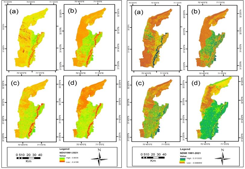
This research is focused on evaluating the impact of Chashma Right Bank Irrigation Project (CRBIP) on the land use dynamics and cropping pattern of arid region in Pakistan. Work on CRB irrigation project (CRBCIP) was started in 1984 and was subsequently completed in three stages during 2003. The CRBC holds 250,000 acres of land in the provinces of Khyber Pakhtunkhwa and Punjab. Its ultimately goal was to enhance agricultural productivity and employment opportunity. Remote sensing and GIS techniques have also been shown to be useful tools for analyzing geographical and temporal changes in land use dynamics. In order to achieve the study objectives, data were collected from both primary and secondary sources. The methodology adopted mostly based on satellite image analysis were obtained for the years 1991 to 2021. Landsat 5 (TM) images for the years 1991, 2011, Landsat 7 (Enhance Thematic Mapper) for 2001 and Landsat 8 (Operational Land Imager/ Thermal Infrared Sensor) for 2021 were acquired from USGS Earth Explorer (open source). However, the crop production data were obtained from the statics wing agriculture department. The result clearly shows that during the last three decades, the vegetation cover has increased 8.8%, built-up area in 15% while a decrease of 24% in barren land, and -0.14 % in water bodies. Significant variation in term of changes in vegetation cover in term of space and time. The found that after the CRBC area under the irrigation has gradually increased. The analysis revealed that advent of CRBC, acreage of both Kharif and Rabi crops have improved considerably. The results of this study can provide detailed information for land-use planners, researchers, policy-decision makers, and municipal authorities.
References
J. Liu et al., “Water conservancy projects in China: achievements, challenges and way forward,” Glob. Environ. Chang. Policy Dimens, vol. 23, no. 3, pp. 633–643, Jun. 2013, doi: 10.1016/j.gloenvcha.2013.02.002.
N. Khan, R. L. Ray, G. R. Sargani, M. Ihtisham, M. Khayyam, and S. Ismail, “Current Progress and Future Prospects of Agriculture Technology: Gateway to Sustainable Agriculture,” Sustain. 2021, Vol. 13, Page 4883, vol. 13, no. 9, p. 4883, Apr. 2021, doi: 10.3390/SU13094883.
A. Singh, “Poor quality water utilization for agricultural production: An environmental perspective,” Land use policy, vol. 43, pp. 259–262, Feb. 2015, doi: 10.1016/J.LANDUSEPOL.2014.11.015.
S. S. Shah, M. N. Shaikh, M. Y. Khan, M. A. Alfasane, M. M. Rahman, and M. A. Aziz, “Present Status and Future Prospects of Jute in Nanotechnology: A Review,” Chem. Rec., vol. 21, no. 7, pp. 1631–1665, Jul. 2021, doi: 10.1002/TCR.202100135.
L. Xu, H. Yang, and M. Ling, “Interpersonal contextual influences on the relationship between values and pro-environmental behaviors,” Sustain. Prod. Consum., vol. 32, pp. 532–540, Jul. 2022, doi: 10.1016/J.SPC.2022.05.012.
S. D. Vibhute, A. Sarangi, D. K. Singh, K. K. Bandhyopadhyay, S. S. Parihar, and D. Kumar, “Comparative evaluation of water budgeting parameters under different rice (Oryza sativa L.) cultivation methods,” J. Appl. Nat. Sci., vol. 9, no. 3, pp. 1373–1380, Sep. 2017, doi: 10.31018/JANS.V9I3.1370.
P. Saccon, “Water for agriculture, irrigation management,” Appl. Soil Ecol., vol. 123, pp. 793–796, Feb. 2018, doi: 10.1016/J.APSOIL.2017.10.037.
M. M. Khan et al., “Towards Sustainable Application of Wastewater in Agriculture: A Review on Reusability and Risk Assessment,” Agron. 2022, Vol. 12, Page 1397, vol. 12, no. 6, p. 1397, Jun. 2022, doi: 10.3390/AGRONOMY12061397.
S. R. Evett et al., “Past, Present, and Future of Irrigation on the U.S. Great Plains,” Trans. ASABE, vol. 63, no. 3, pp. 703–729, 2020, doi: 10.13031/TRANS.13620.
K. Kadiresan and P. R. Khanal, “Rethinking Irrigation for Global Food Security,” Irrig. Drain., vol. 67, no. 1, pp. 8–11, Feb. 2018, doi: 10.1002/IRD.2219.
M. R. Jalilvand, L. Nasrolahi Vosta, R. Khalilakbar, J. Khazaei Pool, and R. A. Tabaeeian, “The Effects of Internal Marketing and Entrepreneurial Orientation on Innovation in Family Businesses,” J. Knowl. Econ., vol. 10, no. 3, pp. 1064–1079, Sep. 2019, doi: 10.1007/S13132-017-0516-7/METRICS.
“A Study of Irrigation Intensity of Different Sources in Malshiras Tahsil.” Accessed: Jun. 24, 2024. [Online]. Available: https://www.researchgate.net/publication/331453799_A_Study_of_Irrigation_Intensity_of_Different_Sources_in_Malshiras_Tahsil
A. W. Siyal, P. W. Gerbens-Leenes, and S. Nonhebel, “Energy and carbon footprints for irrigation water in the lower Indus basin in Pakistan, comparing water supply by gravity fed canal networks and groundwater pumping,” J. Clean. Prod., vol. 286, p. 125489, Mar. 2021, doi: 10.1016/J.JCLEPRO.2020.125489.
Z. Raza, “The expected values of arithmetic bond connectivity and geometric indices in random phenylene chains,” Heliyon, vol. 6, no. 7, p. e04479, Jul. 2020, doi: 10.1016/j.heliyon.2020.e04479.
“Spatio-temporal distribution of actual evapotranspiration in the Indus Basin Irrigation System”, [Online]. Available: https://onlinelibrary.wiley.com/doi/10.1002/hyp.10401
M. Arshad, R. N. Oad, I. A. Khan, M. Farooq, A. Bakhsh, and M. R. Choudhry, “Chapter1 Water Resources and Irrigation Network of Pakistan”.
T. Zhou, C. Han, L. Qiao, C. Ren, T. Wen, and C. Zhao, “Seasonal dynamics of soil water content in the typical vegetation and its response to precipitation in a semi-arid area of Chinese Loess Plateau,” J. Arid Land, vol. 13, no. 10, pp. 1015–1025, Oct. 2021, doi: 10.1007/S40333-021-0021-5/METRICS.
A.-R. Atta-ur-Rahman and A. N. Khan, “Ex post Impact Evaluation of Chashma Right Bank Canal on Land Use in D. I. Khan District, Pakistan,” Arab World Geogr., vol. 15, no. 2, pp. 139–162, Jan. 2012, doi: 10.5555/ARWG.15.2.M3L32T670W516840.
H. Ali, E. Khan, and I. Ilahi, “Environmental Chemistry and Ecotoxicology of Hazardous Heavy Metals: Environmental Persistence, Toxicity, and Bioaccumulation,” J. Chem., vol. 2019, no. 1, p. 6730305, Jan. 2019, doi: 10.1155/2019/6730305.
C. C. Nnaji, C. N. Mama, and O. Ukpabi, “Hierarchical analysis of rainfall variability across Nigeria,” Theor. Appl. Climatol., vol. 123, no. 1–2, pp. 171–184, Jan. 2016, doi: 10.1007/S00704-014-1348-Z/METRICS.
G. (2017), “District Census Report of D I Khan, 2017,” Popul. Censes Organ. Pakistan, Islam..
“Remote Sensing and Image Interpretation, 7th Edition | Wiley.” Accessed: Jun. 24, 2024. [Online]. Available: https://www.wiley.com/en-sg/Remote+Sensing+and+Image+Interpretation%2C+7th+Edition-p-9781118343289
A. Massetti, M. M. Sequeira, A. Pupo, A. Figueiredo, N. Guiomar, and A. Gil, “Assessing the effectiveness of RapidEye multispectral imagery for vegetation mapping in Madeira Island (Portugal),” Eur. J. Remote Sens., vol. 49, pp. 643–672, Oct. 2016, doi: 10.5721/EUJRS20164934.
A. Vanjare, S. N. Omkar, and J. Senthilnath, “Satellite Image Processing for Land Use and Land Cover Mapping,” Int. J. Image, Graph. Signal Process., vol. 6, no. 10, pp. 18–28, Sep. 2014, doi: 10.5815/IJIGSP.2014.10.03.
“Satellite Images for Monitoring Mangrove Cover Changes in a Fast Growing Economic Region in Southern Peninsular Malaysia”, [Online]. Available: https://www.mdpi.com/2072-4292/7/11/14360
H. Dibs, H. A. Hasab, A. S. Mahmoud, and N. Al-Ansari, “Fusion Methods and Multi-classifiers to Improve Land Cover Estimation Using Remote Sensing Analysis,” Geotech. Geol. Eng., vol. 39, no. 8, pp. 5825–5842, Dec. 2021, doi: 10.1007/S10706-021-01869-X/FIGURES/13.
F. Ullah et al., “Quantifying the influence of Chashma Right Bank Canal on land-use/land-cover and cropping pattern using remote sensing,” Ecol. Indic., vol. 143, p. 109341, Oct. 2022, doi: 10.1016/J.ECOLIND.2022.109341.
M. F. Iqbal and I. A. Khan, “Spatiotemporal Land Use Land Cover change analysis and erosion risk mapping of Azad Jammu and Kashmir, Pakistan,” Egypt. J. Remote Sens. Sp. Sci., vol. 17, no. 2, pp. 209–229, Dec. 2014, doi: 10.1016/J.EJRS.2014.09.004.
B. Haack, R. Mahabir, and J. Kerkering, “Remote sensing-derived national land cover land use maps: a comparison for Malawi,” Geocarto Int., vol. 30, no. 3, pp. 270–292, Mar. 2015, doi: 10.1080/10106049.2014.952355.
G. M. Foody, “Explaining the unsuitability of the kappa coefficient in the assessment and comparison of the accuracy of thematic maps obtained by image classification,” Remote Sens. Environ., vol. 239, p. 111630, Mar. 2020, doi: 10.1016/J.RSE.2019.111630.
N. Kussul, L. Mykola, A. Shelestov, and S. Skakun, “Crop inventory at regional scale in Ukraine: developing in season and end of season crop maps with multi-temporal optical and SAR satellite imagery,” Eur. J. Remote Sens., vol. 51, no. 1, pp. 627–636, Jan. 2018, doi: 10.1080/22797254.2018.1454265.
V. Sagan et al., “Field-scale crop yield prediction using multi-temporal WorldView-3 and PlanetScope satellite data and deep learning,” ISPRS J. Photogramm. Remote Sens., vol. 174, pp. 265–281, Apr. 2021, doi: 10.1016/J.ISPRSJPRS.2021.02.008.
H. Chahal, R. C. Dangwal, and S. Raina, “Marketing orientation, strategic orientation and their synergistic impact on business performance: A case of SMEs in emerging context (India),” J. Res. Mark. Entrep., vol. 18, no. 1, pp. 27–52, 2016, doi: 10.1108/JRME-03-2016-0004/FULL/XML.
L. Gao et al., “Remote sensing algorithms for estimation of fractional vegetation cover using pure vegetation index values: A review,” ISPRS J. Photogramm. Remote Sens., vol. 159, pp. 364–377, Jan. 2020, doi: 10.1016/J.ISPRSJPRS.2019.11.018.
S. Huang, L. Tang, J. P. Hupy, Y. Wang, and G. Shao, “A commentary review on the use of normalized difference vegetation index (NDVI) in the era of popular remote sensing,” J. For. Res., vol. 32, no. 1, pp. 1–6, Feb. 2021, doi: 10.1007/S11676-020-01155-1/FIGURES/2.
J. D. Stamford, S. Vialet-Chabrand, I. Cameron, and T. Lawson, “Development of an accurate low cost NDVI imaging system for assessing plant health,” Plant Methods, vol. 19, no. 1, pp. 1–19, Dec. 2023, doi: 10.1186/S13007-023-00981-8/FIGURES/10.
G. M. Gandhi, S. Parthiban, N. Thummalu, and A. Christy, “Ndvi: Vegetation Change Detection Using Remote Sensing and Gis – A Case Study of Vellore District,” Procedia Comput. Sci., vol. 57, pp. 1199–1210, Jan. 2015, doi: 10.1016/J.PROCS.2015.07.415.
Y. Ding, K. Zhao, X. Zheng, and T. Jiang, “Temporal dynamics of spatial heterogeneity over cropland quantified by time-series NDVI, near infrared and red reflectance of Landsat 8 OLI imagery,” Int. J. Appl. Earth Obs. Geoinf., vol. 30, no. 1, pp. 139–145, Aug. 2014, doi: 10.1016/J.JAG.2014.01.009.
A. K. Bhandari, A. Kumar, and G. K. Singh, “Feature Extraction using Normalized Difference Vegetation Index (NDVI): A Case Study of Jabalpur City,” Procedia Technol., vol. 6, pp. 612–621, Jan. 2012, doi: 10.1016/J.PROTCY.2012.10.074.
S. Janjua, I. Hassan, S. Muhammad, S. Ahmed, and A. Ahmed, “Water management in Pakistan’s Indus Basin: challenges and opportunities,” Water Policy, vol. 23, no. 6, pp. 1329–1343, Dec. 2021, doi: 10.2166/WP.2021.068.
A. M. Abdi, “Land cover and land use classification performance of machine learning algorithms in a boreal landscape using Sentinel-2 data,” GIScience Remote Sens., vol. 57, no. 1, pp. 1–20, Jan. 2020, doi: 10.1080/15481603.2019.1650447.
Downloads
Published
How to Cite
Issue
Section
License
Copyright (c) 2024 50SEA

This work is licensed under a Creative Commons Attribution 4.0 International License.


