
Dynamic of Land Use Land Cover and its Impact on Land Surface Temperature (LST) Using GIS: A Study of District Mardan, Pakistan
Keywords:
LULC, GIS, Land Surface Temperature, Urban ExpansionAbstract
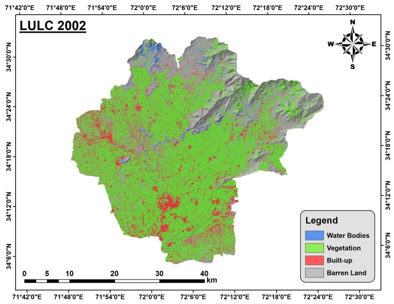
Rapid population growth is a global issue that alters landscapes and affects environmental conditions. This study aims to assess the effects of urbanization on Land Use Land Cover (LULC) changes and their impact on Land Surface Temperature (LST) in District Mardan from 2002 to 2022. By combining remote sensing data on LULC changes with LST measurements, researchers can analyze the relationship between these variables. This analysis sheds light on how LULC changes affect local climate patterns, urban heat island effects, and the overall thermal environment. Data preprocessing was done using ArcGIS 10.8 software. After preprocessing, a supervised classification scheme was applied for 2002 and 2022, using the maximum likelihood algorithm to identify LULC changes. In 2002, the built-up area covered 165.47 km², which increased to 266.70 km² by 2022. Vegetation covers gradually declined over the same period, with a notable shift from vegetation to built-up areas. The study revealed significant changes in District Mardan, including population growth, urban expansion, and infrastructure development. These changes were influenced by various factors, including land cover types. The results of this study can be useful for regional and urban planning, as well as for managing agricultural practices in the future.
References
G. X. Zhao, G. Lin, and T. Warner, “Using Thematic Mapper data for change detection and sustainable use of cultivated land: a case study in the Yellow River delta, China,” Int. J. Remote Sens., vol. 25, no. 13, pp. 2509–2522, Jul. 2004, doi: 10.1080/01431160310001619571.
V. N. Mishra, R. Prasad, P. Kumar, D. K. Gupta, S. Agarwal, and A. Gangwal, “Assessment of Spatio-Temporal Changes in Land Use/Land Cover Over a Decade (2000–2014) Using Earth Observation Datasets: A Case Study of Varanasi District, India,” Iran. J. Sci. Technol. - Trans. Civ. Eng., vol. 43, no. 1, pp. 383–401, Jul. 2019, doi: 10.1007/S40996-018-0172-6/METRICS.
M. M. H. Seyam, M. R. Haque, and M. M. Rahman, “Identifying the land use land cover (LULC) changes using remote sensing and GIS approach: A case study at Bhaluka in Mymensingh, Bangladesh,” Case Stud. Chem. Environ. Eng., vol. 7, p. 100293, Jun. 2023, doi: 10.1016/J.CSCEE.2022.100293.
T. K. Rudel, “Land Use and Land Use Change,” Handbooks Sociol. Soc. Res., pp. 425–438, 2021, doi: 10.1007/978-3-030-77712-8_20.
C. Liping, S. Yujun, and S. Saeed, “Monitoring and predicting land use and land cover changes using remote sensing and GIS techniques—A case study of a hilly area, Jiangle, China,” PLoS One, vol. 13, no. 7, p. e0200493, Jul. 2018, doi: 10.1371/JOURNAL.PONE.0200493.
H. Landsberg, “The Urban Climate, Volume 28 - 1st Edition,” Urban Clim., p. 275, 1981, Accessed: Jul. 18, 2024. [Online]. Available: https://www.elsevier.com/books/the-urban-climate/landsberg/978-0-12-435960-4
B. Ackerman, “Temporal March of the Chicago Heat Island,” J. Appl. Meteorol. Climatol., vol. 24, no. 6, pp. 547–554, Jun. 1985, doi: 10.1175/1520-0450(1985)024.
X. L. Chen, H. M. Zhao, P. X. Li, and Z. Y. Yin, “Remote sensing image-based analysis of the relationship between urban heat island and land use/cover changes,” Remote Sens. Environ., vol. 104, no. 2, pp. 133–146, Sep. 2006, doi: 10.1016/J.RSE.2005.11.016.
P. N. Haindongo, A. M. Kalumba, and I. R. Orimoloye, “Local people’s perceptions about Land Use Cover Change (LULCC) for sustainable human wellbeing in Namibia,” GeoJournal, vol. 87, no. 3, pp. 1727–1741, Jun. 2022, doi: 10.1007/S10708-020-10337-7/METRICS.
T. Bibi, F. Nawaz, A. Abdul Rahman, and A. Latif, “FLOOD HAZARD ASSESSMENT USING PARTICIPATORY APPROACH AND WEIGHTED OVERLAY METHODS,” Int. Arch. Photogramm. Remote Sens. Spat. Inf. Sci., vol. XLII-4-W16, no. 4/W16, pp. 153–160, Oct. 2019, doi: 10.5194/ISPRS-ARCHIVES-XLII-4-W16-153-2019.
D. R. Streutker, “A remote sensing study of the urban heat island of Houston, Texas,” Int. J. Remote Sens., vol. 23, no. 13, pp. 2595–2608, Jul. 2002, doi: 10.1080/01431160110115023.
Z. Hassan et al., “Dynamics of land use and land cover change (LULCC) using geospatial techniques: a case study of Islamabad Pakistan,” Springerplus, vol. 5, no. 1, pp. 1–11, Dec. 2016, doi: 10.1186/S40064-016-2414-Z/FIGURES/6.
C. C. Burt, “The World’s Hottest Recorded Air Temperatures,” Weather. POWER, BEAUTY, Excit., vol. 64, no. 2, pp. 26–33, Jan. 2011, doi: 10.1080/00431672.2011.551594.
E. López, G. Bocco, M. Mendoza, and E. Duhau, “Predicting land-cover and land-use change in the urban fringe: A case in Morelia city, Mexico,” Landsc. Urban Plan., vol. 55, no. 4, pp. 271–285, Aug. 2001, doi: 10.1016/S0169-2046(01)00160-8.
F. Fan, Y. Wang, and Z. Wang, “Temporal and spatial change detecting (1998-2003) and predicting of land use and land cover in Core corridor of Pearl River Delta (China) by using TM and ETM+ images,” Environ. Monit. Assess., vol. 137, no. 1–3, pp. 127–147, Jun. 2008, doi: 10.1007/S10661-007-9734-Y/METRICS.
A. Tariq and H. Shu, “CA-Markov Chain Analysis of Seasonal Land Surface Temperature and Land Use Land Cover Change Using Optical Multi-Temporal Satellite Data of Faisalabad, Pakistan,” Remote Sens. 2020, Vol. 12, Page 3402, vol. 12, no. 20, p. 3402, Oct. 2020, doi: 10.3390/RS12203402.
A. Tariq, J. Yan, and F. Mumtaz, “Land change modeler and CA-Markov chain analysis for land use land cover change using satellite data of Peshawar, Pakistan,” Phys. Chem. Earth, Parts A/B/C, vol. 128, p. 103286, Dec. 2022, doi: 10.1016/J.PCE.2022.103286.
Downloads
Published
How to Cite
Issue
Section
License
Copyright (c) 2024 50SEA

This work is licensed under a Creative Commons Attribution 4.0 International License.


