
Python-Based Land Suitability Analysis for Wheat Cultivation Using MCE and Google Earth Engine in Punjab-Pakistan
Keywords:
Wheat, Land suitability, Google Earth Engine, Sustainable Planning, Remote SensingAbstract
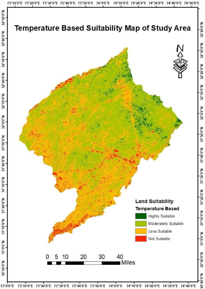
The present study aims to examine the suitability of wheat crops in the four districts of Sheikhupura, Gujranwala, Hafizabad, and Nankana Sahib by conducting a thorough examination of various environmental parameters. The study utilizes the Google Earth Engine and advanced mapping techniques to employ a comprehensive Land Use and Land Cover (LULC) categorization, effectively capturing the prevailing terrain characteristics. The integration of temperature-based and soil-based suitability maps provides a comprehensive understanding of the intricate geographical patterns governing the growth circumstances of wheat. The study highlights a significant finding regarding the identification of very appropriate zones, which encompass around 28% of the total land area (4243 square kilometers) out of complete study site. These zones are particularly noteworthy as they emphasize places that are best for the growing of wheat. Approximately 45% (6819 square kilometers) of the overall land area is classified as moderately suitable, while 15% (2273 square kilometers) of the land area is categorized as less suitable. Furthermore, 16% of the total land area, encompassing 2444 square kilometers, is deemed unsuitable. The rigorous examination of soil parameters, such as pH, drainage, electrical conductivity, and soil type, contributes to a comprehensive comprehension of the soil-related elements that influence the adaptability of wheat crops. The study utilizes a Classification and Regression Tree (CART) methodology to classify crops, resulting in accurate outcomes with a ground truthing accuracy rate of 82%. This study employs a comprehensive approach by integrating temperature and soil-based data to provide a suitability map that enhances the identification of places suitable for wheat growing. Notwithstanding the accuracy of the findings, the research acknowledges certain constraints, including the necessity for heightened farmer consciousness and the incorporation of climate change ramifications. This study offers a comprehensive framework for sustainable agricultural planning, focusing on identifying certain regions that are most suitable for wheat growth. The findings of this research will serve as a valuable resource for guiding future initiatives and decision-making processes related to agricultural development in the studied area.
References
F. Karimi, S. Sultana, A. Shirzadi Babakan, and D. Royall, “Land Suitability Evaluation for Organic Agriculture of Wheat Using GIS and Multicriteria Analysis,” Pap. Appl. Geogr., vol. 4, no. 3, pp. 326–342, Jul. 2018, doi: 10.1080/23754931.2018.1448715.
S. Batool, S. A. Mahmood, and M. Muhammad Ali, “Assessment of land suitability and capability by integrating remote sensing and GIS for agriculture in Potwar region Pakistan,” Int. Arch. Photogramm. Remote Sens. Spat. Inf. Sci., vol. XLVIII-M-1–2023, pp. 409–415, Jun. 2023, doi: 10.5194/ISPRS-ARCHIVES-XLVIII-M-1-2023-409-2023.
R. M. A. Khan, S. A. Mahmood, Y. Miao, and M. Ur Rasheed, “Python Driven Pathways for Wheat Cultivation Incorporating Physico-Climatic Parameters of Growth,” J. Agric. Sci. Technol, vol. 25, no. 4, pp. 893–909, 2023, doi: 10.22034/jast.25.4.9.
M. Dedeoğlu and O. Dengiz, “Generating of land suitability index for wheat with hybrid system approach using AHP and GIS,” Comput. Electron. Agric., vol. 167, p. 105062, Dec. 2019, doi: 10.1016/J.COMPAG.2019.105062.
N. Khubaib et al., “Predicting areas suitable for wheat and maize cultivation under future climate change scenarios in Pakistan,” Clim. Res., vol. 83, pp. 15–25, Feb. 2021, doi: 10.3354/CR01631.
D. B. Debalke, D. A. Mengistu, and T. E. Admas, “Physical land suitability evaluation of rainfed crop production of wheat, barley, and teff in Arsi zone of Ethiopia,” Arab. J. Geosci. 2023 163, vol. 16, no. 3, pp. 1–16, Feb. 2023, doi: 10.1007/S12517-023-11271-X.
“Flash flood susceptibility modeling for drainage basins of Dir Lower Khyber-Pakhtunkhwa: a comparative analysis of morphometric ranking and El-Shamy’s approach.” Accessed: Nov. 23, 2023. [Online]. Available: https://www.spiedigitallibrary.org/conference-proceedings-of-spie/11528/2573062/Flash-flood-susceptibility-modeling-for-drainage-basins-of-Dir-Lower/10.1117/12.2573062.full?SSO=1
A. Karimi, P. Mohammad, A. García-Martínez, D. Moreno-Rangel, D. Gachkar, and S. Gachkar, “New developments and future challenges in reducing and controlling heat island effect in urban areas,” Environ. Dev. Sustain. 2022 2510, vol. 25, no. 10, pp. 10485–10531, Jul. 2022, doi: 10.1007/S10668-022-02530-0.
G. Dadhich, P. R. Patel, and M. H. Kalubarme, “Agriculture land suitability evaluation for wheat cultivation using geomatics for Patan District, India,” Int. J. Agric. Resour. Gov. Ecol., vol. 13, no. 1, pp. 91–108, 2017, doi: 10.1504/IJARGE.2017.084038.
S. S. Hussain and M. Mudasser, “Prospects for wheat production under changing climate in mountain areas of Pakistan – An econometric analysis,” Agric. Syst., vol. 94, no. 2, pp. 494–501, May 2007, doi: 10.1016/J.AGSY.2006.12.001.
“Evaluating Future Climate Projections in Upper Indus Basin through GFDL-ESM2M Model | International Journal of Innovations in Science & Technology.” Accessed: Nov. 23, 2023. [Online]. Available: https://journal.50sea.com/index.php/IJIST/article/view/553/1079
N. Naz and H. Rasheed, “Modeling the Land Suitability using GIS and AHP for Cotton Cultivation in Punjab, Pakistan,” Pakistan J. Sci. Ind. Res. Ser. A Phys. Sci., vol. 59, no. 2, pp. 96–108, Jun. 2016, doi: 10.52763/PJSIR.PHYS.SCI.59.2.2016.96.108.
S. Roholla Mousavi, F. Sarmadian, Z. Alijani, and A. Taati, “Land suitability evaluation for irrigating wheat by Geopedological approach and Geographic Information System: A case study of Qazvin plain, Iran,” Eurasian J. Soil Sci., vol. 6, no. 3, pp. 275–284, Jul. 2017, doi: 10.18393/EJSS.297251.
M. Waleed, M. Sajjad, M. S. Shazil, M. Tariq, and M. T. Alam, “Machine learning-based spatial-temporal assessment and change transition analysis of wetlands: An application of Google Earth Engine in Sylhet, Bangladesh (1985–2022),” Ecol. Inform., vol. 75, p. 102075, Jul. 2023, doi: 10.1016/J.ECOINF.2023.102075.
R. E. Kennedy et al., “Implementation of the LandTrendr Algorithm on Google Earth Engine,” Remote Sens. 2018, Vol. 10, Page 691, vol. 10, no. 5, p. 691, May 2018, doi: 10.3390/RS10050691.
M. Imran, K. Sumra, N. Abbas, and I. Majeed, “Spatial distribution and opportunity mapping: Applicability of evidence-based policy implications in Punjab using remote sensing and global products,” Sustain. Cities Soc., vol. 50, p. 101652, Oct. 2019, doi: 10.1016/J.SCS.2019.101652.
I. Mazhar, A. Hamid, and S. Afzal, “Groundwater quality assessment and human health risks in Gujranwala District, Pakistan,” Environ. Earth Sci., vol. 78, no. 22, pp. 1–12, Nov. 2019, doi: 10.1007/S12665-019-8644-Y/METRICS.
A. Tariq, S. Siddiqui, A. Sharifi, and S. H. I. A. Shah, “Impact of spatio-temporal land surface temperature on cropping pattern and land use and land cover changes using satellite imagery, Hafizabad District, Punjab, Province of Pakistan,” Arab. J. Geosci. 2022 1511, vol. 15, no. 11, pp. 1–16, May 2022, doi: 10.1007/S12517-022-10238-8.
D. Bhatt, S. Maskey, M. S. Babel, S. Uhlenbrook, and K. C. Prasad, “Climate trends and impacts on crop production in the Koshi River basin of Nepal,” Reg. Environ. Chang., vol. 14, no. 4, pp. 1291–1301, Dec. 2014, doi: 10.1007/S10113-013-0576-6/FIGURES/5.
S. Ara, M. A. U. J. Alif, and K. M. A. Islam, “Impact of Tourism on LULC and LST in a Coastal Island of Bangladesh: A Geospatial Approach on St. Martin’s Island of Bay of Bengal,” J. Indian Soc. Remote Sens., vol. 49, no. 10, pp. 2329–2345, Oct. 2021, doi: 10.1007/S12524-021-01389-4/METRICS.
W. Zhao and S. B. Duan, “Reconstruction of daytime land surface temperatures under cloud-covered conditions using integrated MODIS/Terra land products and MSG geostationary satellite data,” Remote Sens. Environ., vol. 247, p. 111931, Sep. 2020, doi: 10.1016/J.RSE.2020.111931.
J. Więckowski and W. Sałabun, “Sensitivity analysis approaches in multi-criteria decision analysis: A systematic review,” Appl. Soft Comput., vol. 148, p. 110915, Nov. 2023, doi: 10.1016/J.ASOC.2023.110915.
D. Yadav, H. Dem, J. Paulo Costa, S. A. Gallo, and J. Maheut, “Multi-Criteria Analysis for the Evaluation of Urban Freight Logistics Solutions: A Systematic Literature Review,” Math. 2023, Vol. 11, Page 4089, vol. 11, no. 19, p. 4089, Sep. 2023, doi: 10.3390/MATH11194089.
E. A. Njoku, P. E. Akpan, A. E. Effiong, and I. O. Babatunde, “The effects of station density in geostatistical prediction of air temperatures in Sweden: A comparison of two interpolation techniques,” Resour. Environ. Sustain., vol. 11, p. 100092, Mar. 2023, doi: 10.1016/J.RESENV.2022.100092.
Z. Ijaz, C. Zhao, N. Ijaz, Z. ur Rehman, and A. Ijaz, “Development and optimization of geotechnical soil maps using various geostatistical and spatial interpolation techniques: a comprehensive study,” Bull. Eng. Geol. Environ., vol. 82, no. 6, pp. 1–21, Jun. 2023, doi: 10.1007/S10064-023-03244-X/METRICS.
Published
How to Cite
Issue
Section
License
Copyright (c) 2024 50SEA

This work is licensed under a Creative Commons Attribution 4.0 International License.


