
Flood Inundation Mapping Using Multi-Temporal Datasets
DOI:
https://doi.org/10.33411/IJIST/2020020301Keywords:
Natural Disasters, Pre and Post Flood , Land use, Land coverAbstract
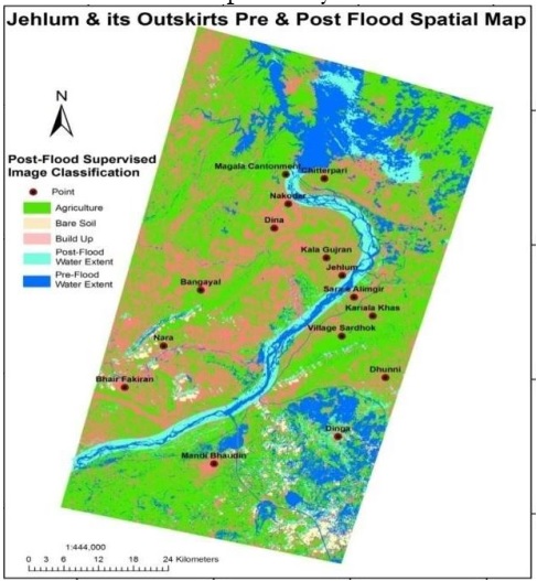
Floods are considered the most frequent natural catastrophic events, which effect the human lives and infrastructure. Flooding causes tremendous loss of life and property every year. We used satellite imagery to map flood inundation in Jehlum river for the both pre and post flood scenarios and classified it into major landuse including vegetation, water body, buildup land and the bare soil. The results show that about 40% area was agricultural land, 29% was bare soil, 16% was build up land and 12% area was noted as water body.The categorization of the post flood areas, showed that flood has destroyed the buildup and agriculture lands.The superimposition proposed that agricultural land was 43% before the flood which reduced up to 31%,the normal flow of water was 12% before flood which was increased up to 33%, build up area and bare soil was also decreased up to 10% and 25% respectively. Remote sensing and GIS proved efficient in convergence of optimistic results.
References
Ahmed, M.S., Eldin, E., AbdElkawy, F., Tarek, M.A., Speckle noise reduction in SAR images using adaptive morphological filter. 2010 10th International Conference on Intelligent Systems Design and Applications. Pp: 260-265, 2011.
Cutter SL, Barnes L, Berry M, Burton C, Evans E, Tate E, Webb J. A place-based model for understanding community resilience to natural disasters. Global environmental change. VOL 18, issue 4, pp :598-606, 2008.
C. M. Bhatt*, G. Srinivasa Rao, Asiya Begum, P. Manjusree, S. V. S. P. Sharma, L. Prasanna and V. Bhanumurthurthy “Satellite images for extraction of flood disaster footprints and assessing the disaster impact: Brahmaputra floods of June–July 2012, Assam India”, Vol 104, issue 12, pp: 1692 – 1700, 2013.
Huang et.al.Geomatics Natural Hazards Risk, GEOMAT NAT HAZ RISK, Vol
, issue 2, pp. 747-763, 2016,
Huang et.al.Geomatics Natural Hazards Risk, GEOMAT NAT HAZ RISK, Vol 12 , issue 1, pp. 384-401, 2021.
Bhatt, C. M., Rao, G. S., Farooq, M., Manjusree, P., Shukla, A., Sharma, S. V. S. P., Kulkarni, S. S., Begum, A., Bhanumurthy, V., Diwakar, P. G., Dadhwal, V.K. Satellite based assessment of the catastrophic Jhelum floods of September 2014, Jammu & Kashmir, India. Vol 8, Pp: 309- 327, 2017.
O’Keefe, P.; Westgate, K.; Wisner, B. Taking the naturalness out of natural disasters. Nature , Vol 260, pp: 566–567, 1976.
Sanyal, J.; Lu, X.X. Application of remote sensing in flood management with special reference to monsoon Asia: A review. Nat. Hazards ,Vol 33, pp: 283–301, 2004.
Berz, G.; Kron, W.; Loster, T.; Rauch, E.; Schimetschek, J.; Schmieder, J.; Siebert, A.; Smolka, A.; Wirtz, A. World map of natural hazards—A global view of the distribution and intensity of significant exposures. Nat. Hazards Vol 23, pp: 443–465, 2001.
Akıncı, H.; Erdoğan, S. Designing a flood forecasting and inundation-mapping system integrated with spatial data infrastructures for Turkey. Nat. Hazards , Vol 71, pp: 895– 911, 2014.
Smith, L.C. Satellite remote sensing of river inundation area, stage, and discharge: A review. Hydrol. Process. Vol 11, pp: 1427–1439, 1997.
Brivio, P.A.; Colombo, R.; Maggi, M.; Tomasoni, R. Integration of remote sensing data and GIS for accurate mapping of flooded areas. Int. J. Remote Sens. Vol 23, pp: 429– 441, 2002.
Wang, Y.; Colby, J.D.; Mulcahy, K.A. An efficient method for mapping flood extent in a coastal floodplain using Landsat TM and DEM data. Int. J. Remote Sens. Vol 23, pp: 3681–3696, 2002.
Rahman, M.S.; Di, L. The state of the art of spaceborne remote sensing in flood management. Nat. Hazards Vol85, pp: 1223–1248, 2017.
Li, L.; Chen, Y.; Yu, X.; Liu, R.; Huang, C. Sub-pixel flood inundation mapping from multispectral remotely sensed images based on discrete particle swarm optimization. ISPRS J. Photogramm. Remote Sens. Vol 101, pp: 10–21, 2015.
Asgary, A., Anjum, M. I., &Azimi, N. Disaster recovery and business continuity after the 2010 flood in Pakistan: Case of small businesses. International journal of disaster risk reduction, Vol 2, pp: 46-56, 2012.
Aparna, N., Ramani, A. V., &Nagaraja, R. Risk management support through India Remote Sensing Satellites. The International Archives of Photogrammetry, Remote Sensing and Spatial Information Sciences, Vol 40, issue 8,pp: 1, 2014.
Published
How to Cite
Issue
Section
License
Copyright (c) 2020 50Sea

This work is licensed under a Creative Commons Attribution 4.0 International License.


