
Python Based Modelling of Flood Damage Assessment Using High-Resolution Aerial Imagery
Abstract
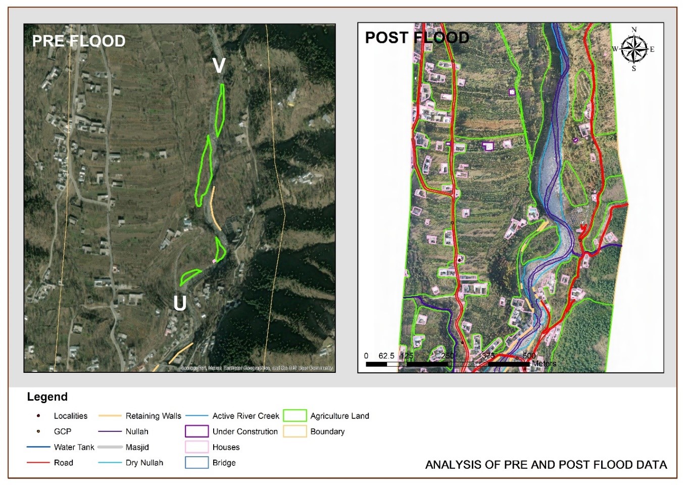
Flood is a natural disaster that can cause devastating impacts on the community, infrastructure, and the environment. UAVs enable to compute the extent of the flood and to identify the vulnerable areas prone to future flooding, assisting in the formulation of effective mitigation strategies. This study presents a case study of Barwai Khwar, Swat, Khyber Pakhtunkhwa (KPK), pre-flood image attained from Google Earth Pro and the post-flood aerial imagery was collected by using unmanned aerial vehicles (UAVs). To capture the detailed visual information of the flood-affected region and to assess the extent of the flood damage the acquired imagery was then processed by using advanced image processing algorithms to extract essential information, such as inundation extent, floodwater depth, and changes in land cover. This procedure assists in evaluating the precise damage assessment and development of effective recovery and mitigation strategies. Results revealed that the 2022 flood in Barwai Khowar's large agricultural land was submerged (14758.9 perimeters), leading to a significant loss in crop yield and potential long-term impacts on food security. Additionally, critical infrastructure, including roads, bridges, and buildings suffered substantial damage. The destructed area of the retaining wall is 2184m (2km), housing damage is 1074.9m and 82.6 m of Nullah was calculated in this region. Moreover, the application of such technologies can facilitate more informed and timely responses to natural disasters, enhancing the overall resilience of communities and ecosystems.
References
U. Iqbal, M. Z. Bin Riaz, J. Zhao, J. Barthelemy, and P. Perez, “Drones for Flood Monitoring, Mapping and Detection: A Bibliometric Review,” Drones, vol. 7, no. 1, pp. 1–29, 2023, doi: 10.3390/drones7010032.
M. N. Abdel-Mooty, W. El-Dakhakhni, and P. Coulibaly, “Data-Driven Community Flood Resilience Prediction,” Water (Switzerland), vol. 14, no. 13, 2022, doi: 10.3390/w14132120.
A. R. M. Amen et al., “Mapping of Flood-Prone Areas Utilizing GIS Techniques and Remote Sensing : A Case Study of Duhok , Kurdistan Region of Iraq,” 2023.
S. Mahmood, A. Rahman, and R. Shaw, “Spatial appraisal of flood risk assessment and evaluation using integrated hydro-probabilistic approach in Panjkora River Basin , Pakistan,” 2019.
M. Dilley, “Natural Disaster Hotspots: A Global Risk Analysis - Maxx Dilley - Google Books.” 2005.
N. M. Dang, M. S. Babel, and H. T. Luong, “Evaluation of food risk parameters in the Day River Flood Diversion Area, Red River Delta, Vietnam,” Nat. Hazards, vol. 56, no. 1, pp. 169–194, 2011, doi: 10.1007/s11069-010-9558-x.
T. Bibi, F. Nawaz, A. Rahman, K. Razak, and A. Latif, “FLOOD RISK ASSESSMENT OF RIVER KABUL AND SWAT CATCHMENT AREA: DISTRICT CHARSADDA, PAKISTAN,” ISPRS - Int. Arch. Photogramm. Remote Sens. Spat. Inf. Sci., vol. XLII-4/W9, pp. 105–113, Oct. 2018, doi: 10.5194/isprs-archives-XLII-4-W9-105-2018.
T. F. Stocker, S. K. Allen, V. Bex, and P. M. Midgley, “Climate Change 2013 The Physical Science Basis Working Group I Contribution to the Fifth Assessment Report of the Intergovernmental Panel on Climate Change Edited by,” 2013.
M.-S. Aribisala, O.D.; Yum, S.-G.; Adhikari, M.D.; Song, “Sustainability _ Free Full-Text _ Flood Damage Assessment_ A Review of Microscale Methodologies for Residential Buildings.”
C. X. Ashfaq Ahmad Shah, Ayat Ullah, Nasir Abbas Khan, Muhammad Haroon Shah, Rasheed Ahmed, Syed Tauseef Hassan, Muhammad Atiq Ur Rehman Tariq, “Frontiers _ GIS-based flood susceptibility mapping using bivariate statistical model in Swat River Basin, Eastern Hindukush region, Pakistan.” Interdisciplinary Climate Studies, 2023. doi: https://doi.org/10.3389/fenvs.2023.1088126.
A. A. Memon, S. Muhammad, S. Rahman, and M. Haq, “Flood monitoring and damage assessment using water indices: A case study of Pakistan flood-2012,” Egypt. J. Remote Sens. Sp. Sci., vol. 18, no. 1, pp. 99–106, Jun. 2015, doi: 10.1016/J.EJRS.2015.03.003.
Govt Pakistan, “Pakistan Floods 2022_ Post-Disaster Needs Assessment - Pakistan _ ReliefWeb.” 2022.
UNDP, “Pakistan floods 2022,” 2022.
Z. U. Rahman et al., “GIS-based flood susceptibility mapping using bivariate statistical model in Swat River Basin, Eastern Hindukush region, Pakistan,” Front. Environ. Sci., vol. 11, 2023, doi: 10.3389/fenvs.2023.1178540.
S. Guan, C. Tao, and S. Liu, “Proceedings of spie,” no. April, 2023, doi: 10.1117/12.2658632.
K. J. Daniel Whitehurst and K. K. and J. Weeks, “Post-Flood Analysis for Damage and Restoration Assessment Using Drone Imagery,” pp. 1–17, 2022.
FAO, “Food and Agriculture Organization of the United State,” 2016.
H. Mcgrath and P. N. Gohl, “Accessing the Impact of Meteorological Variables on Machine Learning Flood Susceptibility Mapping,” 2022.
T. D. E. M. Worlddem, “Flood hazard assessment and mapping of River Swat using HEC-RAS 2D Flood hazard assessment and mapping of River Swat using HEC ‑ RAS 2D model and high ‑ resolution 12 ‑ m TanDEM ‑ X DEM,” Nat. Hazards, no. June 2020, 2019, doi: 10.1007/s11069-019-03638-9.
O. S. Yilmaz, “Flood hazard susceptibility areas mapping using Analytical Hierarchical Process (AHP), Frequency Ratio (FR) and AHP-FR ensemble based on Geographic Information Systems (GIS): a case study for Kastamonu, Türkiye,” Acta Geophys., vol. 70, no. 6, pp. 2747–2769, 2022, doi: 10.1007/s11600-022-00882-9.
Anne Crosby, “How are drones used in flooding management_.” 2022.
A. Ntal, “Flood forecasting _ Aerial drones to predict and assess flood damage.” Twinn, 2015.
S. Mastura et al., “Science & Justice Applications of drone in disaster management : A scoping review,” Sci. Justice, vol. 62, no. 1, pp. 30–42, 2022, doi: 10.1016/j.scijus.2021.11.002.
eunghee P. Park, Dai Quoc, Tran Minsoo Daekyo JungS, “Remote Sensing Damage-Map Estimation Using UAV Images and Deep Learning Algorithms for Disaster Management System.” Remote Sensing 12(24), 4169, 2020. doi: https://doi.org/10.3390/rs12244169.
H. Rizk, Y. Nishimur, H. Yamaguchi, and T. Higashino, “Drone-based water level detection in flood disasters,” International Journal of Environmental Research and Public Health, vol. 19, no. 1. 2022. doi: 10.3390/ijerph19010237.
H. Events, S. Adams, C. Friedland, and M. Levitan, “Unmanned Aerial Vehicle Data Acquisition for Damage Assessment in Hurricane Events,” 2010.
Published
How to Cite
Issue
Section
License
Copyright (c) 2023 50SEA

This work is licensed under a Creative Commons Attribution 4.0 International License.


