
A Study of Active Chaman Fault System (CFS) Using SRTM DEM
DOI:
https://doi.org/10.33411/ijist/2021030103Keywords:
Chaman fault, LISA, DEM, Strike slip, Hypsometric integral, Neo tectonics , PakistanAbstract
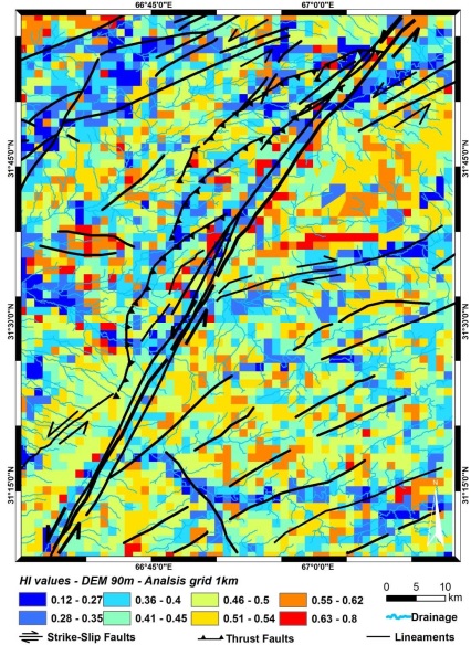
Chaman fault is a seismically active fault running over 850km in western region of Pakistan and Afghanistan. It is a major geological structure between Indian and Eurasian plates. Chaman fault is a strike slip fault which is slipping nearly at the rate of 10mm per year. This research includes the evaluation of lithological processes and neotectonics activity using Hypsometric Integral (HI). We calculated values of hypsometric integral using SRTM DEM with 90m spatial resolution in active region of Chaman Fault (CF) and in its locality. We analyzed different mean, minimum and maximum elevations using regular square grids and measured the degree of spatial distribution of HI using Local Indices (LI) of Spatial Autocorrelation (LISA). LISA provides auto correlation for the cluster analysis of hotspots and cold spots of HI values to discriminate uplifted and eroded regions.
References
Apel, E.R., Burgmann, P., Bannerjee, and B. Nagarajan, 2006, “Geodetically constrained Indian plate motion and implications for plate boundary deformation”, in American Geophysical Union, Fall Meeting 2006.
Abdullah, S., and V.M. Chmyrio , Map of mineral resources of Afghanistan: Ministry of Mines and Industries of the Democratic Republic of Afghanistan, Department of Geological and Mineral Survey, 1977.
Amrhein, C., and H. Reynolds, “Using the Getis statistic to explore method aggregation effects in metropolitan Toronto census data”, Canadian Geographer, Vol 41, issue 2, pp : 137-149, 1997.
Andermann, C., and R. Gloaguen, “Estimation of erosion in tectonically active orogenies.Example from the Bhotekoshi catchment, Himalaya (Nepal)”, International Journal of Remote Sensing, Vol 30, issue 12, pp; 3075-3096, 2009.
Anselin, L., “Local indicators of spatial association-LISA”, Geographical Analysis, Vol 27, issue 2, pp: 93-115, 1995.
Bannert, D., Cheema, A, and A. Ahmad, “The geology of the Western Fold Felt: Structural interpretation of the Landsat-M SS Satellite Imagery”. Hannover: Federal Institute of Geosciences and Natural Resources, 1992.
Blanchard, S.D., Rogan, J., and D.W. Woodcock, “Geomorphic Change Analy sis Using ASTER and SRTM Digital Elevation Models in Central Massachusetts, USA”, GIScience and Remote Sensing, Vol 47, issue 1, pp: 1-24, 2010.
Burtman, V., and P. Molnar, Geological and geophysical evidence for deep subduction of continental crust beneath the Pamir, Special Paper Geological Society of America, Vol 281, pp: 82, 1993.
Calkins, J., Jamiluudin, S., Bhuyan, K., and A.Hussain, “Geology and mineral resources of the chitralpartsan area, hindukush range, northern Pakistan”, United States Geological Survey Paper, Vol 33, pp: 716, 1981.
Chen, Y.C., Sung, Q. and K.Y. Cheng, “Along-strike variations of morphotectonic s features in the Western Foothills of Taiwan: Tectonic implications based on stream-gradient and hypsometric analysis”, Geomorphology, Vol 56, issue 1-2, pp: 109-137, 2003.
Chou, Y., Exploring Spatial Anaylsis in Geographic information systems. Santa Fe: Onward Press, pp: 474, 1997.
Cliff, A. and J.K. Ord, Spatial processes, models and applications. London: Pion Ltd., pp: 260, 1981.
Doebrich, J.L., and R.R.Wahl, Geological and mineral resources map of Afghanistan, version 1, compiled by USGS, 2006.
Dewey, J., “The tectonic evolution of the india-eurasia collision zone”, Eclogae Geologicae Helveticae, Vol 82, issue 3, pp: 717-734, 1989.
Diniz-Filho, J. A. F., Bini, L. M . and Hawkins, B. A., “Spatial autocorrelatio and red herrings in geographical ecology ” , Global Ecology and Biogeography, Vol 12, issue 1, pp: 53-64, 2003.
Gansser, A., Geology of the Himalayas, New York: Interscience, 1964.
Getis, A., and K. Ord, “Local spatial statistics: An overview”, in Spatial Analysis: Modelling in a GIS Environment, Cambridge: GeoInf. Int., pp: 261-277, 1996.
Gloaguen, R., Marpu, P. R., and I. Niemeyer, “Automatic extraction of faults and fractal analysis from remote sensing data”, Nonlinear Processes in Geophysics, Vol 14 pp: 131-138, 2007.
Haining, R., Spatial data analysis in the social and environmental sciences.Cambridge: Cambridge university press., pp: 410, 1990.
Hildebrand, P.R., Searle, M.P., Shakirullah, Z. A. K., and H.J. van Heijst, “Geological evolution of the Hindu Kush, NW Pakistan: Active margin to continent-continent collision zone”, in Tectonics of the Nanga Parbat syntaxis and the western Himalaya, Geological Society, London, Special Publications Vol 170, pp: 277–293, 2000.
Humayon, M., Lillie, R.J. and Lawrence, R.D., “Structural interpretation of eastern Sulaimanfoldbelt and foredeep, Pakistan”, Tectonics, Vol 10, issue 2, pp: 299-324, 1991.
Hildebrand, P.R., Noble, S.R., Searle, M.P., Waters, D. J., and R.R. Parrish, “Old origin for an active mountain range: Geology and geochronology of the eastern Hindu Kush, Pakistan”, Geological Society America Bulletin, Vol 113, issue 5, pp: 625-639, 2001
Published
How to Cite
Issue
Section
License
Copyright (c) 2021 50sea

This work is licensed under a Creative Commons Attribution 4.0 International License.


