
River Profile Modeling Through Surface Deformation Using RS/GIS, A Case Study Swat River
DOI:
https://doi.org/10.33411/ijist/2020020303Keywords:
Natural Disasters, Pre and Post Flood, Land use, Land coverAbstract
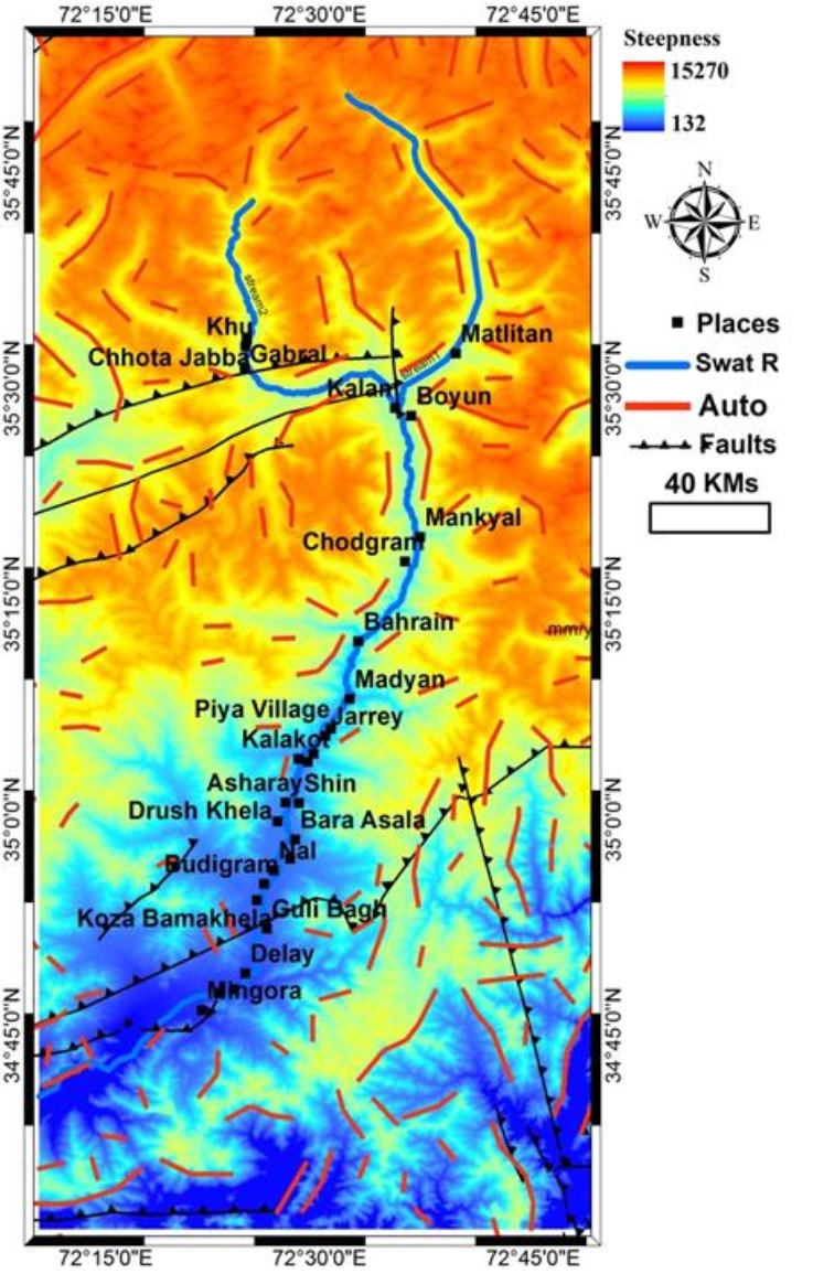
The objective of this appraisal is to determine the feasibility of dam sites in Swat Valley and its peripheries (Northern Pakistan). We exploited SRTM DEM with a spatial resolution of 90m to extract various geomorphic indexes for the dam site feasibility. This research aims at pinpointing areas which can be opted for small dam constructions to overcome the electricity crisis in Pakistan to some extent to meet the national electricity needs. We exercised River profile analysis (RPA), D8 flow popular algorithm, Concavity, Steepness, and Hack-gradient methods to prepare interpolated maps for the Steepness index, Concavity index, Relative uplift rates, and other parameters like value zoom, vector zoom, surface zoom, density zoom, relief zoom and contour map. The drainage pattern of this area indicates that there are high relative uplift rates, erosion, steepness and concavity in NE, NW and SW. The DEM based RPA develops as much easier and faster approach to demarcate sites influenced by neotectonics.
References
Arnold, J.G., Srinisvan, R., Muttiah, R.S., Williams, J.R., Large area hydrologic modeling and assessment. Part I: model development. J. Am. Water Resour. Assoc. Vol 34, issue 1, pp:73–89, 1998.
Arnold, J.G., Muttiah, R.S., Srinivasan, R., Allen, P.M., Regional estimation base flow and groundwater recharge in the upper Mississippi River basin. Vol 227, issue 1, pp: 21–40, 2000.
Beasley, D.B., Huggins, L.F., Monke, E.J., ANSWERS: a model for watershed planning. Trans. ASAE , Vol 23, issue 4, pp: 938–944, 1980.
Chen, J.Y., Adams, B.J., Integration of artificial neural networks with conceptual models in rainfall-runoff modeling. J. Hydrol. Vol 318, pp: 232–249, 2006.
Dawson, C.W., Wilby, R.L., Hydrological modelling using artificial neural networks. Prog. Phys. Geog. Vol 25, pp: 80–108, 2001.
De Roo, A.P.J., Wesseling, C.G., Ritsema, C.J., LISEM: a single event physically based hydrological and soil erosion model for drainage basins: I. Theory, input and output. Hydrol. Vol 10, pp: 1107–1117, 1996.
Bell, T. H. Statistical features of sea-floor topography. Deep Sea Research, Vol 22, pp; 883–892, 1975.
Birnir, B., Smith, T. R., & Merchant, G. E. The scaling of fluvial landscapes. Computers & Geosciences, Vol 27, pp: 1189–1216, 2001.
Memoir - Geological Society of America, 201, 66. Chase, C. G. Fluvial land sculpting and the fractal dimension of topography. Geomorphology, Vol 5, pp: 39–57, 1992.
In P. R. Wilcock & R. M. Iverson (Eds.), Prediction in Geomorphology, Geophys. Mono, Vol. 135, pp. 103–132, 2013.
Durand, M., Gleason, C. J., Garambois, P. A., Bjerklie, D., Smith, L. C., Roux, H., et al. An intercomparison of remote sensing river discharge estimation algorithms from measurements of river height, width, and slope. Water Resources Research, Vol 52, pp: 4527–4549, 2016.
Fishwick, S. Surface wave tomography: Imaging of the lithosphere-asthenosphere boundary beneath central and southern Africa?, Vol 120, pp: 63–73, 2010.
Gallant, J. C., Moore, I. A., Hutchinson, M. F., & Gessler, P. Estimating fractal dimension of profiles: A comparison of methods. Mathematical Geology, Vol 26, issue 4, pp: 455–481, 1994.
Giresse, P., Hoang, C.-T., & Kouyoumontzakis, G. Analysis of vertical movements deduced from a geochronological study of marine Pleistocene deposits, southern coast of Angola. Journal of African Earth Sciences, Vol 2, issue 2, pp: 177–187, 1984.
Goren, L., Fox, M., & Willett, S. D. Tectonics from fluvial topography using formal linear inversion: Theory and applications to the Inyo Mountains, California. Journal of Geophysical Research: Earth Surface, Vol 119, pp: 1651–1681, 2014.
Guiraud, M., Buta-Neto, A., & Quesne, D. Segmentation and differential post-rift uplift at the Angola margin as recorded by the transform-rifted Benguela and oblique-to- orthogonal-rifted Kwanza basins. Marine and Petroleum Geology, Vol 27, pp: 1040– 1068, 2010.
Gurnis, M., Mitrovica, J. X., Ritsema, J., & van Heijst, H.-J. Constraining mantle density structure using geological evidence of surface uplift rates: The case of the African superplume. Geochemistry, Geophysics, Geosystems, Vol 1, pp: 1020, 2000.
Hager, B. H., & Richards, M. A. Long-wavelength variations in Earth's geoid: physical models and dynamic implications. Philosophical Transactions of the Royal Society London A, Vol 328, pp: 309–327, 1989.
Hancock, G. R., Martinez, C., Evans, K. G., & Moliere, D. R. A comparison SRTM and high-resolution digital elevation models and their use in catchment geomorphology and hydrology: Australian examples, Earth Surf. Processes Landforms, Vol 31, pp; 1394–1412, 2006.
Published
How to Cite
Issue
Section
License
Copyright (c) 2020 50Sea

This work is licensed under a Creative Commons Attribution 4.0 International License.


