
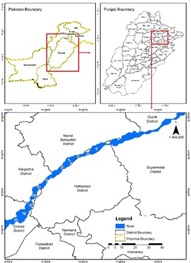
Riverbank Erosion & Consequent Land Settlement Issues: A Case of River Chenab, District Hafizabad
DOI:
https://doi.org/10.33411/ijist/2021030402Keywords:
Riverbank Erosion, Geographical Information System (GIS), Remote Sensing (RS), Massavi map, Disaster Risk Reduction (DRR), Revenue Land RecordAbstract
When calamity strikes, it causes damage but it also provides opportunities for newer learnings opportunities and better preparedness to combat menace. Pakistan is agrarian economy and comprises fertile plains. According to Pakistan Bureau of Statistics, agriculture contributes to 24 percent of national Gross Domestic Product. Agriculture is dependent on water needs, met through water channels fed by rivers originating mostly from glacial sources existing in northern part of the country. The country hosts five major rivers, namely Indus Jhelum, Chenab, Ravi, and Sutlej. The dendritic river patterns follow gravity flow causing frequent morphological changes and riverbank erosion is the most significant phenomenon which acts as hazard for farming communities in terms of loss of shelter, livelihood, and landholdings. An in-time identification of the issue is the real concern nowadays. Presently, different tools are available for instant interpretation of riverbank erosion like Remote Sensing (RS) and Geographical Information System (GIS), which are not only good for instant identification but also helpful for precise estimation of historical losses. Landsat images for years 2009, 2013, and 2017 have used to make an initial assessment of erosion hotspots. High-resolution satellite imagery from Google Earth is also used for meticulous analysis. The analysis shows that beyond other factors, average riverbank displacement rate due to erosion directly depends on rise in water levels. The study provides systematic bases to estimate the losses precisely. The study is useful for damages assessment of land and livelihood to device relief packages for the affected communities. The study also builds the capacity in resolving land settlement issues consequent to the riverbank erosion phenomenon.
References
. Ahmed, A. A. and A. Fawzi, "Meandering and Bank Erosion of the River Nile and Its Environmental Impact on the Area Between Sohag and El-Minia, Egypt." Arabian Journal of Geosciences, (2011) 04: 01-11.
. Raza, M. T., Chenab Erosion Eats Away 200 Houses, (2015), https://www.dawn.com/news/1170268, LastAccessDate: April 15, 2020
. Chaudhry, F., Erosion Makes People Homeless, (2016) https://www.dawn.com/news/1285296, LastAccessDate: April 15, 2020
. Dabojani, D., et al. (2014). River Change Detection and Bankline Erosion Recognition using Remote Sensing and GIS. Forum Geografic.
. Nath, B., et al., "Trends Analysis of River Bank Erosion at Chandpur, Bangladesh: A Remote Sensing and GIS Approach." International Journal of Geomatics and Geosciences (2013), 3(3): 454-463.
. Aher, S. P., et al., "River Change Detection and Bank Erosion Identification Using Topographical and Remote Sensing Data." International Journal of Applied Information Systems (2012), 02(03): 01-07.
. Lam-Dao, N., et al., "Change Detection of Land Use and Riverbank in Mekong Delta, Vietnam Using Time Series Remotely Sensed Data." Journal of Resources and Ecology (2011) 2(4): 370-375.
. Sarkar, A., et al., "RS-GIS Based Assessment of River Dynamics of Brahmaputra River in India. " Journal of Water Resource and Protection (2012), 4(02): 63.
. Casana, J., "Satellite Imagery-Based Analysis of Archaeological Looting in Syria." Near Eastern Archaeology (2015), 78(03): 142-1
. Miller, H. M., et al., Users, Uses, and Value of Landsat Satellite Imagery-Results from the 2012 Survey of Users: 01-51 (2013)
. Uddin, K., et al., "Assessment of morphological changes and vulnerability of river bank erosion alongside the river Jamuna using remote sensing." Journal of Earth Science and Engineering (2011) 1(1): 29-34.
. Dhara, S. and B. K. Mondal, "River Bank Erosion and Changing Course of River Saptamukhi and Muriganga of Namkhana Island." West Bengal: Geoinformatics for Sustainable Environment Management (2019) II: 161-170.
. Kamal, M. and M. J. Abedin, "Riverbank Erosion and Migration: A Study on Displaced People from Governance and Cultural Perspective." Society & Change (2019) XIII(04): 23-34.
. Rafatullah, N. I. and K. Hossain, "Socio-Economic Vulnerability of Riverbank Erosion of Displacees: Case Study of Coastal Villages in Bangladesh." Indian Journal of Ecology (2019), 46(1): 34-38.
. Aslam, R. M. S., et al., "Baseline Data Preparation of Revenue Land Record." International Journal of Scientific and Engineering Research (2015), 06(08): 1792-1799.
. Masood, A., et al., Precise Extraction of Village Boundary from Revenue Massavi Maps Using GIS/RS Techniques. (2019) 2nd International Congress on Earth Sciences, Nusa Dua Bali, Indonesia.
. Ellis, E. C. and N. Ramankutty, "Putting People in the Map: Anthropogenic Biomes of the World." Frontiers in Ecology and the Environment (2008), 6(8): 439-447.
. Tripathy, B. and T. Mondal, "Impact of Riverbank erosion on Human life." Thematics Journal of Geography (2019), 8(9): 53-56.
. Duong Thi, T. and D. Do Minh, "Riverbank Stability Assessment under River Water Level Changes and Hydraulic Erosion." (2019) Water 11(12): 2598.
. Das, T. K., et al., "River Bank Erosion Induced Human Displacement and Its Consequences." Living Review of Landscape Research (2014) 8(3): 01-35.
. Durlević, U, et al., "Multihazard susceptibility assessment: A case study – Municipality of Štrpce (Southern Serbia)" (2021) Open Geosciences, vol. 13, no. 1, 2021, pp. 1414-1431.
. Kundu, R. R., et al., Resilience of Riverine Households towards Dynamic Vulnerability. International Conference on Agriculture and Allied Sciences: The Productivity, Food Security and Ecology New Delhi, India. (2018) 15: 27-31.
. Munna, G. M., et al., "Assessment of Socio-Economic Impacts of Surma River Bank Erosion by Using GIS & Statistical Study." International Journal of Science and Engineering Invention (2020) 6(01): 01-04.
. Lovric, N. and R. Tosic, "Assessment of Bank Erosion, Accretion and Channel Shifting Using Remote Sensing and GIS: Case Study–Lower Course of the Bosna River." Quaestiones Geographicae (2016) 35(1): 81-92.
. Chatterjee, S. and B. Mistri, "Impact of River Bank Erosion on Human Life: A Case Study in Shantipur Block, Nadia District, West Bengal." International Journal of Humanities and Social Science Invention (2013), 02(08): 108-111.
. Belo, D. X. A., et al., "Analysis of Land Erosion Due to Mining of Clay Material in Sidorejo Village, Sleman District, Yogyakarta." Geographia Technica (2020) 15(Special): 33-41.
Published
How to Cite
Issue
Section
License
Copyright (c) 2021 50Sea

This work is licensed under a Creative Commons Attribution 4.0 International License.


