
Assessment and Monitoring of VIIRS-DNB and SQML-L light Pollution in Lahore-Pakistan
DOI:
https://doi.org/10.33411/ijist/2022040107Keywords:
Light Pollution, Sky Glow, VIIRS, SQML, Sum of lights, Mean Night-time Light, Standard deviation Night-time Light, Remote SensingAbstract
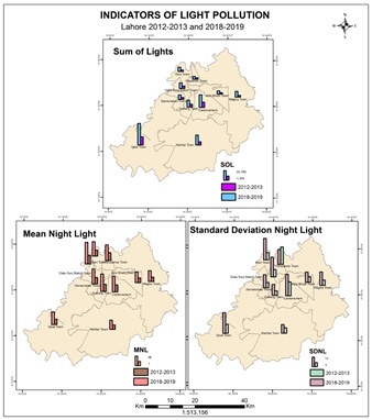
The usage of artificial light is excessive and improper. Earth's night picture has changed significantly from space and studies have shown that over-exposure to artificial light in the night can influence animals, the environment and human beings. The purpose of this study was to monitor and measure skylights of Lahore City and temporary light pollution from 2012-2019. The Suite-Day/Night band of the Visible Image Radiometer was used for time changes analysis with GIS and Remote Sensing tools. Indicators were established as a table tool through zonal statistics, and a field survey was also undertaken to measure the Sky-Glow of Lahore with Sky Quality Meter-L. The results suggest that from 2012 to 2019, light pollution rose by 23.43 percent. Results suggest that around 53.99% of Lahore suffered from light pollution. The number of lights in Lahore has increased by 161.82 percent between 2012 and 2019. In the study period, the mean night light and the standard night light deviation were 127.87 and 98.22 percent, respectively. Lahore's night sky was heavily polluted by light. Lahore's average skylight is 17.15 meters above sea level, which means low quality skies at night. This research aims to provide people an insight into light pollution and the causes of local light pollution. Furthermore, this study aims to enhance public attention to light pollution mitigation attempts by governments and politicians.
References
T. Gallaway., R.N. Olsen, and D.M. Mitchell. The economics of global light polltion. Ecological Economics 69(3): 658-665, 2010.
H. Prastyo, and D. Herdiwijaya. Spatial Analysis of Light Pollution Dynamics Around Bosscha Observatory and Timau National Observatory Based on VIIRS-DNB Satellite Images. Journal of Physics: Conference Series. IOP Publishing, 2019.
Bermudez. How Does Outdoor Lighting Cause Light Pollution?. Available from: https://www.delmarfans.com/educate/basics/lighting-pollution/, 2020.
H.U. Kuechly. Aerial survey and spatial analysis of sources of light pollution in Berlin, Germany. Remote Sensing of Environment 126: 39-50, 2012.
C. Chalkias., M. Petrakis., B. Psiloglou, and M. Lianou. Modelling of light pollution in suburban areas using remotely sensed imagery and GIS. Journal of Environmental Management 79(1): 57-63, 2006.
J. Ngarambe., H.S. Lim, and G. Kim. Light pollution: Is there an Environmental Kuznets Curve?. Sustainable Cities and Society 42: 337-343, 2018.
W. Nurbandi., F.R. Yusuf., R. Prasetya, and M.D. Afrizal. Using visible infrared imaging radiometer suite (VIIRS) imagery to identify and analyze light pollution. IOP Conference Series. Earth and Environmental Science.IOP Publishing, 2006.
F. Falchi., P. Cinzano., D. Duriscoe., C.C. Kyba., C.D. Elvidge., K. Baugh., B.A. Portnov., N.A. Rybnikova, and R. Furgoni. The new world atlas of artificial night sky brightness.Science Advances 2(6): 1600377, 2016.
Govt. Punjab. District at Glance- Geographical Conditions.Available from: https://lahore.punjab.gov.pk/geographic_conditions, 2020.
N. Schulte-Römer., J.Meier., E. Dannemann, and M. Söding. Lighting Professionals versus Light Pollution Experts? Investigating Views on an Emerging Environmental Concern. Sustainability 11(6): 1696, 2019.
L.D. Schuler., R. Schatz, and C.D. Berweger. From global radiance to an increased local political awareness of light pollution. Environmental science & policy 89: 142-152 2018.
X. Zhao., B. Yu., Y. Liu., S. Yao., T. Lian., I. Chen., C. Yang., Z. Chen, and J. Wu. NPP-VIIRS DNB daily data in natural disaster assessment: Evidence from selected case studies.Remote Sensing 10(10): 1526 (2018).
P. Xu., Q. Wang., J. Jin, and P. Jin. An increase in nighttime light detected for protected areas in mainland China based on VIIRS DNB data.Ecological Indicators 107: 105615 (2019).
S. Qiu., X. Shao., C.Y. Cao., S. Uprety, and W.H. Wang. Assessment of straylight correction performance for the VIIRS Day/Night Band using Dome-C and Greenland under lunar illumination. International Journal of Remote Sensing 38(21): 5880-5898, 2017.
E. Krikigianni., C. Tsiakos, and C. Chalkias. Estimating the relationship between touristic activities and night light emissions.European Journal of Remote Sensing 52(sup1): 233-246, 2019.
J. Birriel, and J.K. Adkins. A simple, portable apparatus to measure night sky brightness at various zenith angles. JAAVSO 38: 221-229, 2010.
P. Schlyter. Radiometry and photometry in astronomy. Available: stjarnhimlen. se/comp/radfaq. Html 1, 2019.
H. Netzel, and P. Netzel. High resolution map of light pollution over Poland.Journal of Quantitative Spectroscopy and Radiative Transfer 181: 67-73, 2016.
Baugh. VIIRS Day-Night Band Cloud-free Composites. 2015.
W. Leng., G. He, and W. Jiang. Investigating the Spatiotemporal Variability and Driving Factors of Artificial Lighting in the Beijing-Tianjin-Hebei Region Using Remote Sensing Imagery and Socioeconomic Data. International journal of environmental research and public health 16(11): 1950, 2019.
Butt, M.J.(2012). Estimation of Light Pollution using Satellite Remote Sensing and Geogrpahic Information System Techniques. GIScience and Remote Sensing. 49[(4): 609-621, 2012.
Mustafa, F., Bu, L., Wang, Q., Yao, N., Shahzaman, M., Bilal, M., Aslam, R. W., and Iqbal, R.: Neural-network-based estimation of regional-scale anthropogenic CO2 emissions using an Orbiting Carbon Observatory-2 (OCO-2) dataset over East and West Asia, Atmos. Meas. Tech., 14, 7277–7290, 2021.
Ahmad, A.; Ahmad, S.R.; Gilani, H.; Tariq, A.; Zhao, N.; Aslam, R.W.; Mumtaz, F. A Synthesis of Spatial Forest Assessment Studies Using Remote Sensing Data and Techniques in Pakistan. Forests 2021, 12, 1211.
Shahzaman, M.; Zhu, W.; Ullah, I.; Mustafa, F.; Bilal, M.; Ishfaq, S.; Nisar, S.; Arshad, M.; Iqbal, R.; Aslam, R.W. Comparison of Multi-Year Reanalysis, Models, and Satellite Remote Sensing Products for Agricultural Drought Monitoring over South Asian Countries. Remote Sens. 2021, 13, 3294.
Mustafa, F.; Wang, H.; Bu, L.; Wang, Q.; Shahzaman, M.; Bilal, M.; Zhou, M.; Iqbal, R.; Aslam, R.W.; Ali, M.A.; Qiu, Z. Validation of GOSAT and OCO-2 against In Situ Aircraft Measurements and Comparison with CarbonTracker and GEOS-Chem over Qinhuangdao, China. Remote Sens. 2021, 13, 899.
Published
How to Cite
Issue
Section
License
Copyright (c) 2022 50Sea

This work is licensed under a Creative Commons Attribution 4.0 International License.


