
Remote Sensing Assessment of Small Dam Sites in Swat District, Pakistan: Inferences from Water Resource Scenarios
Keywords:
Site selection, Dam, RS/GIS, EAC , Swat PakistanAbstract
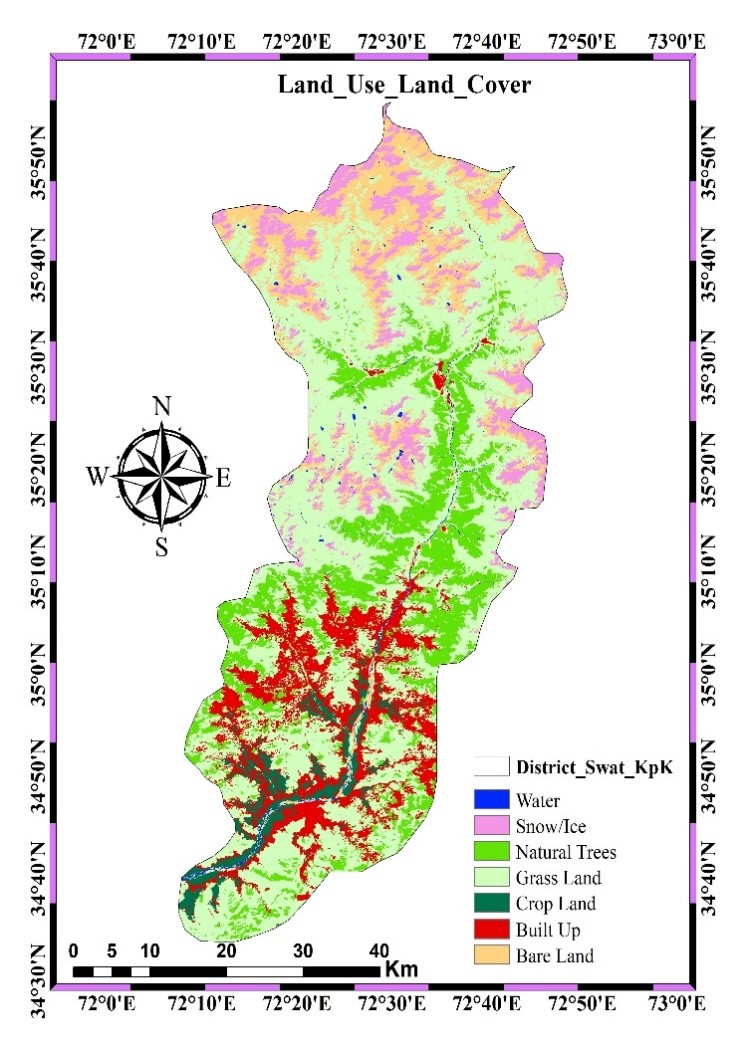
In a world where water is indispensable, Pakistan grapples with the challenge of ensuring its availability. Freshwater demand from domestic, industrial, and agricultural uses has strained the country's reservoirs. Financial and political barriers have hindered the construction of large dams, making it imperative to seek alternative solutions. However, small dams have the potential to address Pakistan's water security concerns. This study uses advanced technology, engineering expertise, socioeconomic factors, and environmental awareness to find multi-purpose small dam sites in Swat District, Pakistan. Water storage and community and economic development are goals. This study examines criteria using RS and GIS. Dam site selection considers rainfall patterns, slopes, land use, soil types, and drainage density. The study uses Elevation Area Capacity (EAC) curves to view potential reservoirs. The map divides areas into High, Moderate, and Low suitability. This analysis yields some sites where R4 is impressive for its suitability and storage capacity of 358,237 at 2080 m. R1 and R2 are promising with moderate suitability and large storage capacities of 121,346 and 271,964, respectively. These sites are more than numbers on a map they represent local aspirations. Their benefits include electricity, flood protection, irrigation, and drinking water. Small dams are progress catalysts with low maintenance and political support. This study concludes that socioeconomic and environmental factors should be considered when engineering small dams. This small dam can store water and provide essential services to local communities and economies. These multi-purpose small dams advance water security.
References
T. Kumar and D. Jhariya, “Identification of Rainwater Harvesting Sites using SCS-CN Methodology, Remote Sensing and Geographical Information System Techniques,” Geocarto Int., vol. 32, pp. 1–43, 2016, doi: 10.1080/10106049.2016.1213772.
R. Agarwal, P. Garg, and R. Garg, “Remote Sensing and GIS Based Approach for Identification of Artificial Recharge Sites,” Water Resour. Manag., vol. 27, 2013, doi: 10.1007/s11269-013-0310-7.
J. Krois and A. Schulte, “GIS-based multi-criteria evaluation to identify potential sites for soil and water conservation techniques in the Ronquillo watershed, northern Peru,” Appl. Geogr., vol. 51, pp. 131–142, 2014, doi: https://doi.org/10.1016/j.apgeog.2014.04.006.
E. Blanc and E. Strobl, “Is Small Better? A Comparison of the Effect of Large and Small Dams on Cropland Productivity in South Africa,” World Bank Econ. Rev., vol. 28, no. 3, pp. 545–576, 2014, doi: 10.1093/wber/lht026.
G. Mugo and P. Odera, “Site selection for rainwater harvesting structures in Kiambu County-Kenya,” Egypt. J. Remote Sens. Sp. Sci., vol. 22, pp. 155–164, 2019, doi: 10.1016/j.ejrs.2018.05.003.
K. Balkhair and K. Rahman, “Development and assessment of rainwater harvesting suitability map using Analytical Hierarchy Process, GIS, and RS techniques,” Geocarto Int., vol. 36, pp. 1–19, 2019, doi: 10.1080/10106049.2019.1608591.
A. Adham, M. Riksen, R. Abed, S. Shadeed, and C. Ritsema, “Assessing Suitable Techniques for Rainwater Harvesting Using Analytical Hierarchy Process ( AHP ) Methods and GIS Techniques,” 2022.
D. Khan, A. Raziq, H. V. Young, T. Sardar, and Y. Liou, “Identifying Potential Sites for Rainwater Harvesting Structures in Ghazi Tehsil , Khyber Pakhtunkhwa , Pakistan , Using,” 2022.
A. Hussain, “Investigating feasible sites for multi _ purpose small dams in Swat District of Khyber Pakhtunkhwa Province , Pakistan : socioeconomic and environmental considerations,” pp. 10852–10875, 2022, doi: 10.1007/s10668-021-01886-z.
M. Kumar, A. Agarwal, and R. Bali, “Delineation of potential sites for water harvesting structures using remote sensing and GIS,” J. Indian Soc. Remote Sens., vol. 36, pp. 323–334, 2008, doi: 10.1007/s12524-008-0033-z.
T. Naseef and R. Thomas, “Identification of Suitable Sites for Water Harvesting Structures in Kecheri River Basin,” Procedia Technol., vol. 24, pp. 7–14, 2016, doi: 10.1016/j.protcy.2016.05.003.
S. Mahmoud and P. Alazba, “The potential of in situ rainwater harvesting in arid regions: developing a methodology to identify suitable areas using GIS-based decision support system,” Arab. J. Geosci., 2014, doi: 10.1007/s12517-014-1535-3.
S. H. Mahmoud and A. A. Alazba, “The potential of in situ rainwater harvesting in arid regions: developing a methodology to identify suitable areas using GIS-based decision support system,” Arab. J. Geosci., vol. 8, no. 7, pp. 5167–5179, 2015, doi: 10.1007/s12517-014-1535-3.
A. Adham et al., “International Soil and Water Conservation Research A GIS-based approach for identifying potential sites for harvesting rainwater in the Western Desert of Iraq,” Int. Soil Water Conserv. Res., vol. 6, no. 4, pp. 297–304, 2018, doi: 10.1016/j.iswcr.2018.07.003.
S. H. M. X. Tang, “Monitoring prospective sites for rainwater harvesting and stormwater management in the United Kingdom using a GIS-based decision support system,” Environ. Earth Sci., pp. 8621–8638, 2015, doi: 10.1007/s12665-015-4026-2.
A. Ochir, D. Boldbaatar, M. Zorigt, T. Solongo, and J. van Genderen, “Site selection for water harvesting ponds using spatial multi criteria analysis in a region with fluctuating climate,” Geocarto Int., vol. 33, pp. 1–33, 2017, doi: 10.1080/10106049.2017.1289563.
M. Shahid, K. Rahman, K. Balkhair, and D. Nabi, “Impact assessment of land use and climate changes on the variation of runoff in Margalla Hills watersheds, Pakistan,” Arab. J. Geosci., vol. 13, 2020, doi: 10.1007/s12517-020-5231-1.
K. Kochhar et al., “Is the Glass Half Empty or Half Full ? Issues in Managing Water Challenges and Policy Instruments,” 2015.
A. Hussain et al., “Observed trends and variability of seasonal and annual precipitation in Pakistan during 1960–2016,” Int. J. Climatol., 2022, doi: 10.1002/joc.7709.
M. Shahid and K. U. Rahman, “Identifying the Annual and Seasonal Trends of Hydrological and Climatic Variables in the Indus Basin Pakistan,” Asia-Pacific J. Atmos. Sci., vol. 57, no. 2, pp. 191–205, 2021, doi: 10.1007/s13143-020-00194-2.
S. Bangash, “Socio-Economic Conditions of Post-Conflict Swat: A Critical Appraisal,” Tigah A J. Peace Dev., vol. 2, no. December, pp. 66–79, 2012.
Atta-ur-Rahman and A. N. Khan, “Analysis of flood causes and associated socio-economic damages in the Hindukush region,” Nat. Hazards, vol. 59, no. 3, pp. 1239–1260, Dec. 2011, doi: 10.1007/S11069-011-9830-8/METRICS.
M. Qasim, K. Hubacek, M. Termansen, and L. Fleskens, “Modelling land use change across elevation gradients in district Swat, Pakistan,” Reg. Environ. Chang., vol. 13, no. 3, pp. 567–581, 2013, doi: 10.1007/s10113-012-0395-1.
A. Zamani, A. Sharifi, S. Felegari, A. Tariq, and N. Zhao, “Agro Climatic Zoning of Saffron Culture in Miyaneh City by Using WLC Method and Remote Sensing Data,” Agric. 2022, Vol. 12, Page 118, vol. 12, no. 1, p. 118, Jan. 2022, doi: 10.3390/AGRICULTURE12010118.
A. S. A.-A. S. A.-H. M. A.-E. M. A.-A. Tariq, “Agricultural Field Extraction with Deep Learning Algorithm and Satellite Imagery,” J. Indian Soc. Remote Sens., vol. v. 50, no. 2, pp. 417-423–2022 v.50 no.2, 2022, doi: 10.1007/s12524-021-01475-7.
H. Waqas et al., “Flash Flood Susceptibility Assessment and Zonation Using an Integrating Analytic Hierarchy Process and Frequency Ratio Model for the Chitral District, Khyber Pakhtunkhwa, Pakistan,” Water 2021, Vol. 13, Page 1650, vol. 13, no. 12, p. 1650, Jun. 2021, doi: 10.3390/W13121650.
F. Islam et al., “Landslide susceptibility mapping (LSM) of Swat District, Hindu Kush Himalayan region of Pakistan, using GIS-based bivariate modeling,” Front. Environ. Sci., vol. 10, no. October, pp. 1–18, 2022, doi: 10.3389/fenvs.2022.1027423.
Z. H. Dahri, B. Ahmad, J. H. Leach, and S. Ahmad, “Satellite-based snowcover distribution and associated snowmelt runoff modeling in Swat River Basin of Pakistan,” Proc. Pakistan Acad. Sci., vol. 48, no. 1, pp. 19–32, 2011.
F. Bazzani, “Atlas of the Natural Resources Evaluation in Swat Valley , Khyber Pakhtunkhwa , Islamic Republic of Pakistan,” no. May, 2013.
S. R. Khan and S. R. Khan, “Assessing poverty-deforestation links: Evidence from Swat, Pakistan,” Ecol. Econ., vol. 68, no. 10, pp. 2607–2618, 2009, doi: 10.1016/j.ecolecon.2009.04.018.
M. S. Bacha, M. Muhammad, Z. Kılıç, and M. Nafees, “The dynamics of public perceptions and climate change in swat valley, khyber pakhtunkhwa, Pakistan,” Sustain., vol. 13, no. 8, pp. 1–22, 2021, doi: 10.3390/su13084464.
A. Sajjad et al., “Application of Remote Sensing and GIS in Forest Cover Change in Tehsil Barawal, District Dir, Pakistan,” Am. J. Plant Sci., vol. 06, no. 09, pp. 1501–1508, 2015, doi: 10.4236/ajps.2015.69149.
T. Adugna, W. Xu, and J. Fan, “Comparison of Random Forest and Support Vector Machine Classifiers for Regional Land Cover Mapping Using Coarse Resolution FY-3C Images,” Remote Sens., vol. 14, no. 3, pp. 1–22, 2022, doi: 10.3390/rs14030574.
K. S. Balkhair and K. Ur Rahman, “Development and assessment of rainwater harvesting suitability map using analytical hierarchy process, GIS and RS techniques,” Geocarto Int., vol. 36, no. 4, pp. 421–448, 2021, doi: 10.1080/10106049.2019.1608591.
Z. K. Motlagh, A. Lotfi, S. Pourmanafi, S. Ahmadizadeh, and A. Soffianian, “Spatial modeling of land-use change in a rapidly urbanizing landscape in central Iran: integration of remote sensing, CA-Markov, and landscape metrics,” Environ. Monit. Assess., vol. 192, no. 11, 2020, doi: 10.1007/s10661-020-08647-x.
B. R. Parida and S. P. Mandal, “Polarimetric decomposition methods for LULC mapping using ALOS L-band PolSAR data in Western parts of Mizoram, Northeast India,” SN Appl. Sci., vol. 2, no. 6, pp. 1–15, 2020, doi: 10.1007/s42452-020-2866-1.
Published
How to Cite
Issue
Section
License
Copyright (c) 2023 50SEA

This work is licensed under a Creative Commons Attribution 4.0 International License.


