
ML/AI Based Flood Mapping in Swat Watershed Using Sentinel-I and Sentinel-II Data
Keywords:
Sentinel-1, Sentinel-2, Flood monitoring, Flood mapping, Water indices, NDWI, WRI, Flood extent, Remote sensing, Multi-sensor approach.Abstract
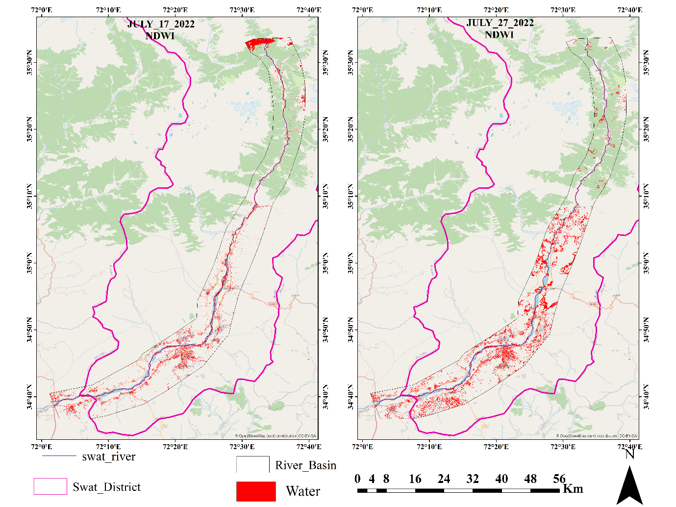
This research uses Sentinel-1 and Sentinel-2 data for flood monitoring and mapping, with a focus on the accuracy and reliability of these remote sensing techniques in identifying flood inundation areas. The objectives of this study revolved around the accuracy and reliability of these techniques in detecting and mapping floodwaters. Water indices, namely NDWI and WRI, were utilized to extract floodwater areas and generate flood inundation maps. Additionally, flood extent maps were generated using Sentinel-1 data to complement the findings from Sentinel-2 data. The study implemented a multi-sensor and multi-index approach, considering both optical and radar data, to provide a comprehensive analysis of flood events. Image selection based on low cloud cover was employed to ensure high-quality and cloud-free imagery for accurate flood extent estimation. The selected images were processed using water indices, NDWI and WRI, which effectively captured the spatial distribution of floodwaters. The results revealed insights into the temporal variation and spatial distribution of flood extents, allowing for the identification of most affected areas. The analysis of Sentinel-2 imagery for July 2022 showcased a progressive intensification of the flood event, with the most affected regions being Charbagh, Mangora, Saidu Sharif, and Chakdara. The flood extents increased in August 2022, affecting areas such as Mangora, Saidu Sharif, Charbagh, Manglor, Barikot, and Chakdara. Furthermore, the flood extent in September 2022 indicated the persistence of floodwaters in areas with relatively fewer sloping surfaces. The integration of Sentinel-1 data provided enhanced comprehension into flood extents, particularly in challenging conditions such as high cloud cover or dense vegetation. The flood inundation maps generated from Sentinel-1 data complemented the findings from Sentinel-2 data, enhancing the accuracy and reliability of flood extent assessments. It is important to note that the high areas observed in the Sentinel-1 flood inundation maps are due to the mosaic of all the images acquired during the respective months. This approach includes all the water detected by Sentinel-1 from the 15 images, resulting in a larger affected area being shown. The flood inundation areas derived from Sentinel-1 data for July, August, and September were 129 km², 431 km², and 66 km², respectively. The analysis of Sentinel-1 data reveals that Kalam, Bahrain, and Madyan are highly vulnerable to intense flooding, as indicated by the high flood levels observed in these regions. The steep terrain, narrow valleys, and high rainfall intensity contribute to the heightened flood risk in these areas. The flood extents in Mangora, Saidu Sharif, and Barikot also reached significant levels, indicating widespread inundation in these regions. Overall, the study demonstrated the effectiveness of Sentinel-1 and Sentinel-2 data in flood monitoring and mapping. The multi-sensor and multi-index approach enhanced the reliability and robustness of the flood extent assessments, enabling better-informed decision-making processes for emergency response planning, resource allocation, and the implementation of effective flood mitigation strategies. The findings highlighted the importance of considering multiple indices and satellite data sources to obtain a comprehensive understanding of flood dynamics, while acknowledging the influence of cloud cover and other factors on the accuracy of the results.
References
R. Sivanpillai, K. M. Jacobs, C. M. Mattilio, and E. V Piskorski, “Rapid flood inundation mapping by differencing water indices from pre- and post-flood Landsat images,” Front. Earth Sci., vol. 15, no. 1, pp. 1–11, 2021, doi: 10.1007/s11707-020-0818-0.
P. Zhang et al., “Hydrodynamic and Inundation Modeling of China’s Largest Freshwater Lake Aided by Remote Sensing Data,” Remote Sens., vol. 7, no. 4, pp. 4858–4879, 2015, doi: 10.3390/rs70404858.
B. Khalid et al., “Riverine flood assessment in Jhang district in connection with ENSO and summer monsoon rainfall over Upper Indus Basin for 2010,” Nat. Hazards, vol. 92, no. 2, pp. 971–993, 2018, doi: 10.1007/s11069-018-3234-y.
A. Refice et al., “SAR and InSAR for flood monitoring: Examples with COSMO/SkyMed data,” Sel. Top. Appl. Earth Obs. Remote Sensing, IEEE J., vol. 7, 2014, doi: 10.1109/JSTARS.2014.2305165.
N. W. Arnell and S. N. Gosling, “The impacts of climate change on river flood risk at the global scale,” Clim. Change, vol. 134, no. 3, pp. 387–401, 2016, doi: 10.1007/s10584-014-1084-5.
S. M. El-Hadidy and S. M. Morsy, “Expected spatio-temporal variation of groundwater deficit by integrating groundwater modeling, remote sensing, and GIS techniques,” Egypt. J. Remote Sens. Sp. Sci., vol. 25, no. 1, pp. 97–111, 2022, doi: https://doi.org/10.1016/j.ejrs.2022.01.001.
D. S. Williams, M. Máñez Costa, L. Celliers, and C. Sutherland, “Informal Settlements and Flooding: Identifying Strengths and Weaknesses in Local Governance for Water Management,” Water, vol. 10, no. 7, 2018, doi: 10.3390/w10070871.
L. Tascón-González, M. Ferrer-Julià, M. Ruiz, and E. García-Meléndez, “Social Vulnerability Assessment for Flood Risk Analysis,” Water, vol. 12, no. 2. 2020. doi: 10.3390/w12020558.
K. Uddin, M. A. Matin, and F. J. Meyer, “Operational Flood Mapping Using Multi-Temporal Sentinel-1 SAR Images: A Case Study from Bangladesh,” Remote Sens., vol. 11, no. 13, 2019, doi: 10.3390/rs11131581.
V. Scotti, M. Giannini, and F. Cioffi, “Enhanced flood mapping using synthetic aperture radar (SAR) images, hydraulic modelling, and social media: A case study of Hurricane Harvey (Houston, TX),” J. Flood Risk Manag., vol. 13, no. 4, p. e12647, Dec. 2020, doi: 10.1111/JFR3.12647.
C. Șerban, C. Maftei, and G. Dobrică, “Surface Water Change Detection via Water Indices and Predictive Modeling Using Remote Sensing Imagery: A Case Study of Nuntasi-Tuzla Lake, Romania,” Water 2022, Vol. 14, Page 556, vol. 14, no. 4, p. 556, Feb. 2022, doi: 10.3390/W14040556.
R. O. Salami, J. K. von Meding, and H. Giggins, “Vulnerability of human settlements to flood risk in the core area of Ibadan metropolis, Nigeria.,” Jamba (Potchefstroom, South Africa), vol. 9, no. 1, p. 371, 2017, doi: 10.4102/jamba.v9i1.371.
J. Serrano, S. Shahidian, and J. M. da Silva, “Evaluation of Normalized Difference Water Index as a Tool for Monitoring Pasture Seasonal and Inter-Annual Variability in a Mediterranean Agro-Silvo-Pastoral System,” Water 2019, Vol. 11, Page 62, vol. 11, no. 1, p. 62, Jan. 2019, doi: 10.3390/W11010062.
Q. Shenming, L. Xiang, and G. Zhihua, “A new hyperspectral image classification method based on spatial-spectral features,” Sci. Reports 2022 121, vol. 12, no. 1, pp. 1–16, Jan. 2022, doi: 10.1038/s41598-022-05422-5.
A. Rahadiati, M. Munawaroh, and E. Suryanegara, “The Impact of Flooding on Settlement Along the Jangkok River Mataram, Indonesia,” IOP Conf. Ser. Earth Environ. Sci., vol. 750, p. 12003, 2021, doi: 10.1088/1755-1315/750/1/012003.
Q. Sholihah, W. Kuncoro, S. Wahyuni, S. Puni Suwandi, and E. Dwi Feditasari, “The analysis of the causes of flood disasters and their impacts in the perspective of environmental law,” IOP Conf. Ser. Earth Environ. Sci., vol. 437, no. 1, p. 012056, Feb. 2020, doi: 10.1088/1755-1315/437/1/012056.
R. Sivanpillai, K. M. Jacobs, C. M. Mattilio, and E. V. Piskorski, “Rapid flood inundation mapping by differencing water indices from pre- and post-flood Landsat images,” Front. Earth Sci., vol. 15, no. 1, pp. 1–11, Mar. 2021, doi: 10.1007/S11707-020-0818-0/METRICS.
Syam’Ani, “Capability of Sentinel-1 Synthetic Aperture Radar polarimetric change detection for burned area extraction in South Kalimantan, Indonesia,” IOP Conf. Ser. Earth Environ. Sci., vol. 500, no. 1, p. 012004, Jun. 2020, doi: 10.1088/1755-1315/500/1/012004.
C. W. J. Tay, S. H. Yun, S. T. Chin, A. Bhardwaj, J. Jung, and E. M. Hill, “Rapid flood and damage mapping using synthetic aperture radar in response to Typhoon Hagibis, Japan,” Sci. Data 2020 71, vol. 7, no. 1, pp. 1–9, Mar. 2020, doi: 10.1038/s41597-020-0443-5.
A. Sharifi, H. Mahdipour, E. Moradi, and A. Tariq, “Agricultural Field Extraction with Deep Learning Algorithm and Satellite Imagery,” J. Indian Soc. Remote Sens., vol. 50, no. 2, pp. 417–423, Feb. 2022, doi: 10.1007/S12524-021-01475-7/METRICS.
K. Uddin, M. A. Matin, and F. J. Meyer, “Operational Flood Mapping Using Multi-Temporal Sentinel-1 SAR Images: A Case Study from Bangladesh,” Remote Sens. 2019, Vol. 11, Page 1581, vol. 11, no. 13, p. 1581, Jul. 2019, doi: 10.3390/RS11131581.
A. Verhegghen et al., “The Potential of Sentinel Satellites for Burnt Area Mapping and Monitoring in the Congo Basin Forests,” Remote Sens. 2016, Vol. 8, Page 986, vol. 8, no. 12, p. 986, Nov. 2016, doi: 10.3390/RS8120986.
W. Nigel, “Integrated river basin management: A case for collaboration,” Int. J. River Basin Manag., vol. 2, no. 4, pp. 243–257, 2004, doi: 10.1080/15715124.2004.9635235.
H. Waqas et al., “Flash Flood Susceptibility Assessment and Zonation Using an Integrating Analytic Hierarchy Process and Frequency Ratio Model for the Chitral District, Khyber Pakhtunkhwa, Pakistan,” Water 2021, Vol. 13, Page 1650, vol. 13, no. 12, p. 1650, Jun. 2021, doi: 10.3390/W13121650.
D. S. Williams, M. M. Costa, L. Celliers, and C. Sutherland, “Informal Settlements and Flooding: Identifying Strengths and Weaknesses in Local Governance for Water Management,” Water 2018, Vol. 10, Page 871, vol. 10, no. 7, p. 871, Jun. 2018, doi: 10.3390/W10070871.
Published
How to Cite
Issue
Section
License
Copyright (c) 2023 50SEA

This work is licensed under a Creative Commons Attribution 4.0 International License.


