
Appraisal of Trans Indus, Marwat-Khisor and Bhittani Ranges Thrusting through Geo-spatial Techniques
Keywords:
Thrusting, Relative Relief, Isobase coding, Drainage density.Abstract
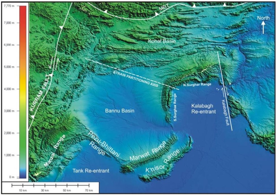
Himalayan mountain belt was created by the Indo–Eurasian collision. The length of this seismically active mountain belt is almost 2500 km. Southern partition of this zone is marked by the main frontal thrust. We computed the isobase, relative relief, incision, vertical dissection and drainage density maps of the study site. Drainage density is inversely proportional to the rest of computed parameters. Drainage density is less where the incision/deep cutting is high. Pezu and north western parts of the study site are observed vulnerable to tectonic activity and high risks. These sites are the adjoining parts of active faults. The rates of morphological changes and the combination of stripping processes are determined through Surface dynamics maps (SDM). Although it is a handy tool used to evaluate erosion conditions of sags or sub basins. Remote sensing and GIS techniques proved efficient for appraisal of thrust in Marwat Kishore and Bhittani ranges.
References
Abbott, L.D., Silver, E.A., Anderson, RS., Smith, R, Ingle J.C., Kling, S.A., Haig, n, Small, E. Galewsky, J" and Sliter, W., Measurement of tectonic surface uplift rate in a young collisional mountain belt: Nature, v. 385, pp: 501-507, 1997.
Ahnert, E, Functional relationships between denudation relief, and uplift in large midlatitude basins: American Journal of Science, v. 268, p. 243-263, 1970.
Anderson, RS., Evolution of the Santa Cruz Mountains, California, through tectonic growth and geomorphic decay: Journal of Geophysical Research, v. 99, issue. B10, pp: 20161-20179, 1994.
Anderson, RS., and Humphrey, N.F, Quantitative Dynamic Stratigraphy: Englewood Cliffs, NJ, PrenticeHall, 1990, pp. 349-361.
Burbank, D. Rates of erosion and their implications for exhumation. Mineralogical Magazine, Vol 66, issue 1, pp: 25-52, 2002.
Blythe, Ann & Burbank, Douglas & Farley, K. & Fielding, Eric.. Structural and topographic evolution of the central Transverse Ranges, California, from apatite fissiontrack, (U-Th)/He and digital elevation model analyses. Basin Research. Vol 12, pp: 97114, 2000.
L.L., and Lillie, RJ., ed., Tectonics and Geophysics of the Western Himalaya, Geological Society of Burbank, Geological society of America, Vol 232, pp: 176-210, 1989.
Burbank, D.W., and Beck, RA.,., Interactions of growing folds and coeval depositional systems: Basin Research, v. 8, issue 1, pp. 199-223.
Gomberg, J.S., Tectonic deformation in the New Madrid seismic zone; inferences from map view and cross sectional boundary element models: Journal of Geophysical Research, v. 98, p. 6639-6664, 1993.
Evans, I. S. Spatial Analysis in Geomorphology. Harper and Row, London, General geomorphometry, derivatives of altitude, and descriptive statistics. In: Chorley, R.J. (Eds.), 1972, pp. 17-90.
Strahler, A. N.: Quantitative analysis of watershed geomorphology. Transactions of the American Geophysical Union Vol 8, issue 6, pp: 913–920, 1957.
Strahler, A.N., “Hypsometric (area-altitude) analysis of erosional topography”, Geological Society America Bulletin, Vol 63, issue 11, pp: 1117-1142, 1952.
Chen, Y.C., Sung, Q. and K.Y. Cheng, “Along-strike variations of morphotectonics features in the Western Foothills of Taiwan: Tectonic implications based on stream gradient and hypsometric analysis”, Geomorphology, Vol 56, issue 1-2, pp: 109-137, 2003.
Published
How to Cite
Issue
Section
License
Copyright (c) 2020 50Sea

This work is licensed under a Creative Commons Attribution 4.0 International License.


