Climate Induced Coastline Changes: A Case Study In Togo (West Africa)
Keywords:
Landsat Images, Coastal Erosion, Remote Sensing, NDWI, Shoreline, Sentinel Images, SVMAbstract
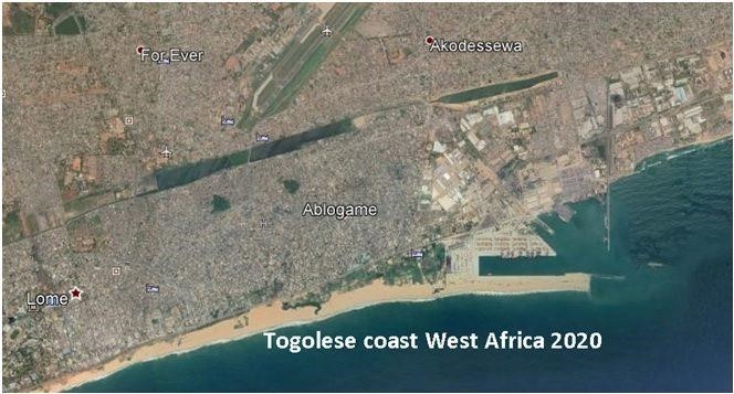
Changing climate is a global distress these days. Global warming is one of the men driven outcome of climate change which causes the glaciers to melt, shoreline regression and raises the level of sea. The regression of shoreline in Togo resulted in vandalization of human habitat and infrastructure. This research aims to monitor the coastal erosion utilizing the geospatial techniques in Togo from 1988 to 2020. The process of extraction and existence of change in shoreline is analyzed. Scientific problems regarding the precision of classification algorithms methods utilized for shoreline extraction using various satellite images are also considered. Thus, NDWI index derived from multisource satellite images were used in this research paper. The performance of Iso Cluster Unsupervised Classification, Otsu threshold segmentation and Sup- port Vector Machine (SVM) Supervised Classification techniques are monitored for the shoreline extraction. This study also takes into account the topographic morphology including non linear and linear coastal surfaces. The rate of change of shoreline was estimated through the statistical linear regression method (LRR). The results demonstrated that the SVM Supervised Classification method worked accurately for topographic morphology than other methods.
References
Deng, H.J., Chen, Y.N., Shi, X., Li, W.H., Wang, H.J., Zhang, S.H. and Fang, G.H. Dynamics of Temperature and Precipitation Extremes and Their Spatial Variation in the Arid Region of Northwest China. Atmospheric Research, 138, 346-355, 2014.
Konko, Y., Bagaram, B., Julien, F., Akpamou, K.G. and Kokou, K. Multi- temporal Analysis of Coastal Erosion Based on Multisource Satellite Images in the South of the Mono Transboundary Biosphere Reserve in Togo (West Africa). Open Access Library Journal, 5, 2018.
Stanchev, H., Young, R. and Stancheva, M. (2013) Integrating GIS and High Resolution Orthophoto Images for the Development of a Geomorphic Shoreline Classification and Risk Assessment: A Case Study of Cliff/Bluff Erosion along the Bulgarian Coast. Journal of Coastal Conservation, 17, 719-728, 2013.
Yang, B., Hwang, C. and Cordell, H.K. Use of LiDAR Shoreline Extraction for Analyzing Revetment Rock Beach Protection: A Case Study of Jekyll Island State Park, USA. Ocean & Coastal Management, 69, 2012.
Bayram, B., Seker, D.Z., Acar, U., Yuksel, Y., Guner, A.H.A. and Cetin, I. An Integrated Approach to Temporal Monitoring of the Shoreline and Basin of Terkos Lake. Journal of Coastal Research, 29, 1427-1435, 2013.
Djagoua, M., Bakayoko, F., Kouadio, M.J., Kassi, A.J.B. and Mobio, A.B.H. Cartography of Coastal Dynamics in Grand-Lahou: Tool Use “Digital Shoreline Analysis System (Dsas)”. European Scientific Journal, 12, 327-335, 2016.
Blivi, A. and Adjoussi, P. La cinématique du trait de côte du Togo vue par télédétection. Geo-Eco-Trop, 28, 27-38, 2004.
Maiti, S. and Bhattacharya, A.K. Shoreline Change Analysis and Its Application to Prediction: A Remote Sensing and Statistics Based Approach. Marine Geol- ogy, 257, 11-23, 2009.
Atsri, H.K., Konko, Y., Cuni-Sanchez, A., Abotsi, K.E. and Kokou, K. Changes in the West African Forest-Savanna Mosaic, Insights from Central PLoS ONE, 13, 2018.
Konko, Contribution of Remote Sensing and GIS to the Integrated Management of Community Forest Resources in the Bas-Mono Valley (South-East Togo), 2016.
Master’s Thesis, Post University Regional School of Integrated Management of Trop- ical Forests and Territories, Kinshasa, Democratic Republic of Congo.
Kalkan, K., Bayram, B., Maktav, D. and Sunar, F. Comparison of SVM and Object Based Classification Methods for Shoreline ISPRS Conference on Serving Society with Geoinformatics, Antalya-Turkey. ISPRS International Archives of the Photogrammetry, Remote Sensing and Spatial Information Sciences, Volume XL-7/W2, 125-127, 2013.
Guariglia, A., Buonamassa, A., Losurdo, A., Saladino, R., Trivigno, M.L. and Zac- cagnino, A. A Multisource Approach for Shoreline Mapping and Identifica- tion of the Shoreline Changes. Annals of Geophysics, 49, 295-304, 2006.
Pardo-Pascual, J.E., Almonacid-Caballer, J., Ruiz, L.A. and Palomar Vázquez, J. (2012) Automatic Extraction of Shorelines from Landsat TM and ETM+ Mul- ti-Temporal Images with Subpixel Remote Sensing of Environment, 123, 1-11, 2012.
Demir, N., Oy, S., Erdem, F., Şeker, D.Z. and Bayram, B. (2017) Integrated Shore- line Extraction Approach with Use of Rasat MS and SENTINEL-1A SAR Images. ISPRS Annals of the Photogrammetry, Remote Sensing and Spatial Information Sciences, 4, 2017.
Bayram, B., Avsar, E.Ö., Seker, D.Z., Kayi, A., Erdogan, M., Eker, O., Janpaule, and Çatal, R.H. The Role of National and International Geospatial Data Sources in Coastal Zone Management. Fresenius Environmental Bulletin, 26, 383-391, 2017.
Wu, H., Liu, C., Zhang, Y. and Sun, W. Water Feature Extraction from Aerial-Image Fused with Airborne LIDAR IEEE Urban Remote Sensing Event, Shanghai, 20-22 May 2009, 1-7, 2009.
Yousef, A. and Iftekhar ud din, K. (2014) Shoreline Extraction from the Fusion of LiDAR DEM Data and Aerial Images Using Mutual Information and Genetic Algo-
2014 International Joint Conference on Neural Networks (IJCNN), Beijing, 1007-1014, 2014. UNESCO (2017) Biosphere Reserves.
Konko, Y., Rudant, J.P., Akpamou, G.K., Noumonvi, K.D. and Kokou, K. Spatio-Temporal Distribution of Southeastern Community Forests in Togo (West Africa). Journal of Geoscience and Environment Protection, 6, 51-65, 2018.
Nimon, P., Issaou, L., Konko, Y. and Kokou, K. Spatio-Temporal Patterns of Rainfall Variability for Wet Season over Togo in West Open Access Library Journal, 7, 2020.
Wang, X., Liu, Y., Ling, F., Liu, and Fang, F. Spatio-Temporal Change Detection of Ningbo Shoreline Using Landsat Time-Series Images during 1976-2015. International Journal of Geo-Information, 6, 68, 2017.
Mcfeeters, S.K. The Use of the Normalized Difference Water Index (NDWI) in the Delineation of Open Water International Journal of Remote Sensing, 17, 1425-1432, 1996.
Mas, J.F. Monitoring Land-Cover Changes: A Comparison of Change Detection Techniques. International Journal of Remote Sensing, 20, 139-152, 1999.

Published
How to Cite
Issue
Section
License
Copyright (c) 2021 50sea

This work is licensed under a Creative Commons Attribution 4.0 International License.


