
Impact of Land-use Change on Agricultural Production & Accuracy Assessment through Confusion Matrix
Keywords:
Landuse; GIS; RS; agricultural production; Shorkot.Abstract
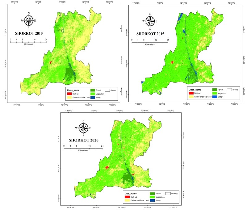
Land modification and its allied resources have progressively become a severe problem presently pulling the worldwide attention and now it rests at the central point of the conservation of the environment and sustainability. The present research aimed to examine the land-use changes and their impact on agricultural production using remote sensing and GIS techniques over the study area that comprised of Tehsil Shorkot, District Jhang, Punjab, Pakistan. Images were pre-processed by using the Arc GIS and ERDAS Imagine 15 software for stacking of the layers, sub-setting, and mosaicking of the satellite bands. After the pre-processing of the images, supervised image classification scheme was applied by employing a maximum likelihood algorithm to recognize the land-use changes which have been observed in the area under study. The area under water was occupied 9.6 km2 in 2010 that increased to 21.04 km2 in 2015 and decreased to 19.4 km2in 2020. Built-up land was 16.6 km2 in 2010 that increased to 19.4 km2 in 2015 and 26.8 km2 in 2020. The total area under vegetation was computed as 513.2 km2 in 2010 that increased to 601.6km2 in 2015 and further increased to 717.7 km2in 2020. Forest land use showed decreasing trend as the covered area in 2010 was occupied 90.8 km2 that decreased to 86.7 km2 in 2015 and further decreased to 61.84 km2 in 2020. In 2010, barren land use was occupied 528.54 km2 that considerably decreased to 429.64 km2 in 2015 further decreased to 333.1 km2 in 2020. Barren land drastically decreased into watered, built-up, and vegetation land uses. The findings of this study will be helpful for the future conservation of various land-use types, urban and regional planning, and an increase in agricultural production of various crops in the study area.
References
A. R. Bock, W. H. Farmer, and L. E. Hay, “Quantifying uncertainty in simulated streamflow and runoff from a continental-scale monthly water balance model,” Adv. Water Resour., vol. 122, pp. 166–175, Dec. 2018, doi: 10.1016/J.ADVWATRES.2018.10.005.
Z. Jiang, A. Sharma, F. Johnson, Z. Jiang, A. Sharma, and F. Johnson, “Assessing the sensitivity of hydro-climatological change detection methods to model uncertainty and bias,” AdWR, vol. 134, p. 103430, Dec. 2019, doi: 10.1016/J.ADVWATRES.2019.103430.
R. John and M. John, “Adaptation of the visibility graph algorithm for detecting time lag between rainfall and water level fluctuations in Lake Okeechobee,” Adv. Water Resour., vol. 134, p. 103429, 2019, doi: 10.1016/j.advwatres.2019.103429.
D. J. Guan, H. F. Li, T. Inohae, W. Su, T. Nagaie, and K. Hokao, “Modeling urban land use change by the integration of cellular automaton and Markov model,” Ecol. Modell., vol. 222, no. 20–22, pp. 3761–3772, Oct. 2011, doi: 10.1016/J.ECOLMODEL.2011.09.009.
M. W. A. Halmy, P. E. Gessler, J. A. Hicke, and B. B. Salem, “Land use/land cover change detection and prediction in the north-western coastal desert of Egypt using Markov-CA,” Appl. Geogr., vol. 63, pp. 101–112, Sep. 2015, doi: 10.1016/J.APGEOG.2015.06.015.
H. W. Zheng, G. Q. Shen, H. Wang, and J. Hong, “Simulating land use change in urban renewal areas: A case study in Hong Kong,” Habitat Int., vol. 46, pp. 23–34, 2015, doi: 10.1016/j.habitatint.2014.10.008.
F. Sedano, V. Molini, and M. A. K. Azad, “A Mapping Framework to Characterize Land Use in the Sudan-Sahel Region from Dense Stacks of Landsat Data,” Remote Sens. 2019, Vol. 11, Page 648, vol. 11, no. 6, p. 648, Mar. 2019, doi: 10.3390/RS11060648.
H. Han, C. Yang, and J. Song, “Scenario Simulation and the Prediction of Land Use and Land Cover Change in Beijing, China,” Sustain. 2015, Vol. 7, Pages 4260-4279, vol. 7, no. 4, pp. 4260–4279, Apr. 2015, doi: 10.3390/SU7044260.
J. Anand, A. K. Gosain, and R. Khosa, “Prediction of land use changes based on Land Change Modeler and attribution of changes in the water balance of Ganga basin to land use change using the SWAT model,” Sci. Total Environ., vol. 644, pp. 503–519, Dec. 2018, doi: 10.1016/J.SCITOTENV.2018.07.017.
D. Guan, X. Lin, W. Gao, W. Su, and K. Hokao, “DYNAMIC EVOLVEMENT ASSESSMENT AND FORECAST OF LAND USE BASED ON GEOGRAPHIC INFORMATION SYSTEM,” Lowl. Technol. Int., vol. 16, no. 1, pp. 36–44, Jun. 2014, doi: 10.14247/LTI.16.1_36.
C. K. M. Ho, T. Jackson, M. T. Harrison, and R. J. Eckard, “Increasing ewe genetic fecundity improves whole-farm production and reduces greenhouse gas emissions intensities: 2. Economic performance,” Anim. Prod. Sci., vol. 54, no. 9, pp. 1248–1253, 2014, doi: 10.1071/AN14309.
M. T. Harrison, J. R. Evans, H. Dove, and A. D. Moore, “Recovery dynamics of rainfed winter wheat after livestock grazing 2. Light interception, radiation-use efficiency and dry-matter partitioning,” Crop Pasture Sci., vol. 62, no. 11, pp. 960–971, 2011, doi: 10.1071/CP11235.
“Simulating Emergent Urban Form Using Agent-Based Modeling: Desakota in the Suzhou-Wuxian Region in China on JSTOR.” https://www.jstor.org/stable/4620285 (accessed Mar. 02, 2022).
M. Mohsin, “Urban Growth and Conversion of Farmland in Bahawalpur City, Pakistan Causes, Rates and Remedies.”
“(PDF) Sprawling Housing Schemes and Loss of Farmland: A Case of Bahawalpur City, Pakistan.” https://www.researchgate.net/publication/284186910_Sprawling_Housing_Schemes_and_Loss_of_Farmland_A_Case_of_Bahawalpur_City_Pakistan (accessed Mar. 02, 2022).
M. Minallah, M. Mohsin, and A. Khan, “Expansion of Residential Colonies and Conversion of Farmland in Bahawalpur City, Pakistan: A Temporal View,” J. Basic Appl. Sci., vol. 12, no. February, pp. 124–134, 2016, doi: 10.6000/1927-5129.2016.12.19.
M. Mohsin and A. A. Khan, “Analysis of the determinants of agricultural land conversion (ALC) into housing colonies in Bahawalpur city, Pakistan,” Pakistan J. Agric. Sci., vol. 54, no. 3, pp. 725–730, Sep. 2017, doi: 10.21162/PAKJAS/17.2643.
“(PDF) Impact of Land Use Change on Land Values: A Case of Jhangiwala, Bahawalpur City, Pakistan.” https://www.researchgate.net/publication/336056901_Impact_of_Land_Use_Change_on_Land_Values_A_Case_of_Jhangiwala_Bahawalpur_City_Pakistan (accessed Mar. 02, 2022).
M. Sahana, R. Ahmed, and H. Sajjad, “Analyzing land surface temperature distribution in response to land use/land cover change using split window algorithm and spectral radiance model in Sundarban Biosphere Reserve, India,” Model. Earth Syst. Environ., vol. 2, no. 2, Jun. 2016, doi: 10.1007/S40808-016-0135-5.
A. S. M. Abdul Athick, K. Shankar, and H. R. Naqvi, “Data on time series analysis of land surface temperature variation in response to vegetation indices in twelve Wereda of Ethiopia using mono window, split window algorithm and spectral radiance model,” Data Br., vol. 27, p. 104773, Dec. 2019, doi: 10.1016/J.DIB.2019.104773.
P. Sinha, L. Kumar, and N. Reid, “Three-date landsat thematic mapper composite in seasonal land-cover change identification in a mid-latitudinal region of diverse climate and land use,” J. Appl. Remote Sens., vol. 6, no. 1, p. 063595, Oct. 2012, doi: 10.1117/1.JRS.6.063595.
M. Almazroui, A. Mashat, M. E. Assiri, and M. J. Butt, “Application of Landsat Data for Urban Growth Monitoring in Jeddah,” Earth Syst. Environ., vol. 1, no. 2, Dec. 2017, doi: 10.1007/S41748-017-0028-4.
R. Bhagyanagar, B. M. Kawal, G. S. Dwarakish, and S. Surathkal, “Land use/land cover change and urban expansion during 1983–2008 in the coastal area of Dakshina Kannada district, South India,” J. Appl. Remote Sens., vol. 6, no. 1, pp. 063576–1, Sep. 2012, doi: 10.1117/1.JRS.6.063576.
Z. Zhang et al., “Mass Change of Glaciers in Muztag Ata–Kongur Tagh, Eastern Pamir, China from 1971/76 to 2013/14 as Derived from Remote Sensing Data,” PLoS One, vol. 11, no. 1, p. e0147327, Jan. 2016, doi: 10.1371/JOURNAL.PONE.0147327.
“(PDF) GIS-Based Change Detection of Coastal Features along Karachi Coast, Pakistan.” https://www.researchgate.net/publication/342624631_GIS-Based_Change_Detection_of_Coastal_Features_along_Karachi_Coast_Pakistan (accessed Mar. 02, 2022).
F. Akhtar, U. K. Awan, B. Tischbein, and U. W. Liaqat, “A phenology based geo-informatics approach to map land use and land cover (2003–2013) by spatial segregation of large heterogenic river basins,” Appl. Geogr., vol. 88, pp. 48–61, Nov. 2017, doi: 10.1016/J.APGEOG.2017.09.003.
A. Y. M. Abdullah, A. Masrur, M. S. Gani Adnan, M. A. Al Baky, Q. K. Hassan, and A. Dewan, “Spatio-Temporal Patterns of Land Use/Land Cover Change in the Heterogeneous Coastal Region of Bangladesh between 1990 and 2017,” Remote Sens. 2019, Vol. 11, Page 790, vol. 11, no. 7, p. 790, Apr. 2019, doi: 10.3390/RS11070790.
S. Hussain et al., “Using GIS tools to detect the land use/land cover changes during forty years in Lodhran District of Pakistan,” Environ. Sci. Pollut. Res. Int., vol. 27, no. 32, pp. 39676–39692, Nov. 2020, doi: 10.1007/S11356-019-06072-3.
M. Hasanuzzaman, “Agronomic crops: Volume 2: Management practices,” Agron. Crop. Vol. 2 Manag. Pract., pp. 1–652, Jan. 2019, doi: 10.1007/978-981-32-9783-8.
M. J. M. Cheema and W. G. M. Bastiaanssen, “Land use and land cover classification in the irrigated Indus Basin using growth phenology information from satellite data to support water management analysis,” Agric. Water Manag., vol. 97, no. 10, pp. 1541–1552, Oct. 2010, doi: 10.1016/J.AGWAT.2010.05.009.
S. Das and R. Sarkar, “Predicting the land use and land cover change using Markov model: A catchment level analysis of the Bhagirathi-Hugli River,” Spat. Inf. Res., vol. 27, no. 4, pp. 439–452, Aug. 2019, doi: 10.1007/S41324-019-00251-7.
J. Tan, D. Yu, Q. Li, X. Tan, and W. Zhou, “Spatial relationship between land-use/land-cover change and land surface temperature in the Dongting Lake area, China,” Sci. Reports 2020 101, vol. 10, no. 1, pp. 1–9, Jun. 2020, doi: 10.1038/s41598-020-66168-6.
B. J. B. Zoungrana et al., “Multi-Temporal Landsat Images and Ancillary Data for Land Use/Cover Change (LULCC) Detection in the Southwest of Burkina Faso, West Africa,” Remote Sens. 2015, Vol. 7, Pages 12076-12102, vol. 7, no. 9, pp. 12076–12102, Sep. 2015, doi: 10.3390/RS70912076.
G. T. Ayele et al., “Time Series Land Cover Mapping and Change Detection Analysis Using Geographic Information System and Remote Sensing, Northern Ethiopia:,” https://doi.org/10.1177/1178622117751603, vol. 11, Jan. 2018, doi: 10.1177/1178622117751603.
H. hc, G. S, L. Srikanth, and H. J. Surendra, “Prioritization of sub-watersheds of the Kanakapura Watershed in the Arkavathi River Basin, Karnataka, India- using Remote sensing and GIS,” https://doi.org/10.1080/24749508.2020.1846841, vol. 5, no. 2, pp. 149–160, 2020, doi: 10.1080/24749508.2020.1846841.
C. Chew, R. Shah, C. Zuffada, G. Hajj, D. Masters, and A. J. Mannucci, “Demonstrating soil moisture remote sensing with observations from the UK TechDemoSat-1 satellite mission,” Geophys. Res. Lett., vol. 43, no. 7, pp. 3317–3324, Apr. 2016, doi: 10.1002/2016GL068189.
M. S. Saleem, S. R. Ahmad, Shafiq-Ur-Rehman, and M. A. Javed, “Impact assessment of urban development patterns on land surface temperature by using remote sensing techniques: a case study of Lahore, Faisalabad and Multan district,” Environ. Sci. Pollut. Res., vol. 27, no. 32, pp. 39865–39878, Nov. 2020, doi: 10.1007/S11356-020-10050-5.
M. Aboelnour, B. A. Engel, M. Aboelnour, and B. A. Engel, “Application of Remote Sensing Techniques and Geographic Information Systems to Analyze Land Surface Temperature in Response to Land Use/Land Cover Change in Greater Cairo Region, Egypt,” J. Geogr. Inf. Syst., vol. 10, no. 1, pp. 57–88, Jan. 2018, doi: 10.4236/JGIS.2018.101003.
“Monitoring urban growth and land use changes using GIS and remote sensing: A case study of Tehsil Burewala. - Free Online Library.” https://www.thefreelibrary.com/Monitoring+urban+growth+and+land+use+changes+using+GIS+and+remote...-a0631021796 (accessed Mar. 02, 2022).
N. T. Huyen, L. H. Tu, V. N. Q. Tram, D. N. Minh, N. D. Liem, and N. K. Loi, “Assessing the impacts of climate change on water resources in the srepok watershed, central highland of Vietnam,” J. Water Clim. Chang., vol. 8, no. 3, pp. 524–534, Sep. 2017, doi: 10.2166/WCC.2017.135.
R. Kharazmi, A. Tavili, M. R. Rahdari, L. Chaban, E. Panidi, and J. Rodrigo-Comino, “Monitoring and assessment of seasonal land cover changes using remote sensing: a 30-year (1987–2016) case study of Hamoun Wetland, Iran,” Environ. Monit. Assess., vol. 190, no. 6, Jun. 2018, doi: 10.1007/S10661-018-6726-Z.
M. Romaguera, R. G. Vaughan, J. Ettema, E. Izquierdo-Verdiguier, C. A. Hecker, and F. D. van der Meer, “Detecting geothermal anomalies and evaluating LST geothermal component by combining thermal remote sensing time series and land surface model data,” Remote Sens. Environ., vol. 204, pp. 534–552, Jan. 2018, doi: 10.1016/J.RSE.2017.10.003.
S. Pal and S. Ziaul, “Detection of land use and land cover change and land surface temperature in English Bazar urban centre,” Egypt. J. Remote Sens. Sp. Sci., vol. 20, no. 1, pp. 125–145, Jun. 2017, doi: 10.1016/J.EJRS.2016.11.003.
“(PDF) Impact of land use change on water quality of Jhang District Punjab, Pakistan.” https://www.researchgate.net/publication/334251012_Impact_of_land_use_change_on_water_quality_of_Jhang_District_Punjab_Pakistan (accessed Mar. 02, 2022).
M. Rani et al., “Multi-temporal NDVI and surface temperature analysis for Urban Heat Island inbuilt surrounding of sub-humid region: A case study of two geographical regions,” Remote Sens. Appl. Soc. Environ., vol. 10, pp. 163–172, Apr. 2018, doi: 10.1016/J.RSASE.2018.03.007.
M. T. U. Rahman et al., “Temporal dynamics of land use/land cover change and its prediction using CA-ANN model for southwestern coastal Bangladesh,” Environ. Monit. Assess., vol. 11, no. 189, pp. 1–18, Oct. 2017, doi: 10.1007/S10661-017-6272-0.
D. P. Nayak and M. H. Fulekar, “Coastal Geomorphological and Land Use and Land Cover Study on Some Sites of Gulf of Kachchh, Gujarat, West Coast of India using Multi-Temporal Remote Sensing Data,” Int. J. Adv. Remote Sens. GIS, vol. 6, no. 1, pp. 2192–2203, Jun. 2017, doi: 10.23953/CLOUD.IJARSG.273.
D. Wang, X. Yu, G. Jia, and H. Wang, “Sensitivity analysis of runoff to climate variability and land-use changes in the Haihe Basin mountainous area of north China,” Agric. Ecosyst. Environ., vol. 269, pp. 193–203, Jan. 2019, doi: 10.1016/J.AGEE.2018.09.025.
W. Y. Yan, A. Shaker, and N. El-Ashmawy, “Urban land cover classification using airborne LiDAR data: A review,” Remote Sens. Environ., vol. 158, pp. 295–310, Mar. 2015, doi: 10.1016/J.RSE.2014.11.001.
M. Sajid, M. Mobeen, T. Aziz, N. Kanwal, A. Rehman, and M. Rauf, “IMPACT OF LAND USE CHANGE ON AGRICULTURE PRODUCTION OF MULTAN DISTRICT. (A CASE STUDY),” Sci.Int.(Lahore), vol. 32, no. 6, pp. 705–710, 2020, Accessed: Mar. 02, 2022. [Online]. Available: http://glovis.usgs.gov/.
Published
How to Cite
Issue
Section
License
Copyright (c) 2022 50Sea

This work is licensed under a Creative Commons Attribution 4.0 International License.


