
Evaluation of Tectonic Geomorphology of Awaran in Baluchistan, Pakistan using SRTM Data
Keywords:
Awaran Earthquake, Surface dynamic maps, SRTM DEM, Awaran Fault, Isobase Map.Abstract
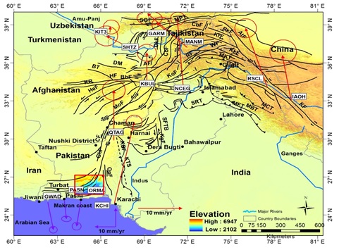
An earthquake of September 24, 2013 with a magnitude of 7.7Mw destroyed extensive region of Awaran district located in province Baluchistan in southern Pakistan, the earthquake was nearly 10km deep below the surface of earth. This convulsion brought a havoc in the inaccessible and remote regions and victimized nearly 810 families. This tremor destroyed the non-engineered human structure within 100 km of the earthquake which caused tremendous loss of human lives. In this paper Digital elevation model (DEM) was utilized to study active deformation and mapped the isobase, relative relief, drainag density incision and vertical dissections which indicates that Awaran Fault sinisterly active in NNE-SSW direction and the deformations were highlighted. The high value of drainage density was observed on northern east and in the central region of southern west region of Awaran district. The drainage density is elevated by accelerated erosion in surrounding region. DEM and remote sensing tools proved efficient to study the region efficiently.
References
Altamimi, Z., X. Collilieux, J. Legrand, B. Garayt, and C. Boucher, A new release of the International Terrestrial Reference Frame based on time series of station positions and Earth Orientation Parameters. Journal of Geophysical Research, Vol 112, 2007.
Apel, E., R. Burgmann, P. Bannerjee, and B. Nagarajan, Geodetically constrained Indian plate mo- tion and implications for plate boundary deforma- tion, Eos Trans. AGU, Vol 87, issue 52, pp: T51B-1524, 2006.
Ambraseys, N., and R. Bilham, Earthquakes and associated deformation in Northern Baluchistan 1892–2001, Bull. Seismol. Soc. Am., Vol 93, issue 4, pp: 1573–1605, 2003.
Atkinson, G.M., An Overview of Developments in Seismic Hazard Analysis. Proceedings of the 13th World Conference on Earthquake Engineering, Vancouver, 2004.
Ambraseys, N., and R. Bilham, Earthquakes and associated deformation in northern Baluchistan, Bull. Seismol. Soc. Am., Vol 93, pp: 1573 – 1605, 2003.
Bender, F. K., and H. A. Raza (Eds.), Geology of Pakistan, Beitr. Reg. Geol. Erde, vol. 25, pp: 414, 1995.
Banks, C. J., and J. Warburton (1986), ‘Passive-roof’ duplex geometry in the frontal structures of the Kirthar and Sulaimanmountain belts, Pakistan, J. Struct. Geol., Vol 8, pp: 229 – 237, 1986.
Bernard, M., B. Shen-Tu, W. E. Holt, and D. M. Davis (2000), Kinematics of active deformation in the Su- laiman lobe and range, Pakistan, J. Geophys. Res., Vol 105, issue 13, pp: 253–13,279, 2000.
Bullard, E.C., Everett, J.E. & Smith, A.G., The fit of the continents around the Atlantic, Phil. Trans. R. Soc. London, Ser. A., Vol 258, pp: 41–51, 1965.
Bilham, R. Earthquakes in India and the Himalaya: tectonics, geodesy and history. Annals of Geophysics, Vol 47, pp: 839–858, 2004.
Beun, N., P. Border, and I. Carbonnel, Premieres donneesquantitatives relative au coulissage du crochement de Chaman, Afghanistan du sud-est, C. R. Seances Acad. Sci., Ser. D, Vol 288, pp: 931–934, 1979.
Bannert, D., A. Cheema, A. Ahmed, and U. Schaffer, The structural development of the western fold belt, Pakistan, Geol. Jahrb., Reihe B, Vol 80, pp: 60, 1992.
Griesbach, C. L. On the geology of the country between chappar Rift and Harnai in Baluchistan. Geological Survey of India, Vol 26, pp: 113-147, 1893.
Garcia, M. E.,W. Szeliga, and R. Bilham, Modeling vertical deformation associated with the 1931 Mach earthquake, Pakistan, Eos Trans. AGU, Vol 87, issue 52, 2006.
Haq, S. S. B., and D. M. Davis, Oblique con- vergence and the lobate mountain belts of western Pakistan, Geology, 25, 23–26, 1997.
Howard, A.D., Dietrich, W.E., and Seidl, M.A., Modeling fluvial disintegration on provincial to mainland scales: Journal of Geophysical Research, v. 99, pp. 13 971–13 986, 1994.
Howard, A.D., Dietrich, W.E., and Seidl, M.A., Modeling fluvial erosion on regional to continental scales: Journal of Geophysical Research, vol 99, pp: 13 971–13 986, 1994.
Ahmad. I, Waqar. A, et al., “Evaluating Focal Mechanism Of September 24, 2013 Awaran Earthquake With Geospatial Techniques”. International Journal of Innovations in Science & Technology, Vol 02 Issue 03: pp 108-124, 2020.
Jackson, J., and D. McKenzie, Active tectonics of the Alpine-Himalayan Belt between Turkey and Pakistan. Geophysical Journal of the Royal Astronomical Society, Vol 77, issue 1, pp: 185–264, 1984.
Kazmi, A. H., Active Fault system in Pakistan. In: Farah, A.& DeJong, K. A. (eds.) Geodynamics of Pakistan. Geology Survey of Pakistan, Queta, pp: 333-340, 1979.
Lawrence, R. D., R. S. Yeats, S. H. Khan, A. Farah, and K. A. DeJong, Thrust and strike slip fault interaction along the Chaman transform zone, Pakistan, Geol. Soc. London Spec. Publ., Vol 9, pp: 363–370, 1981.
Lawrence, R. D., Khan, S. H. and Nakata, T., Chaman Fault, Pakistan- Afghanistan. AnnalesTectonicae, Vol 6, pp: 196– 223, 1999.
Lawrence, R. D., S. H. Khan, and T. Nakata, Chaman fault, Pakistan-Afghanistan, Ann. Tectonicae, Vol 6, pp: 196–223, 1922.
Lawrence, R. D., S. H. Khan, and T. Nakata, Chaman fault, Pakistan-Afghanistan, Ann. Tectonicae, Vol 6, pp: 196–223, 1992.
Kazmi, A.H. and Rana, R.A. Tectonic Map of Pakistan, Geological Survey of Pakistan, 1982.
Lawrence, R .D. and Yeats, R. S. Geological reconnaissance of the Chaman fault in Pakistan. In: Farah. A. &Dejong. K.A. (eds) Geodynamics of Pakistan, 1979.
Molnar, P., and Tapponnier, P. Cenozoic tectonics of Asia: Effects of a continental collision, Science, Vol 189, issue 4201, pp: 419– 426, 1975.
Molnar, P., and J. M. Stock, Slowing of India’s convergence with Eurasia since 20 Ma and its im- plications for Tibetan mantle dynamics, Tectonics, Vol 28, 2009.
Oldhem T. A catalugue of indian earthquakes from the earlieat time to the end of A D 1869. Memoirs of the Geological Survey of India, Vol 19, issue 3, pp: 163-215, 1982.
Oldham, R. The Cutch (Kutch) earthquake of the 16th june 1819 with the revision of the great earthquake of the 12 june 1897. Memoirs of the Geological Survey of India, vol46, pp: 163- 213, 1926.
Power, E. O. F., & Subprojects, t. Quetta electric supply company for augmentation & extension of power transformer subprojects, 2013.
Quittmeyer, R. C., Farah, A. and Jacob, K. H. The seismicity of Pakistan and the relation to surface faults. In: Farah, A. and Dejong, K. A. (eds.) Geodynamics of Pakistan. Geological Survey of Pakistan, Quetta, pp: 351-358, 1979.
Szeliga, W. M., Historical and modern seismotectonics of the Indian plate with an emphasis on its western boundary with the Eurasian plate, 2010.
Szeliga, W., R. Bilham, D. M. Kakar, and S. H. Lodi (2012), Interseismic strain accumulation along thewestern boundary of the Indian subcontinent, J. Geophys. Vol 117, 2012.
Sarwar, F., Iqbal, S., Qaisar, M., Rehman, A., Akhtar, F., & Raza, S. M. Earthquake Statistics and Earthquake Research Studies in Pakistan, (May), pp: 97–104, 2016.
Schelling, D., Structural geology of the Bolan block, western Pakistan, Tech. Rep. 5-20885-99, Energy and Geosci. Inst., Univ. of Utah, Salt Lake City, 1999.
Treloar, P. J., and Coward M. P., Indian plate motion and shape: constraints on the geometry of the Himalayan orogeny. Tectonophysics, Vol 191, pp: 189–198, 1991.
Published
How to Cite
Issue
Section
License
Copyright (c) 2021 50Sea

This work is licensed under a Creative Commons Attribution 4.0 International License.


