
Impact of Different Feature Engineering Techniques for Better Classification of Diverse Crops with Sentinel-2 Imagery
DOI:
https://doi.org/10.33411/ijist/20257320002012Keywords:
Feature Engineering, Multispectral, Temporal resolution, Random forest, Gradient boosting classifierAbstract
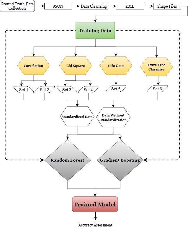
Observing a large area of Earth's surface using remote sensing has made our work very easy in order to monitor changes. This revolutionary tech can help us make big decisions on time. For this purpose, Sentinel-2 imagery is considered to be perfect since the imagery provided by this satellite is easily available https://scihub.copernicus.eu/ website. The European Space Agency (ESA) and the European Union (EU) have created the Copernicus Program, which includes the Sentinel-2 satellites that use onboard multispectral scanners to effectively monitor the Earth’s surface. This program has contributed significantly to the production of Sentinel-2 multispectral products, which provide high-resolution satellite data for monitoring land cover and use. The Sentinel-2 constellation is the second set of satellites in the ESA Sentinel missions, with the primary goal of land cover/use monitoring. Besides the availability of imagery, Sentinel-2 temporal resolution is 5 days, which helps in quick observation. In this manuscript, we have used different feature engineering techniques on our dataset in order to observe their performance and importance for better classification of diverse crops. We have achieved an overall accuracy of 99% after extracting important information from the dataset and applying a random forest and a gradient boosting classifier. The data set used for this research work was collected by surveying diverse crops in the region of Harichand, which is located North-South of Charsada District in Khyber-Pakhtunkhwa, Pakistan. The detailed Explanation of our Work and proposed methods is discussed in this article.
References
S. F. . Abbas Ali Chandio, Habibullah Magsi, “Types, Sources and Importance of Agricultural Credits in Pakistan,” J. Appl. Environ. Biol. Sci., vol. 7, no. 3, pp. 144–149, 2017, [Online]. Available: https://www.researchgate.net/publication/314255675_Types_Sources_and_Importance_of_Agricultural_Credits_in_Pakistan
M. M. K. Muhammad Usman Liaqat, Muhammad Jehanzeb Masud Cheema a, Wenjiang Huang, Talha Mahmood, Muhammad Zaman, “Evaluation of MODIS and Landsat multiband vegetation indices used for wheat yield estimation in irrigated Indus Basin,” Comput. Electron. Agric., vol. 138, pp. 39–47, 2017, doi: https://doi.org/10.1016/j.compag.2017.04.006.
J. P. et al M. Wojtowicz, A. Wojtowicz, “Application of remote sensing methods in agriculture,” Commun. Biometry Crop Sci., vol. 11, no. 1, pp. 31–50, 2016, [Online]. Available: https://www.researchgate.net/publication/290494859_Application_of_remote_sensing_methods_in_agriculture
C. Atzberger, “Advances in Remote Sensing of Agriculture: Context Description, Existing Operational Monitoring Systems and Major Information Needs,” Remote Sens, vol. 5, no. 2, pp. 949–981, 2013, doi: https://doi.org/10.3390/rs5020949.
J. D. Nanshan You, “Examining earliest identifiable timing of crops using all available Sentinel 1/2 imagery and Google Earth Engine,” ISPRS J. Photogramm. Remote Sens., vol. 161, pp. 109–123, 2020, doi: https://doi.org/10.1016/j.isprsjprs.2020.01.001.
M. G. D. Dennis C. Duro, Steven E. Franklin, “A comparison of pixel-based and object-based image analysis with selected machine learning algorithms for the classification of agricultural landscapes using SPOT-5 HRG imagery,” Remote Sens. Environ., vol. 118, pp. 259–272, 2012, doi: https://doi.org/10.1016/j.rse.2011.11.020.
M. Aslam, “Agricultural Productivity Current Scenario, Constraints and Future Prospects in Pakistan,” Sarhad J. Agric., vol. 32, no. 4, pp. 289–303, Oct. 2016, doi: 10.17582/JOURNAL.SJA/2016.32.4.289.303.
Z. Yi, L. Jia, and Q. Chen, “Crop Classification Using Multi-Temporal Sentinel-2 Data in the Shiyang River Basin of China,” Remote Sens. 2020, Vol. 12, Page 4052, vol. 12, no. 24, p. 4052, Dec. 2020, doi: 10.3390/RS12244052.
W. Y. Yan, A. Shaker, and N. El-Ashmawy, “Urban land cover classification using airborne LiDAR data: A review,” Remote Sens. Environ., vol. 158, pp. 295–310, Mar. 2015, doi: 10.1016/J.RSE.2014.11.001.
C. O. T. Kenneth D. Roe, Vibhu Jawa, Xiaohan Zhang, Christopher G. Chute, Jeremy A. Epstein, Jordan Matelsky, Ilya Shpitser, “Feature engineering with clinical expert knowledge: A case study assessment of machine learning model complexity and performance,” PLoS One, 2020, doi: https://doi.org/10.1371/journal.pone.0231300.
R. Saidi, W. Bouaguel, and N. Essoussi, “Hybrid Feature Selection Method Based on the Genetic Algorithm and Pearson Correlation Coefficient,” Stud. Comput. Intell., vol. 801, pp. 3–24, 2019, doi: 10.1007/978-3-030-02357-7_1.
Downloads
Published
How to Cite
Issue
Section
License
Copyright (c) 2025 50sea

This work is licensed under a Creative Commons Attribution 4.0 International License.


