
UAV-Based Flood Mapping and Damage Assessment in Harnai Khawar, Swat, Khyber Pakhtunkhwa, Pakistan
Keywords:
Flood Assessment, UAV Imagery, Swat Basin, Aerial Photogrammetry, GNSS, GIS, Disaster ManagementAbstract
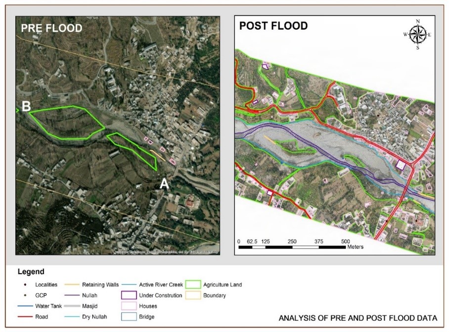
Floods is among the most destructive hydrological hazards in Pakistan, particularly across the steep, data‑sparse basins of Khyber Pakhtunkhwa (KPK). The 2022 monsoon produced catastrophic damage in the Swat Valley, disrupting transport, irrigation, and housing. This article demonstrates an Unmanned Aerial Vehicle (UAV) workflow for rapid, high‑resolution flood mapping, damage quantification, and risk zonation in the Barwai Khwar sub‑watershed of the Swat River Basin. Pre‑event context was assembled from Google Earth Pro imagery (12 June 2022), and post‑event aerial surveys were flown using a DJI Phantom 4 Pro (v2.0) with GNSS‑supported Ground Control Points (GCPs). Imagery was processed in Agi soft Meta shape to generate Ortho mosaics and surface products, then analyzed in a GIS to delineate inundation, channel widening, structural damage, and agricultural losses. The floodplain width locally expanded from approximately 7 m to 76 m; damaged linear infrastructure includes ~2.18 km of retaining walls and 39 m of bridges. Surface impacts include ~6,271 m² of residential area and ~22.56 ha of cropland affected. The approach provided near‑centimeter spatial detail, enabling precise polygonal accounting for recovery planning and identification of high‑risk margins where unprotected construction coincides with steep banks and tight meanders. Findings confirm the value of UAV photogrammetry as a fast, replicable, and cost‑effective complement to satellite‑based disaster assessment in Pakistan’s mountain valleys, supporting preparedness, reconstruction, and resilient land‑use decisions.
References
S. A. Ahmed, K., Ullah, S., & Khan, “Event Analysis: 2022 Floods in Swat Valley, Pakistan,” Reliefweb, 2023, [Online]. Available: https://reliefweb.int/report/pakistan/event-analysis-2022-floods-swat-valley-pakistan
M. Aslam, “Flood Management Current State, Challenges and Prospects in Pakistan: A Review,” Mehran Univ. Res. J. Eng. Technol., vol. 37, no. 2, 2018, [Online]. Available: https://publications.muet.edu.pk/index.php/muetrj/article/view/199
N. A. Bazai et al., “Dynamics and impacts of monsoon-induced geological hazards: A 2022 flood study along the Swat River in Pakistan,” Nat. Hazards Earth Syst. Sci., vol. 25, no. 3, pp. 1071–1093, Mar. 2025, doi: 10.5194/NHESS-25-1071-2025.
K. Calvin et al., “IPCC, 2023: Climate Change 2023: Synthesis Report. Contribution of Working Groups I, II and III to the Sixth Assessment Report of the Intergovernmental Panel on Climate Change [Core Writing Team, H. Lee and J. Romero (eds.)]. IPCC, Geneva, Switzerland.,” Jul. 2023, doi: 10.59327/IPCC/AR6-9789291691647.
I. Elkhrachy, “Flash Flood Hazard Mapping Using Satellite Images and GIS Tools: A case study of Najran City, Kingdom of Saudi Arabia (KSA),” Egypt. J. Remote Sens. Sp. Sci., vol. 18, no. 2, pp. 261–278, 2015, doi: https://doi.org/10.1016/j.ejrs.2015.06.007.
L. Hashemi-Beni, J. Jones, G. Thompson, C. Johnson, and A. Gebrehiwot, “Challenges and Opportunities for UAV-Based Digital Elevation Model Generation for Flood-Risk Management: A Case of Princeville, North Carolina,” Sensors, vol. 18, no. 11, p. 3843, 2018, doi: https://doi.org/10.3390/s18113843.
N. A. Khan et al., “Flood risk assessment in the Swat river catchment through GIS-based multi-criteria decision analysis,” Front. Environ. Sci, vol. 13, 2025, doi: https://doi.org/10.3389/fenvs.2025.1567796.
K. R. Krishna, “Agricultural Drones A Peaceful Pursuit,” Routledge, 2018, [Online]. Available: https://www.routledge.com/Agricultural-Drones-A-Peaceful-Pursuit/Krishna/p/book/9781774636428?srsltid=AfmBOorg0c8AHJ21NhBoPiSUB-4cmcdx-0FifTWhsHqC1qQ42yP-u1QA
Y. L. Wenning Li, “Urban Water Extraction with UAV High-Resolution Remote Sensing Data Based on an Improved U-Net Model,” Remote Sens, vol. 13, no. 16, p. 3165, 2021, doi: https://doi.org/10.3390/rs13163165.
T. E. F. and F. P. Stephanie Long, “Flood extent mapping for Namibia using change detection and thresholding with SAR,” Environ. Res. Lett., vol. 9, no. 3, 2014, doi: 10.1088/1748-9326/9/3/035002.
H. A. & N. K. Sadia Mariam Malik, “Mapping vulnerability to climate change and its repercussions on human health in Pakistan,” Global. Health, vol. 8, 2012, doi: https://doi.org/10.1186/1744-8603-8-31.
J. Zawadzka, I. Truckell, A. Khouakhi, and M. Rivas Casado, “Detection of Flood Damage in Urban Residential Areas Using Object-Oriented UAV Image Analysis Coupled with Tree-Based Classifiers,” Remote Sens., vol. 13, no. 19, p. 3913, 2021, doi: https://doi.org/10.3390/rs13193913.
S. Zakaria, M. R. Mahadi, A. F. Abdullah, and K. Abdan, “Aerial Platform Reliability for Flood Monitoring Under Various Weather Conditions: A Review,” Lect. Notes Geoinf. Cartogr., pp. 295–314, 2019, doi: 10.1007/978-3-030-05330-7_12.
L. Wouters, A. Couasnon, M. C. De Ruiter, M. J. C. Van Den Homberg, A. Teklesadik, and H. De Moel, “Improving flood damage assessments in data-scarce areas by retrieval of building characteristics through UAV image segmentation and machine learning - A case study of the 2019 floods in southern Malawi,” Nat. Hazards Earth Syst. Sci., vol. 21, no. 10, pp. 3199–3218, Oct. 2021, doi: 10.5194/NHESS-21-3199-2021.
Downloads
Published
How to Cite
Issue
Section
License
Copyright (c) 2025 50sea

This work is licensed under a Creative Commons Attribution 4.0 International License.


