
Hydraulic Modelling of Flood Assessment in Chenab Basin Pakistan
Abstract
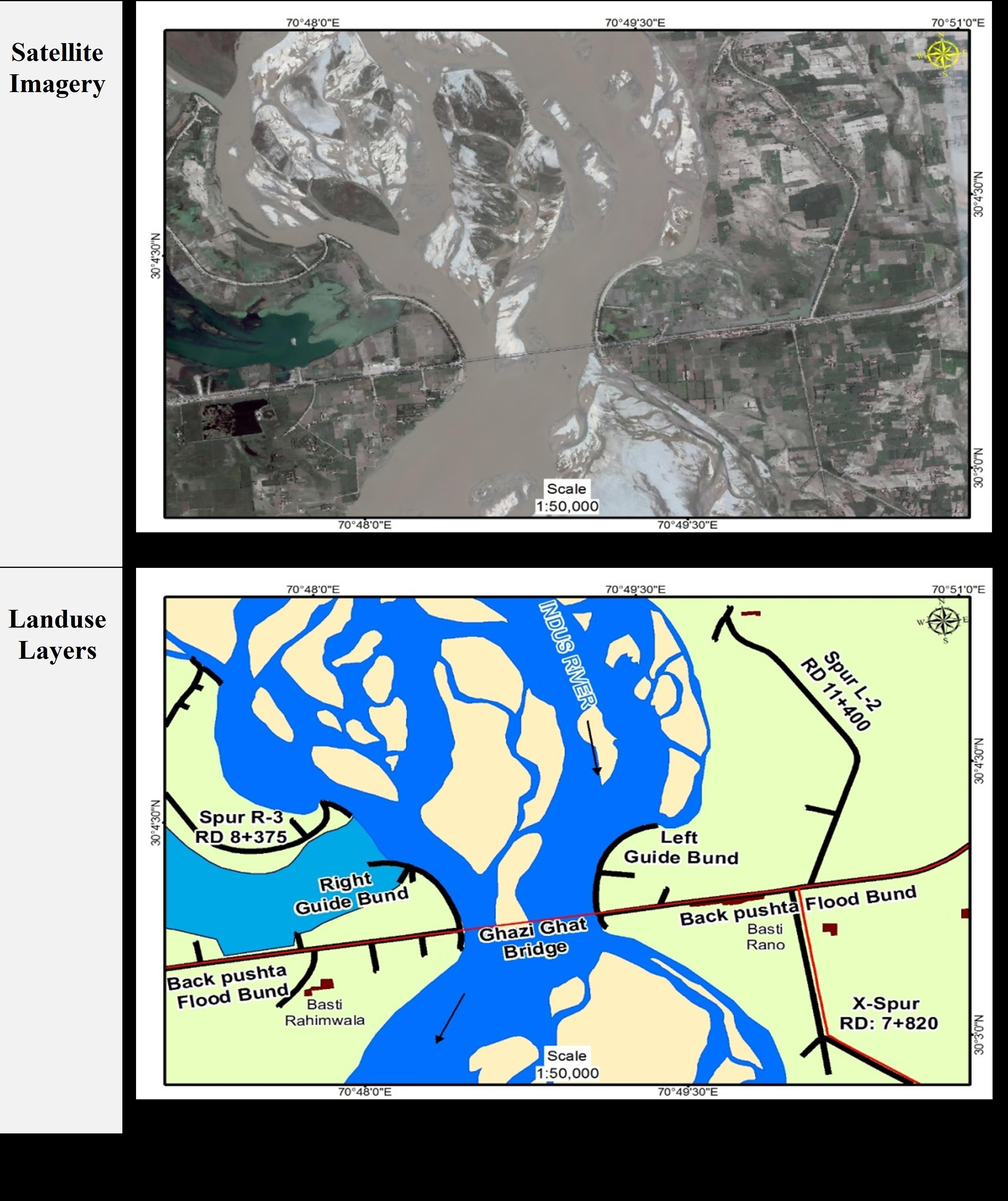
Flooding represents one of the most recurrent and economically damaging natural hazards in Pakistan, particularly within the Indus River system, where extensive floodplains and dense human settlement exacerbate vulnerability. This study presents an integrated flood-assessment framework combining optical remote sensing, geographic information systems (GIS), and physically based hydraulic modelling to delineate and quantify flood inundation in the Chenab Basin, Punjab. Multi-temporal Landsat 8 OLI imagery acquired during pre-, peak-, and post-flood stages was processed to derive the Normalized Difference Water Index (NDWI), Modified NDWI (MNDWI), and Water Ratio Index (WRI) for flood detection. Comparative accuracy assessment using field observations and high-resolution reference imagery demonstrated that MNDWI outperformed other indices, achieving an overall accuracy of 91% compared to 83% for NDWI and 85% for WRI. Supervised maximum-likelihood land-use/land-cover (LULC) classification yielded an overall accuracy of 91.6% with a Kappa coefficient of 0.89, confirming strong agreement between classified outputs and ground reference data. A 30 m SRTM-derived Digital Terrain Model was employed to develop a one-dimensional hydraulic model in HEC-RAS, simulating flood scenarios for return periods ranging from 2.5 to 100 years (455,000–1,665,000 cusecs) along the Chenab River reach between Head Trimmu and Head Panjnad. Modelled water-surface elevations showed close correspondence with GPS-recorded flood marks, with positional deviations below 50 m and sensitivity analysis indicating a maximum ±0.15 m variation in water level for ±0.01 changes in Manning’s roughness coefficient. Results indicate that approximately 68% of the study area was inundated during the 2010 flood, with cropland accounting for nearly 61% of the affected area and settlements for 18%. The integration of satellite-derived water indices with hydraulic simulation proved effective for accurate flood delineation and hazard zoning, providing a robust and operationally scalable framework for flood-risk assessment and spatial planning in data-scarce river basins of Pakistan.
References
Abdulrahman Mohsin, Asif Z. Warsi, “A GEOGRAPHICAL VIEW OF PAKISTAN’S RIVER SYSTEMS AND ITS EFFECTS ON CLIMATE CHANGE,” ResearchGate, 2025, [Online]. Available. https.//www.researchgate.net/publication/388224364_A_GEOGRAPHICAL_VIEW_OF_PAKISTAN’S_RIVER_SYSTEMS_AND_ITS_EFFECTS_ON_CLIMATE_CHANGE
L. Del Rio Amador, M. Boudreault and D. A. Carozza, “Projecting climate and socioeconomic contributions to global flood-induced displacements using a data-driven approach,” Nat. Hazards, vol. 121, no. 14, pp. 16935–16973, Aug. 2025, doi. 10.1007/S11069-025-07457-Z/FIGURES/11.
Ali A, “Indus Basin Floods. Mechanisms, Impacts and Management,” Asian Dev. Bank, 6 ADB Ave. Mandaluyong City 1550 Metro Manila, Philipp., Oct. 2013, doi. 10.22/JS/JQUERY.DATATABLES.MIN.JS.
N. W. Arnell and S. N. Gosling, “The impacts of climate change on river flood risk at the global scale,” Clim. Change, vol. 134, no. 3, pp. 387–401, 2016, doi. 10.1007/s10584-014-1084-5.
S. Mahmood and R. Rani, “People-centric geo-spatial exposure and damage assessment of 2014 flood in lower Chenab Basin, upper Indus Plain in Pakistan,” Nat. Hazards, vol. 111, no. 3, pp. 3053–3069, Apr. 2022, doi. 10.1007/S11069-021-05167-W/METRICS.
J. Sanyal and X. X. Lu, “Application of remote sensing in flood management with special reference to monsoon Asia. A review,” Nat. Hazards, vol. 33, no. 2, pp. 283–301, Oct. 2004, doi. 10.1023/B.NHAZ.0000037035.65105.95/METRICS.
M. S. Rahman and L. Di, “The state of the art of spaceborne remote sensing in flood management,” Nat. Hazards, vol. 85, no. 2, pp. 1223–1248, Jan. 2017, doi. 10.1007/S11069-016-2601-9/METRICS.
M. A. R. Md Atiqur Rahman Khan, “DEVELOPMENT OF A FOG COMPUTING-BASED REAL-TIME FLOOD PREDICTION AND EARLY WARNING SYSTEM USING MACHINE LEARNING AND REMOTE SENSING DATA,” J. Sustain. Dev. Policy, vol. 1, no. 1, 2025, doi. 10.63125/6y0qwr92.
Atta-ur-Rahman and A. N. Khan, “Analysis of 2010-flood causes, nature and magnitude in the Khyber Pakhtunkhwa, Pakistan,” Nat. Hazards, vol. 66, no. 2, pp. 887–904, Mar. 2013, doi. 10.1007/S11069-012-0528-3/METRICS.
M. A. M. Kabir Uddin, “Operational Flood Mapping Using Multi-Temporal Sentinel-1 SAR Images. A Case Study from Bangladesh,” Remote Sens, vol. 11, no. 13, p. 1581, 2019, doi. https.//doi.org/10.3390/rs11131581.
“Design Criteria for Flood Protection Structures. Chapter 1 Overview - Studocu.” Accessed. Dec. 01, 2025. [Online]. Available. https.//www.studocu.com/row/document/national-university-of-computer-and-emerging-sciences/environmental-engineering/chapter-1-design-criteria/87524544
“USGS Scientific Investigations Report 2009–5262. Conceptual Model of Water Resources in the Kabul Basin, Afghanistan.” Accessed. Dec. 01, 2025. [Online]. Available. https.//pubs.usgs.gov/sir/2009/5262/
C. R. W. Zizhan Zhang, B.F. Chao, Jianli Chen, “Terrestrial water storage anomalies of Yangtze River Basin droughts observed by GRACE and connections with ENSO,” Glob. Planet. Change, vol. 126, pp. 35–45, 2015, doi. https.//doi.org/10.1016/j.gloplacha.2015.01.002.
Ghazala Qaiser, “ Climate of Pakistan in 2014,” Pakistan Meteorological Department. Accessed. Oct. 27, 2025. [Online]. Available. https.//www.researchgate.net/publication/332269300_Climate_of_Pakistan_in_2014
B. K. Nile, R. J. M. Al-Saadi, L. Abdulameer, N. M. L. Al Maimuri and A. N. Al-Dujaili, “Climate Change Impacts on River Hydraulics. A Global Synthesis of Hydrological Shifts, Ecological Consequences and Adaptive Strategies,” Water Conserv. Sci. Eng., vol. 10, no. 2, pp. 1–23, Aug. 2025, doi. 10.1007/S41101-025-00375-Y/METRICS.
J. Sanyal and X. X. Lu, “Application of remote sensing in flood management with special reference to monsoon Asia. A review,” Nat. Hazards, vol. 33, no. 2, pp. 283–301, Oct. 2004, doi. 10.1023/B.NHAZ.0000037035.65105.95/METRICS.
H. G. Rees and D. N. Collins, “Regional differences in response of flow in glacier-fed Himalayan rivers to climatic warming,” Hydrol. Process., vol. 20, no. 10, pp. 2157–2169, Jun. 2006, doi. 10.1002/HYP.6209.
“Rathore on Valuation of Assets.” Accessed. Dec. 01, 2025. [Online]. Available. https.//notionpress.com/in/read/rathore-on-valuation-of-assets/
Downloads
Published
How to Cite
Issue
Section
License
Copyright (c) 2025 50SEA

This work is licensed under a Creative Commons Attribution 4.0 International License.


