
Remote Sensing and Machine Learning-Driven Flood Inundation Mapping of September 2025 Ravi Watershed Using Sentinel-1 SAR
Keywords:
Flood Mapping, Sentinel-1 SAR, Random Forest, Remote Sensing, Punjab, PakistanAbstract
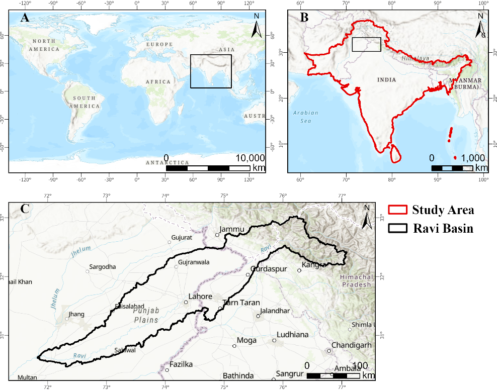
Floods is among the most devastating natural hazards in South Asia. The September 2025 flood in the Ravi Basin was triggered by heavy monsoon rainfall and the release of water from cross-border dams. This study utilized Sentinel-1 SAR data, including both ascending and descending passes in VH polarization, to map flood inundation across the basin using a Random Forest classifier. Pre-flood and post-flood composites were prepared for April-May and 27 August to 5 September, respectively. The predictors feature includes VH_pre, VH_post, VH_diff, and VH_ratio. Terrain correction using the NASA DEM and landcover filtering with ESA WorldCover at 10m improved classification accuracy. Results showed that 1,885 km² of land was inundated, representing 5% of the total basin area. Approximately 260 settlements were impacted, including Dera Baba Nanak, Kartarpur, and the low-lying regions of Lahore. Croplands were the most affected class, with 1,610 km² flooded, followed by grasslands (90 km²) and sparse vegetation (62 km²). Built-up areas accounted for 0.7 km² of inundation, though the socio-economic impact was disproportionately high. Precipitation analysis from NOAA CPC confirmed rainfall clustering in the Sialkot and Narowal corridor. The peaks exceeding 800 mm/day cause this region as the epicenter of the flood. News reports corroborated satellite findings, noting that over 2.5 million displaced and more than 100 lives were lost. The study highlights how tributary floods involving the Ravi, Sutlej, and Chenab are emerging as severe hazards for Punjab. Findings underline the need for improved monitoring, resilient agricultural strategies, and disaster preparedness to mitigate future economic and food security risks.
References
R. K. Mall, R. K. Srivastava, T. Banerjee, O. P. Mishra, D. Bhatt, and G. Sonkar, “Disaster Risk Reduction Including Climate Change Adaptation Over South Asia: Challenges and Ways Forward,” Int. J. Disaster Risk Sci., vol. 10, no. 1, pp. 14–27, Mar. 2019, doi: 10.1007/S13753-018-0210-9/FIGURES/2.
V. Klemas, “Remote Sensing of Floods and Flood-Prone Areas: An Overview,” J. Coast. Res., vol. 31, no. 4, pp. 1005–1013, 2015, doi: https://doi.org/10.2112/JCOASTRES-D-14-00160.1.
G. S. & K. S. Rawat, “Mapping flooded areas utilizing Google Earth Engine and open SAR data: a comprehensive approach for disaster response,” Discov. Geosci., vol. 2, no. 5, 2024, doi: https://doi.org/10.1007/s44288-024-00006-4.
L. Wan, M. Liu, F. Wang, T. Zhang, and H. J. You, “Automatic extraction of flood inundation areas from SAR images: a case study of Jilin, China during the 2017 flood disaster,” Int. J. Remote Sens., vol. 40, no. 13, pp. 5050–5077, Jul. 2019, doi: 10.1080/01431161.2019.1577999.
K. Jenkins, J. Hall, V. Glenis, and C. Kilsby, “A Probabilistic Analysis of Surface Water Flood Risk in London,” Risk Anal., vol. 38, no. 6, pp. 1169–1182, Jun. 2018, doi: 10.1111/RISA.12930.
K. Calvin et al., “IPCC, 2023: Climate Change 2023: Synthesis Report. Contribution of Working Groups I, II and III to the Sixth Assessment Report of the Intergovernmental Panel on Climate Change [Core Writing Team, H. Lee and J. Romero (eds.)]. IPCC, Geneva, Switzerland.,” Jul. 2023, doi: 10.59327/IPCC/AR6-9789291691647.
W. Solecki, D. Roberts, and K. C. Seto, “Strategies to improve the impact of the IPCC Special Report on Climate Change and Cities,” Nat. Clim. Chang., vol. 14, no. 7, pp. 685–691, Jul. 2024, doi: 10.1038/S41558-024-02060-9;SUBJMETA.
S. S. J. T. Fasullo, B. L. Otto-Bliesner, “ENSO’s Changing Influence on Temperature, Precipitation, and Wildfire in a Warming Climate,” Geophys. Res. Lett., 2018, doi: https://doi.org/10.1029/2018GL079022.
N. J. & A. S. C. M. D. Flannigan, B. M. Wotton, G. A. Marshall, W. J. de Groot, J. Johnston, “Fuel moisture sensitivity to temperature and precipitation: climate change implications,” Clim. Change, vol. 134, pp. 59–71, 2016, doi: https://doi.org/10.1007/s10584-015-1521-0.
T. S. Ksiksi, T. Youssef, and E. Abdelmawla1, “Sea Level Rise and Abu Dhabi Coastlines: An Initial Assessment of the Impact on Land and Mangrove Areas,” J. Ecosyst. Ecography 2012 24, vol. 2, no. 4, pp. 1–5, Aug. 2012, doi: 10.4172/2157-7625.1000115.
P. B. Ashwini Kulkarni, T. P. Sabin, Jasti S. Chowdary, K. Koteswara Rao, P. Priya, Naveen Gandhi, “Precipitation Changes in India,” Assess. Clim. Chang. over Indian Reg. A Rep. Minist. Earth Sci. (MoES), Gov. India, 2020, [Online]. Available: https://link.springer.com/chapter/10.1007/978-981-15-4327-2_3
Q. Z. C. Rasul, Ghulam Dahe, Qin, “GLOBAL WARMING AND MELTING GLACIERS ALONG SOUTHERN SLOPES OF HKH RANGES,” Pakistan J. Meteorol., vol. 5, no. 9, 2005, [Online]. Available: https://www.pmd.gov.pk/rnd/rnd_files/vol5_issue9/6.Global Warming and Melting Glaciers along Southern Slopes of HKH Ranges.pdf
“UAE rains: Municipality worker drowns after tanker swept away by floodwaters in Al Dhaid region.” Accessed: Oct. 04, 2025. [Online]. Available: https://gulfnews.com/uae/emergencies/uae-rains-municipality-worker-drowns-after-tanker-swept-away-by-floodwaters-in-al-dhaid-region-1.102251666
A. Bijalwan, S. L. Swamy, C. M. Sharma, N. K. Sharma, and A. K. Tiwari, “Land-use, biomass and carbon estimation in dry tropical forest of Chhattisgarh region in India using satellite remote sensing and GIS,” J. For. Res., vol. 21, no. 2, pp. 161–170, Jun. 2010, doi: 10.1007/S11676-010-0026-Y/METRICS.
S. T. Varun Tiwari , Vinay Kumar, Mir Abdul Matin, Amrit Thapa, Walter Lee Ellenburg, Nishikant Gupta, “Flood inundation mapping- Kerala 2018; Harnessing the power of SAR, automatic threshold detection method and Google Earth Engine,” PLoS One, 2020, doi: https://doi.org/10.1371/journal.pone.0237324.
A. K. Agnihotri, A. Ohri, S. Gaur, Shivam, N. Das, and S. Mishra, “Flood inundation mapping and monitoring using SAR data and its impact on Ramganga River in Ganga basin,” Environ. Monit. Assess., vol. 191, no. 12, pp. 1–16, Dec. 2019, doi: 10.1007/S10661-019-7903-4/METRICS.
M. A. Aziz et al., “Delineating Flood Zones upon Employing Synthetic Aperture Data for the 2020 Flood in Bangladesh,” Earth Syst. Environ., vol. 6, no. 3, pp. 733–743, Sep. 2022, doi: 10.1007/S41748-022-00295-0/METRICS.
V. Chauhan and J. Dixit, “Fractal analysis of major faults and fractal dimension of lineaments in the Indo-Gangetic Plain on a regional scale,” Earthq. Sci., vol. 37, no. 2, pp. 107–121, 2024, [Online]. Available: https://doi.org/10.1016/j.eqs.2024.01.015
Q. M. Muhammad Rizwan, Xin Li, Yingying Chen, Lubna Anjum, Shanawar Hamid, Muhammad Yamin, Junaid Nawaz Chauhdary, Muhammad Adnan Shahid, “Simulating future flood risks under climate change in the source region of the Indus River,” J. Flood Risk Manag., 2022, doi: https://doi.org/10.1111/jfr3.12857.
T. E. F. and F. P. Stephanie Long, “Flood extent mapping for Namibia using change detection and thresholding with SAR,” Environ. Res. Lett., vol. 9, no. 3, 2014, doi: 10.1088/1748-9326/9/3/035002.
J. R. C. & M. W. Caroline Taylor, Tom R. Robinson, Stuart Dunning, “Glacial lake outburst floods threaten millions globally,” Nat. Commun., vol. 14, no. 487, 2023, doi: https://doi.org/10.1038/s41467-023-36033-x.
D. B. C. S. V. Anand Shankar, Ashish Kumar Sinha, “A Case Study of Heavy Rainfall Events and Resultant Flooding During the Summer Monsoon Season 2020 Over the River Catchments of North Bihar, India,” VayuMandal, vol. 48, no. 2, 2022, [Online]. Available: https://imetsociety.org/wp-content/pdf/vayumandal/2022482/2022482_7.pdf
K. Uddin, M. A. Matin, and F. J. Meyer, “Operational Flood Mapping Using Multi-Temporal Sentinel-1 SAR Images: A Case Study from Bangladesh,” Remote Sens. 2019, Vol. 11, Page 1581, vol. 11, no. 13, p. 1581, Jul. 2019, doi: 10.3390/RS11131581.
J. Wang et al., “Disaster mapping and assessment of Pakistan’s 2022 mega-flood based on multi-source data-driven approach,” Nat. Hazards, vol. 120, no. 4, pp. 3447–3466, Mar. 2024, doi: 10.1007/S11069-023-06337-8/METRICS.
“Pakistan issues flood warnings for Ravi, Sutlej rivers as monsoon death toll nears 800 | Arab News.” Accessed: Oct. 04, 2025. [Online]. Available: https://www.arabnews.com/node/2612940/amp
“BBC Lancashire on X: ‘“My family escaped Pakistan flooding just in time” https://t.co/pGD6frNGgF’ / X.” Accessed: Oct. 04, 2025. [Online]. Available: https://x.com/BBCLancashire/status/1962539392242774208
“Home - FFD Lahore.” Accessed: Oct. 04, 2025. [Online]. Available: https://ftp.pmd.gov.pk/home
“NDMA issues high-flood alert for Ravi as India releases water - Pakistan - DAWN.COM.” Accessed: Oct. 04, 2025. [Online]. Available: https://www.dawn.com/news/1937340
E. Özelkan, “Water Body Detection Analysis Using NDWI Indices Derived from Landsat-8 OLI,” Polish J. Environ. Stud., vol. 29, no. 2, pp. 1759–1769, 2020, doi: https://doi.org/10.15244/pjoes/110447.
B. A. B. Chandrababu Naik, “Extraction of Water-body Area from High-resolution Landsat Imagery,” Int. J. Electr. Comput. Eng., vol. 8, no. 6, p. 12, 2018, [Online]. Available: https://ijece.iaescore.com/index.php/IJECE/article/view/11740
A. Tarpanelli, A. C. Mondini, and S. Camici, “Effectiveness of Sentinel-1 and Sentinel-2 for flood detection assessment in Europe,” Nat. Hazards Earth Syst. Sci., vol. 22, no. 8, pp. 2473–2489, Aug. 2022, doi: 10.5194/NHESS-22-2473-2022.
O. S. Yilmaz, F. Gulgen, F. Balik Sanli, and A. M. Ates, “The Performance Analysis of Different Water Indices and Algorithms Using Sentinel-2 and Landsat-8 Images in Determining Water Surface: Demirkopru Dam Case Study,” Arab. J. Sci. Eng., vol. 48, no. 6, pp. 7883–7903, Jun. 2023, doi: 10.1007/S13369-022-07583-X/METRICS.
G. Nico, M. Pappalepore, G. Pasquariello, A. Refice, and S. Samarelli, “Comparison of SAR amplitude vs. coherence flood detection methods - a GIS application,” Int. J. Remote Sens., vol. 21, no. 8, pp. 1619–1631, Jan. 2000, doi: 10.1080/014311600209931.
T. A. Mohammed Siddique, “CCD-Conv1D: A deep learning based coherent change detection technique to monitor and forecast floods using Sentinel-1 images,” Remote Sens. Appl. Soc. Environ., vol. 37, p. 101440, 2025, doi: https://doi.org/10.1016/j.rsase.2024.101440.
B. I. Hassan Ait Naceur, “Machine learning-based optimization of flood susceptibility mapping in semi-arid zone,” DYSONA - Appl. Sci., 2025, [Online]. Available: https://applied.dysona.org/article_209038.html
Y. J. Yi Liu, “Convolutional Neural Network-Based Machine Vision for Non-Destructive Detection of Flooding in Packed Columns,” Sensors, vol. 23, no. 5, p. 2658, 2023, doi: https://doi.org/10.3390/s23052658.
M. M. Khuong H. Tran, “Surface Water Mapping and Flood Monitoring in the Mekong Delta Using Sentinel-1 SAR Time Series and Otsu Threshold,” Remote Sens, vol. 14, no. 22, p. 5721, 2022, doi: https://doi.org/10.3390/rs14225721.
“Rapid attribution of heavy rainfall events leading to the severe flooding in Western Europe during July 2021 - Zurich Climate Resilience Alliance.” Accessed: Oct. 04, 2025. [Online]. Available: https://zcralliance.org/resources/item/rapid-attribution-of-heavy-rainfall-events-leading-to-the-severe-flooding-in-western-europe-during-july-2021/
J. Liang and Desheng Liu, “A local thresholding approach to flood water delineation using Sentinel-1 SAR imagery,” ISPRS J. Photogramm. Remote Sens., vol. 159, pp. 53–62, 2020, doi: https://doi.org/10.1016/j.isprsjprs.2019.10.017.
A. T. Hamid Gulzar, Sajid Ghuffar, Syed Amer Mahmood, Saif Ullah Akhter, Hania Arif, Dmitry E. Kucher, “Assessment of land deformation and groundwater depletion using Sentinel-1 PS InSAR, GRACE, and Borehole data,” Remote Sens. Appl. Soc. Environ., vol. 39, p. 101639, 2025, doi: https://doi.org/10.1016/j.rsase.2025.101639.
“Pakistan: More than two million evacuated from deadly floods.” Accessed: Oct. 04, 2025. [Online]. Available: https://www.bbc.com/news/articles/cn0xjd7wvy1o
“Monsoon Rains Flood Pakistan.” Accessed: Oct. 04, 2025. [Online]. Available: https://earthobservatory.nasa.gov/images/154781/monsoon-rains-flood-pakistan
“‘Everything is gone’: Punjabi farmers suffer worst floods in three decades | India | The Guardian.” Accessed: Oct. 04, 2025. [Online]. Available: https://www.theguardian.com/world/2025/sep/06/everything-gone-punjabi-farmers-suffer-worst-floods-three-decades
“Mass evacuations in Pakistan’s flooded Punjab hit 300,000 in 48 hours | Climate Crisis News | Al Jazeera.” Accessed: Oct. 04, 2025. [Online]. Available: https://www.aljazeera.com/news/2025/9/3/mass-evacuations-in-pakistans-flooded-punjab-hit-300000-in-48-hours
“Watch: Luxury neighbourhood in Lahore submerged in floods.” Accessed: Oct. 04, 2025. [Online]. Available: https://www.bbc.com/news/videos/cm2vdm1pnd8o
“Five Lahore localities flooded by the Ravi - Pakistan - DAWN.COM.” Accessed: Oct. 04, 2025. [Online]. Available: https://www.dawn.com/news/1938079
S. F. . Yuneng Du, Luan Jingdong, Rafia Khatoon, “Flood Disaster in Pakistan and its Impact on Agriculture Growth (A Review),” Glob. Adv. Res. J. Agric. Sci., vol. 4, no. 12, 2015, [Online]. Available: https://www.researchgate.net/publication/286879062_Flood_Disaster_in_Pakistan_and_its_Impact_on_Agriculture_Growth_A_Review
S. H. Muhammad Junaid Siddiqui, “Rainfall–runoff, flood inundation and sensitivity analysis of the 2014 Pakistan flood in the Jhelum and Chenab river basin,” Hydrol. Sci. J., vol. 63, no. 13–14, pp. 1976–1997, 2018, doi: ps://doi.org/10.1080/02626667.2018.1546049.
“IMF team to assess flood spending later this month - Business - DAWN.COM.” Accessed: Oct. 04, 2025. [Online]. Available: https://www.dawn.com/news/1942071
Downloads
Published
How to Cite
Issue
Section
License
Copyright (c) 2025 50sea

This work is licensed under a Creative Commons Attribution 4.0 International License.


