
Appraisal of Urban Sprawl in Mega Cities of Punjab Pakistan in context of Socio-Political Issues using RS/GIS
DOI:
https://doi.org/10.33411/ijist/2019010308Keywords:
socio-political development, Urban Sprawl, Landsat, Biodiversity, Classification.Abstract
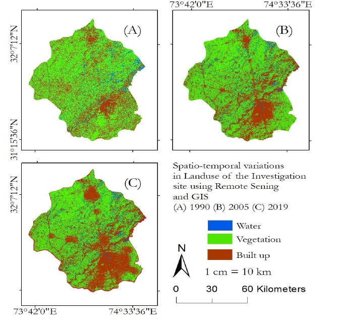
Urbanization has become a hot issue in context of environmental and socio-political scenarios which is addressed at every forum internationally. The mega cities are considered the main origin of socio-economic development which caused to emerge a number of issues like biodiversity, environmental degradation, resource consumption, implementation of law and order and provision of basic facilities to the general public. The area under investigation consists of Lahore, Gujranwala and Sheikhupura. The study site was bounded by 73-75 E longitudes and 31-33 N latitudes. We used Landsat satellite data to map Spatio-temporal variations in urban sprawl from 1990 to 2019 with a temporal window of 15 years. The Landsat data is free, highly reliable and considered as primary source. The classification results show that the total area of study site was site was 29355 km2 including 21933km2 were green index 4595 km2 was under human settlements and 2827 km2 was the waterbody in 1990. The classification of Landsat image of the year 2005 describes that area of human settlements was increased to 9366 km2, the volume of water body was reduced to 2111km2 and the vegetation was also degraded to 17878km2. Again, the urban area was computed using satellite imagery for the year 2019 which was 16105km2 in 2019. Kappa stat proved the accuracy of supervised classification what was around 87%. Remotely sensed datasets proved the reliability of Landsat satellite images for estimation of urban sprawl during last three decades.
Published
How to Cite
Issue
Section
License
Copyright (c) 2019 50Sea

This work is licensed under a Creative Commons Attribution 4.0 International License.


