
Analysis of Flood Damage Assessment through WorldView-2, Quick Bird and Multispectral Satellite Imagery in Southern Punjab, Pakistan
DOI:
https://doi.org/10.33411/ijist/2019010310Keywords:
Multi-spectral bands, GIS, RS, Visual Interpretation Elements, Supervised Classification, Worldview-2 and Quick Bird.Abstract
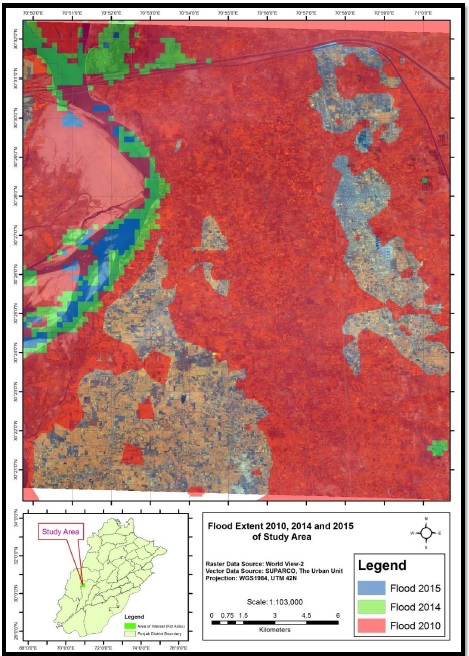
Pakistan has faced numerous natural disasters like floods, earthquakes, landslides and environmental degradation which severely affects the Pakistan’s economy and results in various problems like causalities, diseases, water stress and severe damages (e.g., houses, public infrastructure and agricultural land erosion). There is a lack of systematic approaches to analyze pre and post damage assessment for estimation of exact loses and the total cost for rehabilitation of damaged infrastructure in an efficient way. There exist a variety of mechanisms but GIS based flood mapping is considered the most efficient to manage the flood situation. This study is focused on evaluation of flood affected areas especially in Punjab using WorldView-2, 8-band multi-spectral imagery by applying Remote Sensing (RS) and GIS techniques. The research area is comprised of Kot Addu and Muzaffargarh Districts in Punjab province of Pakistan that faced a catastrophic super flood of 2010. The WorldView-2, Quick Bird and multispectral satellite imagery are capable of making better decisions and assessment of flood effected area accurately. RS and GIS techniques can achieve the objectives and significant analyses through visual interpretations. These techniques are also used to identify the flood affected regions. The study site was examined by applying supervised classification on the basis of the training areas which were obtained during the field surveys in the study site. Supervised classification determines that 16900.96 Hectors of agriculture land was damaged while Sparse Riverine Forest had the area 44.52 hectors. The damaged built-up area was 1805.78 Hectors. RS and GIS techniques are efficient for flood mapping.
Published
How to Cite
Issue
Section
License
Copyright (c) 2019 50Sea

This work is licensed under a Creative Commons Attribution 4.0 International License.


