
Active Surface Deformation from DEM Based Surface Dynamics in Upstream of Mangla Reservoir and Eastern Potwar Plateau
DOI:
https://doi.org/10.33411/ijist/2020020203Abstract
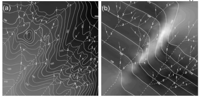
Digital Elevation Model (DEM) acquired by Shutter Radar Topographic Mission (SRTM) is useful to compute Surface Dynamics (SDs) including, Drainage Density (DD), Topographic Relative Relief (TRR), Iso Base-Levels (IBL) and Topographic Vertical Dissection (TVD). It provides detailed information about the lithology based on erosional boundaries as well as delineation of active tectonic scarps. It confers a well-built connection among diverse stream Strahler ordering and the localized erosive or neotectonics conditions in an actively deforming topography. These techniques are rapid, proficient, and consistent to demarcate tectonic control even along or over the similar lithologies. This investigation appraises the eroding and uplifting landforms along upstream of Mangla reservoir in lower Jhelum valley. The aim is to delineate margins for lithological demarcation and to distinguish whether these are affected by neotectonics or not. We noticed unusual localbase-level inconsistency that may be related to the well-known active tectonic expressions.
References
Golts, S. & E. Rosenthal, E. A morphotectonic map of the northern Arava in Israel derived form is obase lines. Geomorphology, 1993. 7: 305-315 (1993).
Grohmann, C.H., C. Riccomini, & F.M. Alves. SRTM-based morphotectonic analysis of the Poc cos de Caldas Alkaline Massif, southeastern Brazil, Computers & Geosciences. 33(1) :10-19 (2007).
Garrote,J., G.G.Heydt, & R.T.Cox. Multi-stream order analyses in basin asymmetry: A tool to discriminate the influence of neotectonics in fluvial landscape development (Madrid basin,central Spain). Geomorphology. 102 :130 -144 (2008).
Filosofov, V. Brief guide to morphometric methods in search of tectonic structures. Saratov: Saratov University Public House (1960). (Russian language).
Pennock, E., R.J. Lillie, A. Zaman, & M.Yousaf. Structural Interpretation of Seismic Reflection Data from the Eastern Salt Range and Potwar Plateau. Pakistan, Bull. Amer Assoc.Petrol. Geol.73(7) : 841-857(1989).
Lillie, R.J., G.D.Johnson, M. Yousaf, A.S.H. Zamin, & R.S. Yeats. Structural Development within the Himalayan Foreland Fold-And-Thrust Belt of Pakistan. Beaumont & Tankard (eds.) Sedimentary basins and basin forming mechanisms. Can
a. Soc. Petro. Geol., Memoir. 73(7): 379-382 (1987).9
Mahmood, S. A. & R. Gloguen. Analysing spatial autocorrelation for hypsometric integral to discriminate neotectonics and lithologies using DEMs and GIS. GIScience and remote sensing.48(4): 541-565 (2011).
Strahler, A. N. Hypsometric (area-altitude) analysis of erosional topography, Geol. Soc. Am.Bull. 63(11): 1117 – 1142 (1952).
Grohmann, C.H., C. Riccomini, & M.A.C. Chamani. Regional scale analysis of landform configuration with base-level (isobase) maps. Hydrology and earth system sciences.15: 1493-1504 (2011).
Stewart, I. & P. Hannock. What is a fault scarp? Episodes,61: 256–263 (1990).
Zuchiewicz, W. & R. Oaks. Geomorphology and structure of the Bear River Range, north eastern Utah: a morphometric approach, Z. Geomorphol., Suppl.-Bd. 94: 41– 55 (1993).
Sant’Anna, L. G., H.D Schorscher. & C. Riccomini. Cenozoic tectonics of the Fonseca Basin region, eastern Quadril´ateroFerr´ıfero, MG, Brazil, J. S. Am. Earth Sci. 10:275–284 (1997).
Mahmood, S. A., S. Siddiqui, V. Liesenberg, R. Gloguen, & M. Rahnama. DEM based analysis of active deformation in Hindukush using river profiles, surface dynamics and polynomial trend surfaces, (in review) Geomorphology, 2012.
Published
How to Cite
Issue
Section
License
Copyright (c) 2020 50Sea

This work is licensed under a Creative Commons Attribution 4.0 International License.


